2.1 土地利用方式对土壤水资源状况的影响
2.1.1 塬面
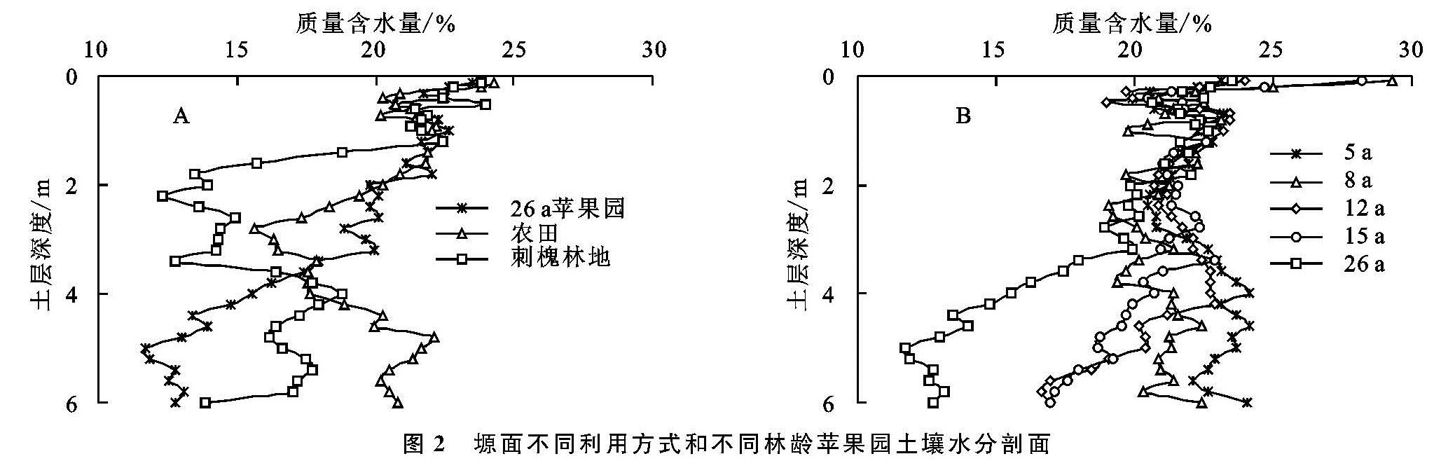
塬面农田、26 a苹果园、刺槐林地0—6 m平均湿度分别为19.9%,17.8%,17.1%,可见农田水分状况优于26 a苹果园、26 a苹果园优于刺槐林地,但是不同深度范围内土壤湿度变化并不一致。由图2A可知,雨季末,塬面0—1.4 m土层内农田、26 a苹果园、刺槐林地的土壤含水量均到田间持水量水平,分别为21.8%,22.0%,21.9%,储水量则分别为398,401,398 mm,方差分析表明无显著差异。1.4 m以下土层不同利用方式之间土壤水分出现明显差异,其中1.4—3.6 m深度范围内表现为26 a苹果园>农田>刺槐林地,平均含水量分别为19.9%,18.7%,14.6%,该层土壤水分状况在苹果园表现最好。3.6 m以下土层土壤水分表现为农田>刺槐林地>26 a苹果园,平均含水量分别19.9%,17.0%,13.8%,这表现出植被类型对深层土壤水分状况的影响,农田因作物根系深度较浅对深层土壤水分几乎没有影响,水分状况最好。
由图2B可以看出,不同林龄苹果园的土壤湿度随着深度的增加差异性逐渐增大。经过雨季降水补给,5,8,12,15,26 a的苹果园在0—2.6 m的平均含水量均保持在田间持水量水平,无显著差异,分别为21.6%,21.5%,21.6%,22.0%,21.3%,储水量均在730 mm左右。2.6—6 m不同林龄的苹果园的平均含水量分别为22.9%,20.9%,20.6%,19.8%,15.3%,呈现出随着林龄增加而减少的趋势,表明其对深层土壤水分状况的影响随林龄增加而增大。
2.1.2 梁顶
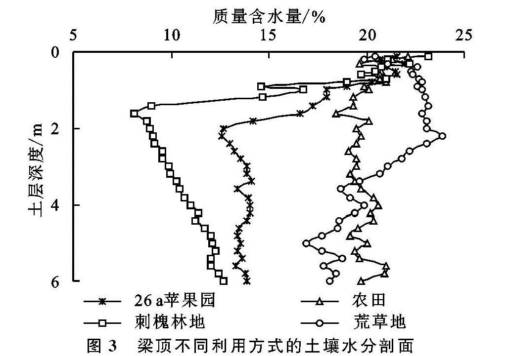
梁顶荒草地、农田、26 a苹果园、刺槐林地0—6 m土层平均含水量分别为20.6%,19.9%,15.1%,12.3%,荒草地土壤平均湿度均接近田间持水量,土壤水资源总体表现出荒草地>农田>26 a苹果园>刺槐林地的规律。由图3可知,在0—0.8 m土层内荒草地、农田、26 a苹果园、刺槐林地的平均土壤湿度均达到田间持水量且无显著差异,分别为21.8%,20.8%,21.2%,20.9%,储水量分别为226,217,220,218 mm。0.8 m以下土层不同利用方式之间土壤水分出现明显差异,其中0.8—3.4 m深度范围内表现为荒草地>农田>26 a苹果园>刺槐林地的规律,平均湿度分别为22.3%,19.4%,14.7%,10.2%,其中荒草地平均土壤含水量达到田间持水量水平,而刺槐林地土壤湿度在1.6 m处最小,其值为8.1%。3.4 m以下土层表现为农田>荒草地>26 a苹果园>刺槐林地的特征,平均土壤湿度分别为20.0%,18.5%,13.7%,11.6%,各利用方式的土壤水分差异随深度增加呈减小趋势。
图2 塬面不同利用方式和不同林龄苹果园土壤水分剖面
2.1.3 上坡位
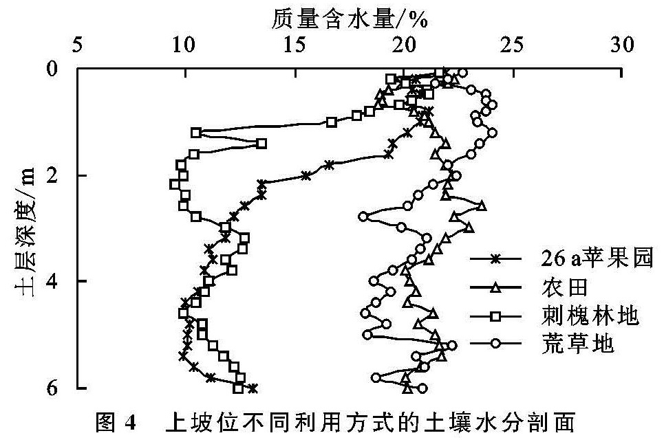
上坡位荒草地、农田、26 a苹果园、刺槐林地0—6 m土层平均含水量分别为20.9%,21.3%,14.0%,12.6%,荒草地和农田的平均土壤湿度均达到田间持水量,土壤水资源总体表现出农田(梯田)>荒草地>26 a苹果园>刺槐林地的规律,与梁顶一致。由图4可以看出,0—0.8 m土层范围内荒草地、农田、26 a苹果园、刺槐林地的平均土壤湿度分别为23.1%,20.3%,20.7%,20.2%,均接近或超过田间持水量,储水量分别为240,212,215,210 mm。0.8—3 m土层表现为农田(梯田)>荒草地>26 a苹果园>刺槐林地的规律,其平均含水量分别为22.1%,21.7%,15.9%,11.2%,该层荒草地和农田的平均土壤湿度均达到田间持水量水平,刺槐林地和苹果园的土壤含水量急剧减少,土地利用方式是影响该层土壤水分的主要因素。3—6 m土层不同利用方式的土壤水资源表现为农田>荒草地>刺槐林地>26 a苹果园的特征,其平均含水量分别为21.0%,19.8%,11.5%,10.8%,该层刺槐林地的土壤湿度有所增加,在3 m深度处反超苹果园,表现出苹果园3—6 m深度范围内发达的根系对水分的吸收消耗,使土壤水分含量保持在较低水平。
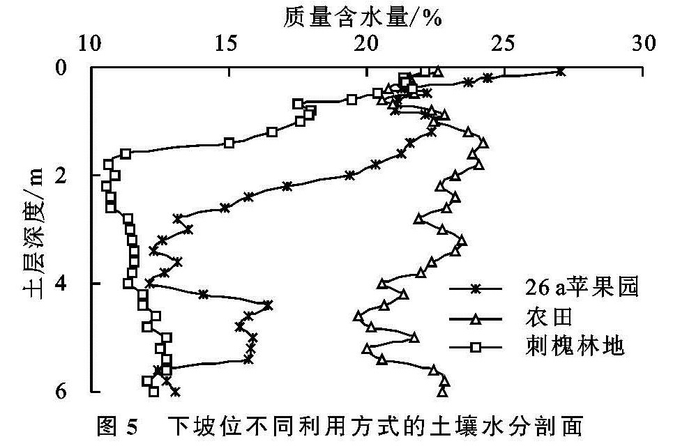
2.1.4 下坡位
由图5看出,下坡位农田在测定深度内的水分含量剖面变化不大,且其平均土壤湿度达到田间持水量水平,而苹果园、刺槐林地上下层的水分含量变化剧烈,3种利用类型0—6 m土层的平均土壤湿度依次分别为22.2%,16.7%,13.3%,表现为农田>苹果园>刺槐林地的特征。0—0.6 m范围内农田、苹果园、刺槐林地的平均土壤含水量分别为21.4%,23.3%,21.0%,该层各利用方式的土壤湿度较高。0.6—2.6 m土层苹果园、刺槐林地的土壤水分随深度增加急剧减小,农田则无显著变化。2.6—6 m范围内农田、苹果园、刺槐林地的平均土壤含水量分别为21.7%,14.0%,11.9%,各利用方式土壤湿度较上层有明显减小。刺槐林地从0.8 m以下深度的含水量即急剧减少到较低水平,至6 m均无大幅变化。
2.2 地形对土壤水资源状况的影响
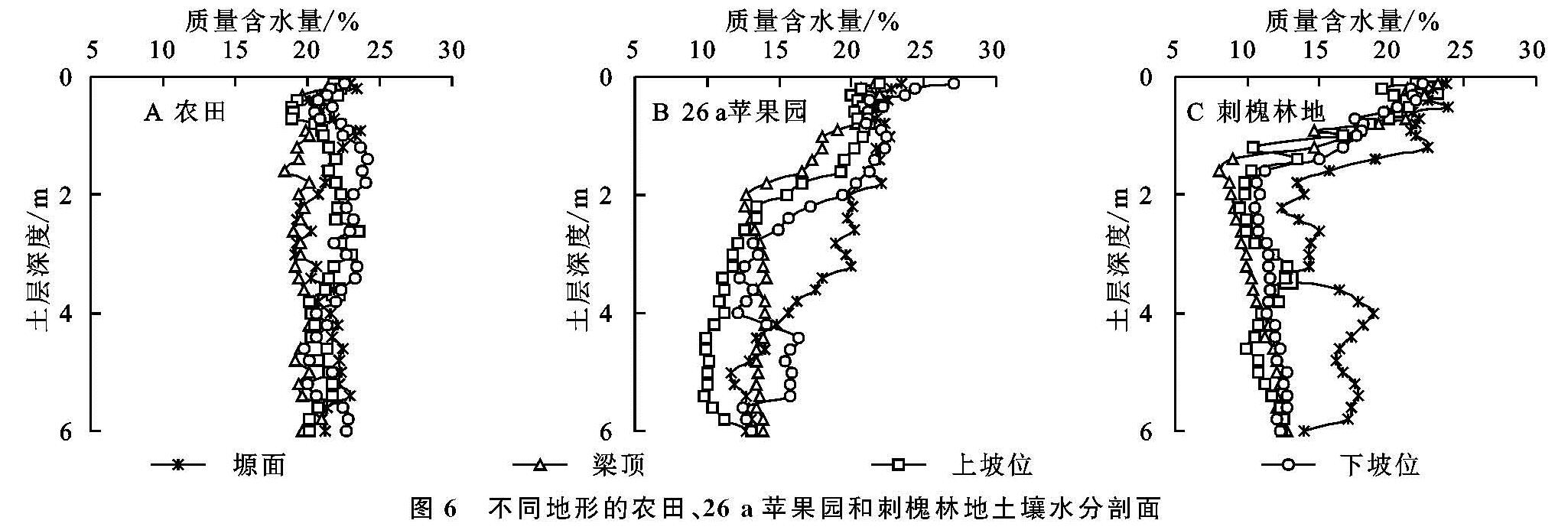
地形是土壤水分状况的重要影响因素之一,不同地形条件下同一土地利用方式土壤水分剖面分布具有一定的相似性,但土壤水分含量具有明显差异(图6)。农田0—6 m通层含水量都较高,平均土壤湿度表现出下坡位>上坡位>塬面>梁顶的规律(图6A),塬面和梁顶因有较好的管理措施,农作物产量较高导致水分消耗较多,加之梁顶有地表径流损失,因而土壤水分含量较低。
不同地形下苹果园和刺槐林地的土壤水分在0—6 m深度范围内均随深度增加而减小(图6B—C),其原因在于苹果和刺槐均为深根乔木,虽然在雨季末浅层土壤水分得到一定程度的恢复,但深层土壤依然处于干燥化状态。苹果园0—6 m土层平均湿度表现出塬面>下坡位>梁顶>上坡位的规律,刺槐林地则表现为塬面>下坡位>上坡位>梁顶。塬面地形平坦,土层深厚,降水可全部入渗补充土壤水,而坡地和梁顶有径流产生,损失部分降水量,因此塬面苹果园和刺槐林地土壤水分状况较好。
图6 不同地形的农田、26 a苹果园和刺槐林地土壤水分剖面