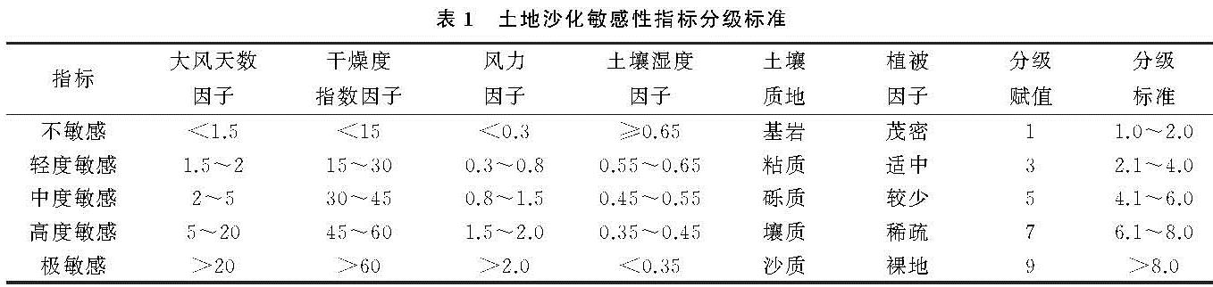
3.1 因子结果对比
(1)土壤湿度与干燥度指数比较。土壤湿度与干燥度指数在气象站点分布较多的区域,两者在空间上有较强的一致性(附图6)。空间上表现为大兴安岭地区、青藏高原南部地区和天山地区气候较为湿润,以轻度敏感和不敏感为主,塔里木盆地、准噶尔盆地、柴达木盆地和哈顺戈壁到阿拉善高原地区气候较为干旱,以高度敏感、极敏感为主。
在气象站点分布较少的区域,土壤湿度相对干燥度指数空间分布上更为精细。如在塔克拉玛干沙漠中心地区,气象站点较少,只有塔中和若羌两个气象站点,插值结果显示,除站点周边干燥度较大外,其余干燥度较小,这与塔克拉玛干沙漠的实际干旱情况不符。此外,干燥度指数因子显示呼伦贝尔、科尔沁和浑善达克地区分别为不敏感,不敏感和中度敏感地区,而土壤湿度因子显示这3个地区均为高度敏感地区。通过以往的研究发现,这3个地区蒸发量大降水量少,非常干旱[25-27]。
(2)风力因子与大风天数比较。同样,风力因子和大风天数因子在气象站点分布较多的区域,两者空间上有一致性(附图7)。空间上表现为大兴安岭、阿尔泰山、天山、昆仑山及研究区以南风力强度以不敏感和轻度敏感为主,阴山、贺兰山和祁连山以北、天山东缘,浑善达克及科尔沁地区风力强度以极敏感区为主。
在气象站点分布较少的区域,采用气象站点空间插值方法得到的大风天数因子显示塔里木盆地南部、柴达木盆地位于轻度敏感和中度敏感区,这与其他学者采用气象站点空间插值方法的结果相同[28],而风力因子显示这2个区域处于极敏感区,这与实际风场数据更加相符。因此,采用气象站点插值方法易遗漏气象站点密度低的大风区域。
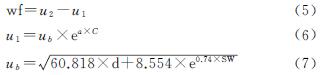
3.2 两种土地沙化敏感性评价结果比较
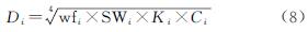
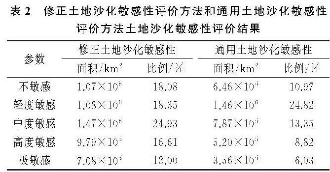
修正土地沙化敏感性评价方法和通用土地沙化敏感性评价方法关于土地沙化敏感性的评价结果见表2。修正土地沙化敏感性评价方法评估结果中,中度敏感区面积最大,为1.47×10⁶ km2,占研究区面积的24.93%; 极敏感区面积最小,为7.08×10⁵ km2,占研究区面积的12.00%。其中,土地沙漠化极敏感区主要分布在新疆维吾尔自治区、内蒙古自治区、甘肃省和青海省境内,面积分别为3.04×10⁵ km2,2.02×105 km2,1.00×105 km2,9.69万km2,西藏自治区、宁夏回族自治区、吉林省和山东省等地的土地沙漠化极敏感区面积较小,均小于1万km2。
通用土地沙化敏感性评价方法评估结果中,高度敏感区面积最大,为1.46×10⁶ km2,占研究区面积的24.82%; 极敏感区面积最小,为3.56×10⁵ km2,占研究区面积的6.03%。其中,土地沙漠化极敏感区主要分布在新疆维吾尔自治区、内蒙古自治区、甘肃省和青海省境内,面积分别为1.44×10⁵ km2,9.93万km2,7.11万km2,4.14万km2,西藏自治区土地沙漠化极敏感区面积较小,为1.91×10² km2。
表2 修正土地沙化敏感性评价方法和通用土地沙化敏感性评价方法土地沙化敏感性评价结果
从面积上看,两种方法均显示极敏感区面积最小,且省域极敏感区面积从大到小均为新疆维吾尔自治区、内蒙古自治区、甘肃省和青海省。但是,修正土地沙化敏感性评价方法评估结果中中度敏感区面积最大,而通用土地沙化敏感性评价方法评估结果中轻度敏感区面积最大,这可能是因为通用土地沙化敏感性评价方法中有25.97%地区评估结果为空值。
从分布上看,修正土地沙化敏感性评价方法和通用土地沙化敏感性评价方法都显示内蒙古北山地区、柴达木盆地、河西走廊北部、巴丹吉林沙漠北部边缘、狼山地区为土地沙漠化极敏感区,但通用土地沙化敏感性评价方法得到的极敏感区范围较小,没有覆盖准噶尔盆地西北部地区、塔里木盆地东部地区、柴达木盆地西部大部分地区、巴丹吉林沙漠南部地区和浑善达克西北部地区,与实际不符(附图8)。此外发现,修正土地沙化敏感性评价方法显示呼伦湖西部和科尔沁沙地为高度敏感区,部分区域为极敏感区,这与学者在呼伦湖[29]和科尔沁沙地的研究成果一致[30]; 而通用土地沙化敏感性评价方法显示呼伦湖西部和科尔沁沙地均为中度和轻度敏感区,这也与实际不符。同时,修正土地沙化敏感性评价方法和通用土地沙化敏感性评价方法都显示陇中、陇东黄土高原以中度和轻度敏感性为主[8],但通用土地沙化敏感性评价结果中度和轻度敏感区呈条带状分布,分界与降水量内插结果基本一致,而修正土地沙化敏感性评价结果中度和轻度敏感区与土地覆被边界吻合。因此,修正土地沙化敏感性评价方法模拟结果更准确和精细,与实际现状更相符。