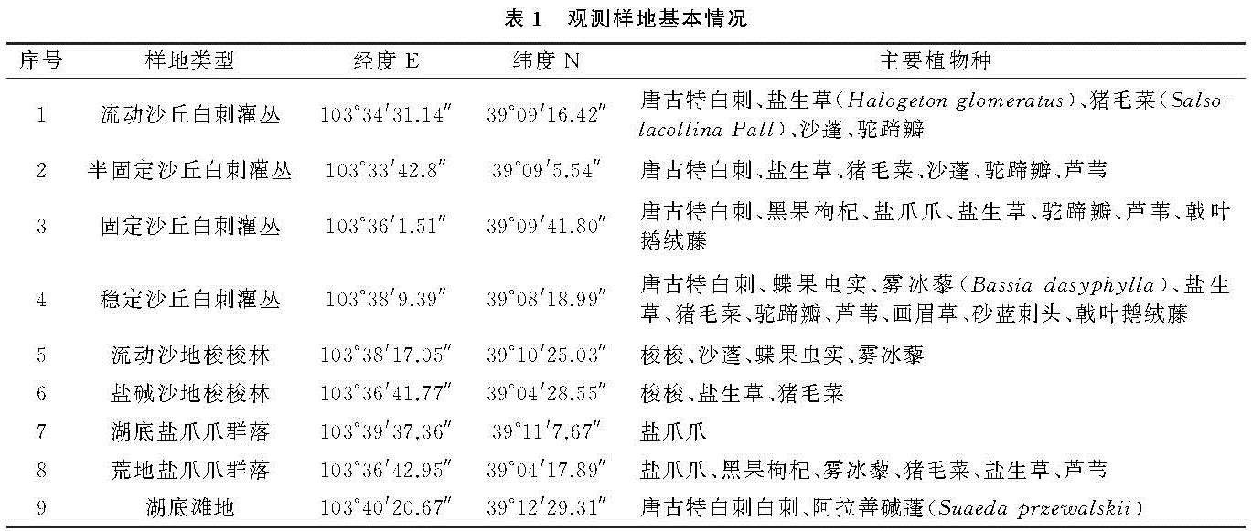
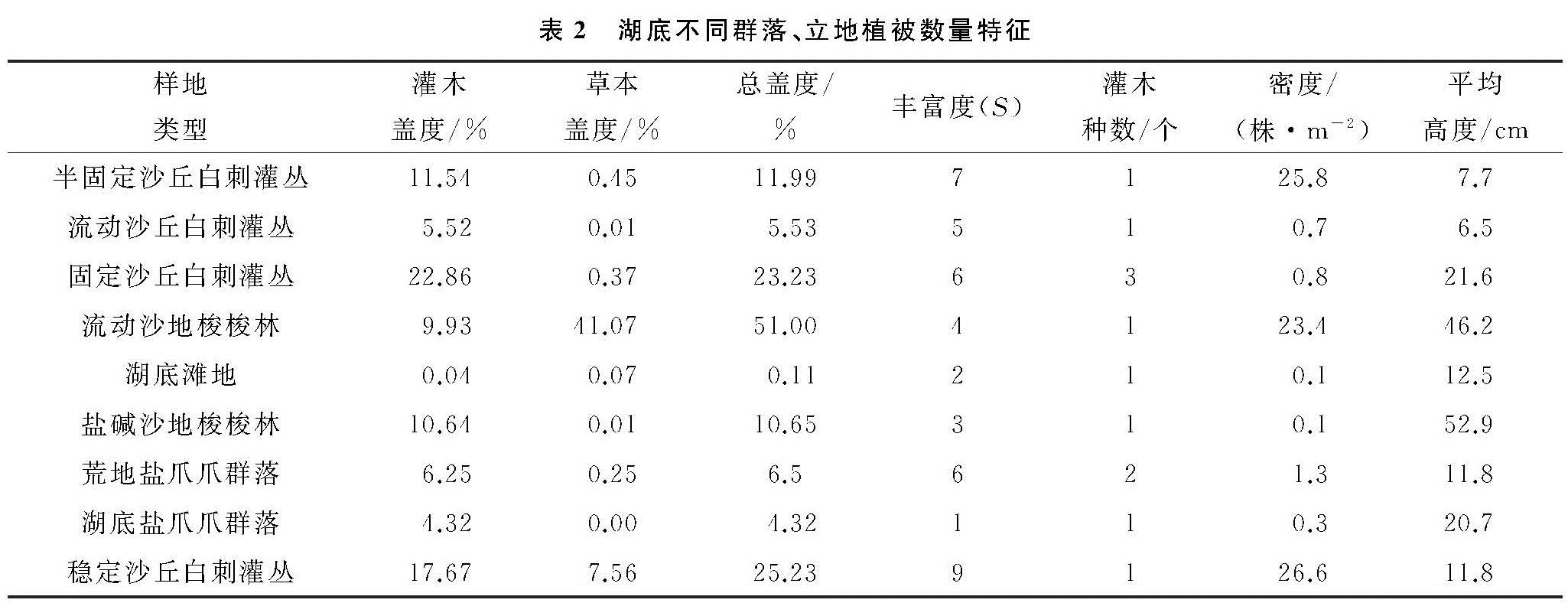
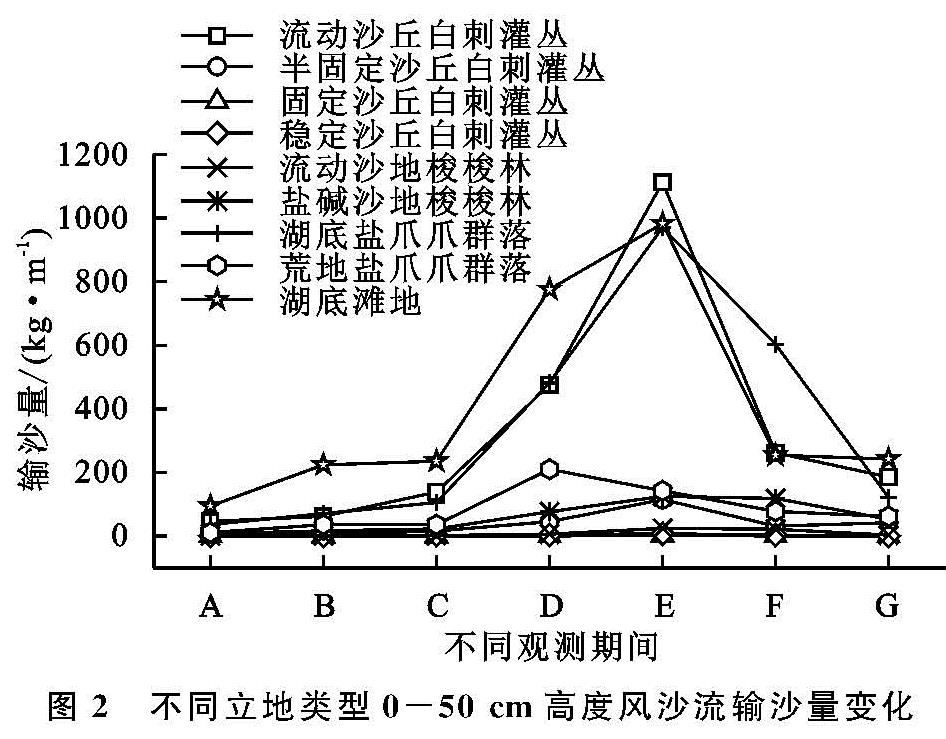
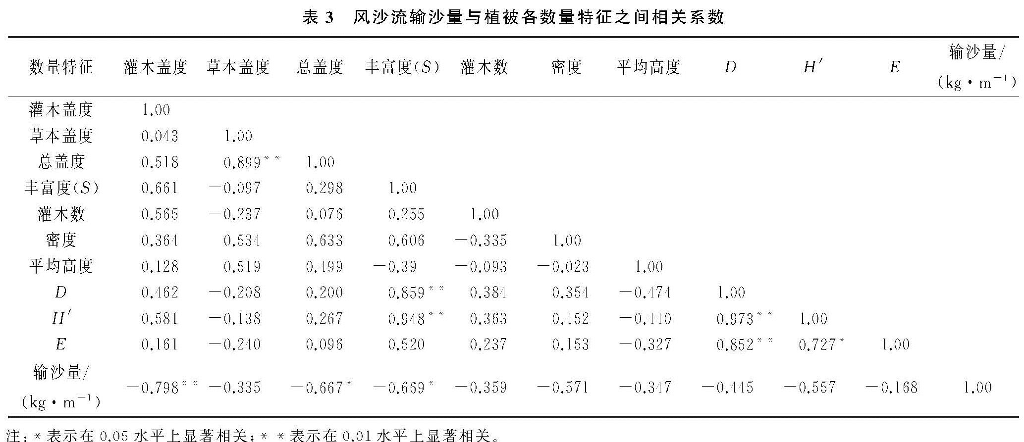
青土湖干涸湖底风沙区植被特征与地表输沙量关系

(1.甘肃省治沙研究所, 兰州 730070; 2.甘肃民勤荒漠草地生态系统国家野外科学观测研究站,甘肃 民勤 733300; 3.甘肃省荒漠化与风沙灾害防治国家重点实验室(培育基地), 甘肃 武威 733000)

石羊河; 干涸湖底; 植被特征; 输沙量

Relationship Between Vegetation Characteristics and Sediment Discharge Transported by Surface Wind-Sand Flow in Dry Lake Bottom Sandstorm Area of Qingtu Lake
GUO Shujiang1,2, YANG Zihui1,2,3, WANG Qiangqiang1,2, WANG Duoze1,2, WANG Fei1,3, FAN Baoli1,3, ZHANG Yijun1,2, LI Yiju1,2, WANG Mingguo1

(1.Gansu Desert Control Resesrch Institiute, Lanzhou 730070, China; 2.Gansu minqin National Studies Station for Desert Steppe Ecosystem, Minqin, Gansu 733300, China; 3.State Key Laboratory Breeding Base of Desertification and Aeolian Sand Disaster Combating, Wuwei, Gansu 733000, China)

Shiyang River; dry lake bottom; vegetation characteristics; sediment discharge

备注

以青土湖干涸湖底为研究对象,选择9种典型立地类型,开展群落组成、植被数量特征、地表风沙流输沙量的观测分析,研究了植被特征与输沙量之间的相互关系。结果 表明:青土湖干涸湖底主要风沙区灌木层植物4种,隶属4科4属; 草本层植物11种,隶属4科11属,灌木层平均盖度为11.2%,草本层平均盖度6.5%,植被稀疏,物种建群种单一。不同立地类型多样性指数和均匀度指数均呈现波动变化特征且存在差异性,其中流动沙丘白刺灌丛、固定沙丘白刺灌丛、荒地盐爪爪群落多样性指数较高; 固定沙丘白刺灌丛、流动沙丘白刺灌丛、湖底滩地植被分布较均匀。9种立地类型地表风沙流输沙量监测期各月呈现湖底滩地累计输沙量最大,湖底盐爪爪群落和流动沙丘白刺灌丛次之,且上述3种类型输沙量与其他6种立地类型输沙量存在显著差异(p<0.05)。湖底植被特征中灌木层盖度与地表平均输沙量呈显著负相关关系。

In this paper, Qingtu Lake dry lake bottom was taken as the research object, and nine typical site types were selected to carry out the observation and analysis of community composition, vegetation quantity characteristics and sediment discharge transported by surface wind-sand flow, and to study the relationship between vegetation quantity characteristics and sediment discharge. The results show that: four shrub layer plants, belonging to 4 families and 4 genera, were found in the main sandy area of Qingtu Lake; there are 11 herbaceous plants, belonging to 4 families and 11 genera, the average coverage of shrub layer was 11.2%, the average coverage of herbaceous layer was 6.5%, the vegetation was sparse, and the species construction was single; the diversity index and evenness index of different site types showed the fluctuation and difference, the diversity index of flowing Nitraria tangutorum shrub, fixed Nitraria tangutorum shrub and wasteland Kalidium foliatum community were higher; the vegetation distribution of fixed Nitraria tangutorum shrub, flowing Nitraria tangutorum shrub and lake shoal were more uniform; in the monitoring period, the sediment discharge transported by surface wind-sand flow of the nine sites types showed regularity in each month, and the accumulated sediment discharge of lake shoal was the largest, followed by the lake Kalidium foliatum community and the flowing Nitraria tangutorum shrub, and the sediment discharges of the above three types were significantly different from those of the other six types(p<0.05); among the quantitative characteristics of the vegetation at the bottom of the lake, there was a significant negative correlation between the shrub cover and the average sediment discharge transported by the surface wind-sand flow, and the increase of the shrub cover affected the sediment discharge transported by the wind-sand flow.