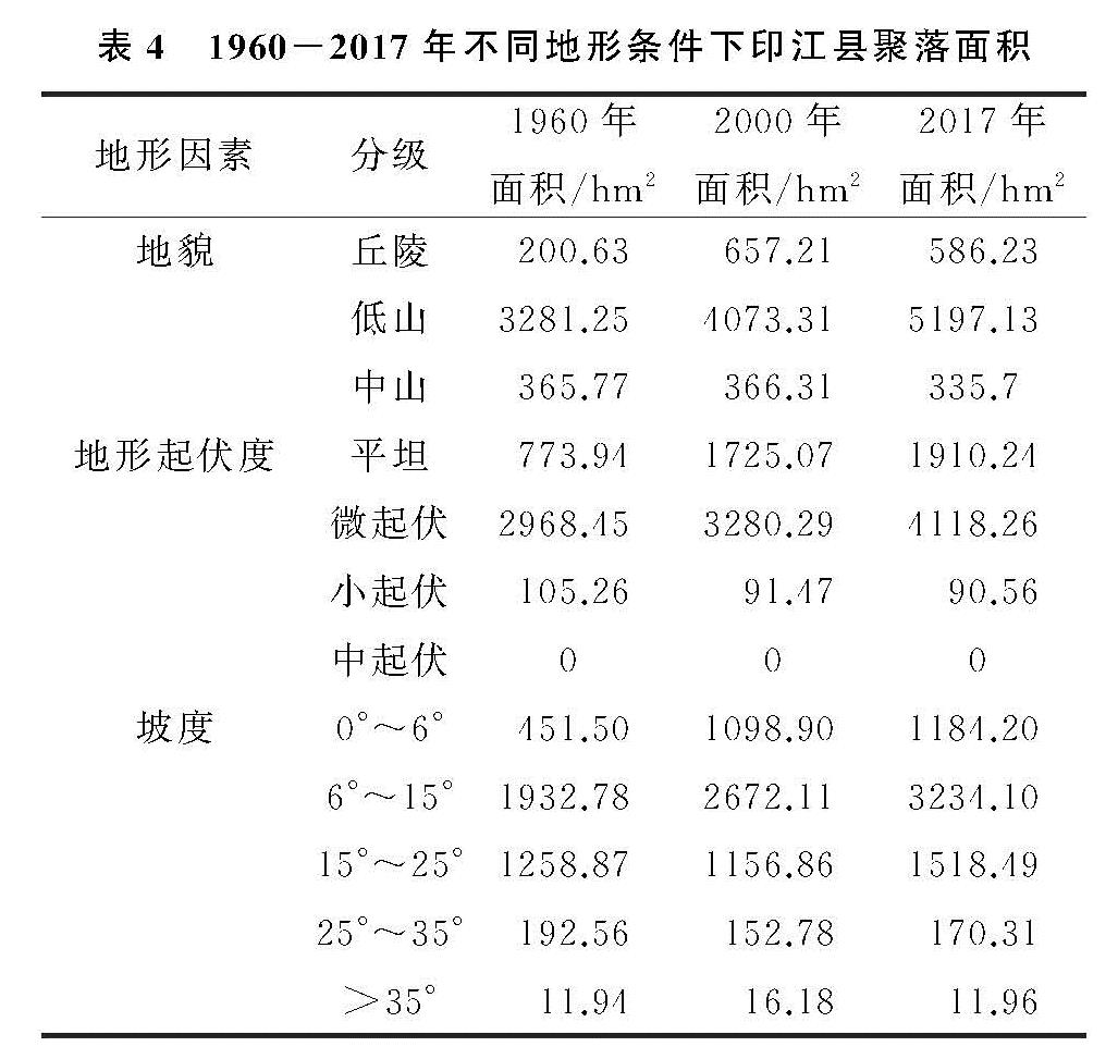
3.4.1 自然因素
(1)地形影响。区域自然地理背景是乡村聚落形成和发展的基础,地形是制约山区乡村聚落分布的重要因素,印江县东南部地势较高起伏度大,西北地势较为平坦,水土条件好。根据地貌划分方法,将研究区划分为丘陵(200~500 m)、低山(500~1 000 m)、中山(1 000~3 500 m),地形起伏度划分为平坦起伏(0~20 m)、微起伏(20~75)、小起伏(75~200 m)、中起伏(200~600 m),坡度划分为0°~6°,6°~15°,15°~25°,25°~35°、>35°。叠加矢量图层与乡村聚落数据,统计不同级别的聚落面积(表4)。
低山指向性明显。3个时期聚落主要分布在低山区,聚落面积占总面积的比例约为90%,聚落面积不断增加。丘陵区聚落面积增加385.6 hm2,占比提高4.37%。中山区聚落面积小,变化不大,占比持续下降。
低地形起伏度指向性明显。聚落主要分布在平坦区和微起伏区,两者之和占聚落总面积的95%以上,平坦起伏区和微起伏区的聚落面积持续增加,为1 136.3 hm2,1 149.81 hm2。小起伏区聚落面积小且占比持续降低,中起伏区均没有聚落分布。
低坡度(0°~15°)指向性明显。3个时期聚落面积为2 384.28 hm2 、3 771.01 hm2,4 418.30 hm2,占比为61.97%,73.99%,72.21%,增加2 034.02 hm2,是总增加面积的89.55%。15°~25°区域聚落面积先降后增,增加259.62 hm2。25°以上区域聚落面积变化不大占比小。
1960—2017年,地形的限制作用趋于减弱,聚落向起伏度较大、坡度较大的区域扩展。
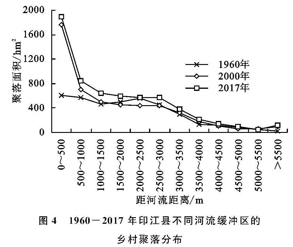
(2)河流影响。对印江县主要河流以500 m为间隔创建多环缓冲区,与乡村聚落图层进行叠加,统计不同距离缓冲区的聚落面积(图4)。随缓冲区距离增加,聚落面积均呈下降趋势。距道路越近,聚落规模增加越大,0~500 m之间,三个时期聚落面积分别为607.85 hm2,1 760.64 hm2,1 897.34 hm2,1960—2017年增加1 289.49 hm2。500~3 000 m之间,1960—2017年聚落面积增加686.2 hm2,3 000 m以上聚落面积变化小。乡村聚落空间演化近水性特征明显。河流提供饮用水和灌溉用水,2010年后,车家河、印江河、洋溪河开发为旅游区,沿河经济发展导致乡村聚落扩张,河流集聚作用增强。
(3)岩溶区影响。印江县岩溶地貌面积占总面积的44.50%,3个时期岩溶区聚落面积分别为1398.85 hm2,2189.61 hm2,2463.26 hm2,占比分别为36.36%,42.96%,40.26%,2000年占比最高。岩溶区内聚落面积增加1 064.41 hm2,占增加面积的46.86%,主要在1960—2000年增加,面积和比例分别为790.76 hm2,74.29%。说明岩溶区对乡村聚落发展的约束力增强,随着重视生态境保护,政府对生态脆弱区实施生态移民等政策,聚落向非岩溶区扩展。
表4 1960-2017年不同地形条件下印江县聚落面积
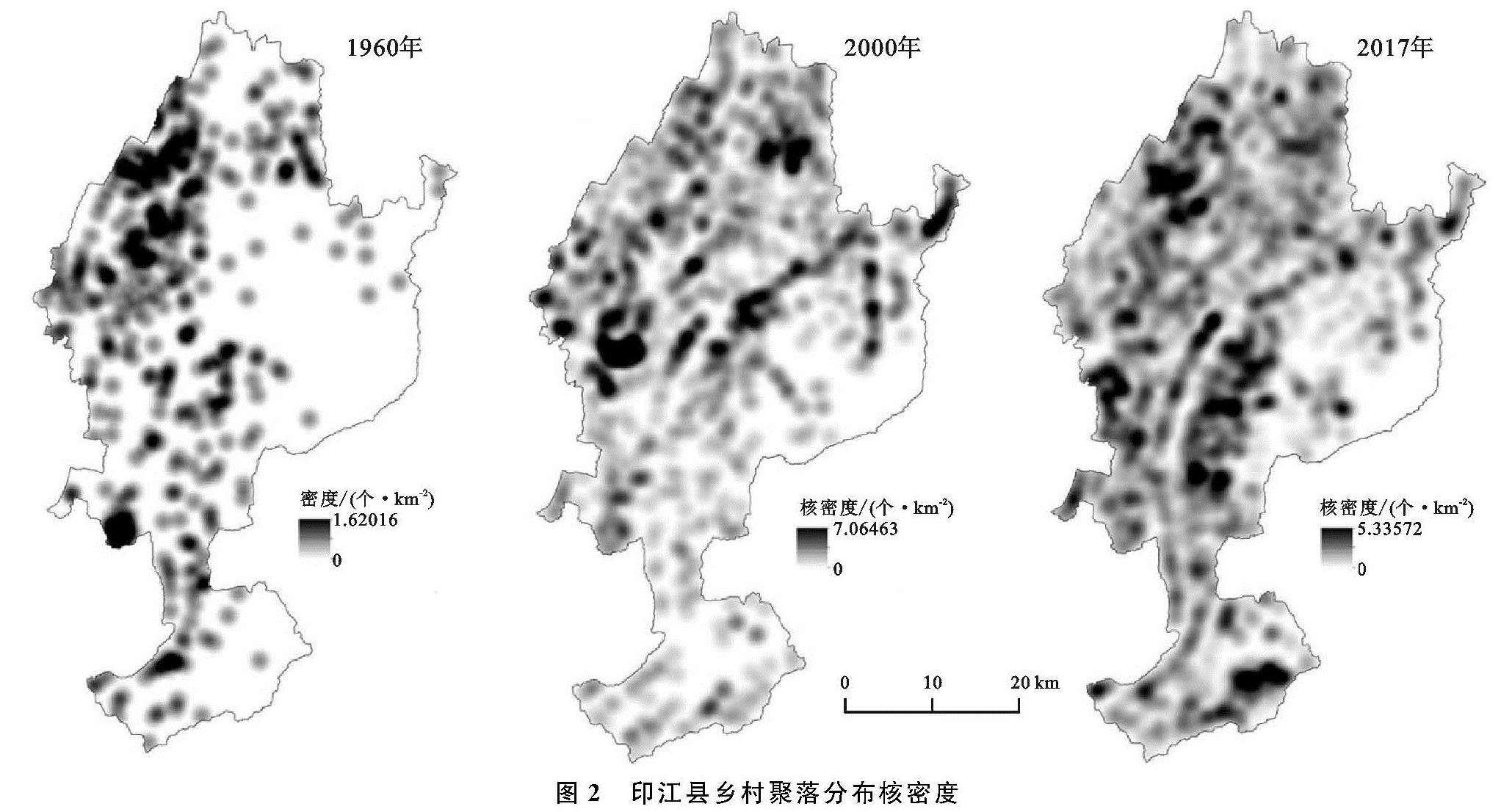
图4 1960-2017年印江县不同河流缓冲区的乡村聚落分布
3.4.2 人文因素
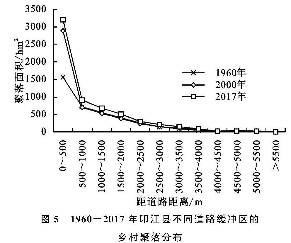
(1)道路影响。对印江县主要道路以500 m为间隔创建多环缓冲区,与乡村聚落图层进行叠加,统计不同距离缓冲区的聚落面积(图5)。距道路越近,聚落面积增加越大,0~500 m之间,三个时期聚落面积分别为1 551.37 hm2,2 885.78 hm2,3 206.53 hm2,1960—2017年增加1 655.16 hm2,500~1 000 m之间,1960—2017年聚落面积增加218.62 hm2。其余各缓冲区聚落面积小变化微弱,印江县乡村聚落分布具有明显的临路性,利于物质和信息交流,加强和城镇的联系。
河流和道路缓冲区下,聚落面积累计占比首次达到90%分别对应3 000~3 500 m及2 000~2 500 m范围,反映印江县乡村聚落临路性比近水性更突出,道路对乡村聚落演化的影响更大。
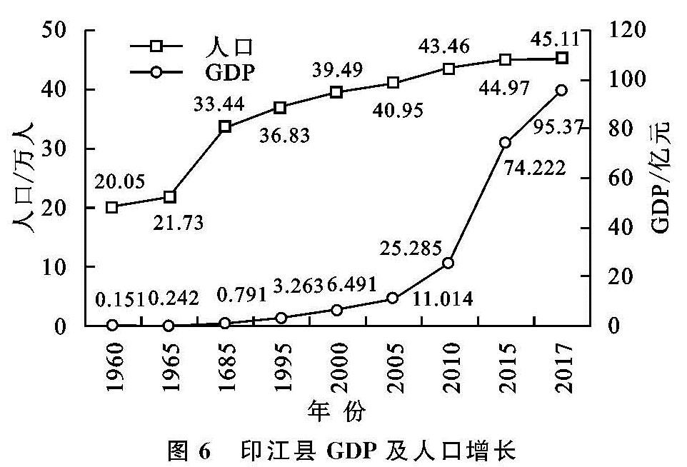
(2)人口和经济影响。人口是构成社会的基本要素,其变化对聚落演化有直接推动作用。1960年印江县农业人口为19.37万人,2017年农村户籍为35.69万人。山区耕地资源较少,聚落集中分布在耕作半径范围内,超过耕地人口承载力后,部分村民向条件较差的地区搬迁,聚落面积、个数增加。
聚落规模和经济发展呈正相关,乡村经济加速发展,村民增加收入,改变居住环境的意愿强烈。按当年价计算,两个时段内,印江县GDP年均增长率为9.86%和17.13%,人均GDP从1960年的75.31元提高至2017年的21 141.65元,相应的乡村聚落面积年均增长率为0.71%和1.08%。经济发展推动基础设施建设,高速公路G56经过罗场乡及峨岭街道,省道S304和S303经过木黄、合水、郎溪、缠溪等乡镇,均有核密度高值区分布,基础设施建设对聚落发展的吸引力较大。
图5 1960-2017年印江县不同道路缓冲区的乡村聚落分布
2000年前,农业是印江农户主要的生计方式和生活来源,经济发展缓慢,住房主要满足基本的生存需求,农村人口增加直接导致聚落规模增大。2000年后,印江三次产业结构从71.04:13.92:15.04调整为27.83:18.64:53.54,二三产业发展较快,村民改善性住房建设是聚落面积快速增加的原因(
图6)。
(3)重大历史事件影响。在某些时间点发生的事件对聚落格局演化产生重要影响,该类型事件可称为重大历史事件。
20世纪70年代以来国家开实施计划生育。印江县人口增长速率显著降低,1960—2000年,印江县人口年均增长率为20.5‰,2000—2017年为7.9‰。1978年,国家实行改革开放政策,1992年后市场经济不断深入,区域经济发展水平差距加大,吸引山区农业人口大量外出务工。印江县打工潮在90年代末达到高峰,打工经济增加收入,为乡村聚落发展提供资本。
1984年国家出台政策引导地方进行乡镇合并促进乡村发展。印江县2000年的行政区划为一镇七区,2017年调整为三街道十三镇一乡,建设形成木黄镇、天堂镇、缠溪镇及合水镇等中心镇,中心镇经济条件较好,政策支持力度大,基础设施较完善,吸引乡村聚落建设,扩大聚落面积。
自然灾害对聚落发展产生抑制作用。1960—2017年,印江县共有14次影响较大的水灾,1976年中兴街道大田村发生四级地震。1996年岩口山体滑坡造成堰塞湖。自然灾害损坏房屋,破环居住环境和生产环境,影响灾区的聚落发展,不改变印江县乡村聚落格局演化趋势。
2006年国家提出新农村建设后,印江县被确立为全国农村社区建设第二批试验县,得到资金支持,通过兴修基础设施和发展特色小城镇建设推动城乡一体化,带动乡村聚落发展。增减挂钩及易地扶贫搬迁等政策加速聚落演化,据统计,印江县共搬迁26 022人,均搬迁至县城,影响迁出地乡村聚落的格局和规模形态。