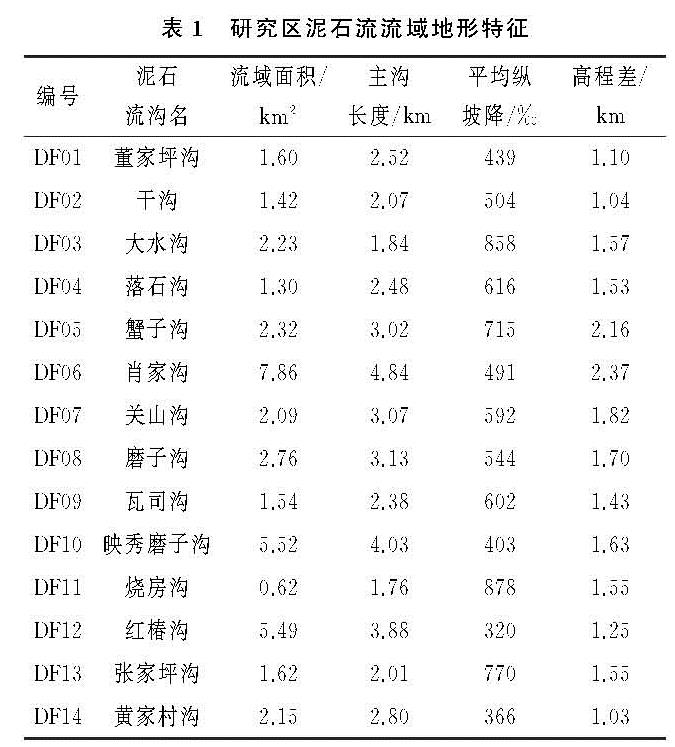
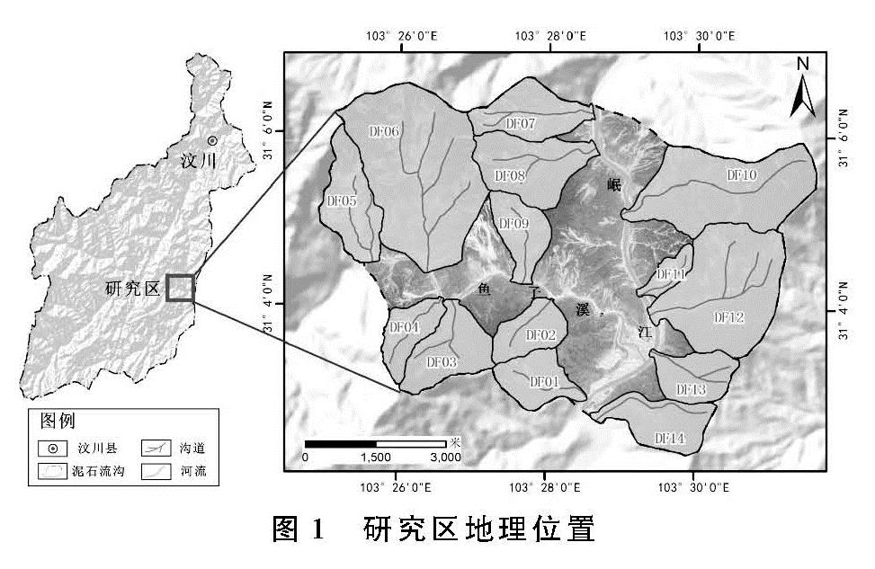
3.1 崩滑体物源变化规律
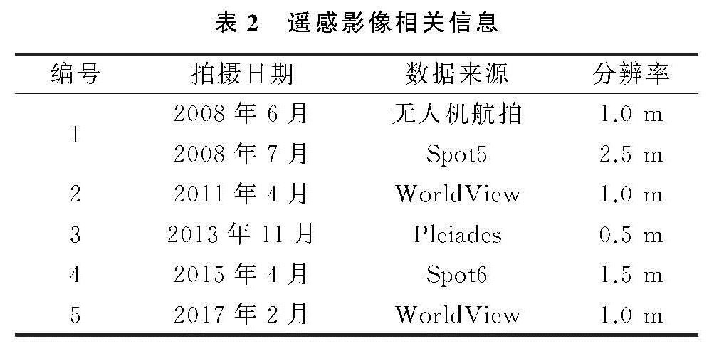
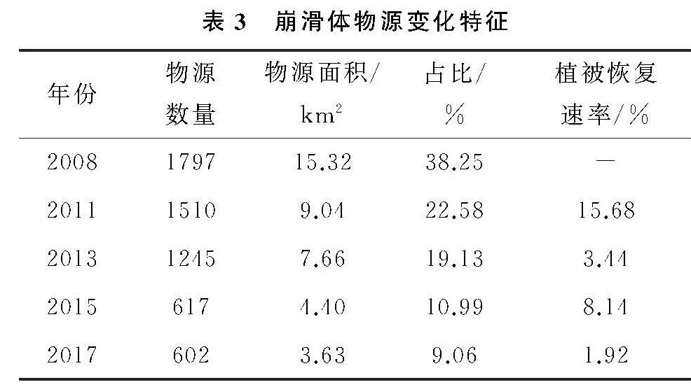
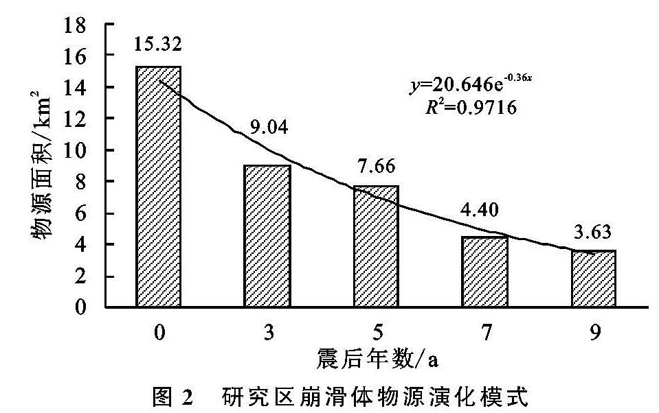
研究区流域总面积为39.09 km2,在2008年的遥感影像中,共解译出1 797处崩滑体物源,总面积为15.32 km2,占整个研究区流域面积的38.25%(表3)。从2008—2011年,物源数量减少了287处,面积从15.32 km2下降到9.04 km2,植被恢复的面积占整个研究区面积的15.68%。2013年7月10日,汶川震区持续强降雨,研究区再次暴发大规模泥石流事件,使得许多植被严重损毁,也直接导致2011—2013年的植被恢复率骤然降低为3.44%,物源的面积减少了1.38 km2。从2013—2017年,物源的数量和面积都有所减少,恢复的速率逐渐变缓,物源的数量从1 245处减少到617处再减少至602处,因此物源的数量变化波动较大,而物源的面积仍在持续减少,从7.66 km2下降到了3.63 km2,仅占整个研究区流域面积的9.06%,达到了一个较低的水平。
大部分物源的可视形态随着时间的推移都在不断变化,比如一个面积较大的物源通常会被恢复的植被分隔为若干个面积较小的物源,因此物源的数量波动较大且并不能真实反映物源的演化趋势,所以选取物源面积为指标探究物源的演化模式。将横坐标定义为震后的年数,则已统计的2008年、2011年、2013年、2015年及2017年的横坐标分别为0,3,5,7,9,结果发现物源面积以对数函数模式演化(图2),预测于2030年前后物源面积降低到0.01 km2以下,表明经过物源逐渐趋向稳定、输出,流域内泥石流物源面积较震初已明显减少,基本恢复至震前水平,但在强降雨或地震等作用下仍具有暴发泥石流自然灾害事件的可能。黄润秋学者在相关研究中也提出,震后汶川地震灾区的地质灾害将持续20~25 a,并最终恢复到震前的水平,与本文得出的结论基本一致[4]。
3.2 崩滑体物源时空分布变化与高程的关系分析
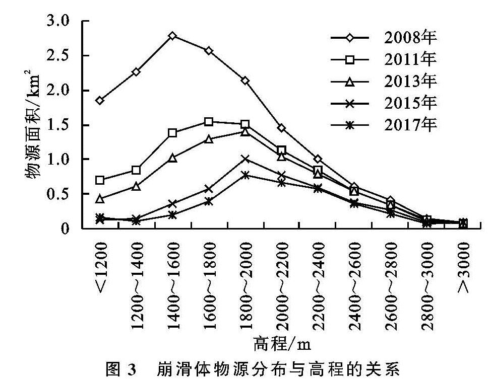
本文以200 m为间隔对研究区高程进行分级,整个研究区高程划分为11级,然后统计每一级中的物源面积,结果见图3。图3显示崩滑体物源面积随高程的增加,表现出先增加后降低趋势,即崩滑体物源集中分布在某段高程优势区间内。图3显示1 400~2 000 m为崩滑体的优势分布高程范围,即研究区物源主要集中分布于靠近河谷的低、中高程处。分析认为这主要是由于该高程范围多为靠近沟道区域,受河谷地形切割作用,更有利于临空面发育,从而使得崩滑体较为发育,且往往形成规模大的崩滑体,而靠近山脊处多发育大量小型崩滑体。这样的物源分布形式直接影响到泥石流松散物质的数量和补给方式,从而间接影响泥石流的暴发规模,且有利于泥石流的形成。由图3可知2008年、2011年、2013年、2015年以及2017年研究区物源面积的峰值分别位于1 400~1 600 m,1 600~1 800 m,1 800~2 000 m,1 800~2 000 m和1 800~2 000 m,该结果可以看出2008—2017年研究区崩滑体物源集中发育的高程区间逐渐由1 400~1 600 m转变为1 800~2 000 m。这表明,震后随着时间推移,物源发育的优势高程区间有向高海拔方向发展的演化趋势,且从纵向变化可以看出,相对于高海拔地区,低海拔地区物源的植被恢复速率更快。另外由图3看出,每年物源面积的曲线在高程增长到2 200 m后都呈现出急速下降的趋势,这是由于研究区2 200 m以上的分级区域覆盖面积过小造成的。
3.3 崩滑体物源时空分布变化与地形坡度的关系分析
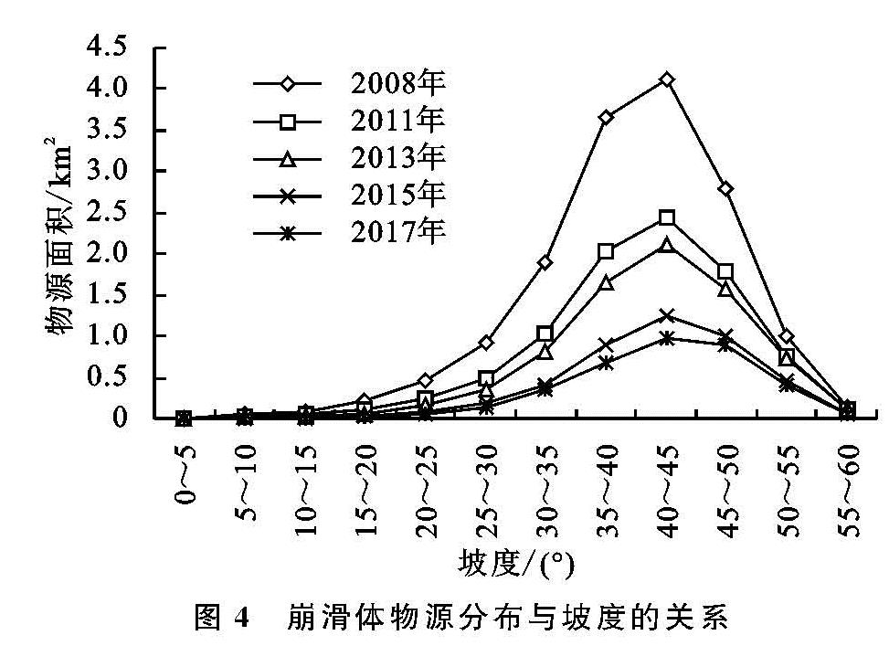
通过ArcGIS中3 D-analysis模块下的aspect工具提取研究区的整体坡度,然后将物源规模进行叠加提取,以5°为间隔对物源发育坡度进行统计分析。从统计结果(图4)的横向变化趋势可以看出,随着坡度增加物源面积逐渐增大,在坡度为40°~45°时达到了最大值,随后又迅速降低。坡度是影响斜坡失稳重要因素,坡体的应力分布状态随着坡角的变化而改变,一般坡角越大,坡面张力带范围会扩大,坡脚应力集中。同时坡度变大,沿滑面的自重分力也会增大,导致坡体的稳定性变差[10]。有学者研究指出,坡度大于45°地方松散碎屑物质发育较薄,不利于浅层滑坡发生[11],若坡度低于20°,则由于坡度太小,不利于坡体失稳破坏[12]。本文通过解译统计结果可知,多期物源面积的曲线都在40°~45°的坡度区间达到了峰值,随后则开始迅速减小,该结论与前人结论一致。
从纵向变化趋势来看,2008—2011年这个时间段内各个坡度区间的物源面积减少较多。这是由于地震后山体松弛、地表破碎,松散物源充足,2010年研究区普遍暴发强降雨,在强降雨作用使大量靠近沟道两侧崩塌、滑坡物源直接进入主沟或支沟,支沟物源经过地表径流冲刷或泥石流挟带作用与主沟相连接,将大量崩滑物源输出沟口,使得坡面上崩滑物源逐渐减少。从2011—2013年物源恢复的速度骤然变缓,研究区在强降雨触发条件下,进一步诱发新的崩塌、滑坡等不良地质现象,使大量原本已恢复的植被遭到破坏,暴发了7.10群发性泥石流事件。而从2013—2017年,各个坡度区间的物源面积不断减少且减少速度逐渐放缓,表明随着时间发展,震区地质环境逐渐改善,植被恢复、泥石流物源趋于稳定。
3.4 崩滑体物源时空分布变化与坡向的关系分析
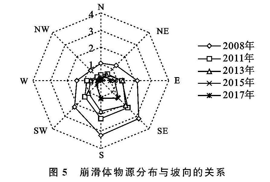
坡向对崩滑体物源的分布有着重要影响。不同坡向的斜坡受到的太阳辐射强度不同,影响了斜坡的水蒸发量、植被覆盖、坡面侵蚀等诸多因素,进而改变了斜坡地下水孔隙压力的分布及岩土体物理力学特征,使得斜坡稳定性产生差异[13]。因此,不同坡向的崩滑体物源具有不同的变化特征。
在ArcGIS通过提取分析工具得到研究区的整体坡向后,将物源规模进行叠加并对物源发育坡向进行了统计分析。由统计结果图5可知,物源在坡向为S,SE时面密度较大,坡向为NW时面密度最低。穿过研究区的映秀—北川发震断裂的走向为SW-NE,崩滑体集中发育的坡向与发震断裂的位移运动方向大致相同。表明了地震引起的滑坡崩塌受到了地壳主应力方向、上盘逆冲方向或地震波的传播方向的影响。研究区处于汶川地震极震区,在极震区由地震形成的崩滑体具有一定的“背坡面效应”,而“背坡面效应”是指与发震断裂带近于垂直或者大角度相交的沟谷斜坡中,在地震波传播的背坡面一侧的地质灾害点发育密度明显大于迎坡面一侧,因此崩滑体物源的面密度也相对较大。结果还显示出,发育在S,SE坡向的物源每年恢复的物源面积也是最大的,这是由于在该坡向崩滑体发育更为突出,物源面积基数大,且为向阳坡,降雨集中,所以崩滑体物源更易被降雨冲刷带到沟道成为沟道物源或冲出沟口。
3.5 崩滑体物源时空分布变化与距沟道距离的关系分析
距沟道距离是崩滑体活动的间接影响因子。为了探究距沟道距离对物源时空分布的影响,本文通过ArcGIS中的邻域分析工具,以200 m为间距创建流域内沟道的多环缓冲区,共分为6级,然后统计不同距离范围内物源的面积。如图6所示,每期的物源面积发育与距沟道距离表现为负相关,随着距沟道距离的增加,其控制作用逐渐减弱,直到距沟道距离为1 000~1 200 m时几乎衰减为零。由于沟道附近的汇水量较大,可以促进斜坡坡脚的失稳,从而导致崩滑体活动,使得沟道附近崩滑体物源的活动性较高,且随着距沟道距离的增加活动性逐渐减弱。从纵向变化来看,2008—2011年、2013—2015年的物源面积曲线相对变化较大,而这个时间节点正是研究区暴发2010年“8·13”泥石流与2013年“7·10”泥石流事件后所发生的的突变,由此可见,区域内暴发大规模泥石流事件后,距沟道距离对物源发育的控制作用也会发生较大波动。