3.1 耕地综合质量分析
通过区位通达性修正系数、发展稳定性系数和人文因素等对耕地自然质量进行逐级修正,综合评价得出南岸区耕地入选高标准基本农田的综合质量。全区耕地综合质量得分介于16.51~73.31,耕地平均综合质量得分42.7,全区耕地综合质量整体一般且区域内部差异比较大。采用自然断点法将耕地综合质量划为4级,分别是Ⅰ级(分值大于等于54.01)耕地综合质量最高,Ⅱ级(分值为42.46~54.01)耕地综合质量较高,Ⅲ级(分值为32.53~42.46)耕地综合质量一般,Ⅳ级(分值小于32.53)耕地综合质量最差。经逐级修正后耕地综合质量较高的优质耕地重心略微向研究区中部偏移,在空间上整体呈由西至东阶梯式分布,即在研究区西部整体耕地综合质量最低,耕地综合质量向研究区中部逐渐上升,综合质量较高的耕地主要分布研究区东部。
根据逐级修正后得到综合质量评价结果见表3,耕地综合质量为Ⅱ级的耕地最多,占全区耕地总面积的31.95%,主要分布在研究区中部的长生桥镇和研究区东部,相较于修正前的结果,Ⅱ级耕地增加了4.83%,其原因主要是受人文因素的影响,在这些地区农户及政府的支持度较高,由于前几轮基本农田多划定在这些区域,农户对基本农田的认知度较高、理解基本农田对耕地的保护作用,而地方政府由于城市化扩展对建设用地的需求相对于其他乡镇要小得多,因此对划定基本农田的抗拒程度较小; 其次是综合质量为Ⅲ级的耕地,占全区耕地总面积的30.85%,主要分布在迎龙镇、峡口镇和长生桥镇,相较于修正前的结果,Ⅲ级耕地减少了3.51%,其原因主要是受到发展稳定性因素的影响,这些耕地受城镇的影响较大,影响耕地后期的保护和利用,在发展稳定性方面较差; 然后是综合质量为Ⅳ级的耕地,占全区耕地总面积的19.74%; 综合质量为Ⅰ级的耕地最少,占全区耕地总面积的17.47%,这类耕地与修正前相比减少了2.15%,主要分布在研究区东部地势条件好、交通区位较好以及发展比较稳定的区域,这些耕地空间形态、有效土层厚度等土壤肥力因子也比较好。
3.2 高标准基本农田建设方向
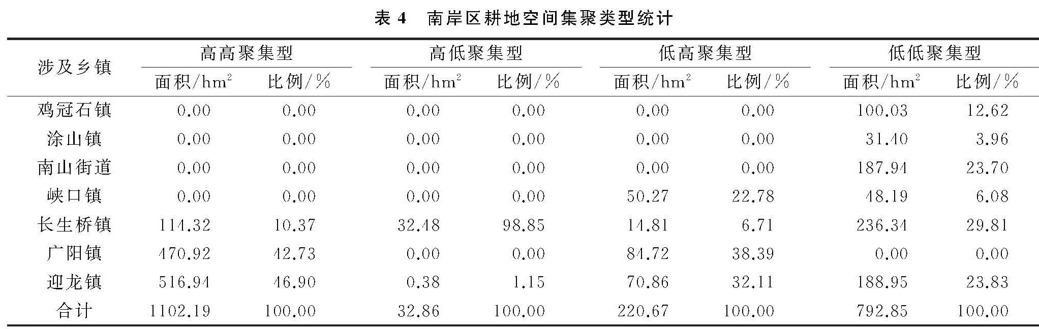
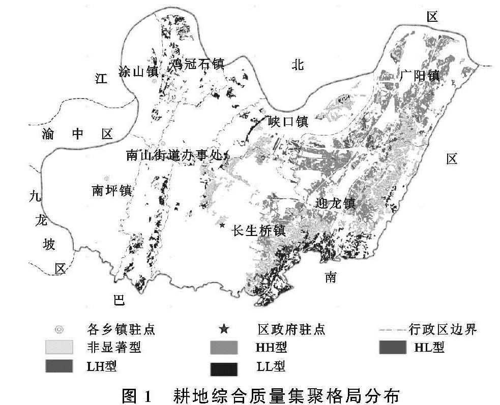
基于空间集聚格局,对耕地综合质量分值进行局部空间自相关分析,得到耕地综合质量空间集聚类型,包括高高聚集型(HH)、高低聚集型(HL)、低高聚集型(LH)、低低聚集型(LL)和非显著型5种类型,南岸区耕地空间集聚格局情况见表4,其空间分布情况如图1所示。
HH型包含了耕地综合质量为Ⅰ级和Ⅱ级的大部分耕地,面积约1 108.19 hm
2,包括1 388个地块。这类型全部分布在研究区东部和研究区中部,且分布面积较大,规模指数和斑块形状指数较大,耕地空间形态最优。这类耕地多数土壤质量较高、农田基础设施完善,耕作半径较小、耕地区位通达性较好,便于农户耕作经营土地,空间集聚度较高,受城镇发展的干扰较小,且农户的支持度较高,有利于高标准基本农田划定后的保护和耕种,可以优先划定为高标准基本农田建设区域。这些耕地所在地势较为平坦、交通区位条件好,有利于农业的规模化、机械化生产,划为高标准基本农田实行特殊保护,提高全区粮食产量,保障粮食安全。
HL型主要是耕地综合质量较高的地块周边被低质量地块包围,零星分布在研究区中部的长生桥镇和研究区东部部分地区,该类耕地面积约32.86 hm2,包括23个地块。这些耕地本身综合质量较高,但是周边耕地质量差,距离优质耕地较远,零星、分散式的分布于各乡镇,难以形成集中连片的基本农田,不利于高标准基本农田划定后期的保护和监管。因此该类耕地不适宜划入高标准基本农田,但可以发展观光农业、科研示范农田,提高农户种植收益的同时也集约节约利用耕地。
LH型主要是分布在高高聚集型耕地之间本身综合质量较低的耕地,主要分布在研究区东部的广阳镇、迎龙镇,面积约220.67 hm2,包括310个地块。这些耕地穿插在优质耕地之中,其本身质量一般,但其与周边高质量耕地相接,规模指数较高。随着土地整治工作的进一步推进,提升耕地质量,引导周边非农用地退出,整合零散的耕地,完善农田基础设施,这类耕地更容易与周边高质量耕地形成集中连片度高、耕地地力肥沃的基本农田。因此这部分耕地也可划入高标准基本农田。
LL型多数为耕地综合质量低的地块,由于南岸区本身的地形地貌,导致多数耕地程零星式、分散式分布,且受坡度、土壤厚度等自然因子限制,耕地综合质量较低。这类耕地面积约792.85 hm2,包括1 031个地块,这些耕地多位于偏远交通不便且坡度较大的山区,不利于耕作和生态保护,因此不宜划入高标准基本农田建设区域。但这类耕地所处地区承担着城市的生态保护任务,应对其加以特殊保护,限制肆意无序的开发行为,其本身优美的自然环境,可以适当开发旅游业。
根据高标准基本农田的内涵和建设目标,充分考虑耕地的综合质量及其空间集聚格局,将高高聚集型和低高聚集型耕地剔除零星地块,形成高标准基本农田建设区域。划定高标准基本农田1 280.89 hm2,平均耕地综合质量51.5,涉及1 083个地块,具体空间分布情况如图2所示。根据《南岸区土地利用总体规划(2006—2020年)》,在区级规划的控制下基本农田保有量为600 hm2[20],本研究结果符合重庆市南岸区土地利用总体规划要求。