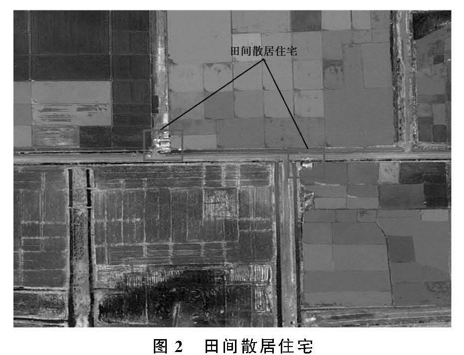
农村居民点作为农村社会的基本地域单元和基本聚落地,主要反映了在农业生产过程中人类对自然环境的适应,及对发展空间的干预、调整和重构[1]。长期以来,我国的农村居民点缺少系统的规划,在农村居民点建设与发展过程中,存在农户居住建设缺乏有效管理、住宅布局散乱、土地利用效率低下等一系列的问题[2-3],导致农村居民点空间格局出现失衡状态,加上农村居民点规模小,缺乏统筹规划,基础设施配套难,失衡的农村居民点空间格局给农村的生产、生活、生态带来不利的影响。随着近年来我国对农村居民点问题的认识加深,目前在全国范围内席卷而来一股农村居民点整治的热潮,我国的广大农村地区纷纷开展了农村居民点整治工作。当前我国北方平原地区农村居民点的集聚度有着不同程度的增强,同时农村居民点的形态也更趋于规则。但在黑龙江省农业现代化区域即垦区目前已分化出两类不同功能的农村居民点,分别为聚居态农村居民点与田间散居住宅。聚居态农村居民点整体规模较大内部公共基础服务设施完善可以大大提高农民日常生活中的幸福感与获得感,是服务农民日常生活的农村居民点; 田间散居住宅是由于当前的聚居态主要农村居民点无法满足现有的农业生产模式,农民为提高耕种效率在耕作时期用于农户暂时性居住的住宅。当前垦区多数农户同时拥有两类农村居民点,“一户两宅”必定将造成垦区人均建设用地的超标,降低土地利用的集约度。因此对黑龙江省农业现代化区域即垦区开展农村居民点空间布局优化研究,重构与当前垦区农业生产模式相匹配的农村居民点空间体系,对实现土地的高效与集约利用具有重要的意义。
目前众多学者对我国典型地形区和典型功能区进行了大量的乡村聚落空间布局优化调整和居民点内部村庄整理的研究。在对山地乡村聚落进行空间布局优化调整时,将农村居民点划分为保留居民点、迁移居民点和集聚居民点,通过村庄合并完成农村居民点空间布局调整[4]; 在对黄土丘陵区乡村聚落进行布局优化研究时,通过分析该区域内村庄的空间布局、动态变化特征和主要驱动因素,提出了城镇化整理型、集聚发展型和迁移型3种空间优化模式[5]; 在对厦门市村庄的空间分布演变进行分析时,提出乡村聚落空间结构优化调整方案,将乡村聚落用地划分为优势发展区、空间结构优化区、交通网络优化区、空间结构与交通网络优化区以及限制发展区,并提出相应的优化策略[6]; 通过对西南山区散居农村居民点的空间分布特征的分析,结合地形、交通、经济和耕地资源等影响因素,提出山区农村居民点规划应坚持“集中为主,分散为辅,散中有聚”的优化布局原则[7]; 在考察了厦门市马洋溪生态旅游区的“旅游吸引物、旅游小镇与乡村环境”三大空间载体在旅游城镇化进程中的空间异化和空间关联性,对旅游区提出整理方案,整理内容包括:确定保留的居民点和撤并的居民点并严格控制生态红线[8]; 在对河北省涞水县野三坡旅游区内村庄的生产、生活、生态3类空间进行分析时,提出通过突出地方文化特色、强化服务功能、加强生态景观建设等方法,提升村庄的旅游服务价值[9]。尽管已有研究为农村居民点的整治工作提供了大量的参考依据,但研究往往忽视微观层面的差异,存在农村居民点布局优化的盲目模仿和“一刀切”现象,研究成果对农村居民点布局优化实践的指导性不强,同时在布局优化的过程中也往往忽略了对农村居民点数量与规模的限定。
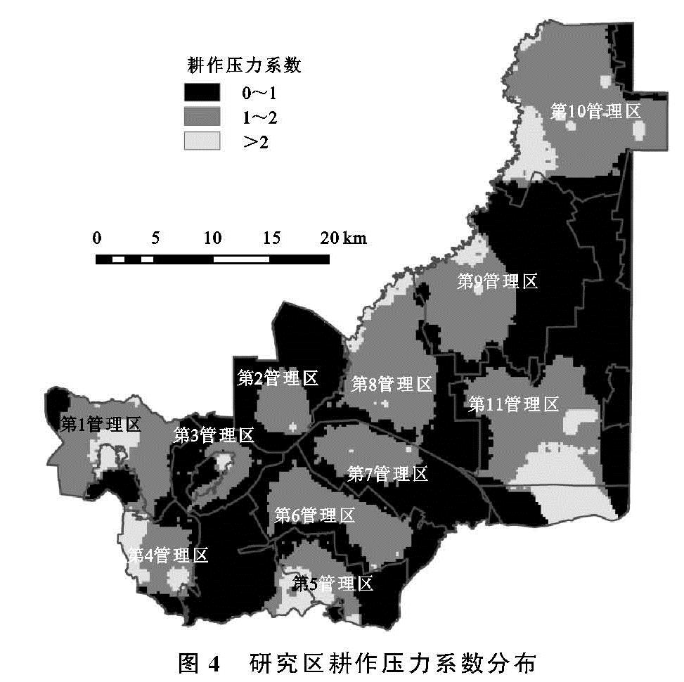
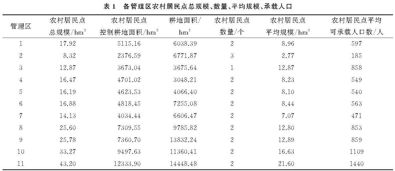
鉴于此,本文以黑龙江省农垦建三江管理局所辖八五九农场为研究区,八五九农场位于三江平原东部,其具有耕地面积大、机械化水平高等特点,是现代农业典型示范区与黑龙江省两大平原现代农业综合配套改革试验区,同时也为黑龙江省农场群中农业现代化和城镇化发展较快的农场之一。当前八五九农场内部同时拥有大规模聚居态农村居民点与田间散居住宅,并且散居住宅的数量较为庞大,为开展黑龙江省农业现代化区域农村居民点空间布局优化研究的典型区域。利用抚远市与饶河县2015年土地利用变更调查矢量数据库以及高分辨率遥感影像,采用空间分析、耕作压力系数与农村居民点规模预测模型相结合的方法,对八五九农场农村居民点进行空间布局调整,同时在保证集约利用建设用地的前提下确定各管理区农村居民点的数量、规模以及可承载的人口量,以期为我国广大农村地区开展农村居民点整治工作提供参考与借鉴。