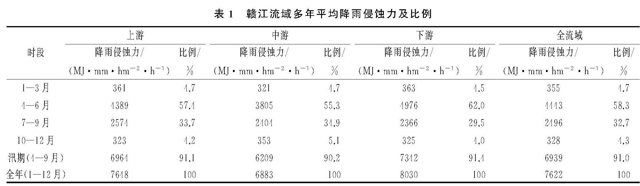
3.3.1 趋势性分析
流域面降雨侵蚀力由站点降雨侵蚀力的算术平均计算,为分析流域月降雨侵蚀力变化,将1958—2014年分为5个时段:1958—1970年、1971—1980年、1981—1990年、1991—2000年、2001—2014年。由图4可知,赣江流域月降雨侵蚀力最大月份为6月,平均值为2 217(MJ·mm)/(hm2·h),其次为5月份,最小月份为1月,平均值为15(MJ·mm)/(hm2·h),极值相差近150倍,年内月降雨侵蚀力分布极不均匀。相同月份5个时段间变化有所差别,月降雨侵蚀力最大的4个月(5月、6月、7月和8月)占年降雨侵蚀力的75%,注重降低5月至8月水土流失风险,对于全年赣江流域水土保持具有重要作用。选取最大的4个月为典型,运用线性回归分别对其进行趋势分析,见图5可知,5月和6月没有趋势变化,7月和8月份有上升趋势,尤以7月变化较明显。
从4个季度来看,5个时段的主汛期(4—6月)降雨侵蚀力占全年比重均在50%以上,最小比重时段(1991—2000年)降雨侵蚀力为4 389 MJ·mm/(hm2·h),占全年比例为53.3%,最大比重时段(1958—1970年)降雨侵蚀力为4 691(MJ·mm)/(hm2·h),占比达62.5%; 汛期(4—9月)降雨侵蚀力占全年比重89.4%~91.6%,与流域河道输沙时段基本一致; 年降雨侵蚀力最大时段为1991—2000年,约为8 234(MJ·mm)/(hm2·h),其次为2001—2014年,最小时段为1981—1990年,约为6 995(MJ·mm)/(hm2·h)。
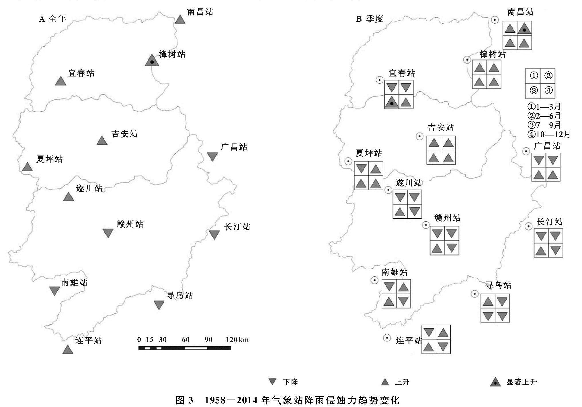
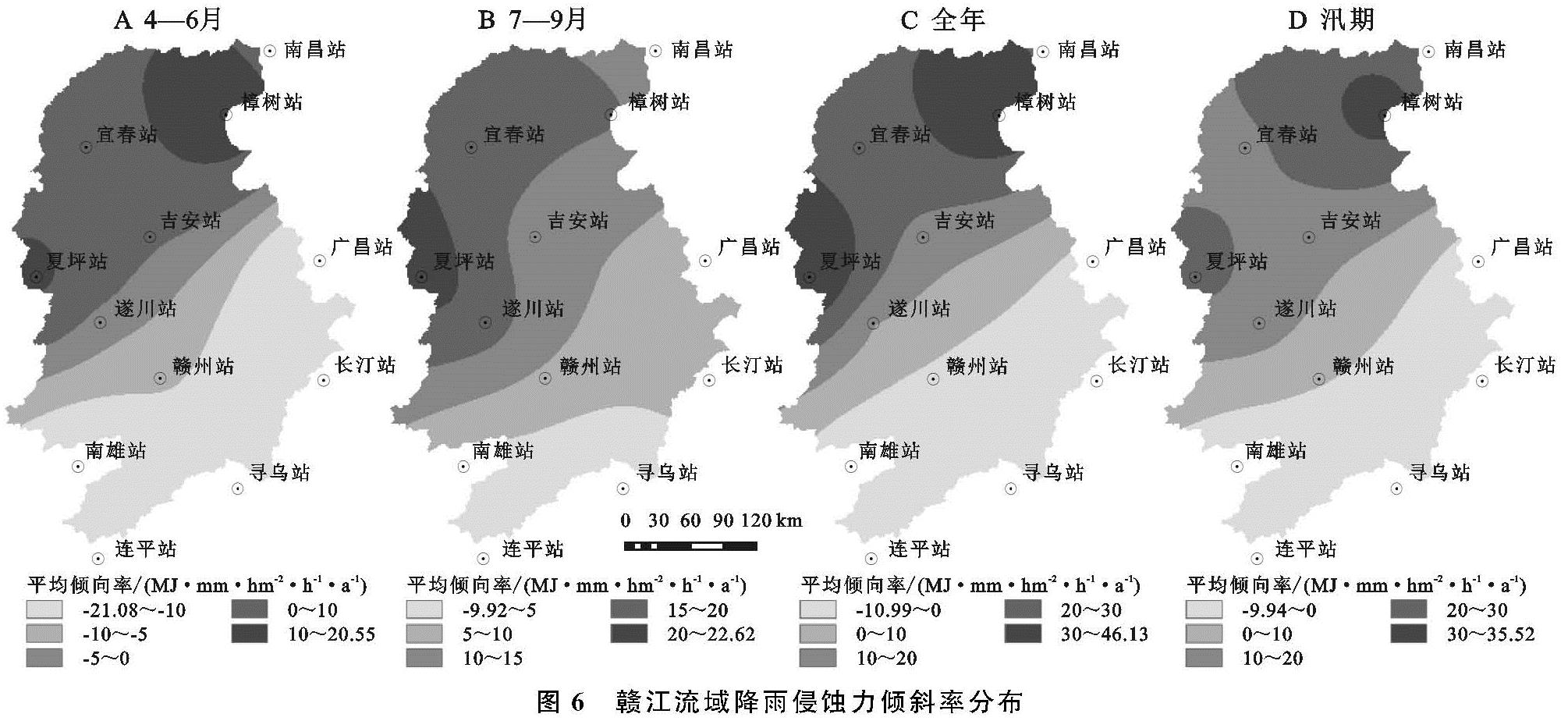
与站点分析类似,运用TFPW-MK法分析流域面降雨侵蚀力趋势,结果见表3和图6。赣江流域降雨侵蚀力变化存在明显的空间差异,年降雨侵蚀力倾斜率β变化范围0.718~34.707(MJ·mm)/(hm2·h),整体上上游区变化较小,中下游上升趋势较明显,其中最大变化点位于樟树站和夏坪站。
对于年降雨侵蚀力,全流域上升了588.639(MJ·mm)/(hm2·h),多年倾斜率β为12.250(MJ·mm)/(hm2·h)。对于上中下游而言,上游年降雨侵蚀力略有上升,而中游和下游上升趋势较明显,倾斜率β分别为28.505(MJ·mm)/(hm2·h),34.707(MJ·mm)/(hm2·h),其中下游上升趋势显著(p<0.05)。汛期(4—9月)降雨侵蚀力上升趋势较明显,多年倾斜率β为9.587(MJ·mm)/(hm2·h)。
对于季度降雨侵蚀力,流域除10—12月有下降,其他3个季度为上升趋势,其中7—9月上升最快且具有显著性(α=0.05),多年倾斜率β为12.481(MJ·mm)/(hm2·h)。
此外,主汛期(4—6月)整体分布与全年基本一致,但较全年降雨侵蚀力下游上升幅度变小,而上游区则下降速率变大。对于上中下游而言,中下游在4个季度均为上升趋势,且下游在7—9月呈上升趋势显著(p<0.05),上游在1—3月和7—9月呈上升趋势,4—6月和10—12月呈下降趋势。
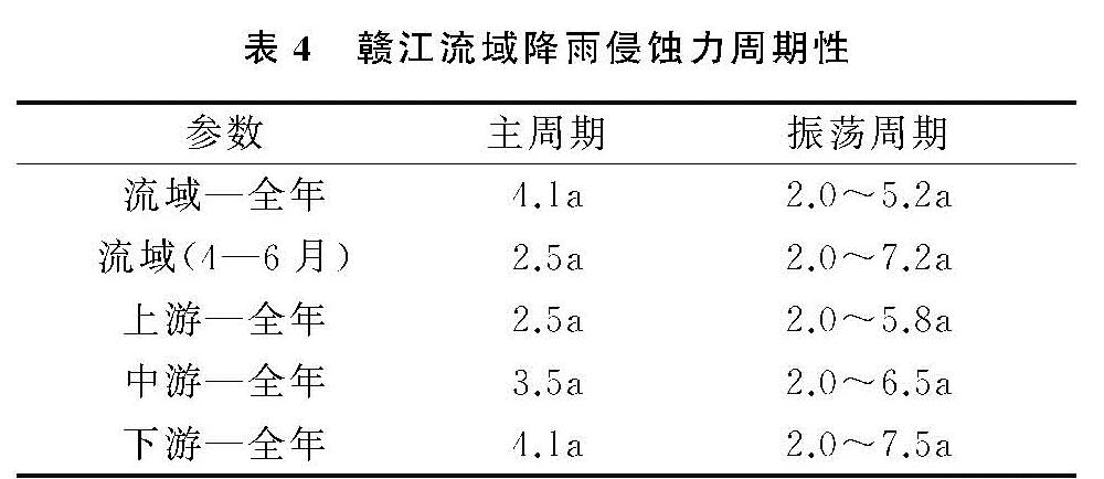
3.3.2 周期性分析
针对全流域和上中下游的年降雨侵蚀力序列,本文运用小波分析,通过小波方差图分析序列的主要周期成分和周期振荡,结果见表4,流域年降雨侵蚀力主周期为4.1 a,振荡周期为2.0~5.2 a,在上中下游3个区域中,上游主周期和振荡幅度均最小,分别为2.5 a和2.0~5.8 a,下游主周期和振荡周期幅度为最大。此外,主汛期(4—6月)分析结果表明,流域降雨侵蚀力主周期为2.5 a为,振荡周期为2.0~7.2 a,与流域年降雨侵蚀力周期特性有一定差别。在土地开发利用中,针对不同区域的周期性特点,在降雨侵蚀力高值时段加强水土保持设施的维护,降低山区丘陵区土壤扰动,可有效地提升水土保持管理成效。
以流域年降雨侵蚀力为例,赣江流域降雨侵蚀力具有较明显的多周期嵌套、强弱交替出现的特征。在1958—2014年年降雨侵蚀力序列存在2.5,4.1,6.9,11.7,23.4 a的周期,其中仅有2.5,4.1 a周期通过了95%的红噪声检验。4.1 a周期对应的小波方差峰值较2.5 a的高,表明4.1 a为该序列的主周期。在连续小波变换图中,能量密度的峰值主要集中在1960—1965年、1970—1976年、1962—1978年、1984—1998,2000—2008年5个时段。其中,1960—1965年、1970—1976年和2000—2009年分别以2.0~4.2 a,2.0~3.8 a,2.0~5.2 a为显著周期,并均通过红噪声检验。此外,1962—1978年、1984—1998年存在7.0~7.4 a和21~27 a的变化周期,但没有通过红噪声检验。因此,流域年降雨侵蚀力主周期为4.1 a为,振荡周期为2.0~5.2 a。
3.4 讨 论
降雨侵蚀力受侵蚀性降雨影响显著,赣江流域多年平均降雨侵蚀力7 272.6(MJ·mm)/(hm2·h),低于鄱阳湖流域多年平均降雨侵蚀力[15],与周边相比,高于湖南省,低于安徽、福建、广东等东南省区[12],这与所处的气候条件不同有关。赣江流域10—12月降雨侵蚀力呈下降趋势,但全年略有上升趋势,主要是由于7—9月降雨侵蚀力上升趋势显著导致(α=0.05)。此外,月降雨侵蚀力主要集中4—6月,且无显著性变化,建议加强水土流失防治,同时警惕7—9月因降雨侵蚀力增强而导致的水土流失增加的风险。
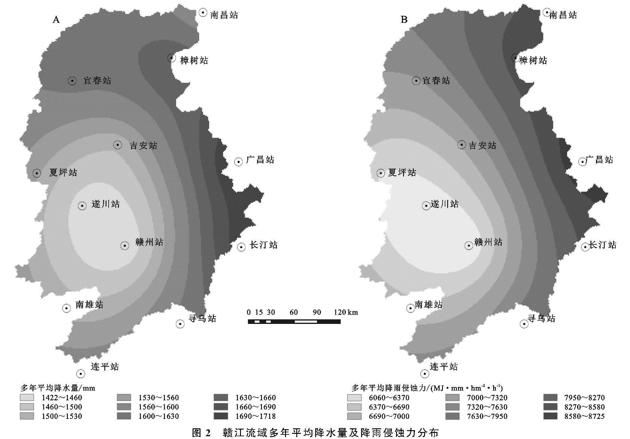
赣江流域降雨侵蚀力空间上与鄱阳湖流域类似,自东向西逐渐增加,南北方向差异较小,东西方向仍是引起赣江降雨侵蚀力变化的地理主轴,也进一步表明降雨侵蚀力受沿东南登陆的台风型降雨影响明显。赣江流域土壤侵蚀严重区较为集中在上游区(即赣南地区),但上游区年降雨侵蚀力略有下降,一定程度上有利于赣南水土流失治理; 赣江中下游区为人类活动较为强区域,降雨侵蚀力上升趋势较为明显,需进一步强化公众的水保意识,提高区域的水土保持措施。