2.1.1 不同海拔土地利用空间分布
由附图14可知,耕地主要分布在海拔<3 700 m区域,尤其集中在2 700~3 200 m区域,1980年、1990年、2000年、2010年、2018年此区域耕地面积占研究区的比例分别为2.18%,2.18%,2.16%,2.33%,2.31%,集中分布在大通河以北的门源盆地,耕地集中连片,破碎度小。3 200~3 700 m区域林地面积最大,主要分布在东南部耕地的外围山地。3 700~4 200 m草地面积占研究区的比例最大,1980—2018年此区域草地面积占研究区的比例呈先升后降的趋势,主要集中在西北部山地,包括央隆乡、野牛沟乡和木里镇等。水域主要分布海拔3 200~4 200 m区域,占比由1980年的2.10%降低为2018年的1.88%,分布较为分散。55%左右的建设用地集中在2 700~3 200 m区域,占比由1980年的0.12%上升为2018年的0.14%,集中分布在门源县城驻地浩门镇北部地区,城镇建设用地占主导地位。3 700~4 700 m区域分布有近90%的未利用土地,占比整体呈上升趋势,主要分布在走廊南山、托勒山、托勒南山和冷龙岭山地。
2.1.2 不同坡度土地利用空间格局
由附图15可知,74%左右耕地分布在坡度<10°区域,其中50%集中在坡度<5°区域,集中分布在门源盆地。34%左右的林地集中分布在坡度10°~20°的区域,以坡度15°为界,<15°区域林地面积随坡度增加而增加,>15°区域林地分布则呈相反趋势,林地分布呈现整体分散,局部集中的分布格局,其中坡度10°~15°的黑河南岸的山地林地面积分布较为集中。草地面积随坡度增加呈减少趋势,主要集中在西北部地区,其分布与山地走向大致一致。水域呈整体分散,居中集中的格局,坡度<5°区域水域面积占全部水域面积的比重逐渐扩大。56%左右的建设用地主要集中在坡度<5°区域,研究时段内建设用地整体呈增加趋势,青海湖农场、伊克乌兰乡和哈尔盖镇分布较为集中。坡度<30°区域未利用土地面积在不同坡度上的分布比例差异较小。
2.1.3 不同坡向土地利用空间格局
由附图16可知,近40%的耕地分布在南坡和西南坡,即阳坡和半阳坡。林地主要分布在北坡、东北坡、西坡和西北坡,走向大致呈西北—东南走向,托勒山和冷龙岭分布集中。近26%的草地分布在西坡和西南坡,其中西坡的草地整体呈增加趋势,走廊南山和托勒山分布较为明显,而西南坡的草地整体呈降低趋势。水域和未利用土地在不同坡向的分布比例差异较小,分布较为分散。近35%的建设用地分布在南坡和西南坡,主要集中在浩门镇和木里镇,建设用地分别来自县城建设和矿区建设。
2.2 不同海拔、坡度和坡向土地利用数量变化
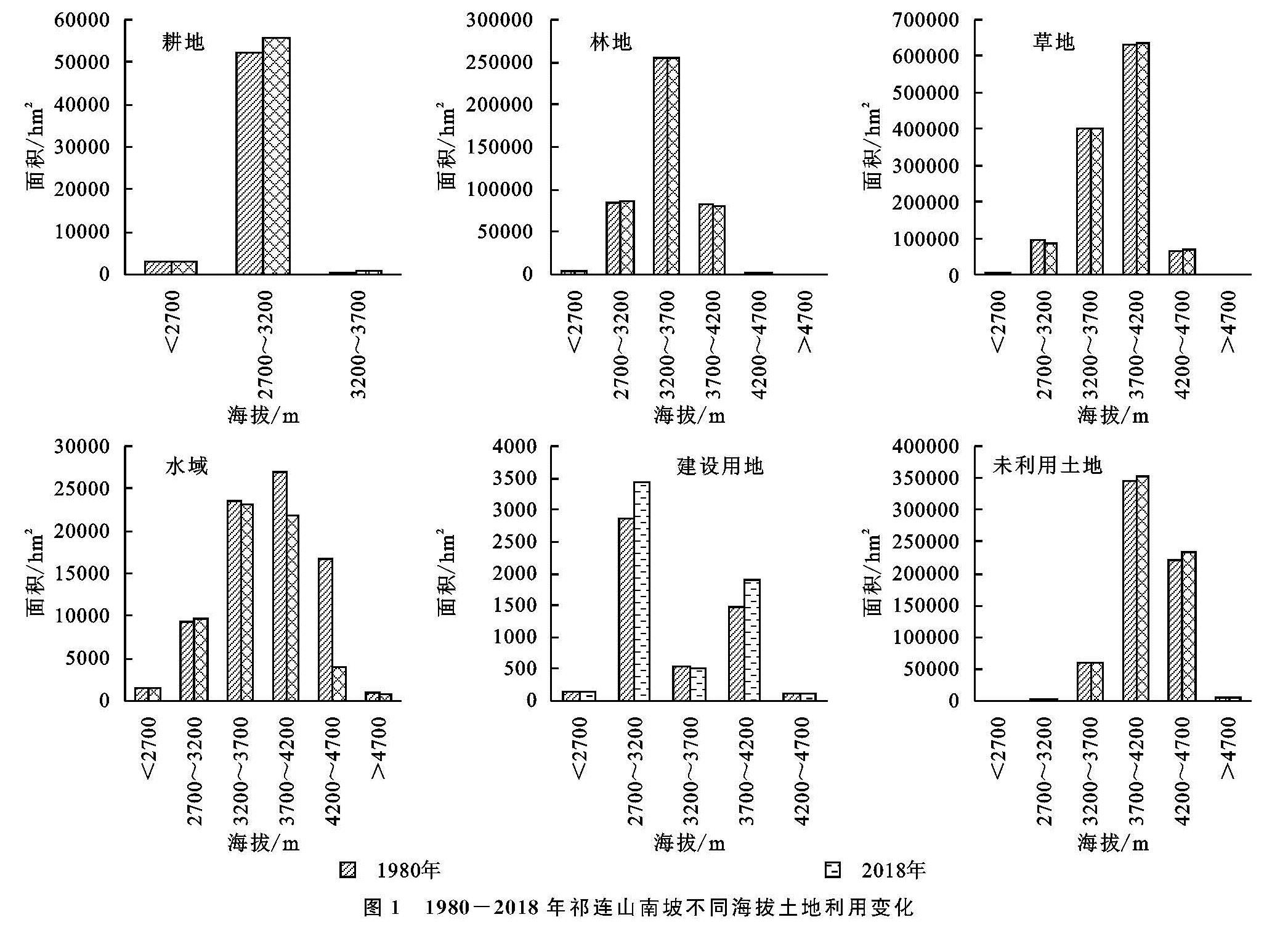
2.2.1 不同海拔土地利用数量变化
由图1可知,耕地仅分布在海拔<3 700 m的区域,其中以海拔2 700~3 200 m区域为主,2018年此区域耕地面积达55 537.83 hm2,占耕地总面积的93.29%,1980—2018年耕地面积共增加了3 690.18 hm2,其中此区域耕地面积增加最大,达3 290.31 hm2。海拔3 200~3 700 m林地面积最大,2018年达254 386.26 hm2,占林地总面积的59.47%,林地面积从3 700 m分别向高、低海拔区域逐渐减少,从变化来看,1980—2018年海拔>3 700 m区域的林地面积为增加趋势,其中4 200~4 700 m区域林地面积增加最多,达2 154.60 hm2。草地以4 200 m为界,面积分别向高、低海拔逐渐减少,草地的变化趋势以3 700 m为界,<3 700 m草地呈减少趋势,>3 700 m区域为增加趋势。水域面积随海拔升高呈先增后减趋势,1980—2018年,水域面积整体减少18 237.10 hm2,其中4 200~4 700 m区域水域减少面积是水域减少总面积的70.73%。除>4 700 m区域无建设用地分布,其余海拔均有分布,分布规律呈“M”型,2 700~3 200 m和3 700~4 200 m区域建设用地面积增长较快,分别增加568.71,412.56 hm2。2018年,3 700~4 700 m区域未利用土地面积达584 913.51 hm2,占未利用土地总面积的89.63%,以3 200 m为界,未利用土地在<3 200 m区域为减少趋势,>3 200 m区域为增加趋势,其中4 200~4 700 m区域增加最大,达11 559.87 hm2。
图1 1980-2018年祁连山南坡不同海拔土地利用变化
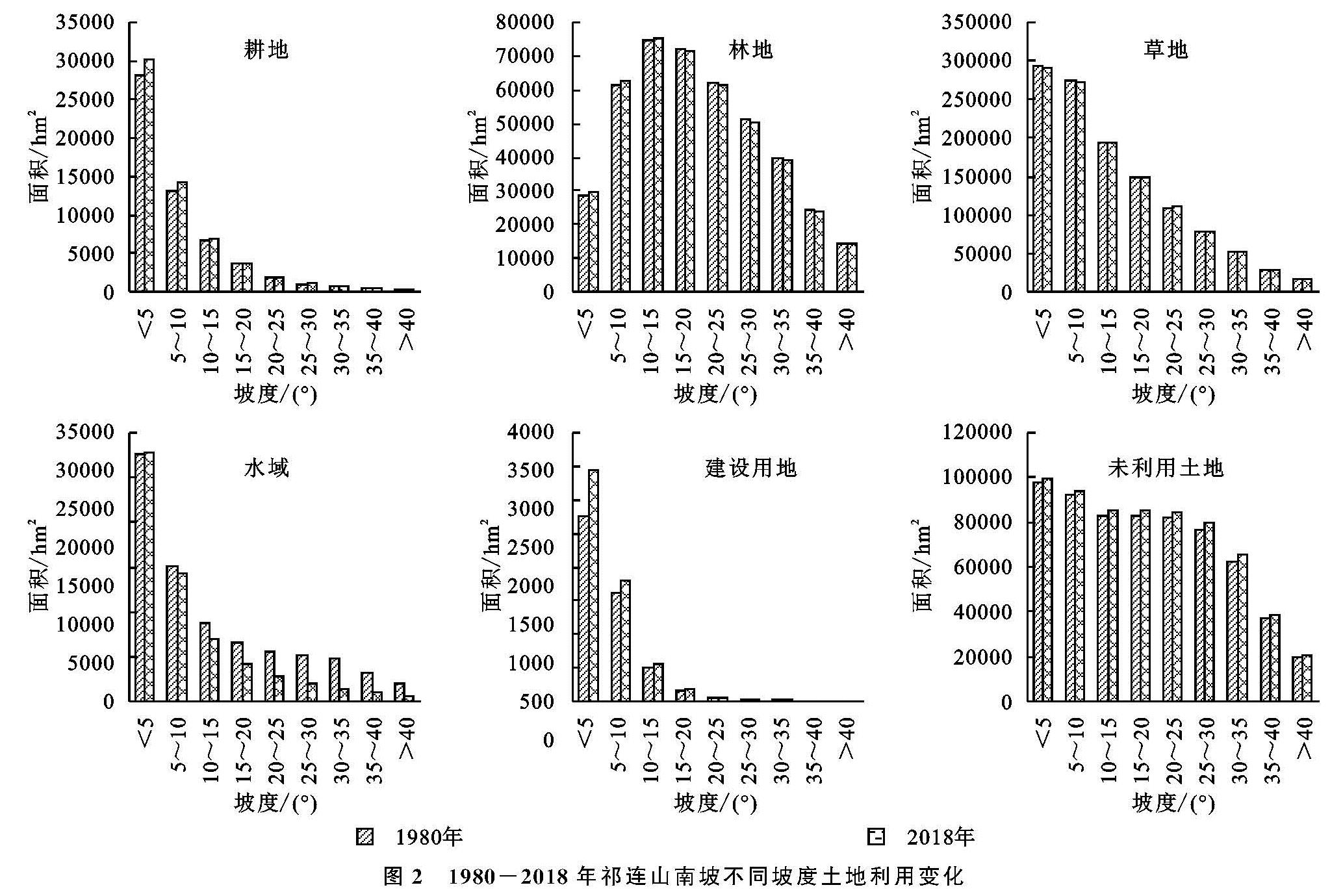
2.2.2 不同坡度土地利用数量变化
由可图2可知,耕地面积随坡度增加呈降低趋势,坡度<5°耕地分布面积最大,2018年达30 119.94 hm2,占耕地总面积的50.59%,1980—2018年各坡度上耕地面积均有所增加,其中坡度<5°区域增加最大,达2 063.07 hm2。林地面积由大到小分布的坡度依次为10°~15°,15°~20°,5°~10°,20°~25°,25°~30°,30°~35°,<5°,35°~40°和>40°,坡度10°~15°林地面积最大,2018年达75 013.29 hm2,1980—2018年,坡度<15°和>40°林地面积呈增加趋势,其余坡度林地面积均为减小态势,其中坡度5°~10°林地面积增加最大,达1 224.36 hm2。草地面积随坡度增加呈减小趋势,坡度<5°草地面积最大,从变化看,坡度<15°草地面积表现出缩减态势,坡度<5°草地面积缩减最大,达4 644 hm2,而坡度>15°草地面积呈扩大态势,其中坡度20°~30°草地面积扩大了3 003.39 hm2。水域面积随坡度增加也呈减小趋势,2018年,坡度<5°水域面积达27 738.63 hm2,坡度>40°水域面积仅为679.77 hm2,1980—2018年,除了坡度<5°的水域面积为增加趋势,其余坡度水域面积均为减小趋势。建设用地面积随坡度增加呈递减趋势,坡度<5°建设用地面积最大,2018年为3 439.17 hm2,1980—2018年,坡度<30°建设用地面积表现出增加趋势,其中坡度<5°增加面积最多,达687.06 hm2,占建设用地增加面积的71.44%。随坡度增加未利用土地面积整体表现出降低趋势,未利用土地面积在不同坡度均有所增加,其中坡度30°~35°增加最大,达2 816.55 hm2。
2.2.3 不同坡向土地利用数量变化
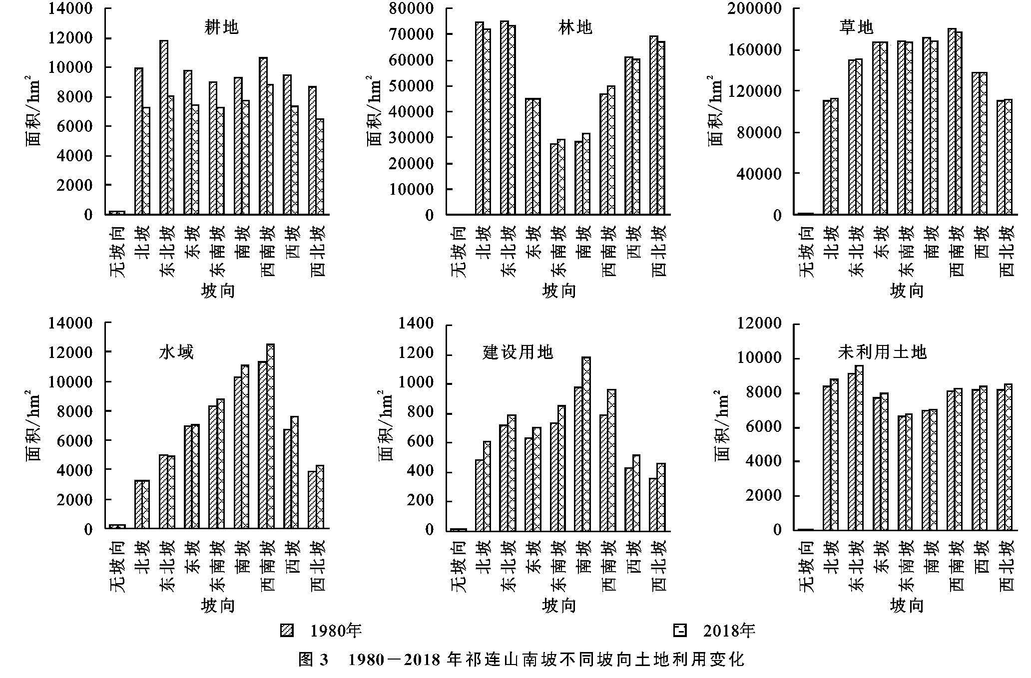
由图3可知,西南坡耕地面积分布最多,2018年达12 462.03 hm2,除了东北坡耕地面积有所减少,其余各坡向均在扩大,西南坡耕地扩大最大,达1 170.36 hm2,从北坡按顺时针方向旋转耕地面积呈先增后减态势,西南坡增加最大,之后减小,西南坡和南坡扩大面积之和比其余坡向扩大的面积之和还多256.14 hm2,说明耕地主要集中在阳坡和半阳坡且在此坡向增加的面积最多。林地在北坡、东北坡和西北坡分布面积较大,2018年共212 230.89 hm2,占林地总面积的49.62%,东南坡和南坡林地分布较少,面积仅占林地总面积14.18%,说明林地主要集中在阴坡和半阴坡; 北坡、东北坡、西坡和西北坡的林地面积为减少趋势,东坡、东南坡、南坡和西南坡的林地面积为增加趋势,说明林地面积在阴坡和半阴坡为减少状态,在阳坡和半阳坡为增加状态。草地在西南坡分布面积最大,2018年达176 854.68 hm2,和耕地、林地相比,草地在各个坡向上分布差异较小; 1980—2018年草地在坡向上的变化与林地相反,北坡、东北坡、西坡和西北坡草地面积为增加趋势,东坡、东南坡、南坡和西南坡的草地面积为减少趋势,说明林地面积在阴坡和半阴坡处于增加状态,在阳坡和半阳坡为减少状态。水域在东北坡和西南坡分布面积较广,分别达8 060.31,8 835.57 hm2,除了无坡向,其余坡向的水域面积均有所下降,其中东北坡的水域面积下降最大,为3 782.16 hm2。南坡的建设用地面积最大,2018年达1 182.15 hm2,西南坡的建设用地面积次之,为963.72 hm2,建设用地面积在每个坡向上均有所增加,其中南坡增加最大,达207.18 hm2,说明阳坡的建设用地面积最大且增加最快。东北坡和北坡较其他坡向的未利用土地面积大,二者面积之和达183 536.46 hm2,占未利用土地总面积28.12%,每个坡向上未利用土地面积均呈增加态势,其中东北坡增加最大,达4 794.66 hm2。
图2 1980-2018年祁连山南坡不同坡度土地利用变化
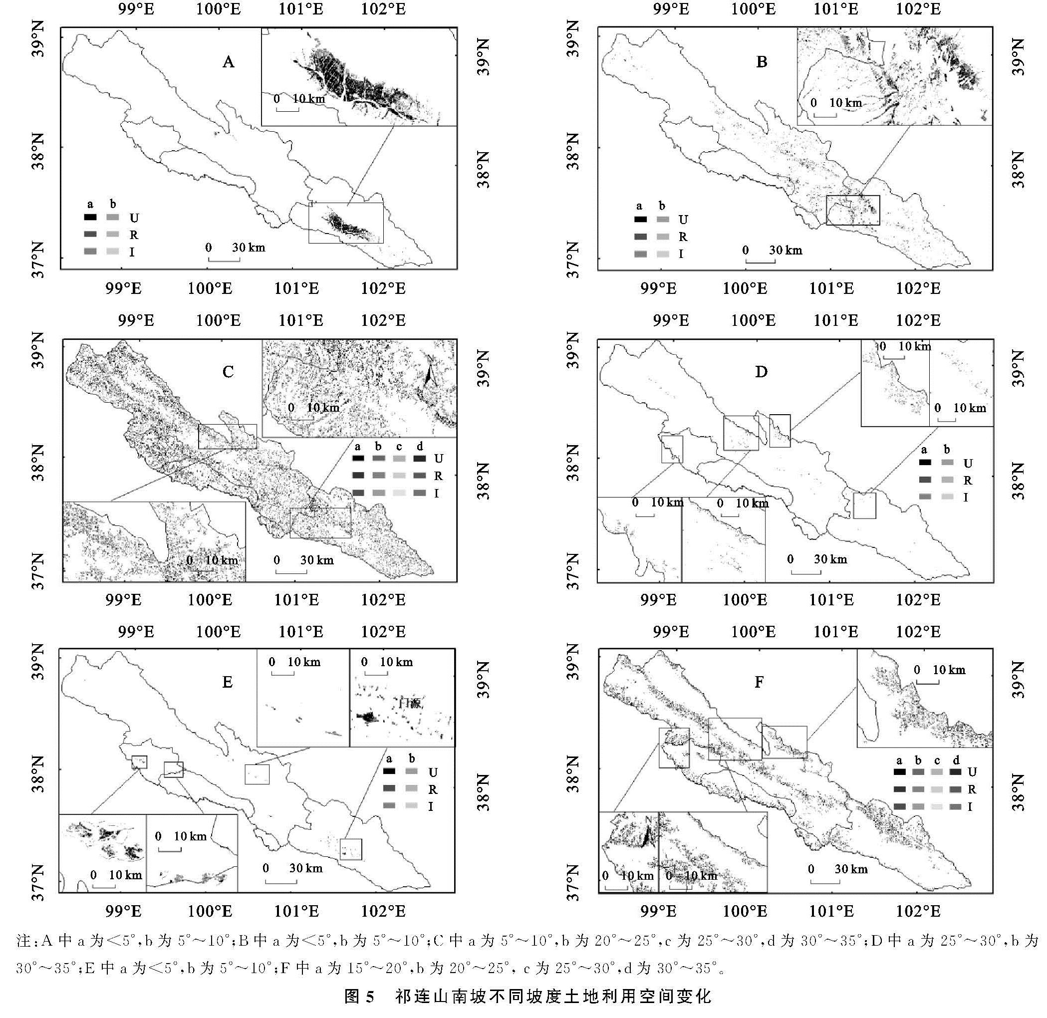
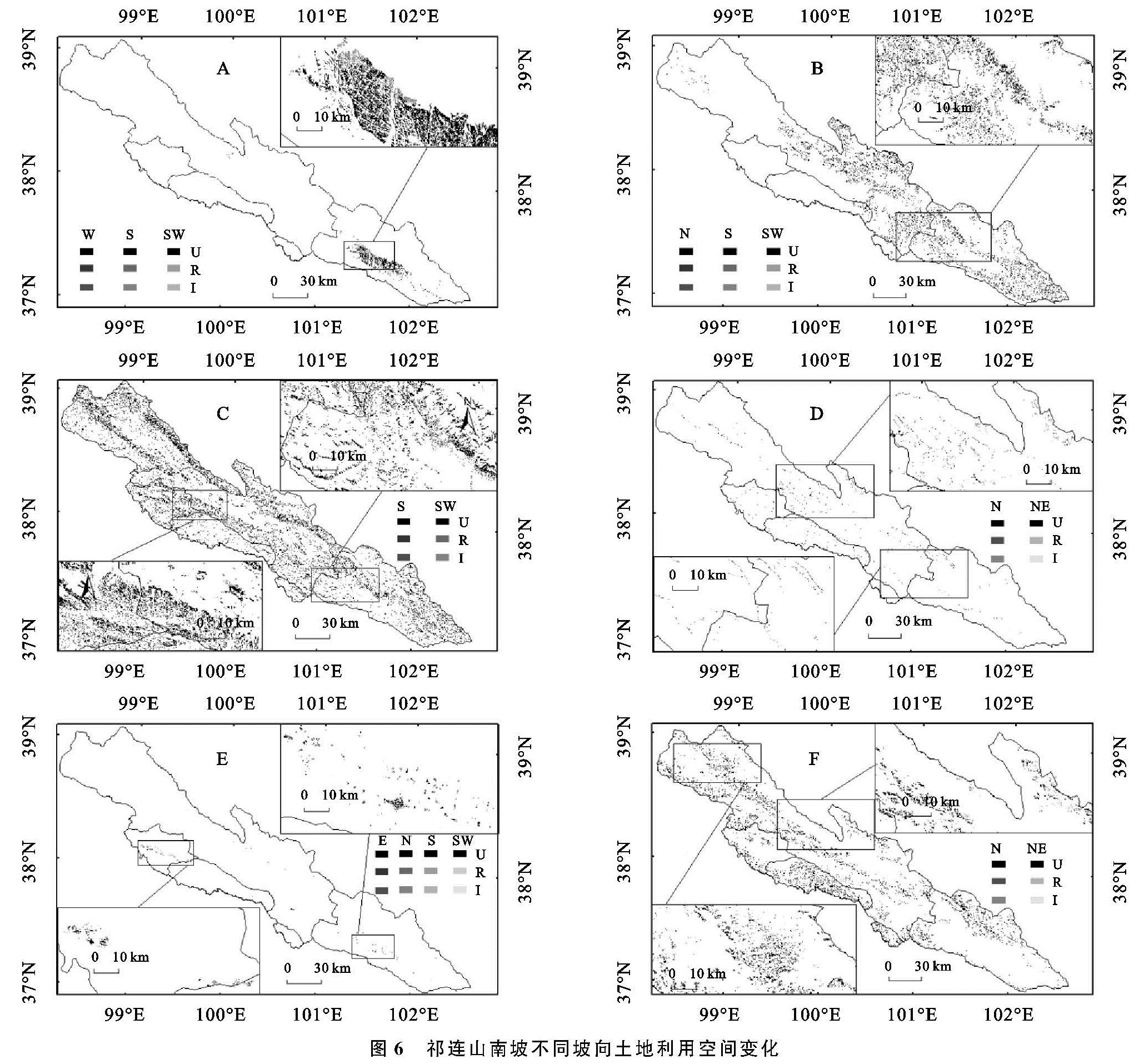
2.3 不同海拔、坡度和坡向土地利用空间变化
2.3.1 不同海拔土地利用空间变化
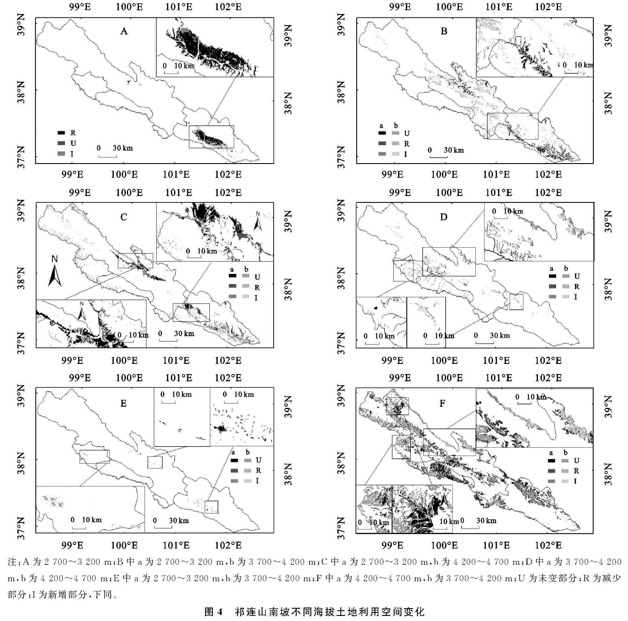
由图4可知,耕地在海拔2 700~3 200 m变化最大,增加了3 290.31 hm2,增加的区域主要分布在门源种马场的东南部和北山乡的中部,门源县县城驻地浩门镇的北部耕地面积减少较为集中。3 700~4 200 m林地面积变化最大,减少了1 625.8 hm2,默勒乡和苏吉滩乡交界处减少面积较为集中; 海拔2 700~3 200 m林地增加了1 285.2 hm2,新增的林地面积主要集中在门源种马场和苏吉滩乡的交界处。草地在海拔2 700~3 200 m减少达5 244 hm2,主要集中在种马场的东部和西南部,在海拔4 200~4 700 m增加2 154.6 hm2,增加的区域主要为默勒乡和苏吉滩乡交界处。水域面积在海拔3 700~4 700 m减少了17 916.2 hm2,减少区域集中在八宝镇的北部、扎麻什乡的西部和北部、野牛沟乡的东北部。建设用地在海拔2 700~3 200 m增加568.71 hm2,在海拔3 700~4 700 m增加412.56 hm2,新增的面积集中在浩门镇北部、北山、西滩、泉口的南部和峨堡镇西部,木里镇和吉尔孟乡的交界处建设用地减少较多。海拔3 700~4 700 m未利用土地共增加17 371.17 hm2,在八宝镇的北部、扎麻什乡的西部和北部、野牛沟乡的东北部和野牛沟乡西北部增加面积较为集中。
图3 1980-2018年祁连山南坡不同坡向土地利用变化
2.3.2 不同坡度土地利用空间变化
坡度<5°耕地新增最多(图5),新增区域主要分布在门源种马场东南部,坡度5°~10°新增的耕地面积主要分布在北山乡中西部。坡度<5°和5°~10°林地面积增加了2 010.87 hm2,门源种马场、苏吉滩乡和默勒镇3个乡镇交界地带的林地变化明显。坡度5°~10°草地面积减少3 031.02 hm2,主要分布在门源种马场东南部及其与北山乡、苏吉滩乡的交界处,坡度30°~35°草地面积新增区域集中在扎麻什乡的中西部。坡度25°~35°水域面积减少最集中,共减少3 342.2 hm2,集中在扎麻什乡北部和中西部、野牛沟乡、八宝镇东北部、木里镇西南部和皇城乡西北部。坡度<5°建设用地面积增加最大,达687.06 hm2,主要集中在浩门镇北部、木里镇、吉尔孟乡和峨堡镇西部。坡度15°~35°未利用土地共新增10 108.08 hm2,八宝镇东北部、扎麻什乡北部和野牛沟乡东北部变化较为集中。
2.3.3 不同坡向土地利用空间变化
由图6可知,西南坡耕地面积新增最多,西坡和南坡增加次之,主要集中在门源种马场东南部和北山乡中西部。南坡和西南坡林地面积分别增加了3 089.88,3 030.75 hm2,北坡减少了2 692.20 hm2,门源种马场、苏吉滩乡和默勒镇附近变化较大。西南坡和南坡的草地分别减少了3 003.4,2 790.9 hm2,主要集中在北山乡中西部、种马场东南部和西南部,草地增加区域位于默勒镇东部边缘和扎麻什乡中西部。东北坡和北坡水域面积分别减少3 782.2,2 671.5 hm2,其中减少的区域主要集中在八宝镇的东北部、扎麻什乡和皇城乡,新增面积集中在种马场、苏吉滩乡和默勒镇的交处。各个坡向建设用地面积均有增加,其中南坡增加面积最大,达207.18 hm2,西南坡增加了176.49 hm2,增加较大的乡镇为浩门镇、北山乡、西滩乡、泉口镇和木里镇与吉尔孟乡交界处。东北坡和北坡未利用土地面积增加最大,分别达4 794.65,3 682.53 hm2,新增面积主要集中在八宝镇北部和扎麻什乡中北部,减少面积主要集中在央隆乡和野牛沟乡西北部。
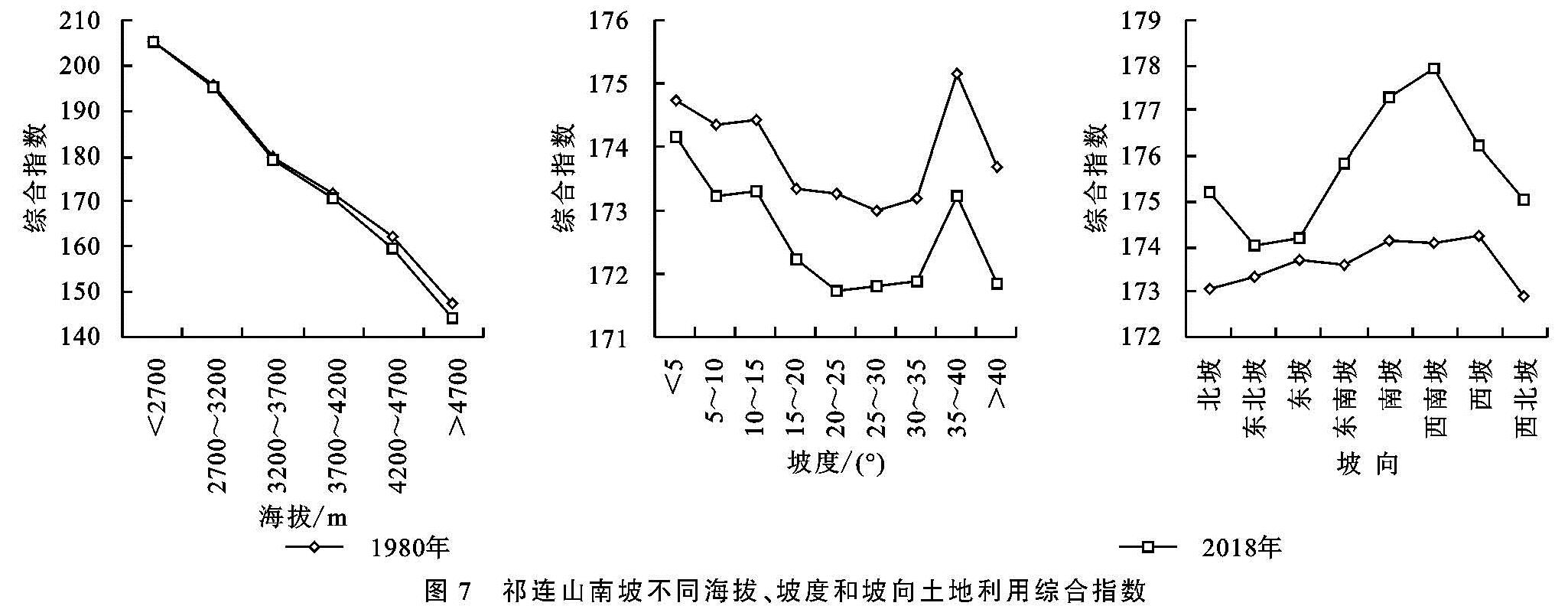
2.4 不同海拔、坡度和坡向土地利用程度变化
由图7可知,土地利用综合指数随海拔升高呈降低的趋势,随坡度增加整体呈先降后增又降的态势,坡度35°~40°处为最大值,2018年不同海拔、坡度上土地利用综合指数较1980年均略有下降。不同坡向上综合指数从北坡按顺时针方向旋转整体呈先增后减趋势,2018年不同坡向上土地利用综合指数较1980年均有上升。
2.5 地形因子地理探测
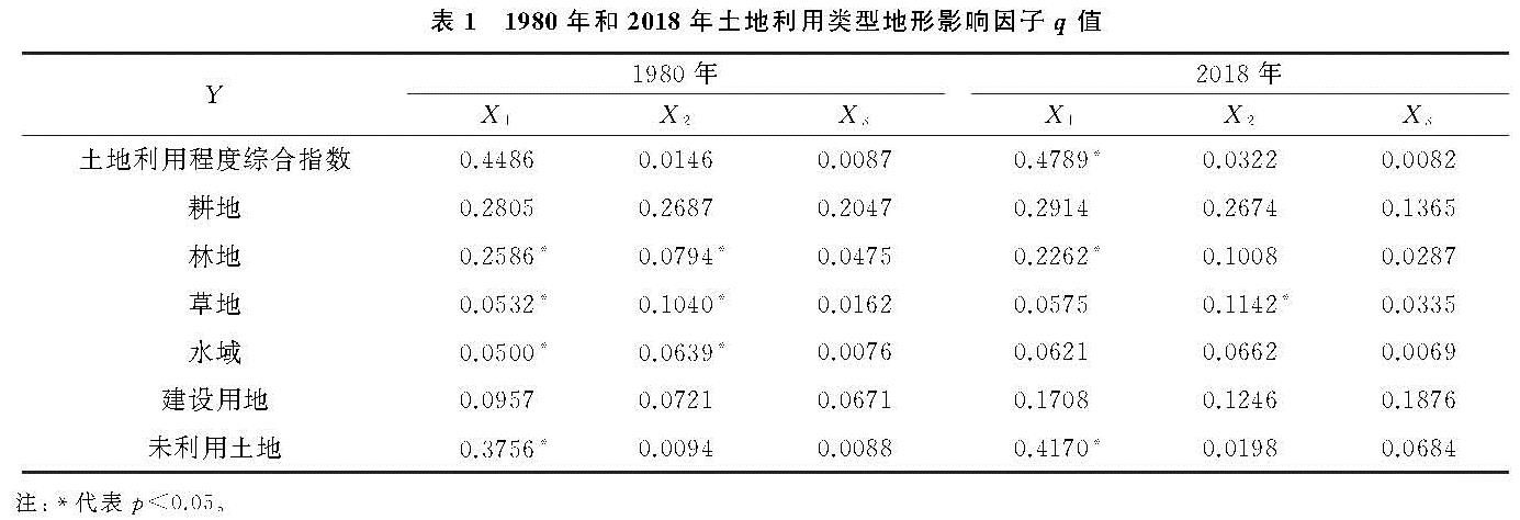
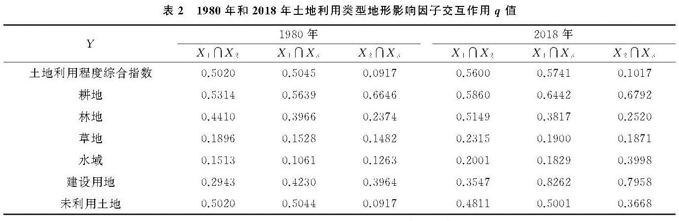
因子探测分析表明(表1—2),1980年和2018年地形因子对土地利用程度综合指数影响程度由大到小依次为海拔、坡度和坡向,说明海拔对土地利用程度解释力最强,而坡向则解释不显著。交互探测结果显示,海拔和坡度、海拔和坡向对土地利用程度影响大,而坡度和坡向则影响小。从q值可得,地形因子对不同土地利用类型的影响存在差异,海拔、坡度和坡向对耕地均有影响,研究区内约93%和51%的耕地集中在海拔2 700~3 200 m和坡度<5°区域内,耕地分布以阳坡和半阳坡分布为主,主要因为海拔低,水热条件更能满足农作物的种植和生长; 坡度>25°时,因水土流失严重,土壤养分流失,不仅不适宜发展耕地,而且加剧水土流失,造成生态环境破坏,但坡度>25°区域仍然存在约4%的耕地,故应该退耕还林还草; 阳坡和半阳坡光照能满足农作物的生长。交互探测结果表明,任意两种因子交互影响均比单个因子影响大。海拔对林地的影响最大,q值分别为25.86%,22.62%,林地近60%集中在海拔3 200~3 700 m,此海拔区域既是山地迎风坡降水多的区域,同时也是受到人类活动干扰较少的区域,故林地在此海拔区域分布较广。交互探测对林地的影响程度由大到小依次为:海拔和坡度>海拔和坡向>坡度和坡向。由q值分析可得,坡度对草地影响最大,之后为海拔、坡向,53%的草地分布在海拔3 700~4 200 m区域,此区域相对于3 200~3 700 m区域降水减少,水分降低,植被由林地变为草地,也和人为干扰少有关,坡度>10°的草地减少面积随坡度增大呈降低趋势,坡度越大,人为干扰因素较少。交互探测结果和林地相似。海拔和坡度对水域影响大,坡向影响小,任意两种因子交互影响均比单个因子影响大。通过q值可知,海拔、坡度和坡向对建设用地均影响较大,且2018年比1980年影响程度增强,q值分别由1980年的9.57%,7.21%,6.71%增大到2018年的17.08%,12.46%,18.76%,建设用地在海拔、坡度和坡向上受到人类活动的干扰不断增强。海拔较低、坡度较小、阳坡和半阳坡人类活动干扰程度大,建设用地面积大。任意两种因子交互影响均比单个因子影响大。海拔对未利用土地的影响最大,近90%的未利用土地分布在海拔3 700~4 700 m的区域,研究区内未利用土地包括沙地、裸土地、裸岩石质地等,许多未利用土地是由草地退化或冰川消退形成,故未利用土地分布在高海拔地区,受海拔影响大。
图7 祁连山南坡不同海拔、坡度和坡向土地利用综合指数
3 讨论与结论
3.1 讨 论
通过分析可知海拔>3 700 m区域无耕地分布,说明海拔对耕地的影响最大; 随坡度增大耕地分布逐渐收敛,说明坡度对耕地分布较为明显,结论与臧玉珠等[11]的研究结论一致; 耕地集中分布在阳坡和半阳坡,与前人研究结论基本一致[25]。综合来看这些区域耕地分布较为集中,因为海拔较低、热量充足,坡度小,土壤水分易被保持,土壤肥力不易流失,阳坡和半阳坡,光照充足区域,容易发展种植业,加上人类活动行为在此区域较为频繁,土地易受到干扰,耕地和建设用地分布集中。林地和草地在海拔上的分布规律存在异同点,相同的是林草地均存在主要高海拔分布区域,不同的是林地和草地分布的最高海拔范围不同,分别为3 200~3 700 m和3 700~4 200 m,并且分布规律分别向高海拔和低海拔递减,说明海拔对林草地分布影响大; 冀西北林地主要集中在海拔>900 m的区域[26],与本区域的林地集中的海拔范围3 200~3 700 m有差异,主要因为两个研究区所处的气候基带和山地海拔不同。草地分布与坡度关系密切,坡度愈大草地面积愈小,这和坡度对井冈山草地的影响的结论有差异[11],这与祁连山南坡的气候、土壤等有关,祁连山南坡降水量不如井冈山地区多,土壤的含水量比井冈山地区少,所以祁连山南坡地区坡度愈大,土壤含水量少,植被生长条件变差,草地分布面积愈少。林草地与坡向的关系大致相反,林地面积的分布以北坡、东北坡、西坡和西北坡为主,即以阴坡和半阴坡为主,草地面积的分布以西南坡、南坡、东南坡和东坡为主,即以阳坡和半阳坡为主,此结论与前人的研究成果基本一致[23]。海拔2 700~3 200 m,3 700~4 200 m和坡度<5°区域的建设用地分布面积较多,说明建设用地受海拔和坡度影响大,2 700~3 200 m区域建设用地以城镇和农村建设为主,3 700~4 200 m区域建设用地以山区矿区建设为主,坡向对建设用地影响小。未利用土地受到海拔影响明显,坡度和坡向对未利用土地影响较小。
表1 1980年和2018年土地利用类型地形影响因子q值
表2 1980年和2018年土地利用类型地形影响因子交互作用q值
3.2 结 论
(1)1980—2018年,耕地、建设用地、未利用土地处于增加趋势,其中耕地、建设用地在海拔2 700~3 200 m区域增加最多,未利用土地在海拔4 200~4 700 m区域增加最多; 林地、草地、水域为减少趋势,三者在3 700~4 200 m,2 700~3 200 m,4 200~4 700 m区域减少最多; 坡度<5°的区域,耕地和建设用地增加最多,草地减少最多; 30°~35°的区域,增加最多和减少最多的地类分别为未利用土地和水域; 耕地、建设用地和未利用土地分别在西南坡、南坡和东北坡增加最多,林地、草地、水域分别在北坡、西南坡和东北坡减少最少。
(2)耕地和建设用地主要分布在2 700~3 200 m、坡度<5°、南坡和西南坡的门源盆地; 3 200~3 700 m、坡度10°~20°和阴坡、半阴坡的区域林地分布较多,大致呈西北—东南走向,托勒山和冷龙岭分布集中。3 700~4 200 m和西坡、西南坡区域草地面积分布较大。水域在海拔和坡向上分布差异较小,未利用土地在坡度和坡向上分布差异较小。
(3)耕地增加的区域主要分布在原来耕地分布区域的西北部,主要来源于林地; 林地的变化较大的区域主要集中在门源县和祁连县交界处; 草地变化较大的区域是门源县和祁连县交界处与祁连县、天峻县和刚察县交界处; 建设用地主要集中在门源县城驻地和天峻县的木里煤矿附近; 研究区西北部的山地区域未利用土地变化较为明显。
(4)地形单因子探测显示,对土地利用影响程度由大到小依次为海拔、坡度和坡向,交互探测结果显示,海拔和坡度、海拔和坡向对土地利用程度影响大。