3.1 重要生态空间生境质量指标时空变化
3.1.1 归一化植被指数
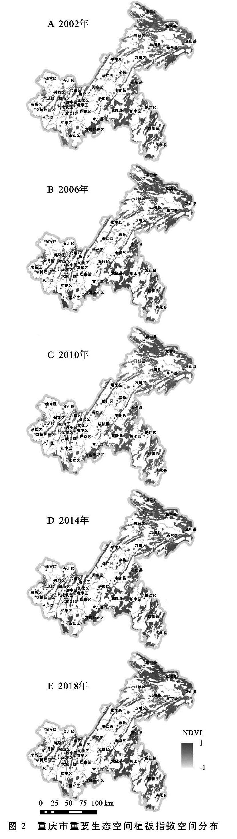
重庆市重要生态空间2002—2018年5期NDVI状况见图2。
总体来看,重庆市重要生态空间植被覆盖度在2002—2018年呈波动变化,但整体良好,2018年较2002年提高了5.04%。植被覆盖最好的区域为彭水县、酉阳县等渝东南地区,其2006年、2014年、2018年NDVI数值均为全市最高。其次是重要生态空间分布最为密集的渝东北,可从图中看出该区域植被覆盖整体较好。重庆市城区的重要生态空间主要集中在“四山”(中梁山、缙云山、铜锣山、明月山)的山体范围内和城市组团间的非建设用地隔离带,呈明显条带形态,由北向南倒指状贯穿主城区,城区主要的森林、绿地资源基本上均分布于此,植被覆盖度同样较高。NDVI数值低值区主要分布在长寿区、长江和嘉陵江干支流两侧(主要位于江津区、合川区与巫山县)。
从各年份的空间格局变化来看,2002—2006年,重庆城区和江津区重要生态空间NDVI略微上升,城口县部分区域NDVI大幅降低,其余区域变化较小。2006—2010年,重庆城区及城市扩展区NDVI数值出现明显剧烈下降,渝东北地区NDVI出现上升趋势,渝东南地区未发生明显变化。2010—2014年,重庆城区及城市扩展区主要以“四山”山体范围内NDVI呈明显正向变化,尤其北碚区的缙云山山脉NDVI明显提高,渝东南地区中彭水县出现NDVI退化趋势,渝东北地区则以城口、巫溪的重要生态空间为中心的向外扩散性降低变化。2014—2018年,重庆城区生态空间内的NDVI变化不明显,江津区、綦江区及万盛经开区出现了较为明显的降低,渝东南地区的生态空间内的NDVI几乎没有发生变化,渝东北地区则出现了以城口、巫溪等地的生态空间为中心向四周辐射的NDVI正向变化。
3.1.2 建筑指数
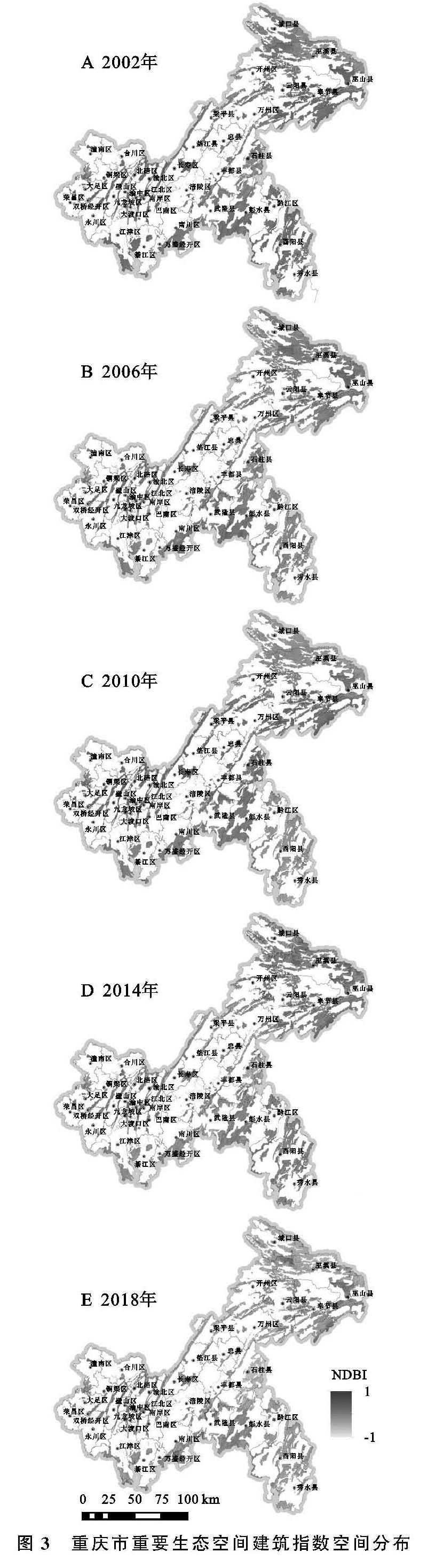
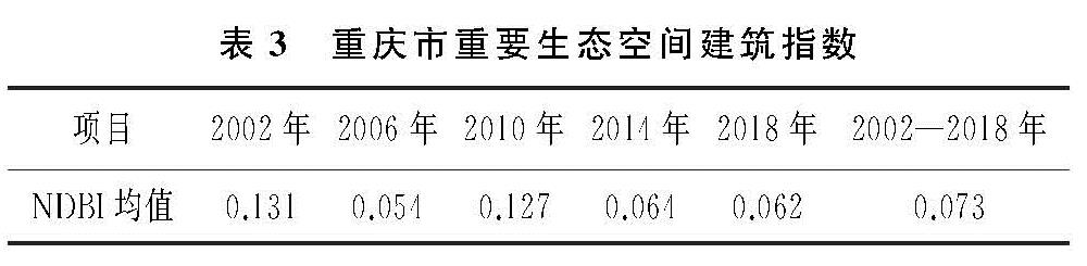
重庆市重要生态空间2002—2018年5期建筑指数空间分布和均值统计见图3和表3。
可以看出,重庆市重要生态空间NDBI均值呈现“降—升—降”的变化趋势,多年均值为0.073,说明总体而言研究区受人类影响的程度偏低。具体来看,城口县、巫溪县、丰都县和武隆区常年较低,巫山县中部、奉节县、云阳县、开州区和长寿区常年处于高值区,说明该区域建筑密度较大,人类活动频繁。剩余区域NDBI则处于中值区,该部分区域受到一定程度的人类活动影响,但影响程度不高。
从各年份的空间格局变化来看,2002—2006年,长寿区的低值区转化为中值区,渝东南地区的彭水县、黔江区、酉阳县和秀山县由中值区转化为低值区,重要生态空间全域NDBI均值极大降低。2006—2010年,长江干流两侧区县内的NDBI数值上升,全域均值又出现大幅回升。2010—2014年,渝东北区域NDBI数值出现上升,但重要生态空间其他区域NDBI有一定程度的降低,整体均值再次下降。2014—2018年城口县、巫溪县和石柱县NDBI数值明显降低,重要生态空间全域均值继续下降至0.062。
3.1.3 斑块破碎度
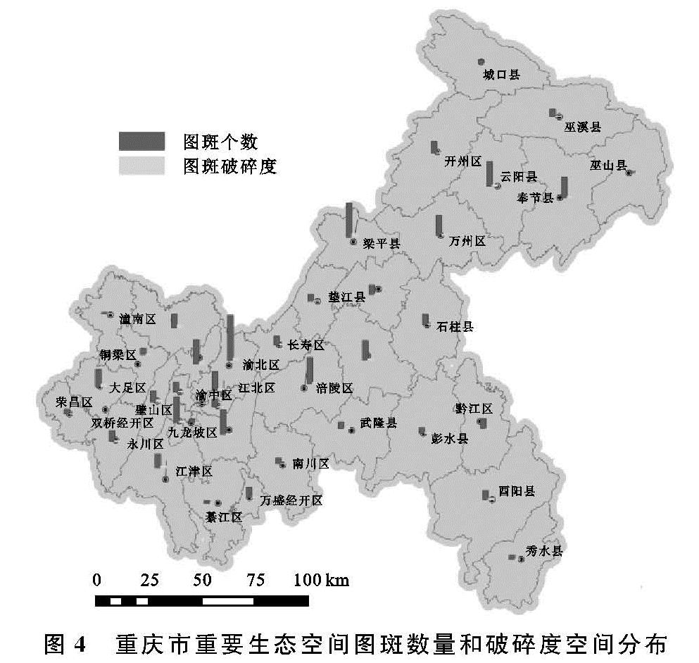
重要生态空间图斑数量、图斑的平均面积及图斑破碎度在重庆市各区县的分布呈现出较大的差异性(图4)。具体来看,重要生态空间图斑个数由1~118个不等,其中重要生态空间图斑个数最多的是渝北区118个,最少的是渝中区,仅1个,多数县区的图斑个数为30~70个。从各区县重要生态空间图斑的总面积来看,总面积最大的是巫溪县2 100.48 km2,总面积最小的是渝中区0.25 km2。从图斑的平均面积来看,重要生态空间平均图斑面积最大的是巫山县,平均图斑面积为516.44 km2,平均图斑面积最小的是渝中区0.25 km2。通过对全市各图斑的破碎度进行计算统计,全市各区县的图斑破碎度主要集中分布在0~4,其中重要生态空间图斑破碎度最大的是梁平区,图斑破碎度为9.44,破碎度最小的是渝中区,仅为0.02。
3.2 重要生态空间生境质量评价结果
重庆市重要生态空间生境质量评价结果见表4。2002—2018年整体变化中,全市重要生态空间生态环境质量整体上呈波动上升趋势,由85.10分上升至86.24分,而北碚区、奉节县、江北区、南川区、沙坪坝区、万盛经开区、巫山县、武隆区和渝中区9个区县(开发区)2018年生境质量分数较2002年出现降低,剩余区县均有一定程度的提高。具体来看,2002年、2006年、2010年、2014年、2018年5个时期中,评分最低的均位于梁平区,多年平均值仅有64.66分,各年份评分最高的分别位于秀山县、綦江区、城口县、綦江区和城口县,其得分保持在97分以上。
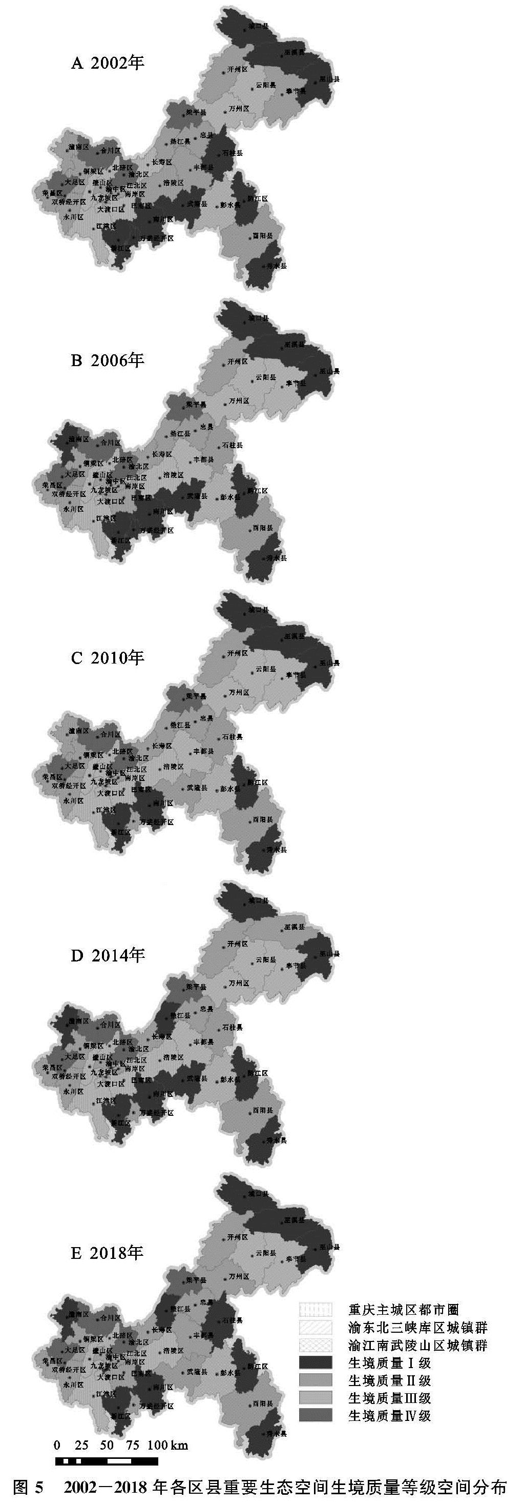
通过对重庆市各个区县重要生态空间生境质量等级研究结果(表4,图5)来看,2002—2018年生境质量各个等级之间的波动较小,各区县生态空间大多数处于生境质量Ⅱ级和Ⅲ级。
2002年生境质量Ⅰ级的区县有10个,分别是万盛经开区、黔江区、綦江区、城口县、武隆区、巫山县、巫溪县、石柱县、秀山县、南川区,生境质量Ⅱ,Ⅲ级的区县分别有14个和11个,生境质量Ⅳ级的区县有4个,分别是梁平区、大足区、合川区、渝北区。2006年生境质量Ⅰ级的区县有10个,较2002年增加了潼南区,而石柱县下降至Ⅱ级,生境质量Ⅱ级的区县有13个,较2002年减少1个,生境质量Ⅲ级的区县12个,较2002年增加1个,生境质量Ⅳ级的4个区县没有变化。
图5 2002-2018年各区县重要生态空间生境质量等级空间分布
2010年生境质量Ⅰ级的区县有7个,分别是黔江区、綦江区、城口县、巫山县、巫溪县、秀山县、南川区; 生境质量Ⅱ,Ⅲ级的区县分别有14个和13个; 生境质量Ⅳ级的区县的5个,较2006年增加了渝中区。2014年生境质量Ⅰ级的区县有9个,分别是黔江区、綦江区、潼南区、城口县、垫江县、武隆区、巫山县、秀山县、南川区; 生境质量Ⅱ级的区县有13个; 生境质量Ⅲ级的区县12个; 生境质量Ⅳ级的区县有5个,分别是梁平区、大足区、合川区、渝北区、渝中区。2018年生境质量Ⅰ级的区县有11个,分别是大渡口区、黔江区、綦江区、城口县、垫江县、巫山县、巫溪县、石柱县、秀山县、南川区; 生境质量Ⅱ级的区县有14个; 生境质量Ⅲ级的区县10个; 生境质量Ⅳ级的区县有4个,依旧是是梁平区、大足区、合川区、渝北区。