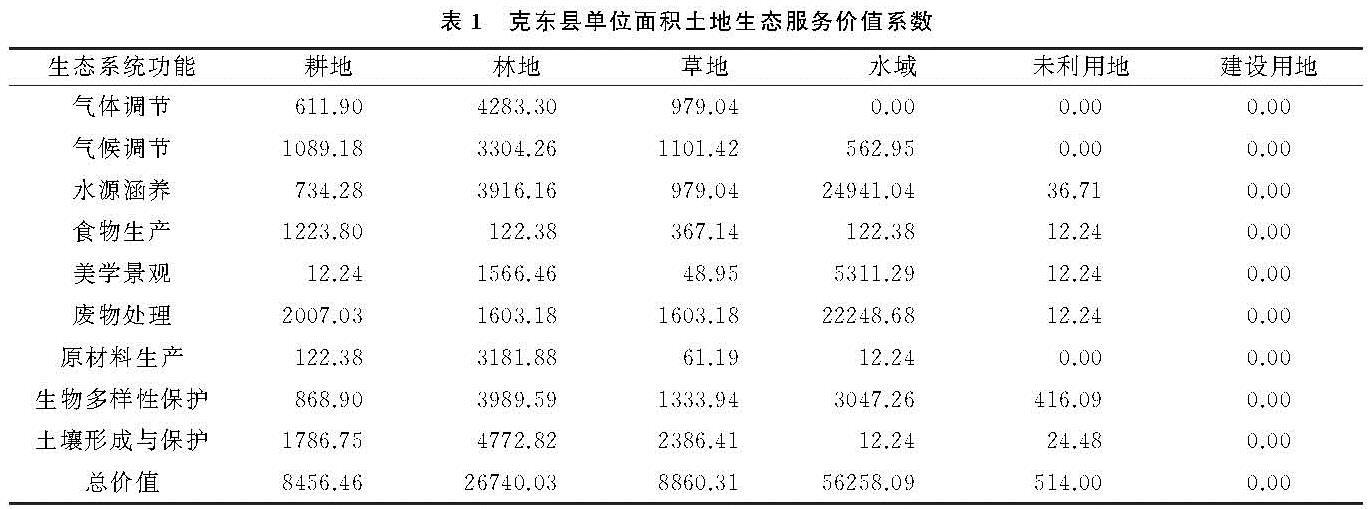
3.1.1 土地生态服务价值评价
根据表1在ArcGIS 10.2中对克东县土地生态系统服务价值进行核算,并将结果利用自然断点法分为低值区、一般值区、中值区、高值区和极值区5类(图1)。根据评价结果显示(表4),克东县生态系统服务价值总体较低,大部分处于一般值及以下水平。其中一般值区最多,面积为822.04 km2,占县域总面积的50.7%。极值区分布最少,面积仅为5.46 km2,占县域总面积的0.34%。空间分布上,低值区和一般值区相间分布,中值区零星分布,高值区分布于县域内的玉岗镇、蒲峪路镇、润津乡和昌盛乡,极值区主要在宝泉镇,蒲峪路镇和玉岗镇有零星分布。
结合克东县景观分布,低值区和一般值分布与克东县建制镇、农村居民、建设用地以及小面积耕地等分布相一致; 零星分布的中值区与县域内大面积耕地、林地、草地分布有关; 分布于四乡镇的高值区是以光荣水库和润津河为主的水域和沿河流分布的林草地等; 极值区是县域内的玉岗水库和乌裕尔河。水域和大面积林草地作为县域内主要生态用地,是保障县域内水源涵养、气候调节以及污染物处理等生态功能的主要区域,生态环境质量较高,因此是县域内生态服务价值的高值区。建制镇、居民点和其他建设用地作为人类活动最频繁区域,生态服务功能减弱的同时,在建设用地集中区域,环境污染等生态问题开始出现,因此其不但无法提供生态服务功能,还会对县域内生态产生负向作用,因此被划定为低值区。
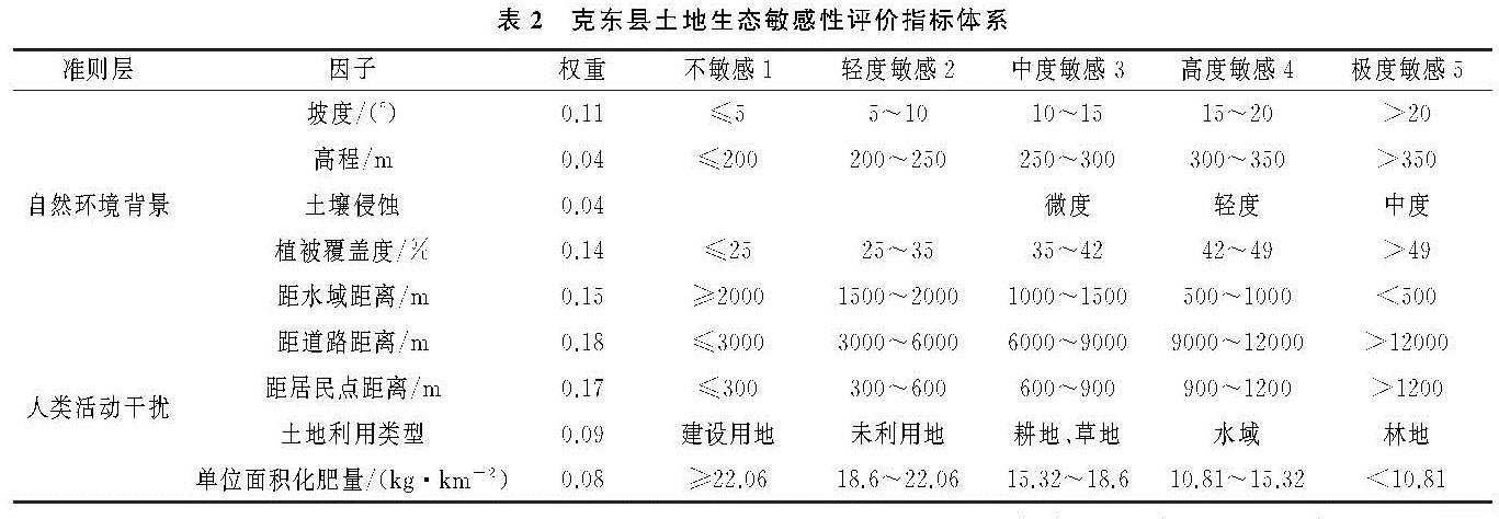
3.1.2 土地生态敏感性评价
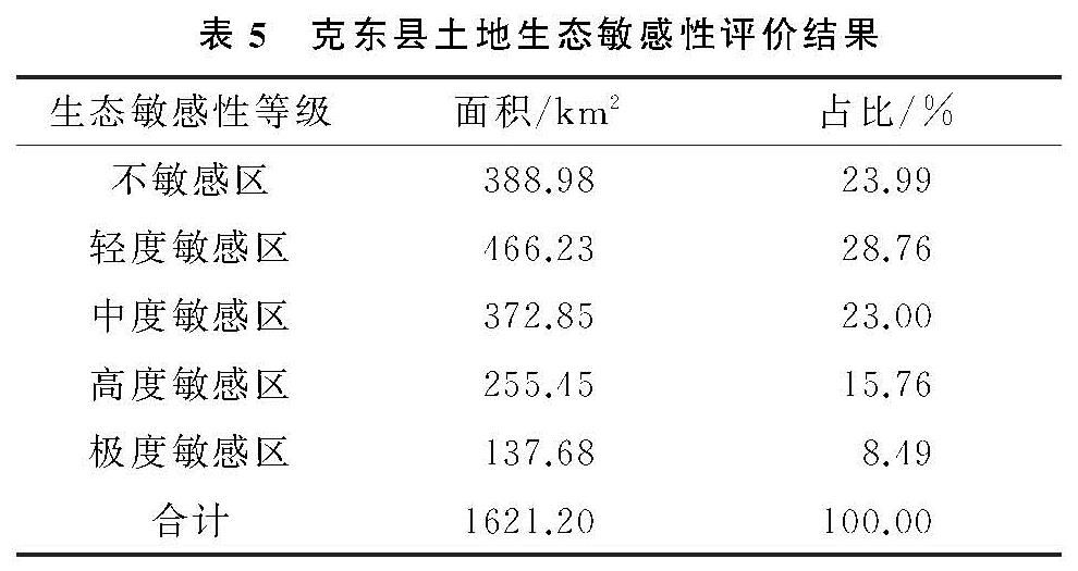
根据表2克东县土地生态敏感性评价指标体系表,在ArcGIS 10.2中对克东县土地生态敏感性进行评价计算,并将评价结果利用自然断点法分为不敏感区、轻度敏感区、中度敏感区、高度敏感区和极度敏感区5等(图1)。土地生态敏感性评价结果显示(表5),克东县土地生态敏感性整体较低,大部分处于轻度敏感及以下水平。其中轻度敏感区域面积最多,面积为466.23 km2,占县域总面积的28.76%; 极度敏感区域面积最少,面积为137.68 km2,占县域总面积的8.49%。空间分布方面,不敏感和轻度敏感区域分布于县域中部的克东镇和蒲峪路等乡镇,中度敏感区、高度敏感区和极度敏感区零星分布在玉岗镇、润津乡和宝泉镇。
克东县不敏感和轻度敏感区域主要分布于县域内的农村居民点、建制镇以及公路线周边。这部分区域内人类生产生活等活动频繁,生态系统较为简单,生态敏感性较弱。不敏感和轻度敏感区作为适宜开发建设区,可因地制宜布局县域农业和工业等相关产业,促进县域经济发展。但开发建设过程中要重视生态环境问题,农业发展要合理控制农药化肥等施用量,增加有机肥施用量,坚持农业清洁生产; 工业要坚持发展生态型产业,严禁以破坏生态环境为代价发展经济。中度敏感、高度敏感区和极度敏感区主要由县域内乌裕尔河、玉岗水库等水域、林草生态用地构成,这部分区域作为县域内生态质量最好的区域,不仅保证着区域生物多样性稳定,而且为土壤保持和水源涵养等提供支持,促进了县域内土地生态系统和农业生态系统的可持续发展,必须给予严格保护。水源地要重视水资源污染等问题,保护水源地水源涵养等功能; 林草地区域要积极实施林草生态工程,不断提高区域林草面积,为区域生物多样性建设等提供保护。
3.2 克东县土地生态安全格局构建
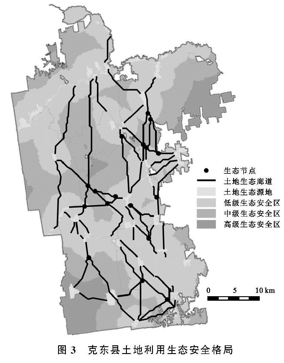
生态安全格局是由生态源地、生态安全区、生态廊道和生态节点等要素构成的复杂的生态安全网络。本文基于识别生态源地、确定生态安全区、构建生态廊道和识别生态节点的思路构建克东县土地生态安全格局。
本文通过生态评价识别土地生态源地总面积为56.7 km2,占县域面积3.5%。空间分布特征方面,土地生态源地集中分布于县域北部的乌裕尔河和中部润津河周边地区,少量分布于县域南部地区; 土地生态源地土地利用类型主要包括水域、草地、林地,此外县域内的少量耕地,由于生态敏感性较高,水土流失严重,不适宜继续耕作,需将土地利用类型改变为林地、草地,补充为生态源地; 土地生态源地乡镇分布方面,宝泉镇、玉岗镇生态源地分布面积最广,这与乌裕尔河、玉岗水库等生态源地空间分布相关。
本文生态源地管控主要包括源地均匀化配置和源地分类管控。由于通过评价识别的土地生态源地存在分布不均匀问题,因此需要通过均匀化配置改善县域南部生态源地面积较少问题。结合县域生态用地分布现状,选择南部地区生态用地分布相对集中区域作为基础,然后通过退耕还林还草等工程将其周围地块转为新增生态用地,最终实现生态用地集中连片。通过建设及识别,新增生态源地2块,新增面积为7.96 km2,生态源地总面积为64.66 km2,占县域面积3.99%(图2),通过增加生态源地的方式,不仅解决了县域内生态源地分布不均匀问题,而且间接增加了县域生态网络密度,提高了县域生态安全格局的稳定性。
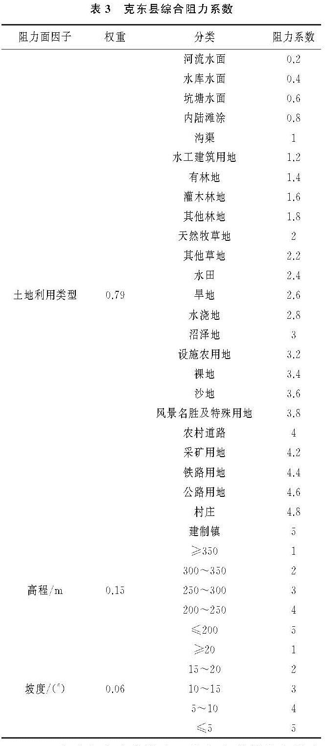
生态源地分类管控。本文生态源地主要由水域、林地和草地等构成,其次是耕地。水域生态源地作为县域内重要水源补给点,为县域农业灌溉和畜牧养殖发展提供有力支持。水域源地生态管控要减轻种植业和畜牧养殖业等领域污染,保护水域生态质量稳定。种植业要减少农药化肥使用量,增加有机肥的使用,降低化学品对水域生态环境质量威胁。畜牧养殖业要控制好养殖领域污染,严格把控新建、改造和扩建的畜禽养殖场区粪污处理设施,减少粪污等对水域环境质量威胁。林地和草地源地除部分沿乌裕尔河和润津河集中分布外,其他均呈现分散分布状态,源地面积也相对较小。针对沿河流集中分布的林地和草地生态源地,可以依托水域和林草地环境优势,实施人工造林等工程,增加生态源地面积,并在水域和林草生态源地集中分布区域建立保护区,进一步强化生态源地在安全格局中的基础作用。分散分布的林草生态源地基本处于耕地交汇地区,这类源地要实施严格的生态保护,同时可以根据源地周围环境,通过实施退耕还林还草等生态恢复工程改变耕地用途,增加生态源地面积,降低区域水土流失风险,增强区域生态系统稳定性。
生态安全区建立。根据最小累计阻力值和栅格面积阻力突变点确定克东县3种不同水平的生态安全区。其中低级生态安全区面积为885.5 km2,占县域面积54.62%。低级生态安全区围绕生态源地分布,生物种类丰富,且物种运动和能量交流转换遭受阻力最小,适宜实施最为严格生态保护; 中级生态安全区面积为599.22 km2,占县域面积36.96%。中级生态安全区作为安全区过渡带,仍以生态环境保护为主,适宜作为限制建设区。高级生态安全区面积为136.48 km2,占县域面积8.42%。高级生态安全区位于生态安全区最外层,生物运动受到阻力最大,且人类活动最为频繁,适宜作为建设区,进行合理开发。
生态安全区管控以合理控制开发强度为主。不同级别的生态安全区为县域区分开发建设强度提供科学指导。由图3可知,低级生态安全区围绕生态源地分布,是生态源地内生物和能量转换的最佳休憩区。本区域要实施最严格生态保护,首先禁止毁林开荒、工矿开采等严重破坏植被质量的人类活动; 其次需要调整产业架构,坚决发展生态农业; 最后要控制生产生活中的污染排放问题,居民点要远离水域、林地等生态用地,居民点布局尽量实现集中安置,确保区域内水资源质量和使用安全。中级生态安全区作为过渡地带,是县域内的限制开发区,在发开建设中具有一定的灵活性。本区域在坚持生态保护优先基础上,适宜合理布局对区域生态环境干扰较小的旅游和交通等设施。高级生态安全区作为距离生态源地最远的区域,人类活动最频繁,经济和建筑密度最高,因此适宜作为开发建设区,布局建设县域内的工业园区以及重大产业项目基地,同时规划布局相关基础设施,鼓励和吸引人口集聚居住,将其建设成为推动县域经济增长的集中区域。
基于评价识别的土地生态源地和综合阻力面生成60条生态廊道,总长度为372.28 km,土地生态廊道在全域范围内经过的土地利用类型以林地、草地和耕地为主。根据生态廊道交汇情况识别生态节点18个。生态廊道和生态节点在润津乡和玉岗镇等县域中部和北部地区分布较为集中,乾丰镇等南部乡镇分布相对较少。润津乡和玉岗镇境内分布数目较多的生态源地,且两个乡镇内拥有润津河、玉岗水库等大面积的土地生态源地,因此生态廊道和生态节点在润津乡和玉岗镇集中分布。
生态廊道管控以调整生态廊道长度、增加生态廊道数量和建设生态廊道缓冲区为主。本文生态廊道土地利用类型以耕地为主,其次是林地、草地和水域,未利用地和建设用地最少。由图3可知,乌裕尔河和润津河、润津河和县域南部源地间存在多条长距离生态廊道,为保证生态廊道生态作用,需要在生态廊道和林地、草地、水域等土地利用类型交汇处将长距离廊道进行分段。生态廊道距离调整不仅改善了部分地区生态源地和生态廊道较少的状况,还进一步提升了县域生态安全格局稳定性。根据新增加的生态源地,在县域东南部补充3条生态廊道,总长度为19.01 km,补充后生态廊道总长度为391.29 km。增加生态廊道数量不仅为新增生态源地内物种运动和能量交流转换提供了途径,还进一步提升了县域西南部生态安全格局稳定性。生态廊道缓冲区建设是根据县域内生物物种类型为生态廊道建立一定宽度缓冲区,缓冲区范围内不允许开展工程建设活动。生态廊道缓冲区建设降低了外部环境对生态廊道干扰,保障了生物运动安全和能量交流转换效率。
生态节点管控以保护节点处生态环境和调整生态节点布局为主。本文生态节点土地利用类型与生态廊道土地利用类型相似,生态节点管控措施也是以保护林地、草地和水域用地生态环境,提高节点处生态环境稳定性为主。此外,针对位于建设用地上的生态节点,要采取相应的工程措施将节点进行调整,例如对建设用地实施生态恢复等工程措施,或者在控制如居民点等建设用地范围基础上,规划新生态节点,减少人类活动对生态节点破坏,提高节点处生态功能。
综合17块土地生态源地、3种不同等级生态安全区、63条生态廊道和18个生态节点构建克东县土地生态安全格局(图3)。