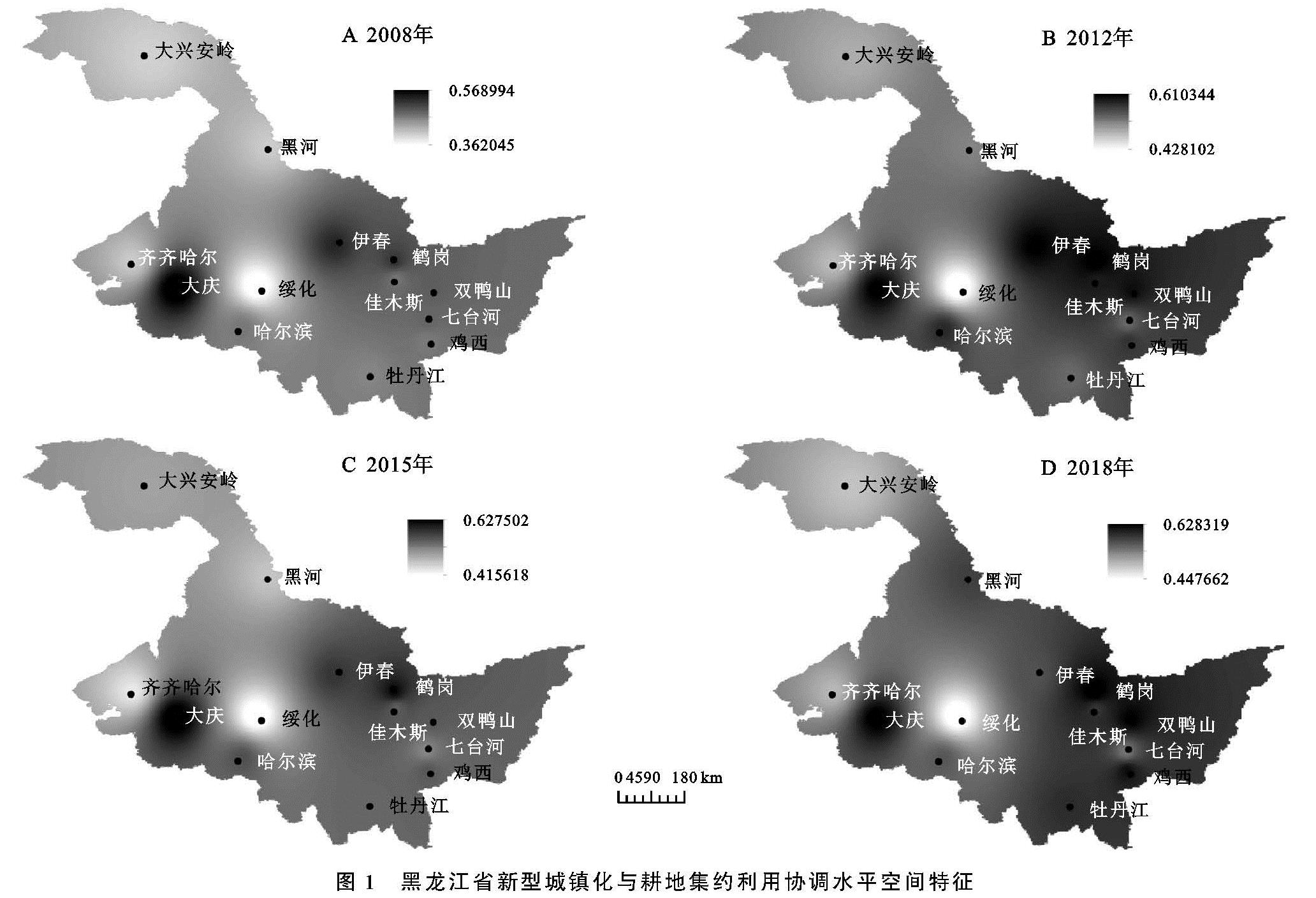
3.1 时间测度分析
2008—2018年黑龙江新型城镇化与耕地集约利用水平协调度处于0.35~0.65,协调程度处于轻度失调与初级协调之间。2009—2012年,多数城市呈稳步增长态势,2012年之后各城市协调度波动缓慢增长,整体波幅较小。2008—2014年大庆协调度水平均保持首位,2015年首次被鹤岗超越; 佳木斯、大兴安岭在2012年后新型城镇化与耕地集约利用水平呈缓慢平稳增长,之后基本处于勉强协调水平。齐齐哈尔除2015年外基本处于濒临失调状态; 七台河11 a间协调度在0.48~0.54,协调度水平从濒临失调上升为勉强协调; 绥化在黑龙江省内,协调度处于末尾,且与其他城市协调水平相差较大; 2018年除绥化、大兴安岭地区、齐齐哈尔,其他地市协调水平均已达到协调。大庆与鹤岗协调度水平虽均处前列,但因素影响不尽相同。
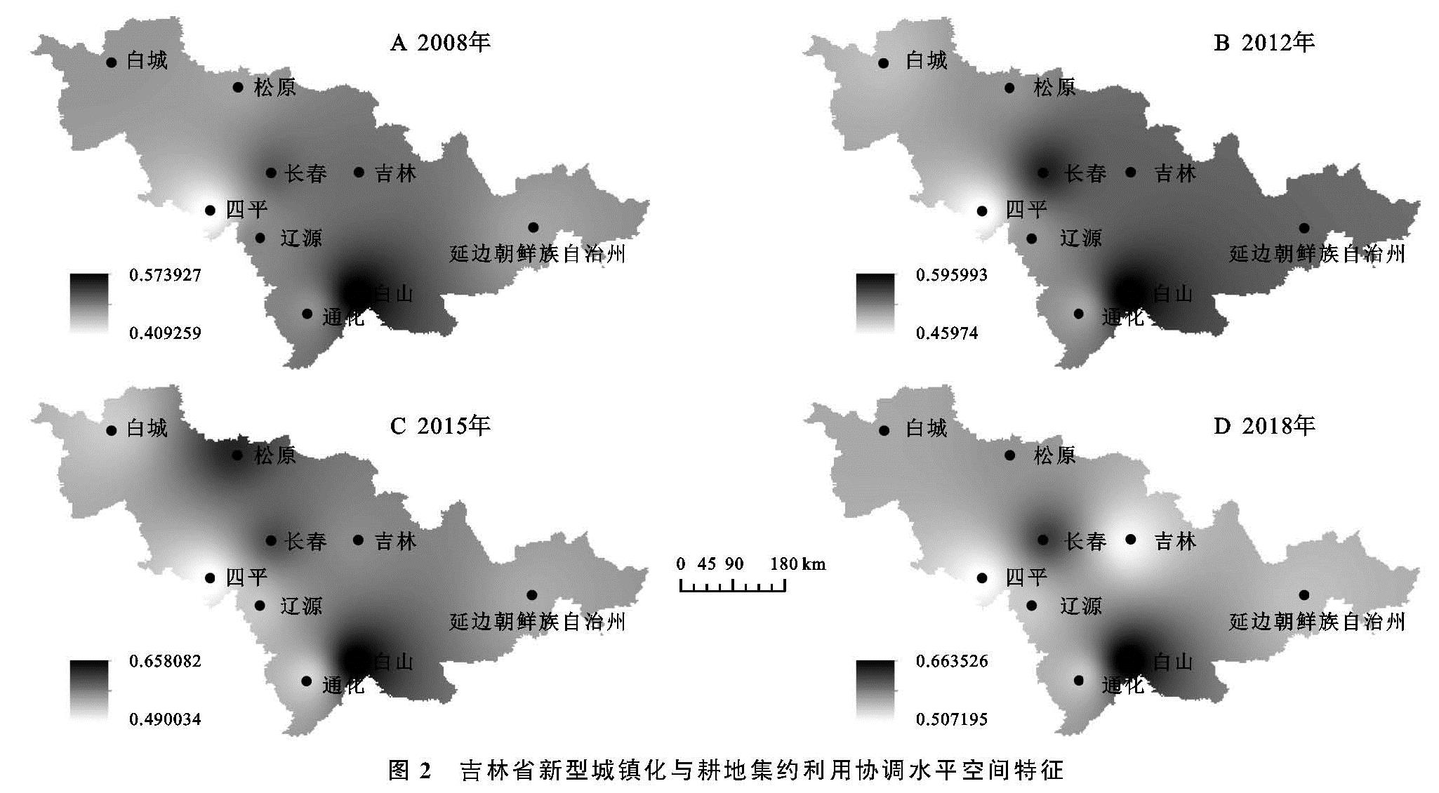
2008—2018年吉林新型城镇化与耕地集约利用水平协调度处于0.4~0.7,协调程度处于濒临失调到初级协调之间,整体协调度高于黑龙江省,且2018年所有城市均已达到协调水平。长春、延边朝鲜自治州、通化、辽源、白城、四平11 a间城镇化与耕地集约利用呈稳定增长,其中,长春协调度增幅大于其他城市,在2018年达到初级协调; 延边朝鲜自治州、通化、辽源、白城协调度环比增幅均在0.03之内。白山、松原协调度先增后减,且波幅较大,吉林协调水平11 a间均处于勉强协调,在2018年降幅明显,与省内协调度最低城市(四平)均为0.51。
2008—2018年辽宁新型城镇化与耕地集约利用水平协调度处于0.4~0.7,协调程度处于濒临失调到初级协调之间,整体协调水平与吉林持平,高于黑龙江省,2018年均处于协调水平。除盘锦、抚顺、葫芦岛、营口、锦州外,其他城市协调度在2014—2015年达到峰值后下降到5 a内最低值,之后在2017—2018年各城市呈不同的增长幅度,其中铁岭、朝阳增幅最大分别为0.11,0.07。11 a间锦州、葫芦岛呈小幅波动增加,均处勉强协调,其中葫芦岛协调度均处于0.5~0.55,增幅最小。2008—2018年营口、盘锦、抚顺协调度呈先增长后降低。
整体来看,吉林、辽宁地势相对开阔,便于农业机械作业,且经济作物指数、地均产值均高于黑龙江,城镇化整体发展优于黑龙江,因此,吉、辽两省整体协调水平高于黑龙江。从时序特征来看,三省多数城市2014年后协调度波幅大于2014年前,考虑到受政策及对社会各部门的改革举措影响,城镇化及耕地集约利用协调水平呈暂时性无序波动,但整体仍呈上升趋势。大庆作为早期工业发达城市,城镇化发展进程优于其他城市,拥有较强的城镇建设基础,其新型城镇化水平始终高于哈尔滨,鹤岗新型城镇化水平虽为省内中等,但其灌溉条件与农业机械化水平均优于其他城市,而绥化经济发展后劲不足,城镇化建设始终处于低水平状态,协调发展水平较低。长春、白山人口城镇化率及基础设施水平均显著高于其他城市,新型城镇化综合得分较高,因此两市协调发展水平位居省内前列。辽宁多数城市2015—2017年协调度呈下降态势,其源于产业结构转型、地方债务置换、数据统计等多种原因导致的社会固定资产投资的大幅下降。
3.2 空间特征分析
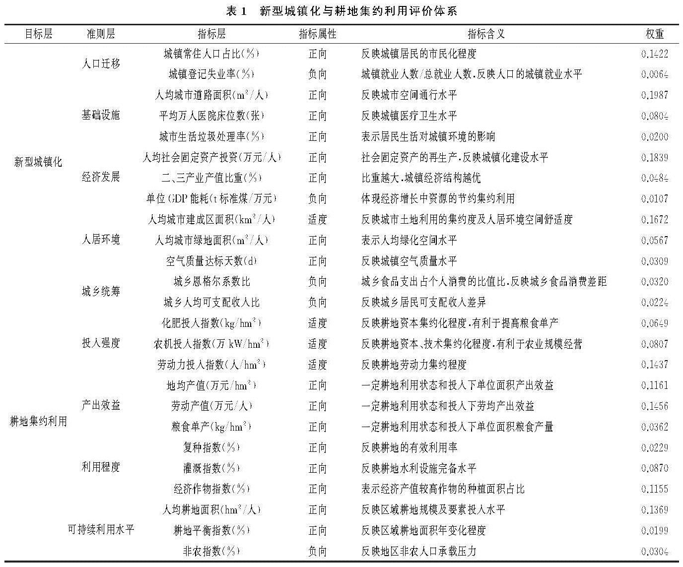
利用ArcGIS反距离插值法对黑吉辽3省2008年、2012年、2015年、2018年新型城镇化与耕地集约利用水平耦合协调度进行空间分析。黑龙江省新型城镇化与耕地集约利用效益协调度水平空间差异明显,4年间整体协调度水平呈上升态势,大庆、鹤岗为协调度高值城市,绥化始终为协调度低值区,协调度整体态势为东部协调度高水平地区连片面状布局,西部低水平地区切割分布。2008年,黑龙江东部以伊春为核心向外扩展逐渐降低,高值城市大庆位于齐齐哈尔及绥化两大低协调度城市之间,与2008年相比,2012年黑龙江省东南部协调度水平明显提升,东部区域协调度差异逐渐降低,东高西低态势更为明显,从2015年及2018年协调度水平空间特征可以看出,双鸭山、佳木斯、伊春由中等协调水平逐步形成高值面状区,黑河协调度有较明显提升,绥化11 a间协调度增速缓慢,大庆、哈尔滨、伊春等周边高值城市对其无明显带动作用(图1)。
吉林省新型城镇化与耕地集约利用水平协调度区域差异明显,4年间空间特征变化波幅较大,由东高西低逐渐演变为双核心格局,长春、白山始终为协调度高值城市,白城、四平、辽源、通化等西部城市均为低水平协调城市。2008年协调水平空间格局为以白山为核心,向外扩散逐渐降低。2012年长春、延边朝鲜族自治州增幅明显,形成东高西低的空间分布形态,与2012年相比,2015年协调度值增长区域由东部转为北部,松原协调度有明显提升,中部耦合协调水平明显高于东西地区,2018年松原协调度优势弱化,整体呈现由白山、长春引导的双核心高值区,向外扩散协调水平逐渐降低的空间态势(图2)。
辽宁省城镇化与耕地集约利用空间特征4年间无显著变动,整体空间结构相似,呈东高西低分布。大连始终为协调度水平最高城市,朝阳、锦州、阜新、葫芦岛、铁岭始终为协调度低值区。2008年辽宁中部为优势协调度连片区,低值城市为西部4市、北部铁岭及东部丹东,与2008年相比,2012—2015年丹东协调水平有所提升,接近初级协调,辽宁东部协调度空间差异性降低,到2018年盘锦、鞍山、本溪、抚顺协调度优势弱化,形成以沈阳、营口、大连为核心的南北走向带状高值区。综合来看,协调度变化活跃区集中在辽宁东部,西部区域协调度空间位序无明显变化,东西部城镇化与耕地集约利用协同发展水平差异始终存在(图3)。
图1 黑龙江省新型城镇化与耕地集约利用协调水平空间特征
图2 吉林省新型城镇化与耕地集约利用协调水平空间特征
图3 辽宁省新型城镇化与耕地集约利用协调水平空间特征