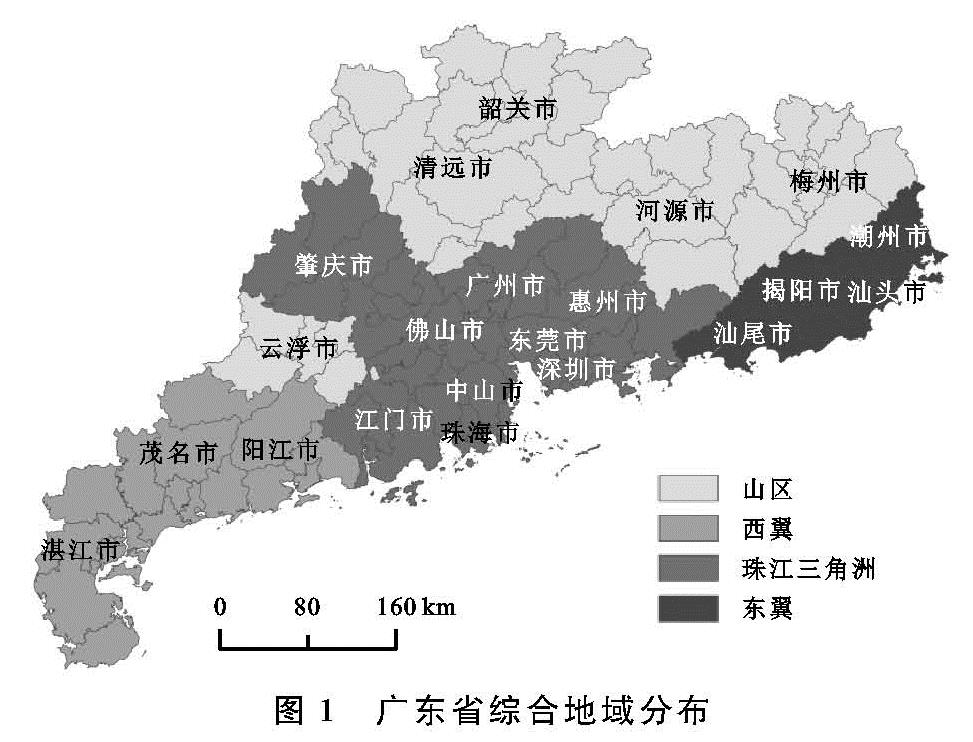
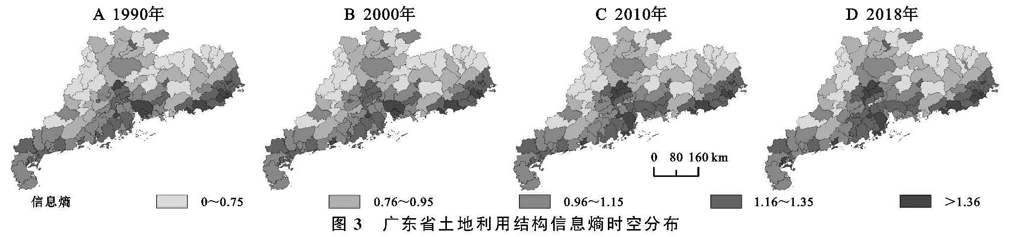
3.1 广东省土地利用结构信息熵时空分布
1990年、2000年、2010年和2018年广东省土地利用结构信息熵均值分别为1.056,1.063,1.063,1.077,总体呈现增加—平稳—增加的趋势(图2)。分区域分析发现东翼、西翼、珠江三角洲和山区土地利用结构信息熵均值分别为1.280,1.107,1.056,0.817,即东翼>西翼>珠江三角洲>山区。1990年、2000年、2010年和2018年,东翼土地利用结构信息熵均值分别为1.273,1.277,1.280,1.290,总体呈现持续增加的趋势; 西翼土地利用结构信息熵均值分别为1.097,1.106,1.104,1.123,总体呈现增加—平稳—增加的趋势; 珠江三角洲土地利用结构信息熵均值分别为1.050,1.061,1.058,1.054,总体呈现增加—持续降低的趋势; 山区土地利用结构信息熵均值分别为0.806,0.808,0.810,0.817,总体呈现持续增加的趋势。1990—2000年,珠江三角洲土地利用结构信息熵增加最大(0.011),西翼次之(0.009),东翼第三(0.004),山区最小(0.002),说明主要是由珠江三角洲和西翼土地结构信息熵的增加导致广东省平均信息熵的增加。2000—2010年珠江三角洲和西翼土地利用结构信息熵分别降低0.003,0.002,而东翼和山区分别增加0.003,0.002,因此保持了广东省土地利用结构信息熵的平稳。2010—2018年珠江三角洲土地利用结构信息熵降低0.004,而西翼、东翼和山区分别增加0.019,0.010,0.007,从而导致广东省该时期土地利用结构信息熵增加。
图3进一步展示了县区行政区土地利用结构信息熵,可以发现广东省土地利用结构信息熵存在显著的空间差异。广东省南部沿海及中部地区土地利用结构信息熵较高(高于0.95),而北部和西部山区土地利用结构信息熵处于最低水平(低于0.95)。其中,东翼沿海大部分县区土地利用结果信息熵长期保持1.16以上,个别县区长期保持在1.36以上; 珠江三角洲各县区土地利用结构信息熵大部分维持在1.16以上,但是变化趋势不同,深圳市和东莞市附近土地利用结构信息熵随时间有高值区向中值区发展,广州市中心区域土地利用结构信息熵低值区区域随时间有所增加; 西翼土地利用结构信息熵处于中高值区,到2018年麻章区和江城区信息熵增加到1.36以上。
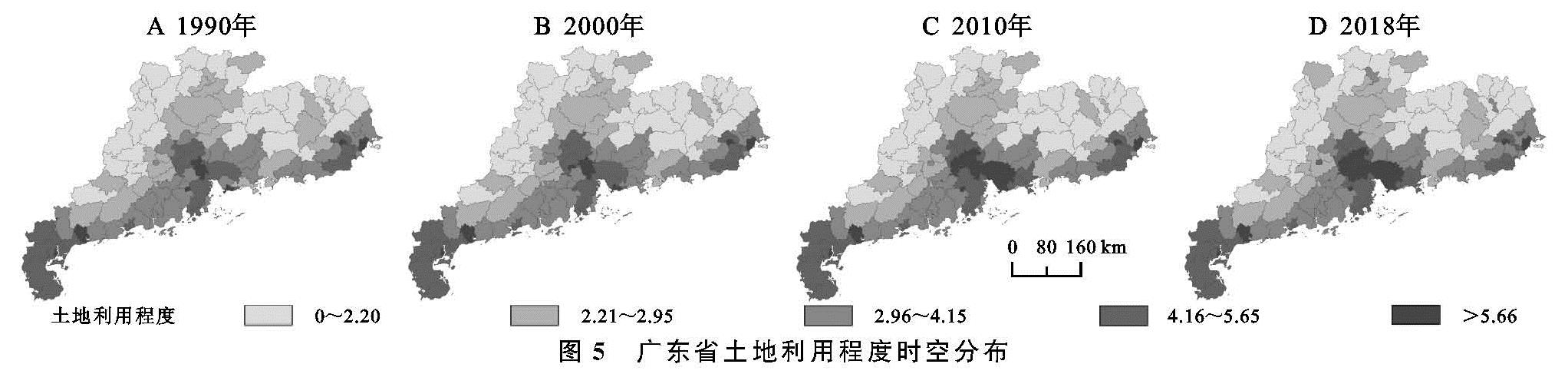
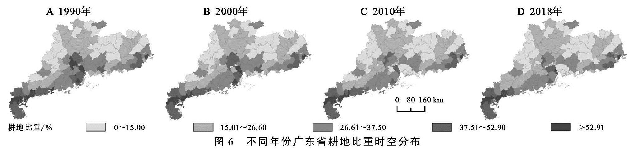
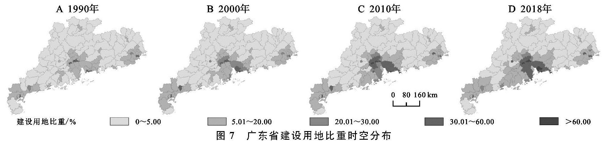
3.2 广东省土地利用程度、耕地比重和建设用地比重时空分布
如图4所示,1990年、2000年、2010年和2018年广东省土地利用程度年均值分别为3.53,3.62,3.78,3.88,表现为持续增加的趋势; 其西翼均值分别为4.57,4.62,4.63,4.60,珠江三角洲均值分别为4.03,4.21,4.58,4.78,东翼均值分别为3.92,3.95,4.03,3.99,山区均值分别为2.16,2.15,2.19,2.27。结果表明区域总体呈现为西翼>珠江三角洲>东翼>山区,土地利用程度在东西两翼呈现增加—增加—降低的趋势,在珠江三角洲呈现持续增加的趋势,山区呈现轻微降低—增加—快速增加的趋势。
1990年、2000年、2010年和2018年广东省耕地比重均值分别为31.57%,30.00%,27.86%,27.23%,表现为持续降低的趋势; 其西翼均值分别为44.40%,42.17%,40.86%,41.19%,珠江三角洲均值分别为31.55%,27.04%,21.89%,20.93%,东翼均值分别为32.56%,32.94%,31.49%,30.06%,山区均值分别为17.74%,17.77%,17.18%,16.74%。结果表明区域耕地比重总体呈现为西翼>东翼>珠江三角洲>山区,耕地比重在西翼呈现降低—降低—增加的趋势,在东翼呈现增加—降低—降低的趋势,在珠江三角洲呈现降低—快速降低—降低的趋势,山区呈现轻微增加—持续降低的趋势。
对建设用地比重分析发现,1990年、2000年、2010年和2018年广东省建设用地比重均值分别为9.60%,11.39%,14.13%,15.10%,表现为持续增加的趋势; 其西翼均值分别为11.16%,13.40%,14.25%,13.50%,珠江三角洲均值分别为13.73%,18.61%,26.28%,29.18%,东翼均值分别为11.70%,11.78%,13.60%,14.09%,山区均值分别为1.80%,1.76%,2.33%,3.62%。结果表明区域建设用地比重总体呈现为珠江三角洲>西翼>东翼>山区,建设用地比重在西翼呈现增加—增加—降低的趋势,在东翼呈现持续增加的趋势,在珠江三角洲呈现持续快速增加的趋势,山区呈现轻微降低—持续增加的趋势。
3.2.1 土地利用程度时空分布
进一步分析了广东省土地利用程度的时空分布(图5),可以发现广东省土地利用程度存在显著的空间差异。广东省南部沿海及中部地区土地利用程度较高(高于2.95),而北部和西部山区土地利用程度处于最低水平(低于2.95)。其中,东翼的个别县区长期保持在4.15以上; 珠江三角洲中心县区土地利用程度高值区增加迅速,到2018年大于5.66的县区明显增多; 西翼的化州市和电白县(不包括)以南土地利用程度长期处于4.15以上。
3.2.2 耕地比重时空分布
从图6可以看出,耕地比重和土地利用程度空间分布相似,以珠江三角洲中心区和东、西翼沿海县区耕地比重最高。随着时间的推移,耕地比重高值区显著减少,其中珠江三角洲中心城区耕地比重减少最为明显,低于15.00%的县区由1990年的一个增加到2018年的广州市中心区、深圳市和东莞市周边的12个区,高于52.90%的区域也由1990年的6个区减少到2018年的一个南沙区,而东西两翼耕地比重时空分布基本保持不变或轻微降低。到2018年只有东翼的澄海区、珠江三角洲的南沙区、西翼的个别县区耕地比重保持高于52.90%的状态。
3.2.3 建设用地比重时空分布
建设用地比重高值区同样也以珠江三角洲中心区和东西翼沿海县区建设用地比重最高(图7)。随着时间的推移,建设用地比重高值区显著增加,其中珠江三角洲中心城区建设用地比重增加最为明显,具体来说建设用地比重大于30.00%的县区由1990年的广州中心六区和深圳市中心三区,逐渐扩展到2018年20个县区,并且随着中心区建设用比重的升级,周边县区建设用地比重也在不断扩大和升级,而东西两翼建设用地比重大部分维持在低于20.00%的水平,只有少数县区持续高于30.00%。
3.3 广东省土地利用结构信息熵驱动因子分析
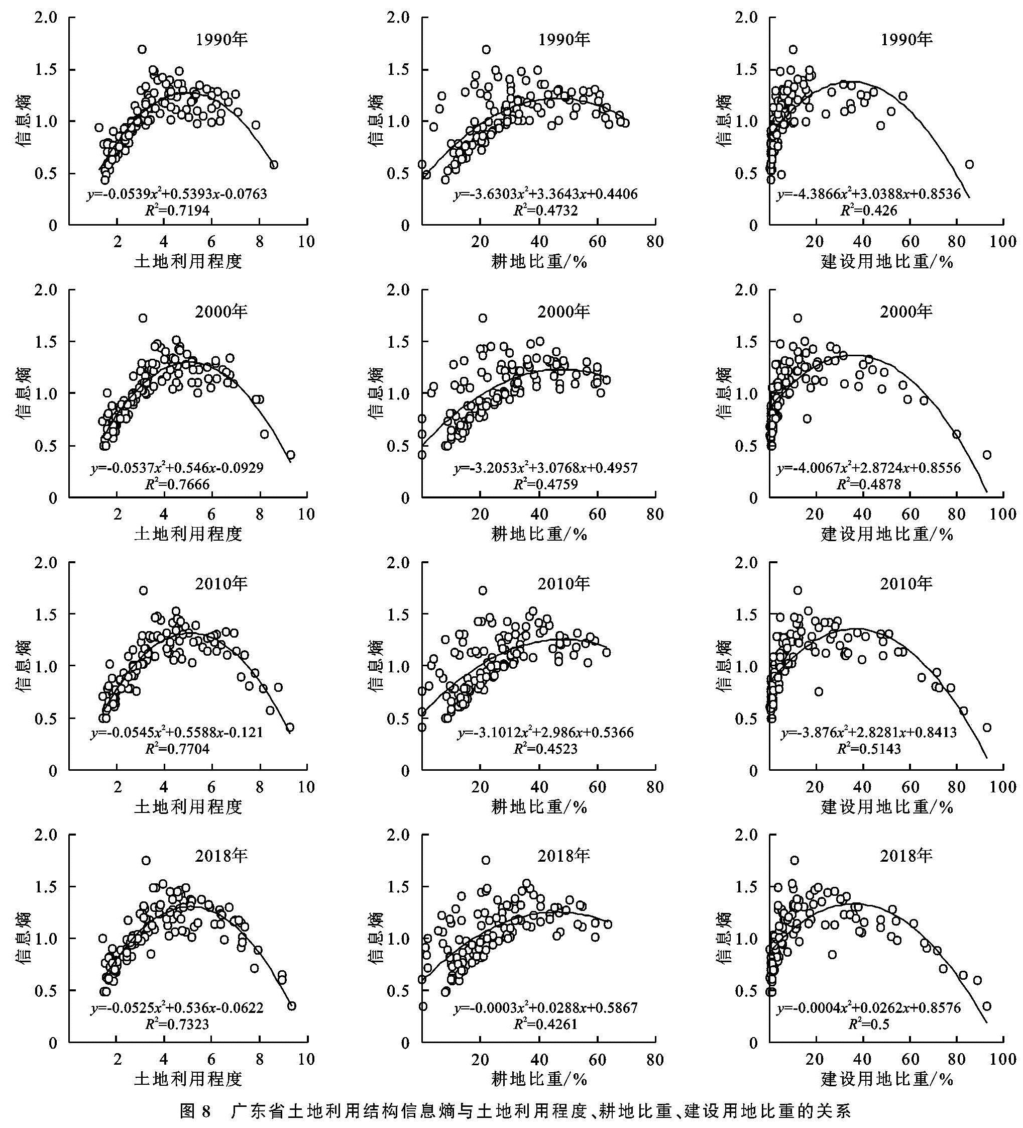
为了揭示广东省土地利用结构信息熵分别与土地利用程度、耕地比重和建设用地比重的空间关系,本研究根据土地利用结构信息熵分别与土地利用程度,耕地比重和建设用地比重的散点图做进一步分析(图8)。
图8 广东省土地利用结构信息熵与土地利用程度、耕地比重、建设用地比重的关系
从1990年、2000年、2010年和2018年4个时间点散点图可以看出土地利用程度、耕地比重和建设用地比重都与土地利用结构信息熵存在倒U型关系。从平方线性拟合函数可以看出,R2分别在0.71,0.42,0.42以上,说明拟合函数可以很好地解释土地结构信息熵与三者的关系。这些结果说明在土地利用的初期,随着土地利用程度的增加,会促进土地利用结构信息熵的增加,而土地利用达到一定程度以后,土地利用程度的增加会导致土地利用结构信息熵的降低。为了确定函数的拐点数值,通过普通最小二乘法回归分析结果可以得出1990—2018年土地利用程度阈值分别为5.003,5.084,5.127,5.105,对应土地利用结构信息熵阈值为1.273,1.295,1.311,1.306; 耕地比重阈值分别46.3%,48.0%,41.8%,46.4%,对应土地利用结构信息熵阈值为1.220,1.224,1.255,1.253; 建设用地比重阈值为34.6%,35.8%,36.5%,36.4%,对应土地利用结构信息熵阈值为1.380,1.370,1.357,1.333。因此可以发现1990—2010年土地利用程度、耕地比重和建设用地比重的阈值总体在不断增加,而2010—2018年均有所下降。然而,土地利用程度和耕地比重所对应的土地利用信息熵阈值,1990—2010年呈现增加趋势,2010—2018年呈现下降趋势; 建设用地比重所对应的土地利用结构信息熵阈值,1990—2018年呈现持续降低趋势。
根据土地利用程度、耕地比重和建设用地比重阈值分别将各县区行政区分为小于阈值区和大于阈值区,并进行统计。结果发现1990年、2000年、2010年和2018年广东省土地利用程度大于阈值的区域占比分别为20.325%,19.512%,21.138%,23.577%; 耕地比重大于阈值的区域占比分别为18.699%,11.382%,8.130%,9.756%; 建设用地比重大于阈值的区域占比分别为8.130%,9.756%,13.008%,16.260%。由此可见土地利用程度大于阈值的区域1990—2000年先下降,2000—2018年后升高; 耕地比重大于阈值的区域1990—2010年先下降,2010—2018年后升高; 然而建设用地比重大于阈值的区域1990—2018年持续升高。
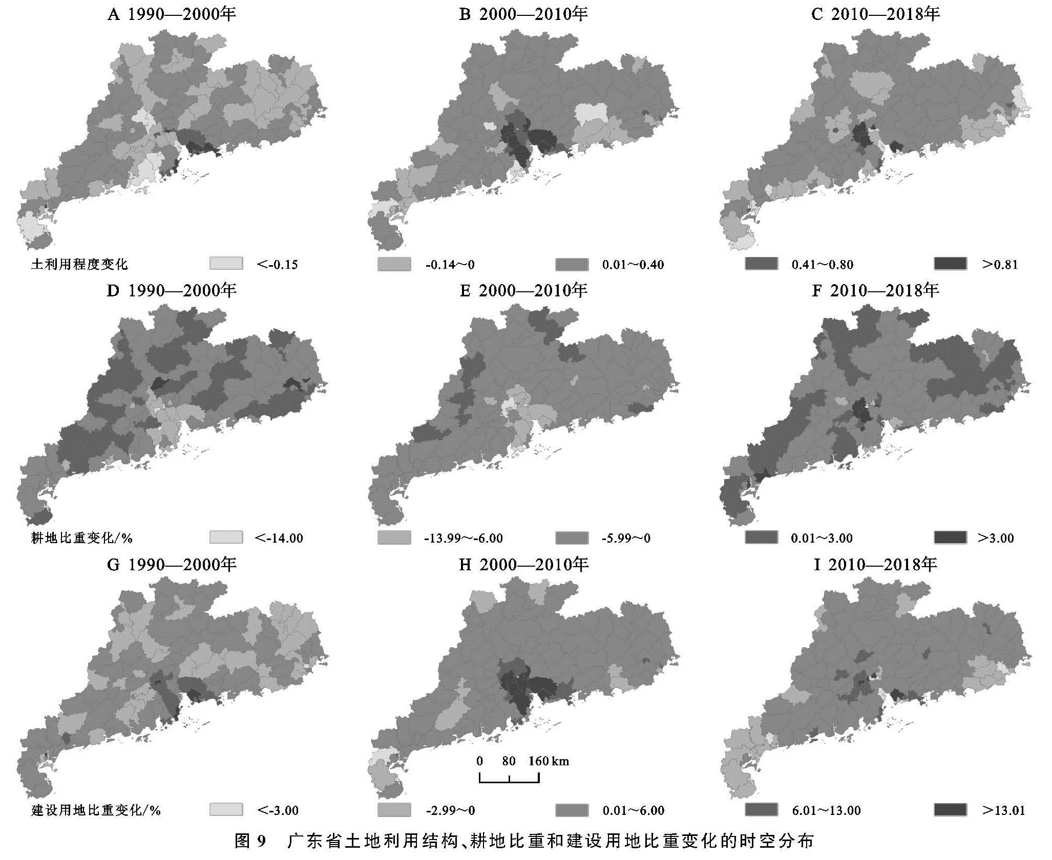
为了进一步揭示广东省土地利用程度、耕地比重和建设用地比重在1990—2000年、2000—2010年、2010—2018年的变化规律,本研究对它们的变化进行了空间分布作图(图9)。
图9 广东省土地利用结构、耕地比重和建设用地比重变化的时空分布
结果发现,1990—2000年广东省土地利用程度变化大于0.80的市区主要出现在珠江三角洲部分县区及西翼的湛江市赤坎区,小于-0.15的市区主要出现在珠江三角洲和西翼的个别县区; 然而耕地比重变化小于-14.00%区域主要分布在珠江三角洲中心区和西翼少部分区域,而其他区域大于-6.00%,少数县区大于3.00%; 建设用地比重变化大于13.00%的区域在珠江三角洲及东翼个别县区,小于-3.00%的区域主要在汕头市金平区。2000—2010年广东省土地利用程度变化普遍处于增加状态,其中珠江三角洲中心部分县区变化大于0.80,然而只有个别县区小于-0.15,耕地比重变化普遍处于降低状态,只有珠江三角洲个别县区小于14.00%,建设用地比重大部分处于增加状态,其中珠江三角洲的中心区部分县区变化大于13.00%,只有遂溪县小于-3.00%。2010—2018年广东省土地利用程度变化大部分处于增加状态,其中珠江三角洲个别县区变化大于0.80,变化低于-0.15的县区在沿海县区零星分布,耕地比重变化大部分处于轻度降低状态,其中只有广州市荔湾区变化小于-14.00%,然而北部和西部山区耕地比重有所增加,珠江三角洲中心个别县区变化大于3.00%,建设用地比重大部分处于增加状态,其中珠江三角洲中心个别县区变化大于13.00%,而个别县区小于-3.00%。