4.1 地形因素
贵州省属于典型的喀斯特山区,地形对农村居民点的规模、形态和密度等的分布都有着深刻的影响。而高程、坡度、地形起伏度作为农村居民点选址的重要参考条件,对农村居民点的空间分布影响最为直接[36]。因此本文选取高程、坡度、地形起伏度3个地形因子,运用景观格局指数来研究地形对居民点空间分布的影响,其中平均斑块面积、密度和平均形状指数分别代表规模、密度和形态特征。
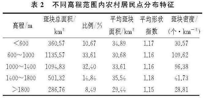
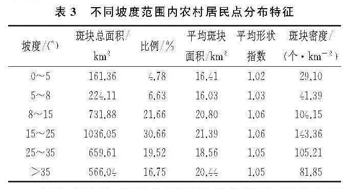
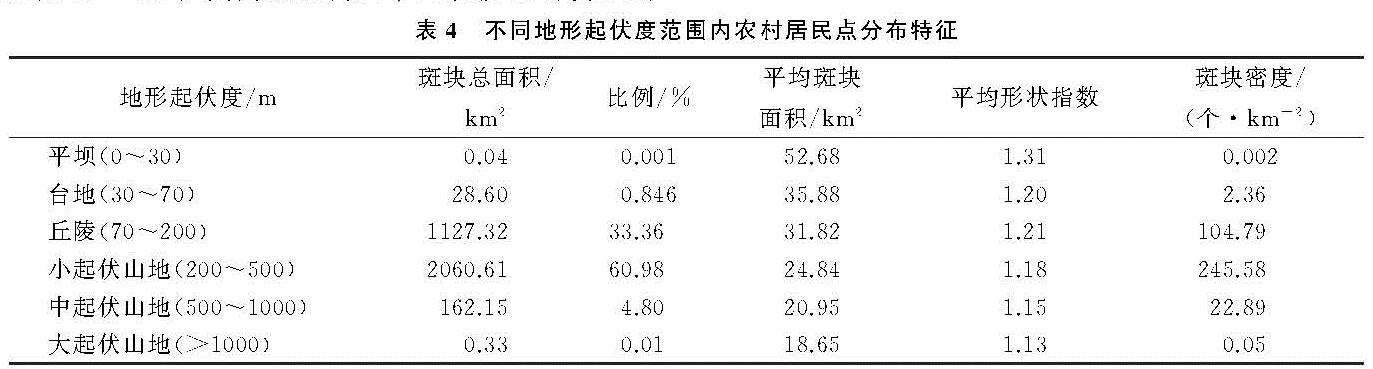
参考文献[37],以400 m为间距将贵州省的高程分为5个等级(表2),参考《贵州农业地貌区划》将坡度划分为6个等级(表3),并将地形起伏度划分为6个等级(表4)[38]。
由表2可知,全省66.01%的农村居民点分布在高程600~1 400 m内,且农村居民点在此区域内密度最高。高程小于600 m时,居民点的分布虽较少,但其平均规模相对其他高程较高; 高程>600 m时,农村居民点的面积和密度均呈现垂直递减规律,说明地势相对平坦的地区,人口承载力相对较高,但其平均规模和形态相反,均呈现先增大后减小的趋势。高程600~1 000 m内,农村居民点的分布最多,密度最大,形状也相对更规则,但平均规模相对较小,由高程分布可看出,该区间主要分布在黔中安顺、贵阳这一带,主要为丘原、盆地地貌区。而高程>1 800 m时,由于生产条件和居住环境相对较差,农村居民点的分布最少,平均规模小,密度低且形状规则。由农村居民点在高程带上的分布可以看出,其并没有表现出高程越低分布越多、规模越大、密度越高的现象,这是因为这些区域虽海拔低,但属于低山河谷地带,且大部分地区山势陡峻,峡谷深切,故居民点的分布相对较少、规模较小、密度较低。上述分析表明,高程对农村居民点的规模、形态和密度均有一定的影响,随着高程的增大,平均规模和形状指数均表现为跳跃性波动,但密度则表现为先增大后减小,说明高程对密度的影响最大,对规模和形态的影响较小。
由表3可知,随着坡度的增加,农村居民点的斑块总面积、形状指数和密度均呈现出先增加后减少的趋势,但平均规模随其增加则波动性较大。贵州省整体的坡度都较陡,根据《贵州农业地貌区划》可知,坡度在15°以下,分别为平坡、平缓坡和缓坡。平坡(0°~5°)和平缓坡(5°~8°)地面平坦,主要分布于平坝、河流阶地、山间盆地和台地、剥夷面上[39],在此坡度区间内,是基本农田分布区和农业机械化耕作适宜区域,为尽量保留耕地,一般不在此区间内建设居住区,故居民点的总面积、平均规模和密度均较低,且形状规则。坡度8°~25°范围内,居民点的分布有所增加,且在15°~25°范围内,总面积、平均规模和密度达到最大值,但形状相对复杂,这说明针对贵州特殊的地理环境,8°~25°坡度范围内为农村居民点选址的最佳区域。在坡度25°以上,随着坡度的增加,居民点的分布和密度开始减小,形状更为复杂。由此可见,坡度也对农村居民点的规模、形态和密度产生一定的影响,但影响程度不一样。由三者随坡度的变化趋势可看出,坡度对形态和密度的影响程度大于对规模的影响。
由表4可知,随着地形起伏度的增加,斑块总面积和密度均表现为先增大后减小的趋势,但平均规模却随着其增加反而减小,形状指数则随其变化的波动性较强。贵州省94.34%的农村居民点位于地形起伏度为70~500 m区间上,其中33.36%位于地形起伏度为70~200 m的台地上,60.98%位于地形起伏度为200~500 m的小起伏山地上,居民点平均规模较大,密度高且形状相对复杂。位于地形起伏度大于500 m的则不到5%,居民点的平均规模小,密度低且形状相对规则。除此之外,地形起伏度小于70 m的仅有0.847%,密度低,但居民点的平均规模大且形状复杂。由此可见,贵州省农村居民点的规模受起伏度的影响最大,起伏度越小,规模越大; 其次受影响较大的则为总面积和密度,起伏度太低或太高,总面积和密度均很小,大面积密集区主要在丘陵和小起伏山地区; 而受影响最小的为形态。其总面积和密度并没有表现出地形起伏越小,值越大的情况,这主要是因为平坝和台地所在区基本都是临近水域或者是水域所在区,故居民点的分布较少且分散。
上述分析表明,高程、坡度与地形起伏度均对农村居民点的规模、密度、形态产生一定的影响,高程对农村居民点的密度影响较大,对规模和形态的影响不太明显; 坡度对密度和形态的影响较大,但对规模的影响较小; 地形起伏度则对规模、密度的影响较大,对形态影响较小。
4.2 区位因素
由前文分析可以知道,农村居民点的分布与交通和城镇发展有着密切的关系,而水源作为人类生存与农业生产的基本条件,对喀斯特山区居民的生产和生活尤为重要。为进一步分析交通、城镇和水源对喀斯特山区农村居民点规模、形态、密度分布的影响,本文基于交通、水域和城镇地理要素,通过景观指数和空间可达性方法,对居民点在不同地理要素的不同可达性范围内分布特征进行分析。
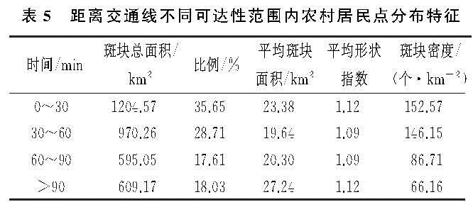
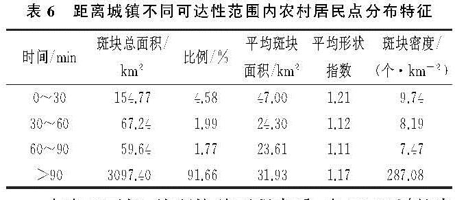
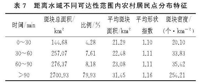
为客观反映区位对居民点空间分布的影响,分别测算农村居民点在交通(农村道路和公路)、水域(河流、水库和湖泊)、城镇(城市和建制镇)的空间可达性,然后将农村居民点与交通、水源和城镇的可达性叠加,统计其不同可达性范围内农村居民点的分布特征(表5—7)。
由表5可知,在距离交通线不同可达性范围内,农村居民点的分布、平均规模、密度和形态表现出不同的差异。其主要分布于0—30 min和30—60 min内,分别占全省农村居民点的35.65%和28.71%,总体上呈现递减的分布态势; 随交通可达性成本的增加,居民点的平均规模表现为先减小再增大,形态表现为“凹”字形分布,密度则表现为一直减小。由此可见,喀斯特山区农村居民点的规模、形态和密度均对交通具有一定的依赖性,且由规模、形态和密度在可达性成本上的分布可以看出,交通对密度的影响程度高于规模和形态。
表5 距离交通线不同可达性范围内农村居民点分布特征
由表6可知,农村居民点有91.66%分布在可达性>90 min内,且在该区域内居民点的斑块密度最大,形态也相对更规则。在可达性90 min内,农村居民点的分布虽不到10%,但其平均规模、形状指数和密度在可达性30 min内,明显高于可达性30~90 min。随着城镇可达性成本的增加,其平均规模、形状指数以及密度相应减小,所以城镇的可达性越高,农村居民点的规模越大、形状越复杂、分布越密集。由此看出,城镇对农村居民点的规模、形态和密度的影响均较大。
由表7可知,从斑块总面积来看,有79.93%的农村居民点分布在水域可达性>90 min范围内,且随着可达性程度的降低,农村居民点的平均规模、形状指数及密度也在增加。在可达性90 min内,仅有20.07%,居民点分布少,密度较低,但形状相对规则,其主要受喀斯特地貌的影响。水域一般多位于河谷深切,山势陡峻,地形复杂的区域,可达性较低,在一定程度上不利于人们的生产生活。由此可知,水域对农村居民点的规模、形态和密度分布具有一定的影响,但其影响不同于城镇和交通,随着其可达性成本的增加,农村居民点的规模增大,形态越复杂,分布更密集。
由表5—7可以看出,交通、城镇、水域均对农村居民点的规模、密度和形态产生一定的影响。其中,交通对规模和形态的影响低于其对密度的影响; 城镇和水域对三者的影响均较大; 城镇和水域的影响则相反,离城镇越近,其规模越大、形状越复杂,分布越密集,而离水域越近,其规模越小,形状越规则,分布越分散。
4.3 社会经济因素
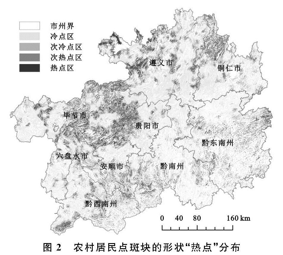
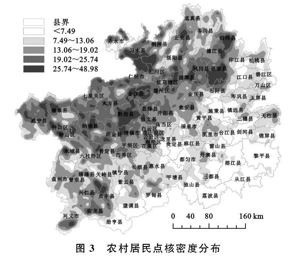
农村居民点的形成受多种社会经济因素的影响,其中人口、民族、经济、政策等对贵州省居民点分布有着重要的影响[40]。人口和民族会对农村居民点的规模和形态产生一定的影响。农村居民点建设的首要目的就是满足村民的居住需求,农村人口越多,其对居民点的需求便越大,其中毕节市最为典型,毕节市农村人口在全省居第一位,而其农村居民点的面积也在全省位居第一。贵州省是一个多民族共居的省份,根据2010年全国第六次人口普查数据,少数民族占总人口的35.70%,居全国第三位[41],有苗族、布依族、侗族等17个世居少数民族。不同的少数民族,其在居住喜好方面也有所不同,比如苗族、布依族、水族多喜好成片聚居,单家独户零散居住者少,而仡佬族的居住地,大多交通不便,地少而土瘠,故散居的居多,这对农村居民点的规模和形态都产生了很大的影响。黔东南、黔西南、黔南州属于苗族、布依族的主要聚居区,北部遵义市的道真县与务川县是仡佬族的主要聚居地,结合面积(图1)和形状“热点”分布(图2)可知,黔东南、黔西南、黔南州各县域的规模明显要比道真县与务川县大、形状更复杂。
经济会对居民点的形态和规模产生的一定的影响,一般经济越发达的地方其交通、文化各方面都会较好,居民点的聚居性越强,规模也会更大一些,且由于这些区域规划管理较好,其形状也会更规则,比如贵阳、遵义市中心区一带。而经济相对落后的区域,比如毕节市、黔西南州和黔南州交界处的县域,这些县域大部分为贫困县,其中一部分更是深度贫困县,由农村居民点面积(图1)和形状“热点”分布(图2)可知,其居民点呈现出规模小而形状复杂特点。
政策制度通过一定的方法控制着农村居民点的形成与发展。近年来,贵州省由于经济条件不断变好,外出务工人员返乡,使得农村常住人口增加,农村居民随意占用土地修建宅基地的现象越来越突出,为减少耕地侵占、守住耕地红线,政府通过出台一系列政策来规范居民的居住选址行为。其中,易地扶贫搬迁、生态移民政策、迁村并镇等政策的实施,对居民点的规模、形态和密度均产生了一定的影响。