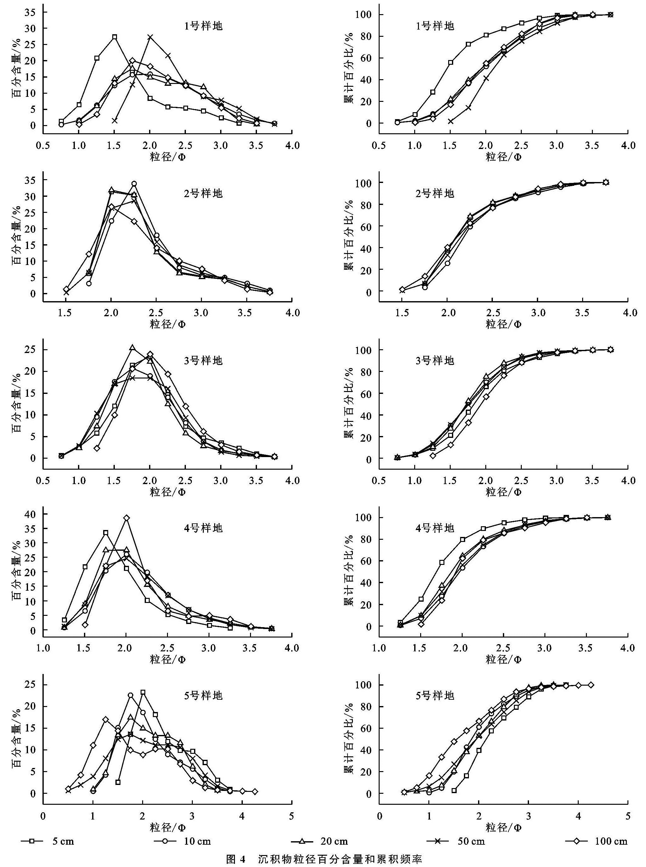
4.1 沉积物空间分布
如图4所示,1号采样点5 cm深度处沉积物的粒径主要分布在1.26~1.76 Φ,百分含量为65.03%。随着深度的增加,上述范围内的颗粒百分含量有增加趋势,分别为70.68%,84.69%,74.03%,78.46%,且分布范围扩大至1.5~2.76 Φ,但平均粒径呈减小趋势。进一步分析不同深度沉积物百分含量分布曲线可知5 cm和50 cm沉积物的百分含量分布曲线峰形较窄,其余深度沉积物分布曲线峰形较宽,但均为单峰态分布。从累计百分比曲线可以看出,5 cm和50 cm深度处沉积物的累计百分比增长速率最快,斜率最大,表明该深度的土壤粒径分布最为集中。
与1号采样点沉积物百分含量分布曲线相比,2号采样点沉积物分布曲线也为单峰态分布,但峰态较1号窄,粒径分布范围也存在差异。其中,5 cm深度处沉积物粒径范围集中在2.0~2.51 Φ,百分含量为74.71%,其余深度分布范围集中在1.76~2.76 Φ,分布范围较1号点宽,百分含量集中在70.77%~85.33%。与1号采样点累计百分比曲线相比,2号采样点所有深度沉积物的累计百分比曲线相似性较1号高。
3号采样点粒径分布范围集中在1.25~2.5 Φ,4号采样点粒径分布范围集中在1.5~2.5 Φ,均为单峰态分布。3号采样点不同深度沉积物的累计百分比曲线差异性较小, 4号采样点5 cm和100 cm深度处的沉积物粒径分布相对集中,其他深度沉积物累计百分比曲线相似性较高。
5号采样点沉积物粒径分布范围较上述4个采样点宽,分布范围为1.0~2.76 Φ,但粒径分布曲线相似性较高。受区域内植被影响,5 cm和10 cm深度沉积物百分含量分布曲线呈单峰态,20,50,100 cm深度沉积物粒径百分含量分布曲线呈双峰态。分析累计百分比曲线可知20,50,100 cm处累计百分含量图中出现两次斜率陡增,拐点均为粒径分布的峰值处。
综上可知,上述所有采样点粒径范围集中在1.0~2.76 Φ,即所有颗粒均属于沙,以细沙和中沙为主,不含粉沙和砾石。除5号采样点部分深度沉积物百分含量分布曲线呈双峰态,其余均为单峰态,峰形较窄,说明沉积物经过了充分分选,离物源区相对距离远。5号采样点从表层至深层粒径百分含量分布曲线由单峰态逐渐过渡为双峰态,说明区域风况发生过改变,由早期两组主导风向转变为近期的单组风向。
4.2 沉积物垂直分布
分析不同采样点相同深度沉积物粒度特征可知(图4):5个采样点相同深度沉积物百分含量分布曲线和累计百分比曲线存在差异。以5 cm深度沉积物百分含量分布曲线为例,1号、2号和4号沉积物百分含量分布曲线呈单峰态,峰形略窄,3号采样点百分含量分布曲线峰态较宽,5号采样点为双峰态分布。分析峰值所对应的粒径大小,可知2号、3号和5号采样点峰值处粒径最大,4号采样点其次,1号采样点最小。
与5 cm深度沉积物百分含量分布曲线趋势相比,1号、3号和5号采样点10 cm深度处沉积物百分含量分布曲线峰态平缓,即沉积物粒径分布范围较广,分选性较差,2号和4号采样点10 cm深度处沉积物粒径分布范围较窄,沉积物粒径分布较为集中,优势粒径位于2.25 Φ。
1号和5号采样点20 cm深度处沉积物土壤粒径分布规律存在相似性,两者分布相对集中,如1.5~2.76 Φ粒径范围百分含量分别为84.69%,84.06%。其他采样点20 cm深度处沉积物粒径则集中分布在1.5~2.5 Φ。除5号采样点50 cm和100 cm深度处沉积物百分含量分布曲线呈双峰态,其余均呈单峰态分布。
4.3 粒度参数
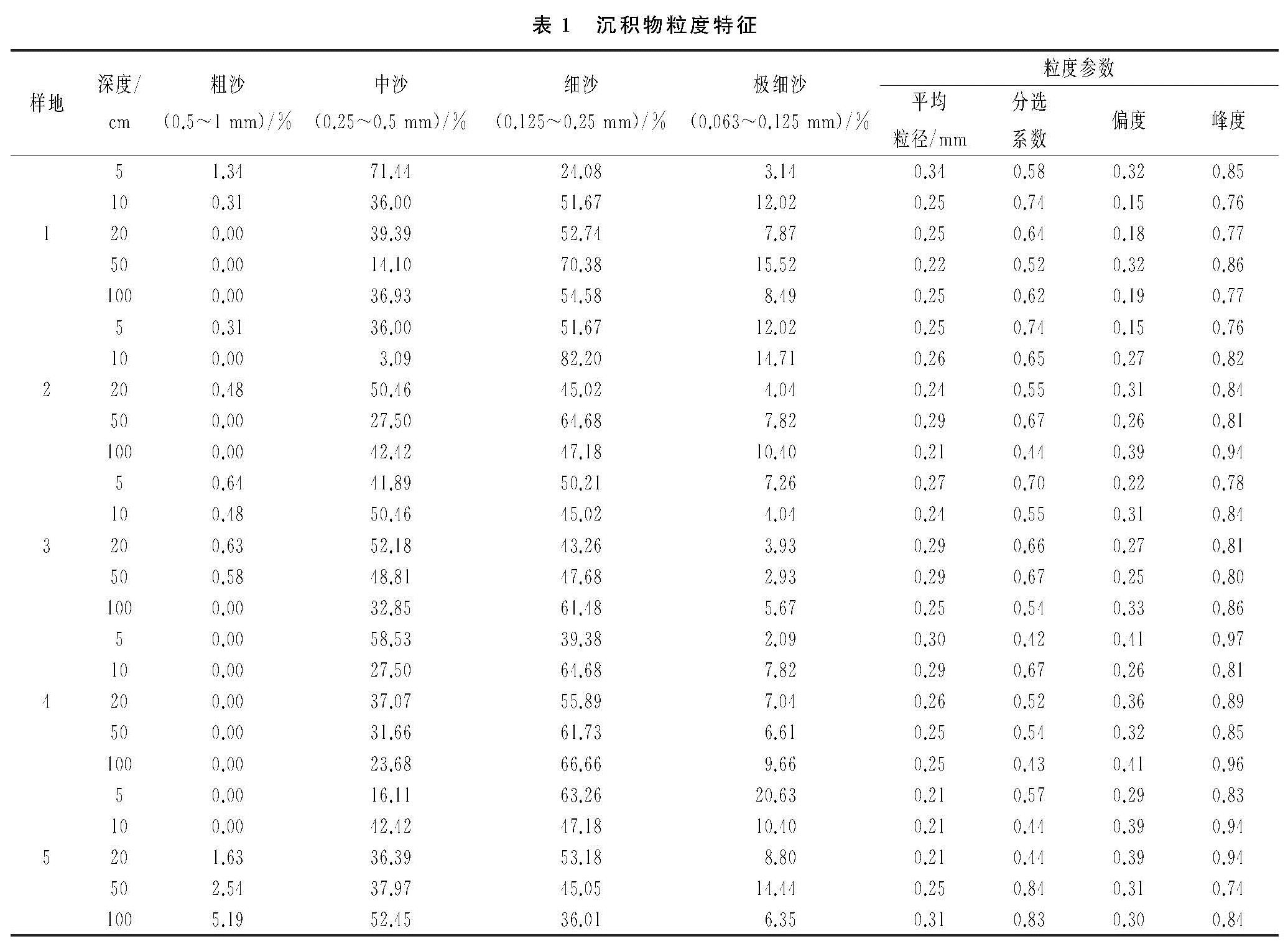
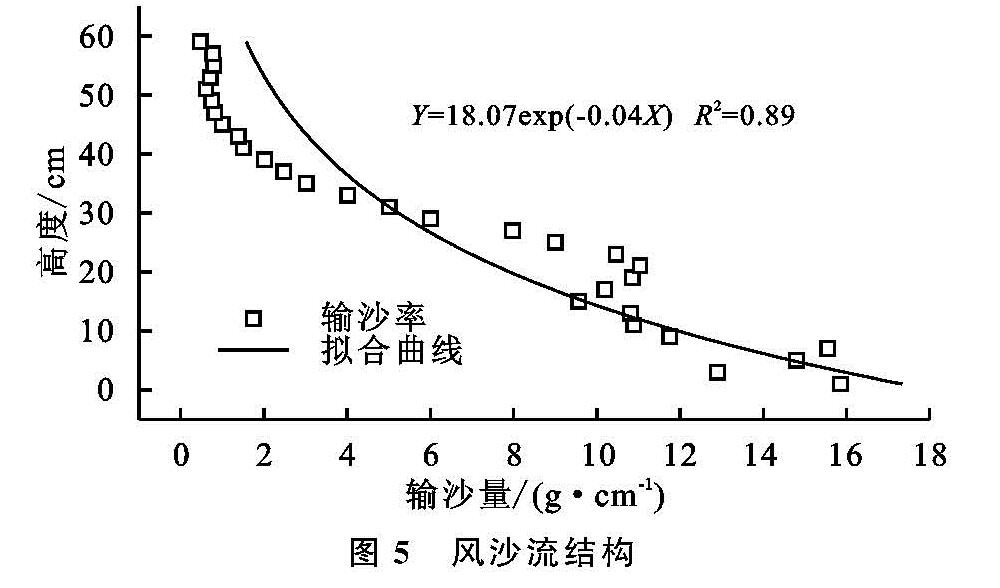
平均粒径、分选系数、偏度和峰度是沙粒的基本参数特征,是解析风沙环境的重要参考[11],见表1。通过分析各样品粒度参数可知,1号采样点除5 cm深度处沉积物以中沙为主,其余以细沙为主。随着深度的增加,粗沙比例逐渐减小,20 cm深度后粗沙消失。除5 cm深度处沉积物中沙百分含量为71.44%和50 cm深度中沙百分含量为14.1%外,其余深度沉积物中沙百分含量均维持在30%左右。细沙和极细沙含量随深度增加呈现先增加后减少趋势,50 cm深度处,细沙和极细沙百分含量最大,分别为70.38%,15.52%。沉积物平均粒径随着深度增加逐渐变小,分选性和峰度则无明显变化规律,分选性均为较好,偏度为正偏,峰态属于宽峰态。
2号采样点以细沙为主,粗沙含量极少。随着深度的增加,中沙百分含量呈上升趋势,细沙百分含量呈下降趋势,极细沙含量与深度无明显相关性。与1号采样点相比,2号采样点平均粒径偏小,说明此地区沉积物受风力侵蚀较弱,样品分选性除10 cm深度分选性最差外,其余沉积物分选性很好,偏度为正偏和极正偏。
3号采样点沉积物以中沙和细沙为主,沉积物平均粒径介于0.24~0.29,与深度相关性较小。除5 cm深度处沉积物分选性中等,其余分选性好或较好,正偏或极正偏,宽峰态分布。
4号采样点仍以中沙和细沙为主,且细沙含量大于中沙。随着深度的增加,中沙百分含量逐渐减小,细沙百分含量增加,说明此处前期风力侵蚀能力较弱,后期风能环境增强,粒度变粗。沉积物平均粒径随深度增加逐渐变小,沙粒逐渐变细。分析粒度参数可知10 cm、20 cm和50 cm深度处沉积物分选性较好,5 cm和100 cm深度处沉积物分选性很好,百分含量分布曲线为宽峰和中等峰态。
5号采样点5 cm深度处沉积物以细沙为主,占比为63.26%,极细沙百分含量是所有样品的最大值,达到20.63%。除100 cm深度处沉积物以中沙为主外,10 cm、20 cm和50 cm深度处沉积物均以细沙为主。各粒级百分含量随深度无明显变化规律,分选性随深度先变好后变差,表明区域风沙环境存在一定变化。50 cm深度处沉积物为对称分布,其余为极正偏分布,峰态为宽峰或常峰。