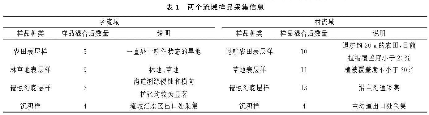
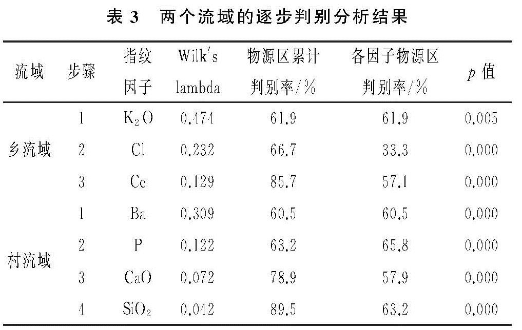
3.3.1 不同源区的泥沙相对贡献率
根据最佳指纹因子组合中各因子的物源区和沉积区泥沙样品中的浓度,利用Walling-Collins模型计算不同物源区的泥沙相对贡献率。农田表土和退耕农田表土分别是乡流域和村流域主要的泥沙源区。在乡流域,农田表土对沉积泥沙的贡献比高达71.6%,是第二源区林草地表土(15.9%)的4.5倍,第三源区侵蚀沟仅贡献了12.5%的泥沙。在村流域,退耕农田表土、侵蚀沟和草地表土的泥沙贡献比差距相对小一些,分别占比44.4%,34.2%,21.4%。
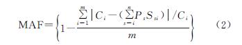
为了检验计算结果的稳定性,使用平均绝对拟合度值(mean absolute fit,MAF)评估模型(公式4)对计算结果进行了评估,乡流域和村流域两个研究区的泥沙来源的MAF分别为0.97,0.98,远高于0.8的临界可接受值,表明Walling-Collins模型对两个流域泥沙贡献率的计算结果是可靠的。
3.3.2 不同源区的泥沙面积比
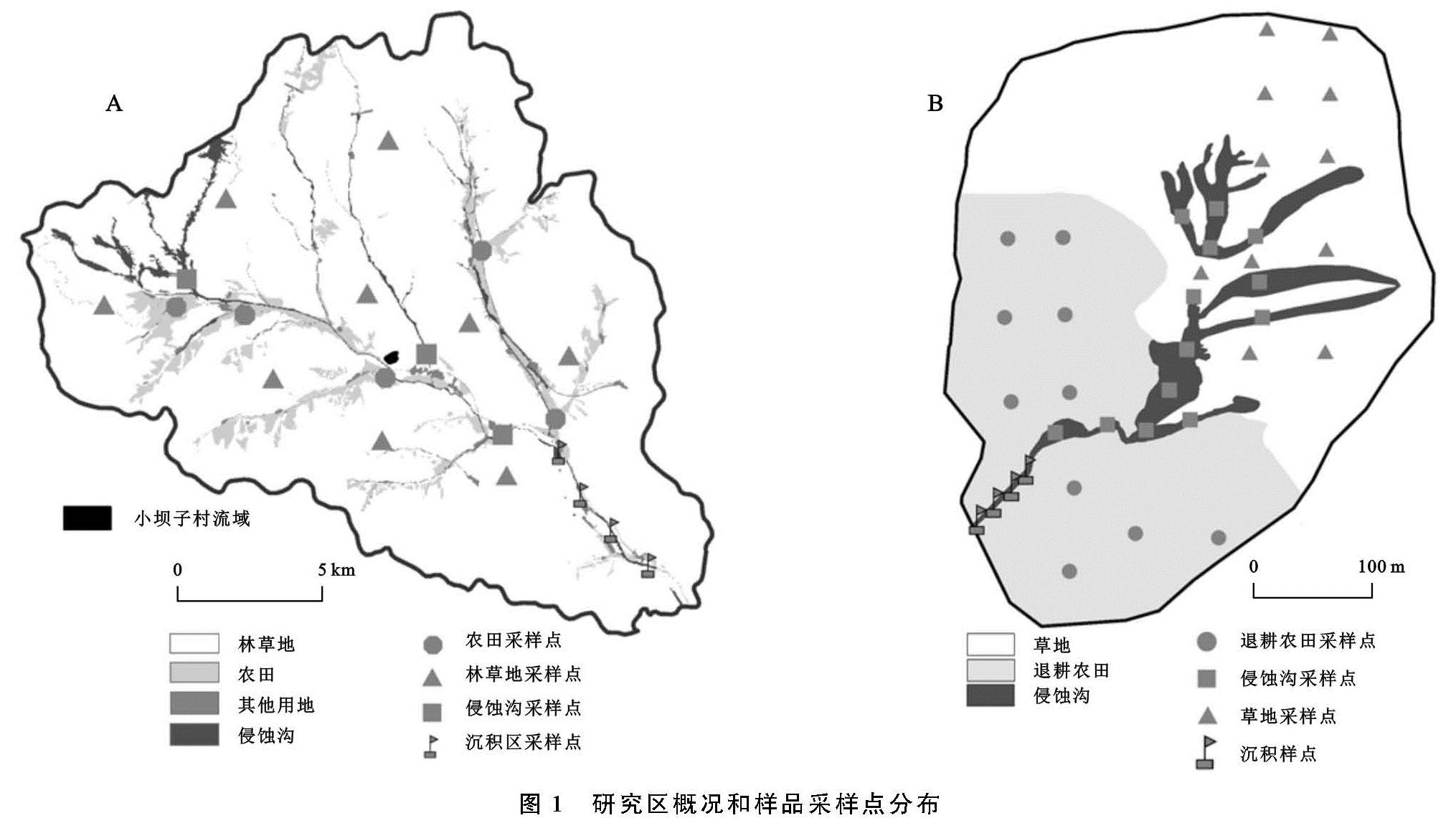
为明确不同土地利用类型在流域内的面积占比与泥沙贡献比的关系,利用样品采集当年(2018年)的遥感影像对流域土地利用类型进行了解译。由于小坝子乡土地利用类型比较复杂,解译过程中参照《区域水土流失动态监测技术规定》,依据土地利用二级分类标准进行,解译结果见图1和表4。
由图1和表4可知,乡流域土地利用类型以林地和草地为主,占总面积的90.21%,其次为农田,占比6.47%,侵蚀沟占比2.13%,剩余为建设用地等其他用地。村流域的退耕农田和草地分别占比41.38%,57.26%。根据现场调查,结合无人机影像,确定的侵蚀沟面积为0.014 2 km2,面积占比8.64%。
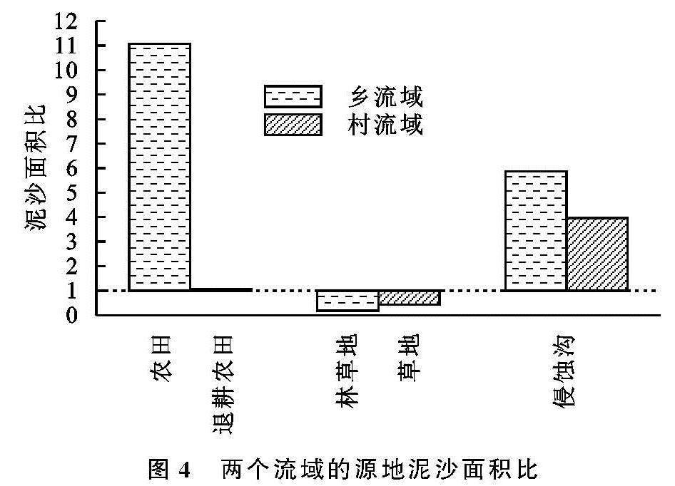
为反映各源区泥沙输移沉积的严重程度,引入泥沙面积比来定量表达各侵蚀源区泥沙搬运至流域出口沉积区的比例和其所占流域面积的比例,定义为这两个比例的比值。当比值结果大于1时,表明流域内该类型物源区流失土壤的比例偏高,相应地,土壤侵蚀强度也越高; 反之,表明流域内该类型物源区流失土壤的比例不是很严重,值越接近于0,土壤流失后搬运至沉积区的比例越少。
由图4可见,除乡流域的林草地和村流域的草地表土泥沙面积比小于1外,其他4个侵蚀源区的泥沙面积比均高于1。尤其是乡流域的农田表土泥沙面积比高达11.07,其土壤侵蚀、搬运的比例远高于村流域退耕农田表土泥沙面积比的1.07。一方面,这可能与农田在人为扰动后,表土变得疏松,从而更易于流失有关。每年的雨季也恰是农田的除草季,相比于退耕农田,农田的人类活动干扰更加强烈,由此导致表土更容易被侵蚀掉。另一方面,从农田在乡流域的分布来看,大多集中在下坡位,距离沟道较近,受水系连通性强的影响,表土侵蚀后更容易被水流搬运至河道中,从而其在流域出口沉积的概率也更高。
乡流域和村流域的侵蚀沟泥沙面积比分别为5.87,3.96,表明该研究区域的侵蚀沟不断扩张发育导致的底层土壤流失是不容小觑的。侵蚀沟的快速扩张使坡面径流和泥沙更加容易在沟道内汇聚,从而增大了流域内泥沙输移的连通性,间接加剧了土壤侵蚀后的输移比例。乡流域的林草地和村流域的草地泥沙面积比分别只有0.18,0.43,与林草地植被覆盖度总体较高,能够增加泥沙拦截,从而降低侵蚀搬运量有关。
从上述结果来看,村流域后续的水土流失治理重点应着眼于侵蚀沟,乡流域除了侵蚀沟外,还要重视农田的水土流失防治,实施以工程措施、生物措施和耕作措施相结合的综合治理模式。具体来说,在主沟道中修建淤地坝,支沟中修建梯级谷坊,进行分段控制,并在沟头植树种草减缓溯源侵蚀。坡耕地应减少雨季扰动的频次和强度,通过免耕、等高耕作等措施降低水力侵蚀的危害。