3.1 广东省耕地生态承压能力时序变化特征分析
根据公式(1)—(3),分别计算2008—2017年广东省耕地生态足迹、耕地生态承载力、耕地生态盈亏(图2),并分别计算相应的人均耕地生态足迹总量、人均耕地生态承载力总量、人均耕地生态赤字(表2)。
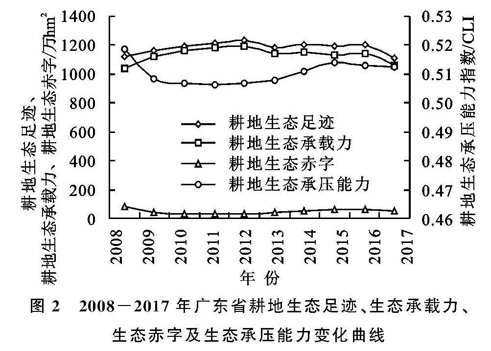
图2 2008-2017年广东省耕地生态足迹、生态承载力、生态赤字及生态承压能力变化曲线
表2 2008-2017年广东省人均耕地生态足迹、生态承载力及生态赤字计算结果
由图2可知,2008—2017年广东省耕地生态足迹变化总体呈“雁行”波动下降趋势。大致可划分为两个阶段:第一阶段为2008—2012年,耕地生态足迹连续小幅度上升,但增长幅度呈逐年下降的趋势; 第二阶段为2013—2017年,期间耕地生态足迹波动下降,并在2013年出现波谷,2016—2017年的降幅相对较大。其次,广东省的耕地生态承载力的总体变化趋势与耕地生态足迹相似。2008—2011年期间,耕地生态承载力以单调递减的增幅上升,但其变化幅度略大于同期的耕地生态足迹; 2012—2017年期间耕地生态承载力于呈现波动下降,该阶段的波峰出现在2014年。此外,研究期内广东省的耕地生态承载力供需平衡一直处于生态赤字状态。耕地生态赤字额在2008—2015年呈现先减后增的趋势,并在2011年达到研究期间的最低值为299 250.660 7 hm2,耕地生态赤字于2015年停止增长且由增转降; 10 a间,广东省的耕地生态赤字总量减少了133 663.090 9 hm2,降幅约为1.19%,表明农业生产活动超出了耕地生态承载力范围,人地矛盾紧张仍是困扰耕地生态系统不可持续性的重要原因。
根据公式(4),计算耕地承压能力指数,并绘制耕地承压能力指数变化曲线(图2),研究结果表明,研究期内广东省耕地承压能力指数介于0.500~0.520,说明广东省耕地生态承压能力在研究期内均处于弱不可持续状态。2008—2017年广东省耕地承压能力呈先降后升再降的整体发展态势。其中,2008—2011年耕地承压能力指数呈递减趋势并达到研究期最小值,说明该期间广东省耕地生态承压能力逐渐增强; 2012—2015年期间耕地承压能力指数单调递增,生态可持续能力不断下降; 2016—2017年的耕地承压能力指数变化显示广东省的耕地生态承压能力有所改善,且该不可持续状态呈进一步减弱态势。
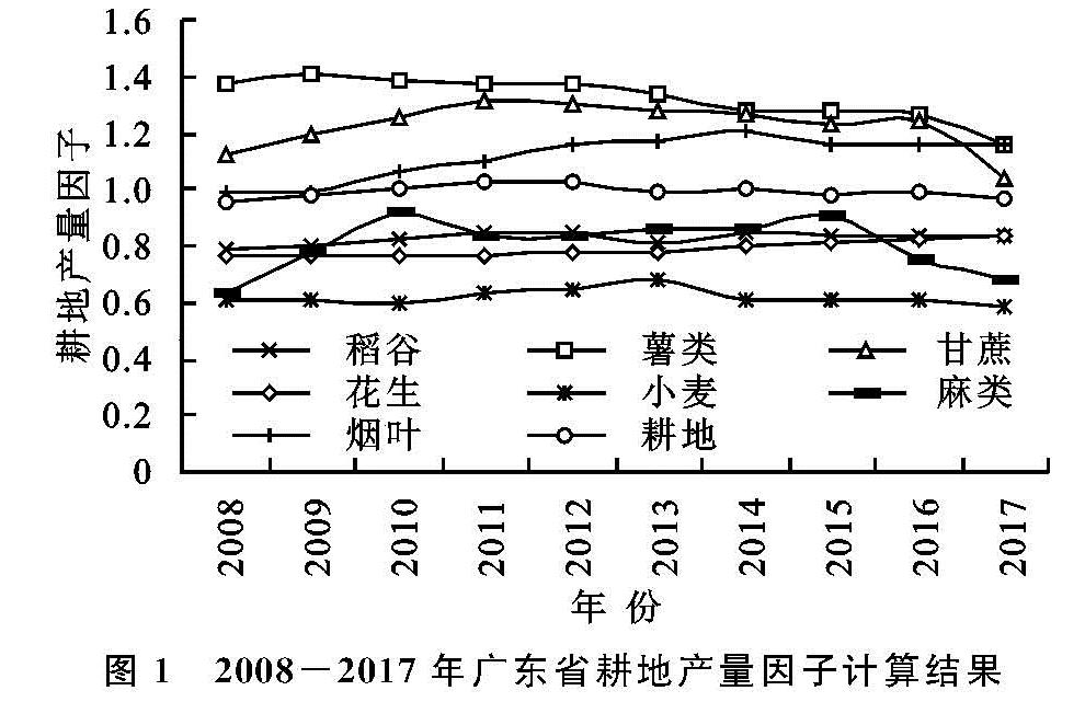
作为生态消费需求来源的人口是影响耕地承压能力的重要因素。由表2可知,广东省由于人口基数大,导致人均耕地生态足迹、人均耕地生态承载力均低于国家(0.52,0.38 ghm2/cap)和世界(0.59,0.57 ghm2/cap)的平均水平[37]。2008—2017年广东省人均耕地生态足迹、人均耕地生态承载力、人均耕地生态赤字均呈下降趋势,表明近年来广东省人口负荷对耕地生态的影响有所缓解。其次,通过对比2008—2017年期间广东省年常住人口变动与广东省耕地承压能力指数曲线的情况,发现两者同期的变化趋势大体上一致。在2008—2012年期间,为满足因人口增长等因素引起的耕地生态供给需求增加,广东省包括粮食作物在内的等多种耕地作物相应增加了播种面积从而提高生产量; 而2012—2017年期间在耕地面积和耕地作物播种面积减少的情况下,2017年的耕地生态承载力较2008年略有上升,说明广东省耕地的单位生产能力有所提升。2008年广东省的耕地面积约为2 830 732.00 hm2,2017年下降至2 601 135.14 hm2,耕地减少的面积相当于2008年广东省耕地面积的8.11%,即耕地面积平均每年减少了约22 959.69 hm2。而城市、建制镇、村庄用地面积在10 a间分别增加了53 866.67,105 733.33,42 866.67 hm2,增长率分别为18.52%,36.19%,5.44%。2011—2014年,广东省建设用地占用耕地约2.51万hm2,其中,24.70%为优等质量耕地,73.31%为高等质量耕地,1.99%为中等质量耕地。可见,广东省耕地生态赤字的实质一定程度上是耕地生态承载力不足。一方面需要正确处理经济发展、城镇化与耕地保护之间的关系,保证基本农田面积不减少、耕地质量不下降; 另一方面需要提高耕地承载能力,由耕地产量因子的计算结果可知,稻谷、薯类、甘蔗、花生、小麦、麻类、烟叶的平均年产量因子分别为0.829 0,1.323 8,1.224 9,0.789 1,0.616 8,0.805 7,1.114 5,其中稻谷、花生、小麦的产量因子水平偏低,而小麦在广东的种植面积极小,稻谷、花生分别为广东省主要的粮食作物和油料作物,因此,可以通过改造中低产耕地、高标准农田建设、提高农业科学技术水平等方式提高耕地的综合生产能力。
3.2 广东省耕地生态承压能力空间变化特征分析
根据公式(1)—(3)分别计算2008年、2012年、2017年广东省21个地级市耕地生态承压能力指数,其中,考虑到新成立的深汕合作区,原位于汕尾市陆丰县的深汕合作区与深圳市在地理上并不接壤,故将深汕合作区2017年的统计数据合并到汕尾市2017年的统计数据中进行计算。由计算结果可知,3个时间节点广东省各地级市耕地生态承压能力指数的取值范围均处于0.440~0.600,对照表1可知,广东省各地级市的耕地生态承压能力指数均属于弱可持续和弱不可持续两大类型。2008—2017年耕地生态承压能力为弱不可持续类型的地级市数量占比较大,由2018年的14个减少到2012年的11个,2017年则增加到15个,表明广东省各地级市的耕地生态承压能力状态有待提升,耕地生态可持续发展呈现退化态势。
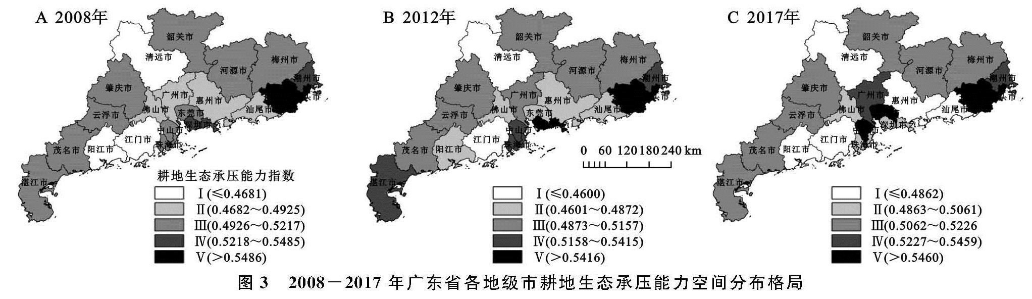
为探知广东省耕地生态承压能力的空间分布状况,借助ArcGIS 10.2软件,运用自然断裂点法将2008年、2012年、2017年广东省各地级市耕地生态承压能力指数由小到大依次划分为Ⅰ,Ⅱ,Ⅲ,Ⅳ,Ⅴ共5个等级(图3)。由图3可知,广东省耕地生态承压能力分布年际间存在差异,但各地级市的耕地生态承压能力指数变动幅度较小,整体空间格局维持相对稳定。从各类型分布数量及分布区域来看,Ⅰ级类型区由2008年的清远市、江门市、阳江市3个区域减少至2012年的清远市、江门市2市,2017年增至清远市、江门市、阳江市、惠州市、汕尾市5市,分布区域逐渐扩大; Ⅱ级类型区主要分布在珠三角地区,由原来的佛山市、广州市、惠州市、汕尾市4个区域减少至仅佛山1个区域; Ⅲ级类型区域分布范围较广,主要分布在茂名市、云浮市、肇庆市、韶关市、河源市、梅州市等区域; 耕地生态承压能力较大的Ⅳ级、Ⅴ级类型区域则于粤东的潮州、汕头、揭阳三市稳定分布。
图3 2008-2017年广东省各地级市耕地生态承压能力空间分布格局
究其原因,汕头市、揭阳市因耕地生态环境质量、耕地亩产水平、人均耕地面积较高使得耕地生态承压能力一直处于广东省前列。而地处珠三角地区的广州市、中山市、珠海市、东莞市、深圳市耕地生态承压能力明显有所下降。生态足迹来源于人口生态消费需求,人口的增加及人类活动的影响形成巨额的生态足迹,相应地需要占用更多面积的土地作为耕地。珠三角地区作为广东省经济最为发达、人口基数大、人口密度高的地区,珠三角城市群的城镇化水平在广东省乃至全国名列全茅,以第二产业、第三产业为经济支柱,主要土地利用类型为建设用地,非农用地比重大,耕地面积占比低、总量小。以深圳市、中山市为例,深圳市、中山市两个地级市的人均耕地面积都远低于同期的省平均水平,但中山市的耕地生态承压能力有所下降,而深圳市的耕地生态状况则相对改善。通过对比可知,深圳市常住人口数量仅次于广州,而耕地面积为全省最少,2008年深圳市的耕地面积为4 078.00 hm2,而常住人口总量为954.27万人; 截至2017年,深圳市的耕地面积为3 742.06 hm2,常住人口数量为1 245.27万人; 人均耕地面积由2008年的4.17 hm2/万人降至2017年的3.00 hm2/万人。另一方面,深圳市耕地生态环境的相对改善一定程度上得益于新行政区建立带来的面积扩张及低于全省平均水平的耕地面积减少率。而中山市的耕地生态承压指数上升与其耕地面积的减少有较大关系。中山市的耕地面积在10 a内减少了约66.33%,耕地面积减少的绝对数量和减少比例均为全省第一并远超其他地级市。在人口数量方面,深圳市10 a间人口增加了291万人,增长率约为29.25%,而中山的人口增加数量和增长率分别为44.05万人和14.86%,在绝对数量和增加比例方面远低于深圳市,这也是二者存在差异的原因。因此,受人口增加、城镇化进程加快、耕地面积增减、机械化水平、农药化肥施用等各种人类活动因素的影响,对耕地生态产生着或多或少的负荷,加之人类本身对耕地生态环境保护的力度不够,使得耕地生态承压能力处于低水平状态,人类活动监管及耕地生态可持续性有待进一步加强。
3.3 广东省耕地生态承压力空间自相关分析
3.3.1 广东省耕地生态承压能力全局自相关分析
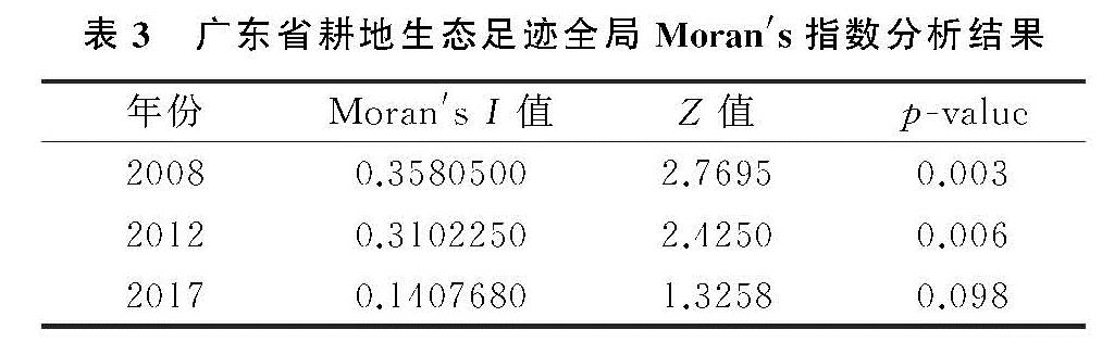
运用ArcGIS 10.2对研究期内广东省耕地生态承压能力指数(CLI)的全局Moran's I指数及Z值进行计算(表3),3个时间节点广东省耕地承压能力指数的全局Moran's I指数均为正值,分别通过5%,10%的显著性检验,说明2008—2017年广东省耕地生态承压能力在空间上存在显著的正相关性,空间聚集分布现象较为明显,即耕地生态承压能力指数较高及较低的地级市在地理空间上显著聚集,但随着时间推移Moran's I值不断减小,广东省耕地生态承压能力在地理空间上的集聚现象有所减弱。
表3 广东省耕地生态足迹全局Moran's指数分析结果
3.3.2 广东省耕地生态承压能力局部自相关分析
全局自相关分析仅能测度研究区域内耕地生态承压能力的整体空间集聚现象,无法测度研究区域内耕地生态承压能力的局部空间异质性。鉴于此,借助GeoDa软件,绘制生成Moran散点图,以揭示分析广东省耕地生态承压能力的局部空间异质性。
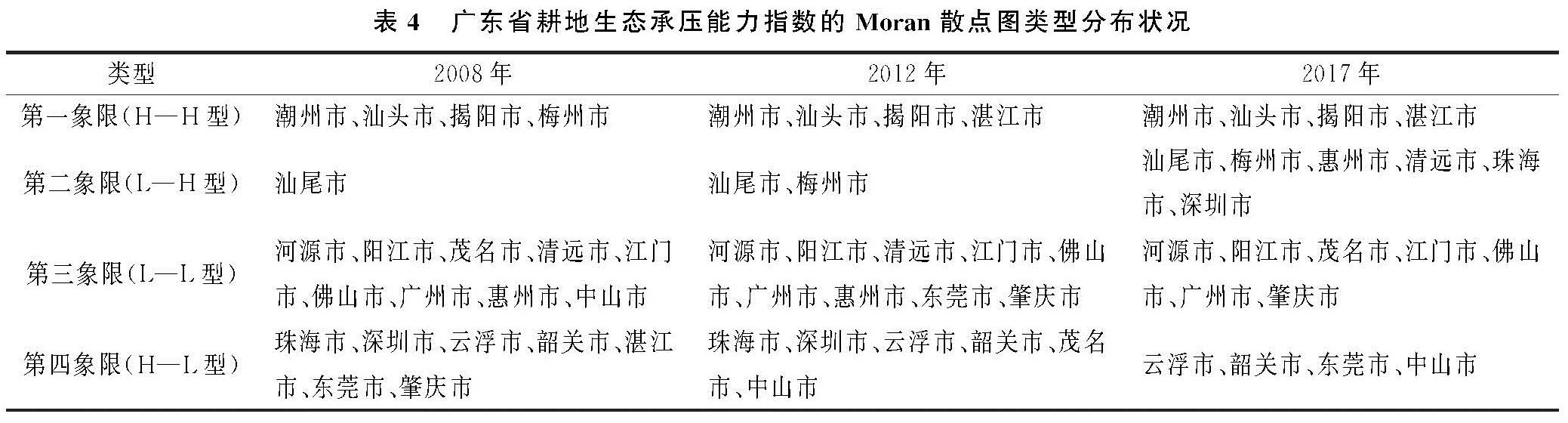
由图4可知,2008年、2012年的散点图点分布较为相似,主要集中分布在第一象限和第三象限,表明耕地生态承压能力在地理空间上趋于局部高值或低值集聚分布。2017年的Moran散点图则主要集中分布在第二、三象限,空间集聚态势有所减弱。从Moran散点图的4种空间关联模式分布类型来看(表4),潮州市、揭阳市、汕头市3个区域一直处于H—H型集聚区,潮州、揭阳、汕尾3市的人均耕地面积、耕地产品生产总量及耕地作物单位产量均位于全省较高水平,在地理空间上形成了耕地生态承压能力的高值集聚区; L—L型由2008年的9个区域减少至2017年的7个区域,地处珠三角地区的佛山、广州、惠州、东莞、江门、肇庆等区域城镇化水平相对较高,人口密集,建设用地需求激增,人地矛盾加剧,耕地生态供给压力相对较大,而河源市、阳江市、茂名市、清远市等区域主要是通过粗放型农业生产实现粮食增产,人口密度相对较低,农药化肥的施用加之生态环境的脆弱性易对耕地生态造成负面效应,耕地生产效益较低,使得耕地生态承压能力处于较低水平; L—H型呈分散分布,由2008年的汕尾市1个区域增加至2017年的汕尾市、梅州市、惠州市、清远市、珠海市、深圳市7个区域; H—L型则由2008年的7个区域减少至云浮市、韶关市、东莞市、中山市4个区域。
图4 2008-2017年广东省耕地生态承压能力的Moran散点图
表4 广东省耕地生态承压能力指数的Moran散点图类型分布状况

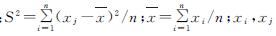
 ; n为地区总数; xi, xj为空间单元i,j的观测值; Wij为空间权重矩阵。采用其标准化统计量Z对Moran's I的显著性水平进行检验:
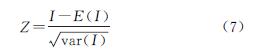
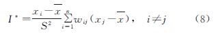
 为空间单元i,j的观测值; n为地区总数; Wij为空间权重矩阵。局部Moran's I指数的Moran散点图有4种空间关联模式:H—H型,即第一象限代表观测值高于平均值的区域被观测值高于均值的邻域包围; L—H型,即第二象限代表低于平均值区域被高于平均值的邻域包围; L—L型,即第三象限代表低于平均值区域被低于平均值邻域包围; H—L型,即第四象限代表高于平均值区域被低于均值的邻域包围。