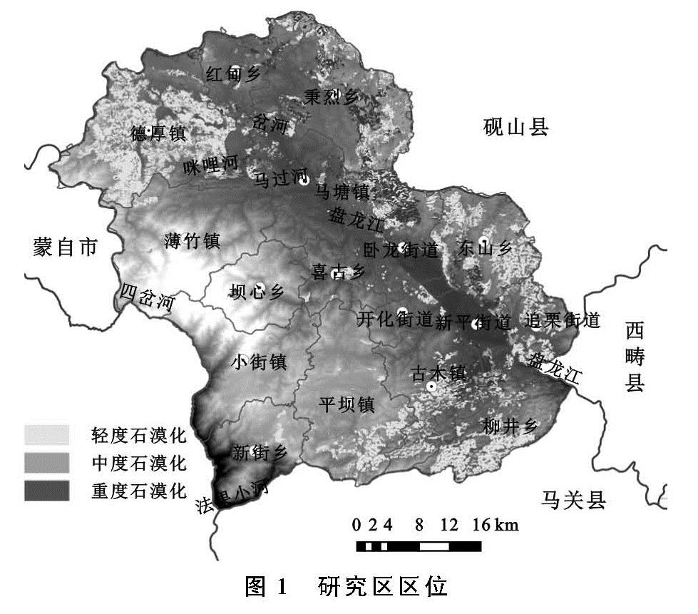
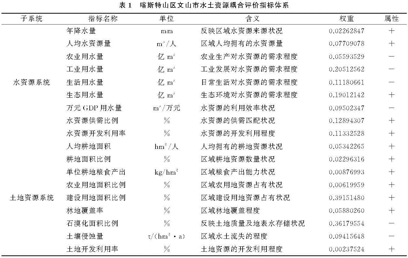
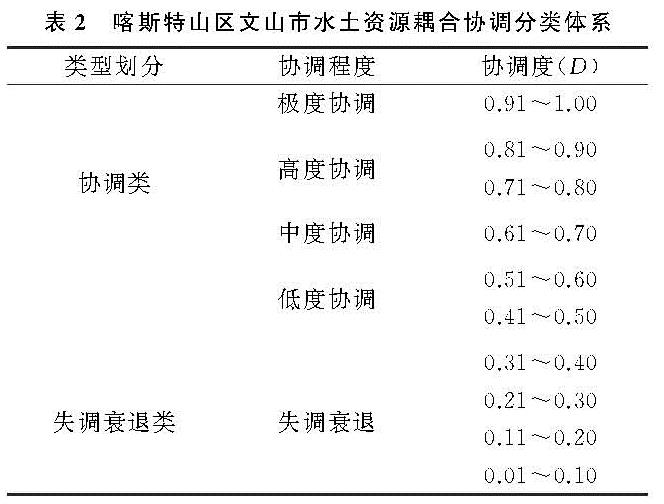
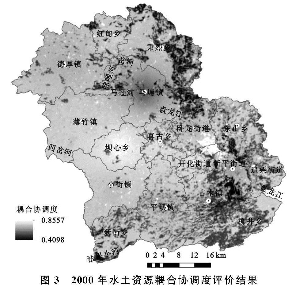
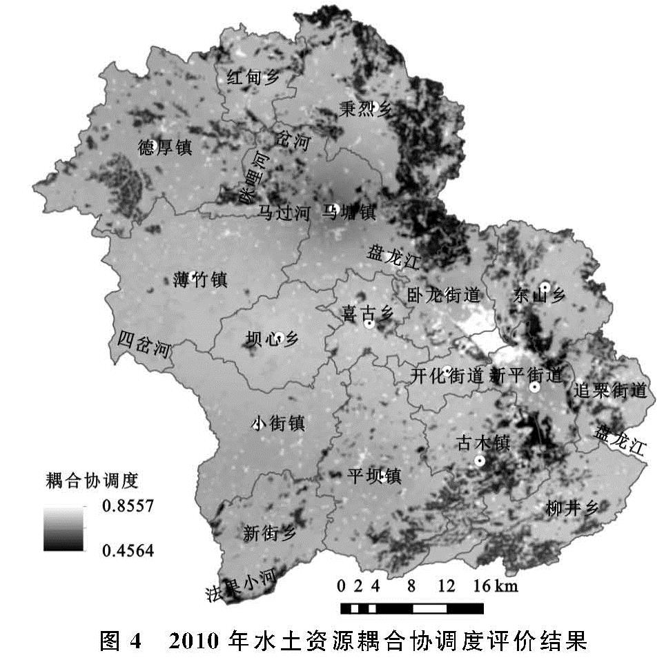
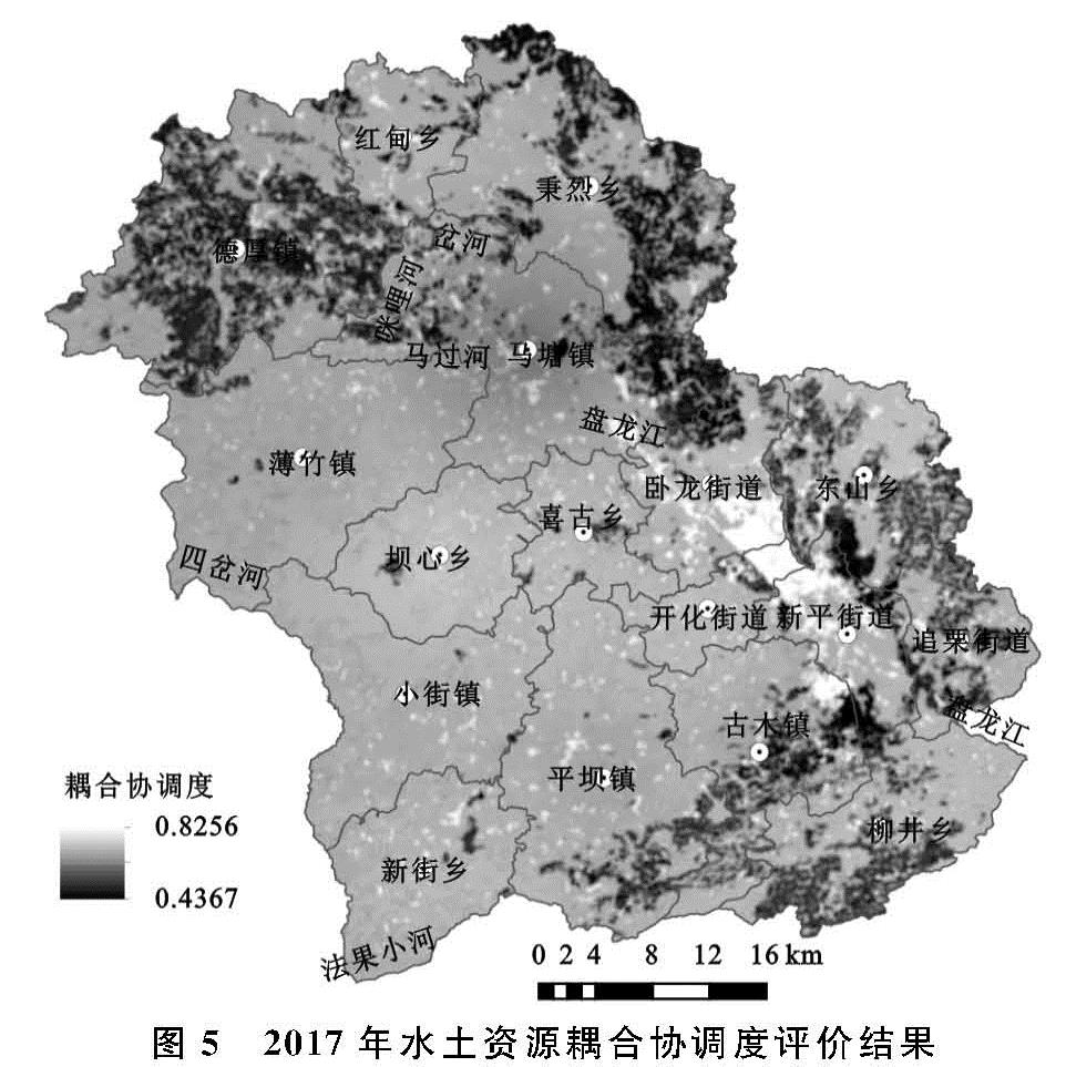
3.3.1 水土资源耦合协调度数量结构变化特征
文山市2000年水土资源耦合协调整体水平较高,水土资源耦合协调度为0.409 8~0.855 7,平均值为0.683 8,属于协调类,处于中度协调中上状态。从各耦合协调度等级面积比例来看,高度协调面积最大,为163 015.59 hm2,占土地总面积的54.98%,中度协调次之,面积为97 453.02 hm2,占全市总面积的32.87%,低度协调面积最小,为36 048.90 hm2,仅占12.16%(图3)。
文山市2010年水土资源耦合协调整体水平较高,水土资源耦合协调度为0.456 4~0.857 7,平均值为0.700 5,属于协调类,处于中度协调偏上状态,从各耦合协调度等级面积比例来看,高度协调面积最大,为210 938.07 hm2,占土地总面积的71.14%,中度协调次之,面积为60 754.98 hm2,占全市总面积的20.49%,低度协调面积最小,为24 824.46 hm2,仅占8.37%(图4)。
文山市2017年水土资源耦合协调整体水平较高,水土资源耦合协调度为0.436 7~0.825 6,平均值为0.683 8,属于协调类,处于中度协调中上状态。从各耦合协调度等级面积比例来看,高度协调面积最大,为168 815.97 hm2,占土地总面积的56.93%,中度协调次之,面积为90 334.44 hm2,占全市总面积的30.47%,低度协调面积最小,为37 367.10 hm2,仅占12.60%(图5)。
由此可见,2000—2017年喀斯特山区文山市水土资源耦合协调整体水平都较高,其中,2010年水土资源耦合协调水平最好,2000年、2017年水土资源耦合协调水平趋同,相比2010年耦合协调水平都较低,这主要是因为2010年石漠化面积比例比2000年、2017年都要低,石漠化区域地表水易漏失、水土流失严重,极易导致水土资源系统失衡,对水土资源耦合协调水平影响很大。2000年、2017年水土资源耦合协调度平均值都为0.683 8,2010年的耦合协调度平均值比2000年、2017年都高0.016 7。2010年高度协调面积比例比2000年、2017年分别高16.16%,14.21%,中度协调面积比例分别比2000年、2017年低12.38%,9.98%,低度协调面积比例分别比2000年、2017年低3.79%,4.23%。
3.3.2 水土资源耦合协调时空变化特征
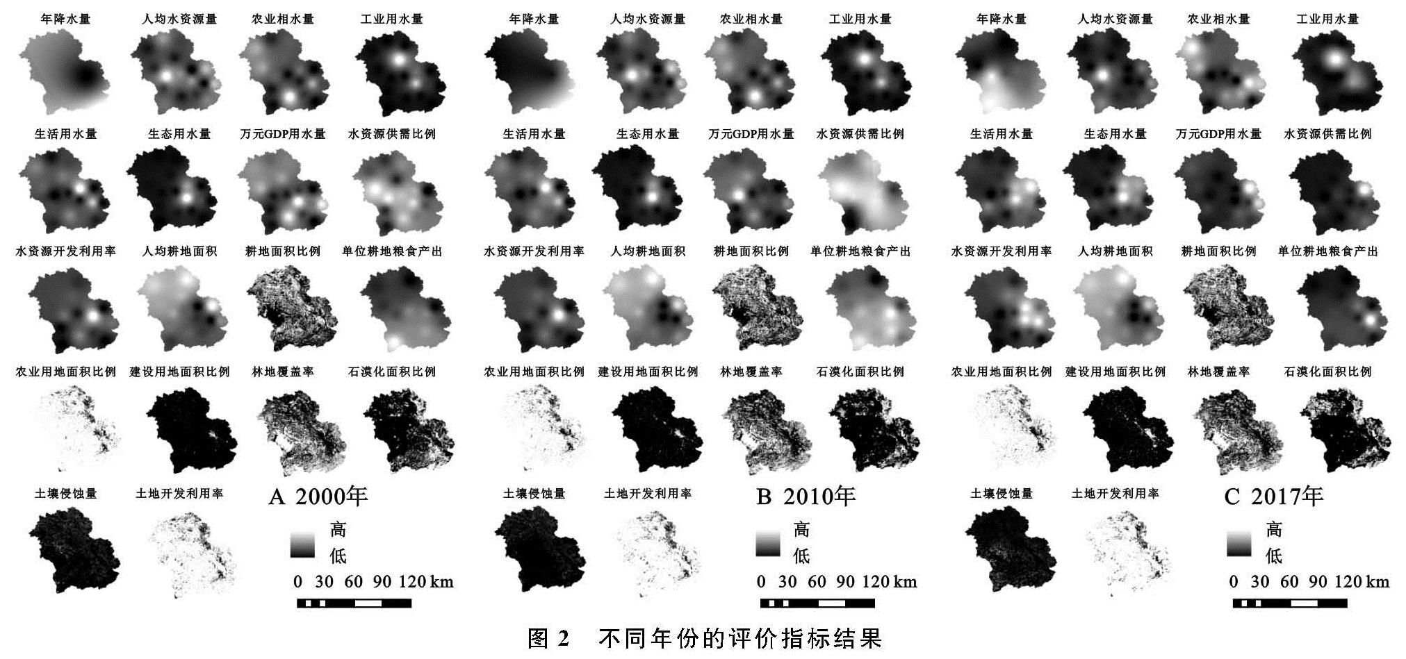
2000年市域东北部、东部和南部水土资源耦合协调性较差,尤其是东北部和东南部最为明显,西部水土资源耦合协调水平较高(图3); 2010年市域东部、北部和南部水土资源耦合协调性较差,东北部和东南部仍然为低协调面积分布最广的区域,西部和中部水土资源耦合协调水平较高(图4); 2017年市域西北部、东北部、东部和东南部水土资源耦合协调性较差,西部、西南部和中部水土资源耦合协调水平较高(图5)。可以看出,2000—2017年喀斯特山区文山市东北部、东部和东南部水土资源耦合协调性一直都较差,西部和中部耦合协调水平较高,其中,文山市市区水土资源耦合协调水平一直都较高。2000—2010年东北部、东部和东南部水土资源耦合协调度都较低,但2010年相比2000年西北部水土资源耦合协调性变差,西南部耦合协调水平提高,市区水土资源耦合协调度最高; 2010—2017年西北部大面积区域水土资源耦合协调性变差,西南部耦合协调水平继续得到提高,市区水土资源耦合协调度仍然最高; 2000—2017年西北部和西南部水土资源耦合协调水平变化最明显,其耦合协调度分别降低和提高,这与石漠化面积比例空间分布变化直接相关,2000—2017年西北部石漠化面积增加,而西南部石漠化面积减少(图3—5)。
3.3.3 水土资源耦合协调水平空间差异因素
文山市市区水土资源耦合协调水平一直都较好,主要是因为作为区域社会经济发展的中心,这里坝区面积大,无石漠化,土壤侵蚀量少,基础设施和水利设施完善,水资源开发利用率较高,水资源调配能力和供给保障能力较强,水土资源条件良好,有利于水土资源系统的协调与平衡; 市域水土资源耦合协调度较高的区域基本上无石漠化,年降水量多,林地覆盖率较高,植被生态系统涵养水源、水土保持和调节水土资源的能力较强,另外,区域耕地面积分布也较大,耕地的水土资源条件一般都较好,所以整体水土耦合协调水平较高; 水土资源耦合协调性较差区域大部分位于石漠化较严重处,土地资源质量低,坡度大,加之喀斯特地貌地表水渗漏严重,保水能力非常差,水土资源匹配水平低,应通过退耕还林、退耕还草和坡耕地改造等生态修复工程措施,加大对石漠化的治理力度,改善水土资源条件,提高水土资源开发利用率,促进水土资源耦合协调程度的提升。同时,水土资源耦合协调度呈现出和土地石漠化空间分布一致的规律,无石漠化区域水土资源耦合协调度处于高度协调状态,有石漠化的区域为中度协调和低度协调状态,且石漠化程度越高,耦合协调度越低,说明土地石漠化对水土资源耦合协调度产生较大影响。总之,要想提高文山市整体的水土资源耦合协调水平和社会经济发展水平,必须加强生态环境治理和保护,并提出符合喀斯特山区文山市实际的发展模式,促进产业发展和升级改造,提高水土资源利用效率。