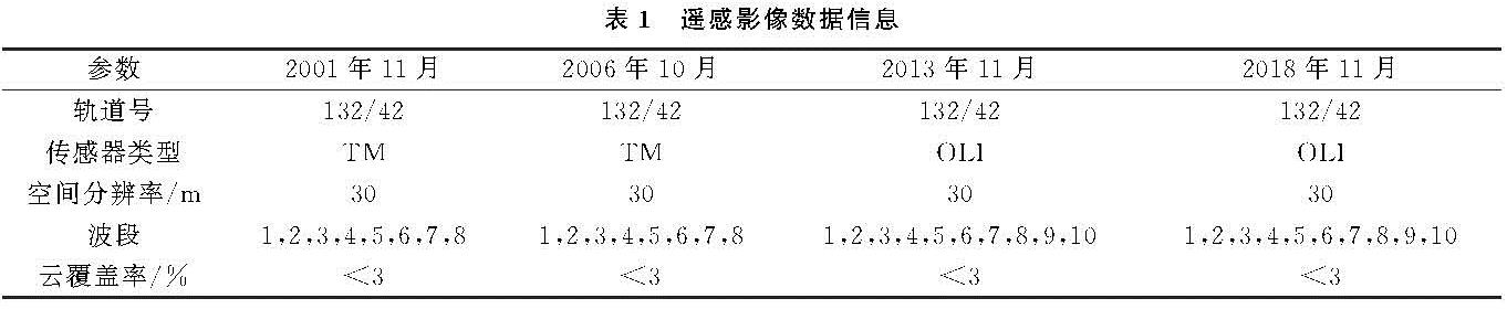
3.1 泸水市生态环境质量评价分析
3.1.1 生态环境质量时间变化分析
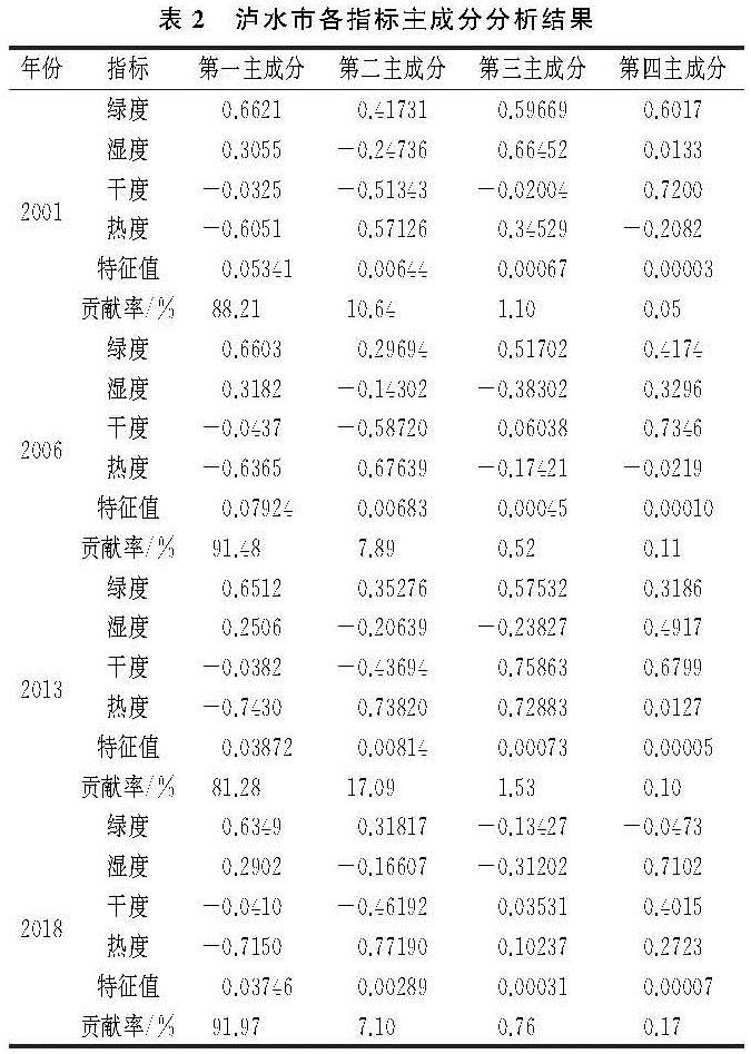
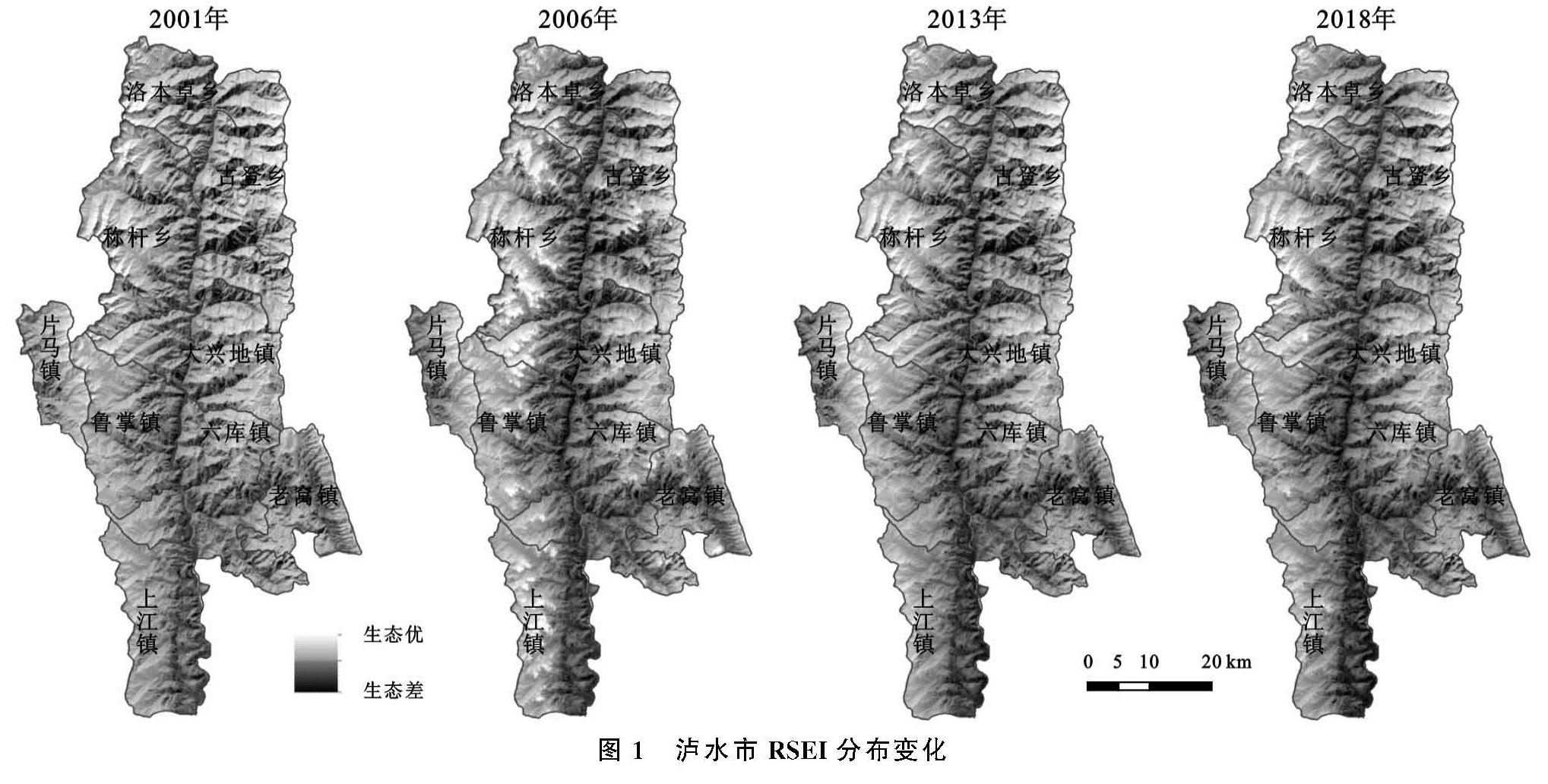
泸水市遥感生态指数计算结果表明(表2—3,图1),4个年份RSEI均值分别为0.750,0.759,0.667,0.683,整体表现为波动下降特征,在2001—2006年与2013—2018年两个时期有小幅上升。以上结果表明2001—2018年泸水市生态环境质量总体呈现波动变差的趋势。
从4个指标的均值和载荷值来看,绿度、湿度对生态环境变好起着正向作用,而干度、热度相反。泸水市绿度指标在2001—2018年持续下降,湿度、干度、热度在研究期内不断波动,没有明显的变化趋势,但在2001—2006年和2013—2018年两个时段,湿度有明显的增加,绿度减少有限,而干度和热度有所下降,所以这两个时段的生态环境质量有所改善。
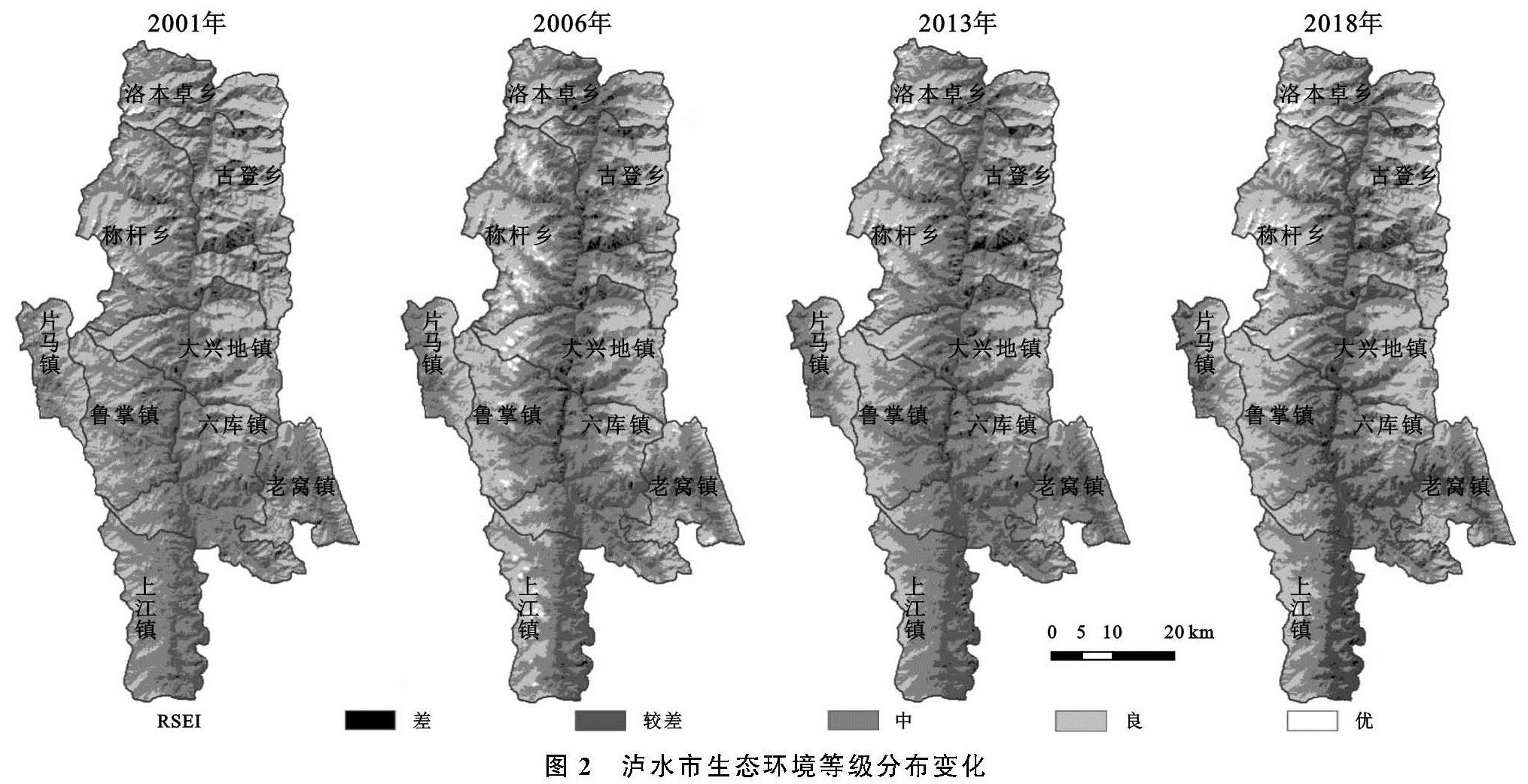
为更好地分析RSEI的分布情况,参考《生态环境状况评价技术规范》,将研究区的RSEI划分为差、较差、中等、良、优这5个等级,分别对应RSEI的范围为[0,0.2),[0.2,0.4),[0.4,0.6),[0.6,0.8),[0.8,1.0],并制作生态环境等级分布变化图和面积与比例统计表(图2,表4),直观显示4个时相中RSEI各等级变化情况。
从表4可以看出,泸水市生态环境质量由“较差”、“中”、“良”等级主导,3个等级占比之和达97%以上。RSEI中等及以下等级所占比例之和在2001年、2006年、2013年、2018年分别为66.20%,66.49%,72.67%,67.23%,呈波动上升趋势; 良及以上等级所占比例2001年、2006年、2013年、2018年分别为33.80%,33.51%,27.33%,32.77%,在2001—2013年逐渐下降,2013年以后有一定上升。RSEI各等级呈现这样的变化趋势也印证了2001—2018年期间泸水市的生态环境质量总体上在逐渐恶化,但在2001—2006年和2013—2018年两个时段又有所反弹好转的情况。
3.1.2 生态环境质量空间分布变化分析
如图2所示,总体来看,泸水市生态环境质量表现出明显的南北向狭长型分布特征。怒江作为纵向穿越泸水市的分界中线,其东西两岸的生态环境质量等级区域表现出较为明显的对称性,越靠近怒江,分布等级就越低,这与高山峡谷的地貌特征相吻合。
从各质量等级分布来看,差和较差等级主要聚集于怒江水系河谷两岸及周围缓坡地带,在怒江州府驻地的六库镇市区、古登乡佑雅村—腊斯底村一带、上江镇境内的小型坝区等区域有小范围集聚。这些地区人类活动密集,建设用地扩张迅速,是全市主要的城镇聚集地和耕地分布区域,而在称杆乡与古登乡境内则存在大片地表裸露、水土流失严重、生态环境恶劣的未利用地和低覆盖度草地,影响了区域整体的生态环境。2001年较差区域已基本覆盖全市怒江水系河谷地区,之后河谷地区生态环境质量的恶化面积与程度逐渐加深,至2018年更是辐射影响到周边一定范围。
生态环境质量等级中及以上的区域主要分布在泸水市境内碧罗雪山与高黎贡山一带的中高山地区。优等级区域多聚集在泸水市西北部称杆乡和洛本卓乡境内,这些区域以林地为主要地类,山高林密,居民点少,基本未受到人类活动侵扰。2001年以后,生态环境质量等级为良的区域有连片趋势,中等级区域变化不大,但也有不少靠近河谷的区域逐渐从中等级转为较差等级。
3.1.3 生态环境质量变化成因分析
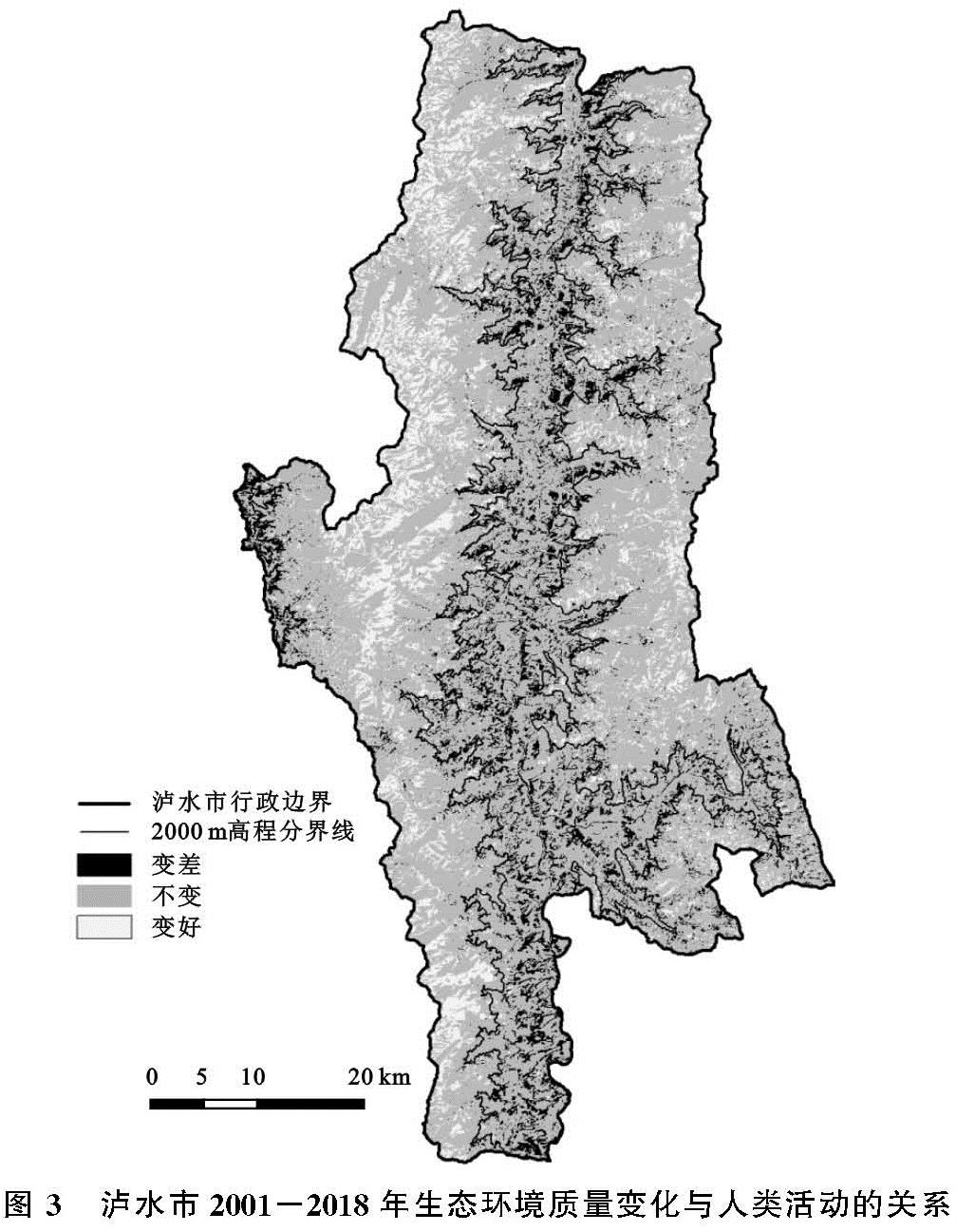
泸水市地处怒江流域核心地区之一,根据樊辉等[23]的研究,整个怒江流域在近几十年中,年均气温升高趋势显著、年均降水变化不显著,总体可能会对当地生态环境产生负面影响。生态环境质量变化除了与气候变化有关外,人为因素也会产生直接影响,进一步发掘泸水市生态环境质量变化的驱动原因,特别是与人类活动的关系。将泸水市2001年和2018年的生态环境质量等级分布图进行叠加,用前期的RSEI等级减去后期的RSEI等级,等级差值为负、0、正,依次代表生态环境变差、不变和变好,得到泸水市2001—2018年生态环境质量变化分布图。统计后,泸水市2001—2018年生态环境质量变差、不变、变好的比例分别为9.71%,77.12%,13.17%。
由于泸水市交通运输、工程建设、生活居住、农业耕作等人类活动主要集中在海拔2 000 m以下区域,因此,将泸水市分为人类活动区(海拔≤2 000 m)和自然生态区(海拔>2 000 m),分别统计两类区域中RSEI等级的分布和变化情况(表5)。最后再将生态环境质量变化分布图与2 000 m高程分界线叠加,得到图3,可以直观分析泸水市生态环境质量变化区域在人类活动区和自然生态区的分布情况。
图3 泸水市2001-2018年生态环境质量变化与人类活动的关系
根据表5可知,在泸水市人类活动区,RSEI差和较差等级的范围在2001—2012年呈扩大趋势,中和良等级则有明显缩小,到2018年虽有所反弹,但相比2001年,生态环境质量已有显著恶化; 在自然生态区内,RSEI差和较差等级的面积呈波动减少的趋势,良和优等级的面积为波动增加趋势,整体上在18 a中表现出生态环境质量变好的态势。再分析图3,泸水市生态环境质量变好的区域主要分布在怒江西部高黎贡山和东部碧罗雪山的中高山地区,纵贯泸水南北,这里是高黎贡山国家自然保护区的核心区域; 变差区域主要聚集在怒江水系河谷地带,较多分布在中部的鲁掌镇、大兴地镇和南部的六库镇和上江镇。再结合2 000 m高程分界线,可明显发现人类活动区与自然生态区的生态环境质量变化趋势截然不同。泸水市生态环境质量恶化的区域绝大部分位于人类活动区范围内,而生态环境质量改善的区域则主要分布在海拔2 000 m以上的自然生态区。
人类活动区和自然生态区呈现出不同的生态环境质量分布变化特征,说明泸水市在2001—2018年中生态环境质量的下降主要是受2 000 m以下人类活动区的生态环境质量恶化所致,而2 000 m以上地区受人类干扰减少,加上合理的保护,使这一区域的生态环境质量反而有一定提高。进入21世纪后,退耕还林、陡坡地生态治理等一系列生态恢复工程陆续在泸水市启动,经过近20 a的实施,2 000 m以上中高山地区的人类活动明显减少,陡坡耕地、草地、未利用地的植被逐渐恢复,森林覆盖率不断提升。但人类活动在2 000 m以上地区的退出,就不得不向着低海拔地区逐渐聚集,加上经济社会各方面建设的快速推进,加剧了2 000 m以下河谷和低山地区生态环境的恶化。特别1 500 m以下的河谷生态恶化区以5.57%的国土面积集中分布了泸水市近70%的人口,加上不合理的土地利用方式,已成为全市生态环境最恶劣的地区。以上分析在一定程度上说明了生态环境质量对人类活动反应的敏感性,人类对环境的快速改造会对生态环境产生显著的负面影响。
3.2 泸水市生态环境质量变化与退耕还林工程的关系分析
云南省是实施退耕还林工程的重要省份[24],选取泸水市在2002年和2014年分别实施了两轮退耕还林工程,对当地地表环境产生着直接影响,是研究期内生态环境质量变化的重要影响因素之一。为了科学评估泸水市退耕还林工程实施效果,揭示退耕还林工程与生态环境质量变化的关系,首先统计分析耕地在坡度梯度的面积变化情况,评价泸水市2001—2018年退耕还林工程的效果; 再进一步计算2001—2006年和2013—2018年两个退耕还林实施期中各乡镇退耕还林率,分乡镇与对应RSEI变化值进行拟合,评价泸水市生态环境质量变化与退耕还林工程的相关性大小。
3.2.1 退耕还林工程实施效果
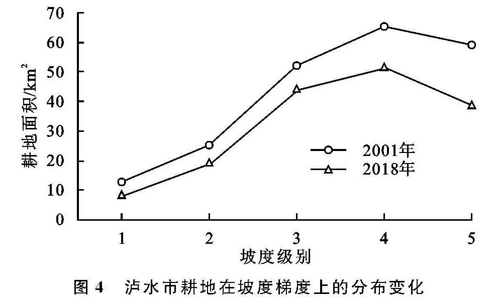
根据退耕还林工程主要针对25°以上的坡耕地这一特点,分析泸水市退耕还林工程坡度分布及变化特征,以评价退耕还林工程的实施效果。考虑到高山峡谷地区坡度陡,低坡度地区面积极小的地形特征,参考相关论文[25],将坡度分为五级:1级(0°~8°),2级(8°~15°),3级(15°~25°),4级(25°~35°),5级(>35°),分别统计2001—2018年各级耕地面积变化情况(图4)。
从图4可以看出,在小于35°的坡度区间,泸水市耕地面积随坡度等级的升高而逐渐增加,大于35°后又有所降低。坡度大于25°的耕地占到耕地总面积的55%以上,坡度小于8°的耕地只占到5%左右。以上统计说明泸水市陡坡耕种现象十分普遍,低质量的坡耕地成为全市主要的耕地资源。大量陡坡地区被开垦为耕地后,植被覆盖度降低,会导致水土流失加重、地质灾害易发,严重威胁着当地的生态环境。对比2001年和2018年耕地在坡度梯度上的分布变化,不难发现各坡度等级的耕地面积均有不同程度的下降,特别是坡度大于25°的耕地面积减少尤为明显,占总减少面积的64.74%。而在所有减少的耕地中有75.49%转变为林地,说明泸水市的耕地在18 a中发生这样的变化与退耕还林工程密不可分。以上统计都证明了泸水市退耕还林工程的效果显著,基本达到了工程实施的预期目标。得到退耕还林的耕地在转为林地和草地后,会对局部地区乃至怒江州的生态环境质量产生积极影响。
3.2.2 生态环境质量变化与退耕还林面积的相关性
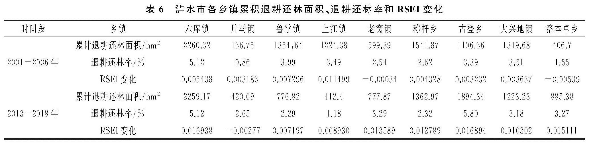
对2001—2006年和2013—2018年两个时段的泸水市各乡镇累计退耕还林面积进行统计,然后依据公式(13),求出每期各乡镇退耕还林率(表6)。
S=(N/K)×100% (13)
式中:S是某期该乡镇退耕还林率; N为某期该乡镇退耕还林面积; K是该乡镇土地总面积。
表6 泸水市各乡镇累积退耕还林面积、退耕还林率和RSEI变化
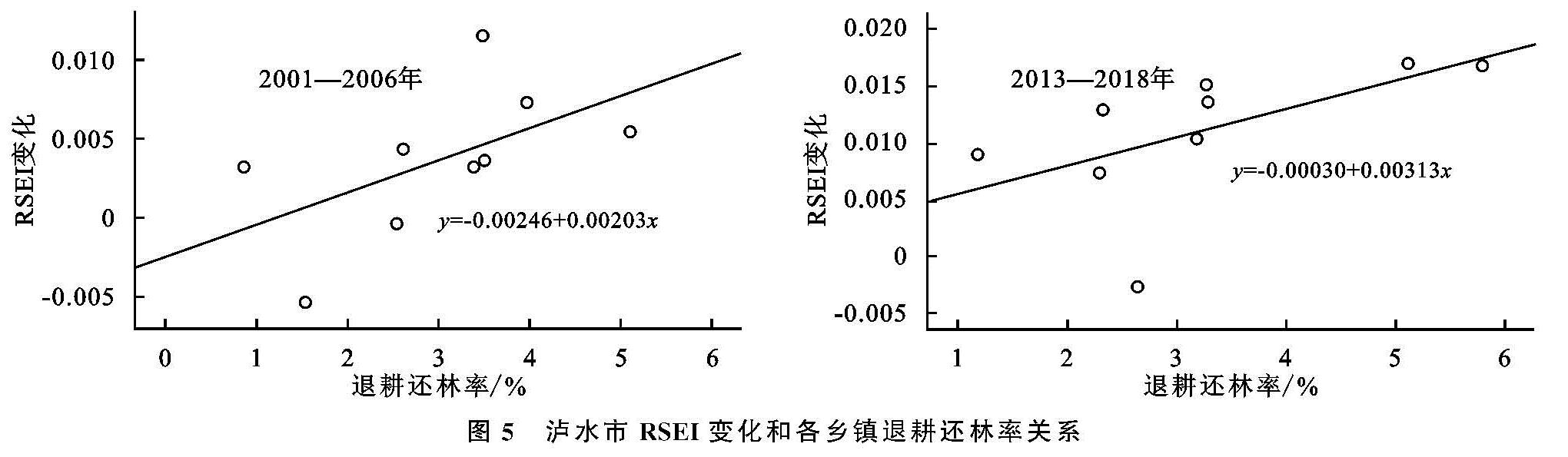
分别将各乡镇统计结果序列与对应区域的RSEI期内差值在SPSS 26统计软件中进行斯皮尔曼相关性分析,结果见图5。2001—2006年,退耕还林率与遥感生态指数RSEI变化在0.05级别显著性水平下,相关系数为0.767,为强相关; 2013—2018年,退耕还林率与遥感生态指数RSEI变化在0.01级别显著性水平下,相关系数为0.817,为强相关。可见,泸水市退耕还林率与生态环境质量变化的相关性较高,也说明退耕还林工程对实施地区的生态环境质量有着积极影响。
4 结论与讨论
(1)从时间变化上看,泸水市2001年、2006年、2013年、2018年RSEI均值分别为0.750,0.759,0.667,0.683,总体呈小幅波动下降趋势。生态环境质量良及以上等级所占比例分别为33.80%,33.51%,27.33%,32.77%。泸水市2001—2018年期间的生态环境质量总体上逐渐恶化,但在2001—2006年和2013—2018年两个时间区间又有所反弹好转。
(2)从空间分布上看,泸水市生态环境质量呈现明显的南北向狭长型分布特征,且怒江东西两岸的生态环境质量等级区域表现出一定的对称性,这与其高山峡谷的地貌特征吻合。分析生态环境质量变化成因后发现,泸水市总体生态环境质量的恶化除了与怒江流域气候的变化有一定关系外,更与2 000 m以下区域人类活动的活跃和干扰密切相关,说明了生态环境质量对人类活动反应的敏感性。
(3)退耕还林工程的实施,对工程实施期内泸水市的生态环境产生着积极影响。统计分析发现,泸水市退耕还林工程效果显著,大量坡耕地得到退耕。在2001—2006年和2013—2018年两轮退耕还林工程主要实施期内的相关性分析中,生态环境质量变化也与退耕还林工程有较高的相关性。
进入21世纪后,泸水市响应国家发展战略方针,重点开展了退耕还林工程,并配合天然林保护、陡坡地生态治理、自然保护区建设、林业改造等其他生态恢复工程,主要修复了怒江流域生态脆弱区、生态重要区的生态环境。各项生态恢复工程互为配合、多头并进,有助于调节气候环境、增加植被覆盖度、优化利用林业资源、遏制水土流失和自然灾害,提升生态系统稳定性和生态服务功能,促进形成有效的国土生态安全体系。
但是从本研究的生态环境质量变化分析不难发现,泸水市退耕还林工程及其他生态恢复工程对生态环境的恢复效果依然有限,绿度等指标在18 a中依然呈小幅下降趋势,且2 000 m以下人类活动活跃地区的生态环境变化形势也不容乐观。今后应扩大生态环境保护的范围,并加大投入,将保护工作的重心向2 000 m以下人类活跃地区倾斜,制定出针对性的生态修复方案。同时,也应及时调整经济社会发展方式,保护与减少破坏并行,通过优化资源利用模式,降低对生态环境的破坏。
由于在数据、技术等方面的限制,本研究会存在一些不足之处,如遥感影像时相无法完全一致、影像分辨率不高、影像中山体光照阴影的存在等问题都会对RSEI结果产生影响。此外,虽然对生态环境质量变化的成因进行了一定分析,但对气候、人类活动等因素的驱动内因未有深入的探讨,因此也将进一步加深这方面的研究。