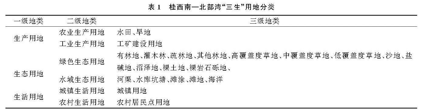
3.1 “三生”用地水平变化特征
对比分析1980—2018年桂西南—北部湾地区“三生”用地面积变化和运用土地利用动态度计算各类用地的变化速度(表3),38 a“三生”用地变化中,只有生态用地减少,面积由70 001 km2减少到69 217 km2,共减少了784 km2,年动态度为-0.029 5%; 生活用地显著增加,面积由1 684 km2增加至2 426 km2,增加了742 km2,年动态度为1.159 5%; 生产用地相对稳定,面积仅增加了42 km2,年动态度为0.004 6%。“三生”用地二级分类中,工业生产用地和城镇生活用地扩张速度最为明显,面积分别扩张了609 km2,581 km2,年动态度分别为13.136 3%,9.155 4%,其他二级分类用地变化较小,其中农业生产用地和绿色生态用地均呈现负增长态势,面积分别缩减了567,840 km2,年动态度分别为-0.062 9%,-0.032 4%。
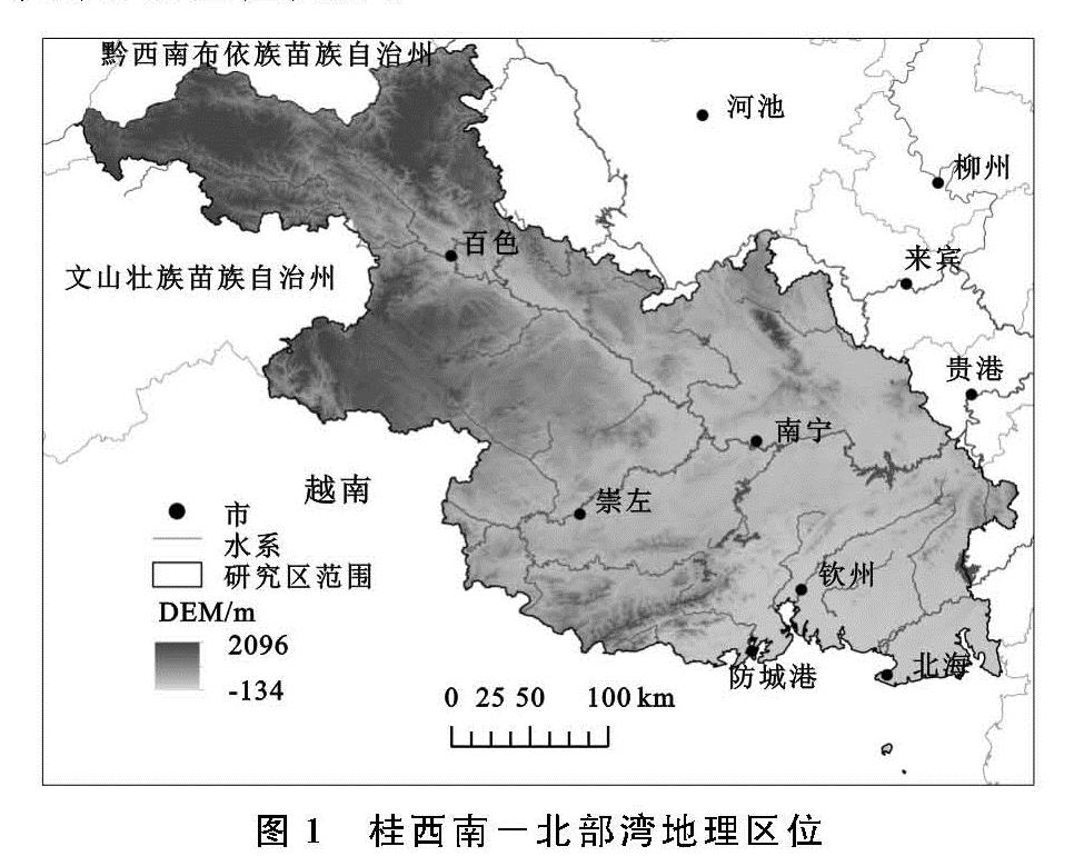
1980—2018年桂西南-北部湾地区“三生”用地分布如图2所示,生态用地集中分布在百色、崇左和防城港市,其中百色和崇左市位于桂西南的喀斯特山区,石漠化较为严重,不利于发展生产生活,防城港市依托十万大山优势拥有丰富的生态资源。生产用地主要分布在北部湾地区的南宁市和北海市,钦州市的生产用地相对分散。生活用地主要聚集在城镇中心,在广大农村偏远地区零散分布,尤其是百色市西北部的生活用地极为稀少,而位于首府南宁市的城市中心和北海市沿海地区的生活用地数量较多且集中发展。在38 a间,以南宁和北海市区为代表的生活空间逐年扩大,各市区的生活空间也在缓慢增长,其中城镇生活用地扩张速度最快。生产用地的数量虽然没有太大变化,但是在二级地类中,工业生产用地增加明显,农业生产用地减少。
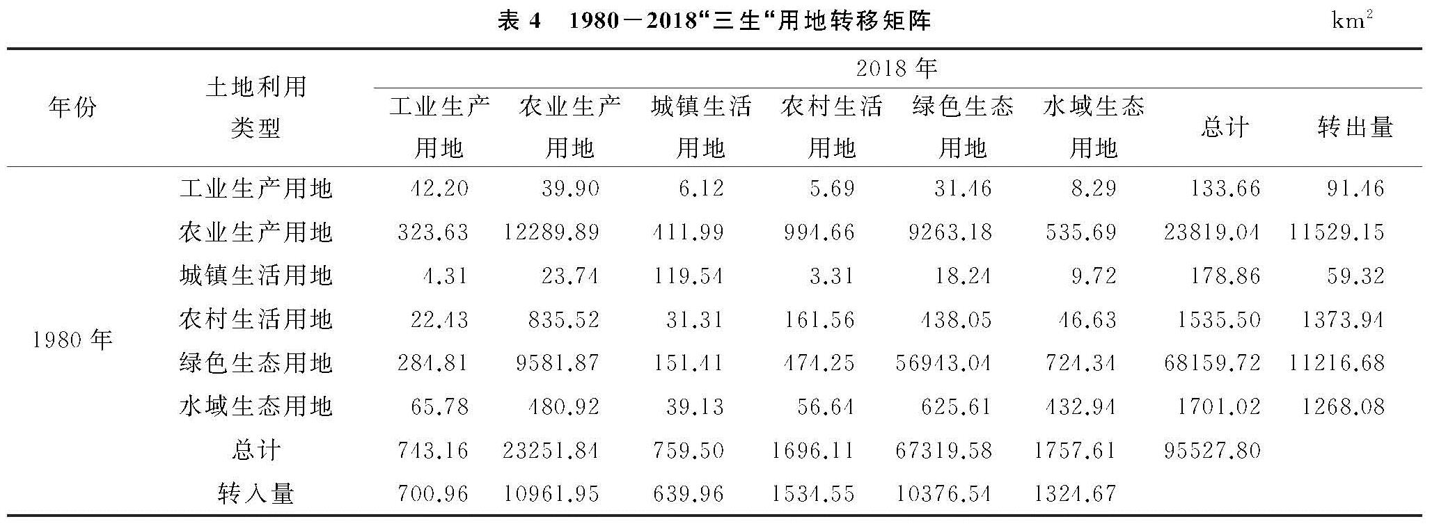
基于桂西南—北部湾“三生”用地分布图层,经ArcGIS提取得到研究区1980—2018年“三生”用地转移矩阵(表4),发生变化面积25 538.63 km2,占土地总面积的26.73%。从“三生”用地转型的方向可以得出:1980—2018年期间不同用地类型的转出面积大小依次为农业生产用地>绿色生态用地>农村生活用地>水域生态用地>工业生产用地>城镇生活用地。农业生产用地和绿色生态用地的转出量达到了上万平方千米,农业生产用地主要流出方向为绿色生态用地,而绿色生态用地的主要流出方向是农业生产用地,通过对比分析发现,分布零散、位置偏远和远离居民点的农业生产用地转变为了生态用地,而原处于生活用地与生产用地之间的绿色生态用地则转变为了农业生产用地,农业生产用地更聚集化发展。同时,工业生产用地、城镇生活用地和农村生活用地流出面积最大的方向均为农业生产用地,虽然农业生产用地的流入面积最多,但是其流出面积大于流入面积,总体上农业生产用地面积缩减,可以看出农业生产用地变化幅度较大,与各地类之间的转换更为频繁。
图2 1980-2018年桂西南—北部湾“三生”用地类型分布
表4 1980-2018“三生“用地转移矩阵km2
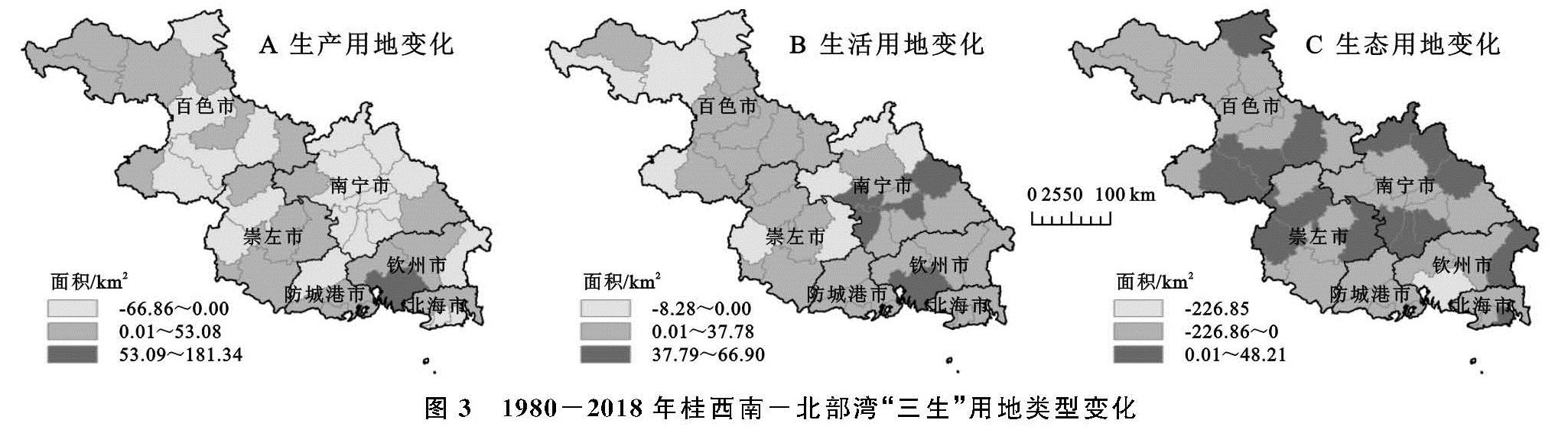
桂西南—北部湾地区1980—2018年期间,“三生”用地变化空间分布见图3。生产用地面积减少的区域主要分布在喀斯特山区百色市,经济较发达地区南宁市和沿海旅游城市北海市,百色市生产用地减少的县域及县级市包括乐业县、右江区、德保县、田东县和靖西市,北海市包括海城区、银海区和铁山港区3个重要沿海区域,南宁市除隆安县和横县之外的10个县区生产用地面积均出现了下降。生产用地面积增加最为明显的是钦州市钦南区,主要增加的二级地类为农业生产用地。生活用地面积减少的区域除崇左市的龙州县外,其余均位于百色市和南宁市,其中百色市包括西林县、田林县、乐业县和那坡县,南宁市包括马山县、上林县、隆安县,生活用地面积增加较为明显的是南宁市的西乡塘区、江南区、青秀区和宾阳县,以及钦州市的钦南区。生态用地面积减少的地区较多,其中钦州市钦南区减少的最为明显,生态面积增加的地区主要以百色市、南宁市和崇左市为主,其中百色市包括乐业县、田东县、德保县和靖西市,南宁市包括马山县、上林县、宾阳县、邕宁区、良庆区、江南区,崇左市包括扶绥县、大新县和龙州县。
3.2 “三生”用地垂直变化特征
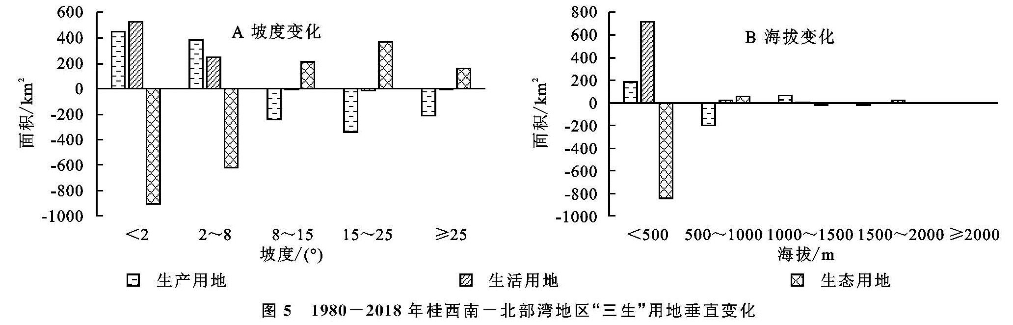
由图4可知,2018年桂西南—北部湾地区的“三生”用地垂直分布现状中,生产用地和生活用地面积呈阶梯式下降,随着坡度和海拔的增长而减少,生产用地和生活用地集中主要分布在0°~8°的坡度平缓地区以及海拔低于500 m的地区。在坡度分布中,生态用地面积呈倒U型分布状态,在<2°和≥25°的坡度范围内面积较少,集中分布在2°~25°。在海拔分布中,生态用地面积随着海拔的升高而减少,其中<500 m海拔的地区中生态用地最多,在≥2 000 m的海拔中,无生产用地和生活用地,仅有少量的生态用地。由图5可知,1980—2018年桂西南—北部湾地区“三生”用地变化中,在0°~8°坡度区间生态用地面积大幅度减少,生产生活用地面积大量增加,≥8°坡度范围内生态用地面积增加,生产及生活用地面积减少。在海拔变化中,海拔<500 m的区域生态用地大量减少,生产生活用地增加,其中生活用地增加幅度较大。海拔500~1 000 m区间仅有生产用地减少,且减少幅度较为明显,海拔≥1 000 m的区域内地类变化较少。
图3 1980-2018年桂西南-北部湾“三生”用地类型变化
图4 2018年桂西南-北部湾地区“三生”用地垂直分布
图5 1980-2018年桂西南-北部湾地区“三生”用地垂直变化
3.3 基于地理探测器的因子探测分析
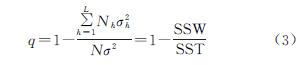
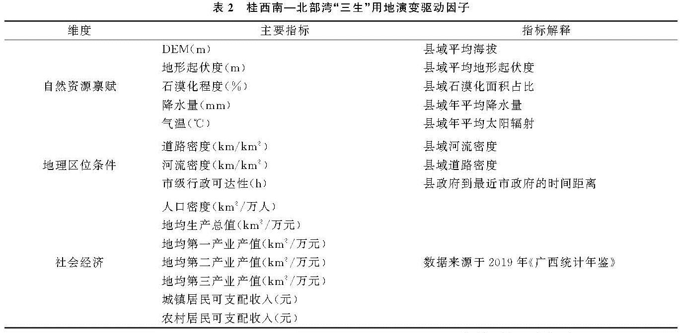
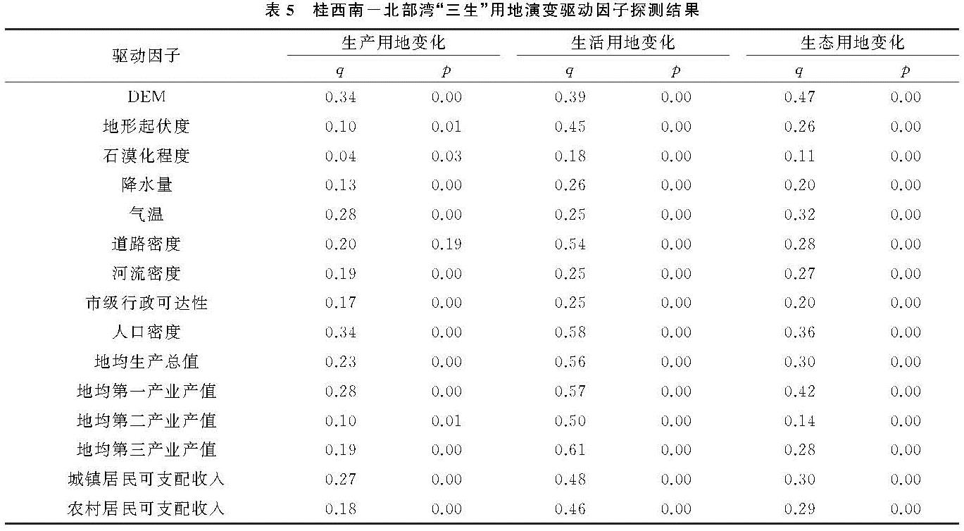
“三生”用地变化是自然、地理区位和社会经济因子复杂耦合作用过程在空间上的表现,利用地理探测器方法可分析各驱动因子在多大程度上解释“三生”用地变化的空间分异现象。将生产、生活和生态用地在1980—2018年面积变化作为因变量,从自然资源禀赋、地理区位条件和社会经济3个方面选取15个自变量。在ArcGIS软件中根据各驱动因子的聚集特征进行分级,实现离散化,运用地理探测器软件对生产用地变化、生活用地变化和生态用地变化3个因变量和16个自变量分别进行因子探测(表5),求得各因子对“三生”用地变化的影响力值(q值,其值越大表明该因子对“三生”用地变化的影响越大,反之亦然)和因子解释力值(p值,其值越小表明该因子对“三生”用地变化影响的解释力越大,反之亦然),分析结果显示,对生产和生态用地变化解释力最强的因子均是DEM,对生活用地变化解释力最强的因子是地均第三产业产值(0.61),石漠化程度对生产、生活和生态用地变化的驱动力最小。对生产用地变化影响较大的因子主要有DEM(0.34)、人口密度(0.34)、气温(0.28)、第一产值(0.28)、城镇居民可支配收入(0.27)等; 对生活用地变化影响较大的因子主要有第三产值(0.61)、人口密度(0.58)、第一产值(0.57)、生产总值(0.56)和道路密度(0.54)等; 对生态用地变化影响较大的因子主要包括DEM(0.47)、第一产值(0.42)、人口密度(0.36)和气温(0.32)等。
表5 桂西南-北部湾“三生”用地演变驱动因子探测结果