3.1.1 不同林分密度刺槐林地土壤水分随土层深度的变化
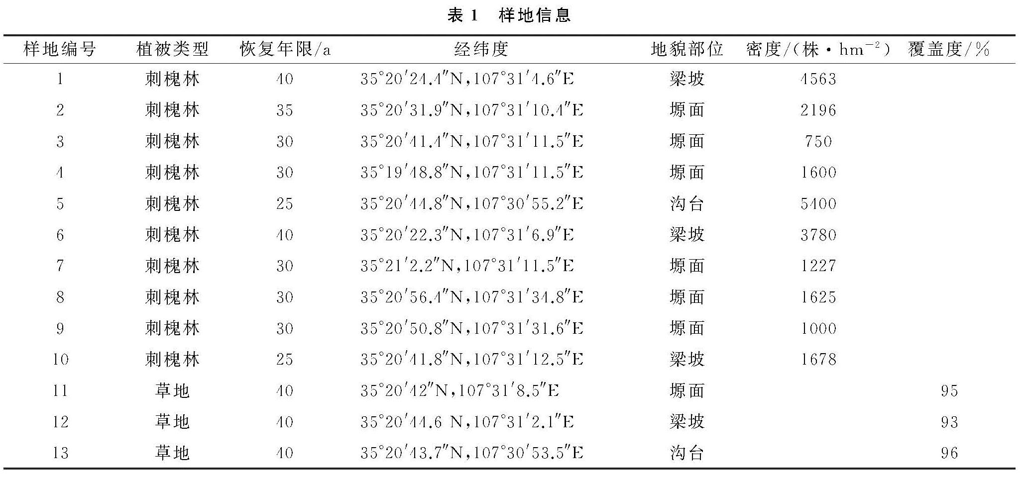
从土壤平均含水量在土壤垂直剖面上的变化曲线(图1)可以看出,高、中、低3个密度等级的人工刺槐林地土壤水分的变化趋势基本一致,均为在近地表(0—60 cm)随土层深度增加而减少(其中在0—40 cm土层范围内是迅速减少,40—60 cm减少的幅度有所放缓),60 cm处出现拐点之后,3个密度林地的土壤含水量随深度的变化趋于缓和(中密度林地几乎不变,而低密度和高密度略有增加); 同时在近地表(0—60 cm)中、低密度刺槐林土壤水分差异最小,但明显高于高密度刺槐林,大约高出3.50%; 土壤含水量最大值出现在近地表0—15 cm的中密度林地(20.76%)。
图1 不同林分密度刺槐林地土壤含水量随土层深度的变化
3.1.2 不同林分密度土壤水分含量季节性变化
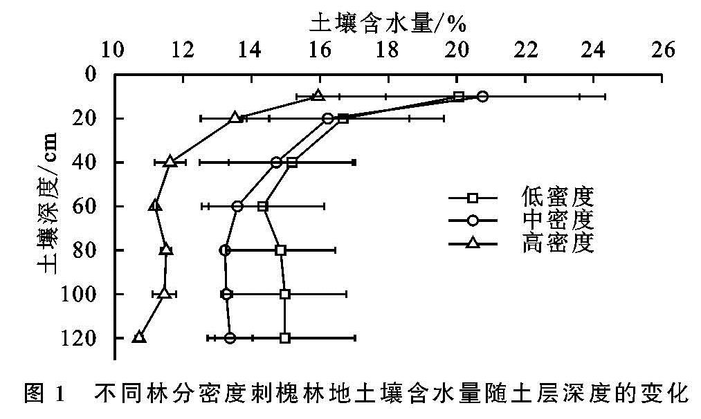
由图2可以看出,随着时间的变化,高、中、低林分密度土壤水分含量变化趋势基本一致,呈现出几乎对称的变化状态(4—6月缓慢下降,6—7月快速上升,7—8月迅速下降,8—10月缓慢上升),且6—8月变化幅度大,而4—6月和8—10月变化较为和缓; 3个密度等级中高密度林地土壤水分含量的变化幅度最大(7.31%),并在8月份后仍然在缓慢下降(其他2个密度的林地这一时期土壤水分含量是略有所上升的); 低、中密度林地的土壤水分含量在7—8月非常接近。详细分析中密度等级的人工刺槐林土壤水分含量随着时间的变化还可以看出:中密度刺槐林地在生长季(4—6月)土壤含水量的下降幅度高于低密度与高密度。
图2 不同林分密度刺槐林地土壤水分含量随时间的变化
3.2 草地和林地的土壤水分垂直分布差异
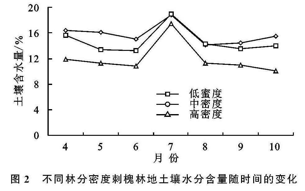
考虑到地表形态对土壤水分的影响,研究分别选取了塬面、梁坡与沟谷3种地形部位的刺槐林地与草地进行比较。
3.2.1 塬面林地和草地土壤含水量随土壤剖面深度的变化
由图3A可以看出,塬面林草地土壤含水量随土层深度的变化趋势非常相似,均为随着土层深度的增加而减小; 但林地土壤含水量明显要大于草地,其变化幅度也大,在0—40 cm范围内呈现锐减状态,40 cm处出现拐点,从大于20%一直下降到13%左右,减少了近8%,之后略有增加便基本保持稳定; 而草地土壤水分含量远远低于林地,大约低10.57%,在0—10 cm的浅表层土壤含水量大于6%,80 cm处最低,在3%左右,并草地土壤含水量随土层深度的变化幅度明显小于林地,在0—40 cm范围内是缓慢减少的,之后变幅更小。
3.2.2 梁坡林地和草地土壤含水量随土壤剖面深度的变化
从图3B可以看出,梁坡上林地与草地土壤含水量的变化在表层是相反的; 在0—40 cm范围内林地土壤水分含量一直在下降达,到40 cm下降到最低点; 而草地0—40 cm范围内是随着土层深度的增加而逐渐增加的; 40 cm以下林地与草地土壤含水量的变化都趋于和缓; 梁坡林地和草地深层土壤水分的含量是最为接近的。
3.2.3 沟台林地和草地土壤含水量随土壤剖面深度的变化
由图3C可得,沟台地林草在0—20 cm深度范围内变化趋势一致,均随着土层深度的增加而下降; 但林地是一直下降,直到60 cm埋深处才降到最低点,而草地在20 cm左右转为升高,即林地与草地土壤水分随着土层深度的增加逐渐下降的态势只是在表层,20 cm以下随着土层深度的增加,林草的变化趋势相反,在20—60 cm范围内,草地是逐渐增加的,而林地是继续下降; 60 cm以下随着土层深度的增加林地与草地土壤水分变化不再明显; 沟台地林地土壤水分随着土层深度变化的总趋势最明显,基本上一直为减少状态。
图3 不同地形沟台林地和草地月平均含水量随土层深度的变化
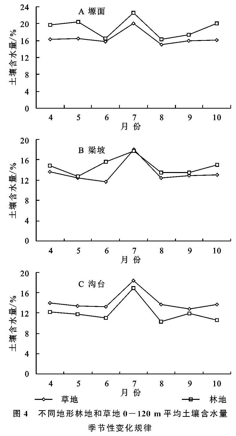
3.3 林地和草地土壤水分的季节变化特征
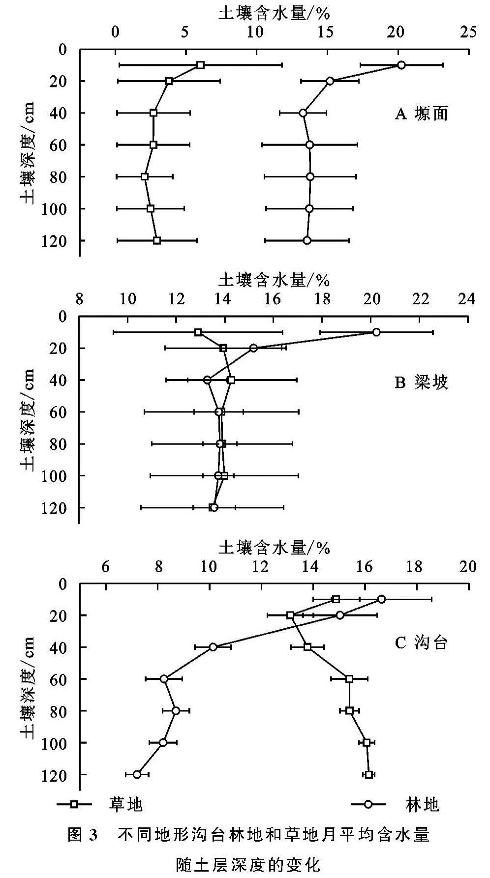
由图4可知,林地和草地土壤含水量具有明显的季节变化规律,变化趋势基本一致,从4月到10月整个生长季内大致表现为:缓降—急升—速降—缓升,整个地貌部位大体呈现出同一规律的动态变化(4—6月土壤水分含量缓慢降低,6—7月土壤水分含量直线迅速上升,7—8月土壤水分含量迅速下降,9—10月份土壤含水量缓慢下降),6—8月有较大变幅,7月份达到最大值并在不同地貌部位,土壤水分含量多为林地高于草地。
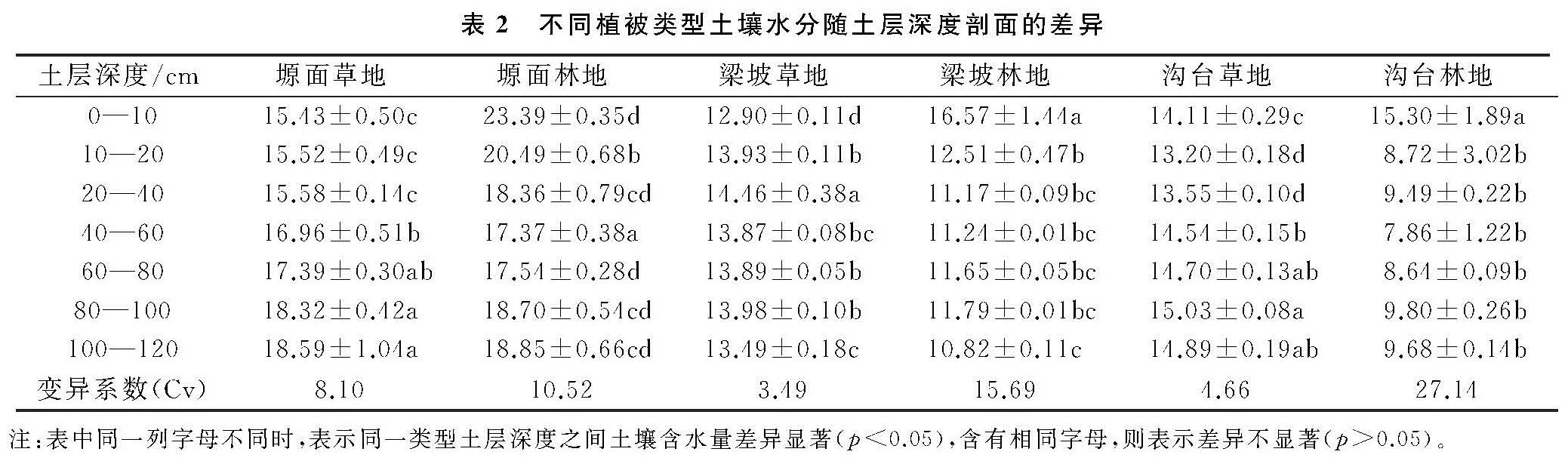
3.4 不同植被类型土壤水分随土层深度剖面的差异性
分析表2可知,不同地貌部位林地的变异系数均大于草地。综合分析表明:在0—60 cm范围内随着土层深度的增加,在不同地形部位(塬面、梁坡和沟台),林地的土壤含水量均呈现下降趋势,而草地变化没有林地明显。对0—20 cm土壤平均含水量进行分析显示:塬面林地土壤含水量比草地土壤高,沟台的差异较小,梁坡差异较大; 在40—120 cm土层深度范围,塬面林地土壤含水量远远大于草地的土壤含水量,梁坡林地和草地的土壤含水量非常接近,沟台草地土壤含水量远高于沟台林地。不同密度人工刺槐林土壤含水量在不同埋深多表现为:低密度林分>中密度林分>高密度林分,但近地表(0—60 cm)中、低密度刺槐林土壤水分差异很小,并明显高于高密度刺槐林; 同时生长季开始高、中、低密度刺槐林土壤水曲线呈现缓降—急升—速降—缓升的变化; 3个密度等级在夏季(6—8月)最为接近,6—7月土壤含水量快速上升,7月达到峰值,之后迅速下降,并7—8月中密度和低密度刺槐林的土壤含水量几乎一致,曲线基本重合。
图4 不同地形林地和草地0-120 m平均土壤含水量季节性变化规律