3.1 土地利用变化特征
基于重庆市主城区2000—2015年4期土地利用数据,应用ArcGIS软件进行统计分析,可得出2000—2015年重庆市主城区土地利用结构图(图2)及转移矩阵(表3)。
从土地利用结构分析可知,2000—2015年,重庆市主城区耕、林地占比较高,二者面积之和呈减少趋势,从4 954.76 km2减少到4 194.83 km2,占比从90.54%降低到76.65%; 次之为建设用地,2000—2015年面积分别为230.32,501.45,750.43,932.55 km2,面积占比分别为4.21%,9.16%,13.71%,17.04%; 草地呈波动变化,呈现出先增后减的特征,面积最终从168.51 km2减少为159.40 km2,占比从3.08%降低到2.91%; 水域面积从111.92 km2增加到185.76 km2,占比从2.05%升高到3.39%。
表3 2000-2015年重庆市主城区土地利用转移矩阵km2
从土地利用转换关系可知,重庆市主城区土地利用类型在2000—2005年转换显著,其中耕地和林地尤其突出,由于主城区城市化扩张和退耕还林的影响,耕地主要转化为林地(78.79 km2)和建设用地(164.08 km2),林地一方面被增长的建设用地侵占,转化110.19 km2为建设用地,另一方面也受到三峡库区蓄水的影响,导致有24.82 km2的林地转化为水域,其他土地利用类型转化面积较少。2005—2010年主城区各土地利用类型之间的转化关系与2000—2005年基本相同,耕地转化为建设用地和林地的面积进一步增加,分别转化了186.47,91.23 km2,建设用地持续增长,除耕地外还由林地和草地转化得到。2010—2015年,主城区城市化进程进一步加快,建设用地主要由耕地(137.59 km2)和林地(109.71 km2)转化而来,建设用地相应地分别转化了23.93,40.56 km2为耕地和林地,耕地和林地相互转化,相比之下林地多转化了51.90 km2为耕地。
总体来看,2000—2015年重庆市主城区土地利用动态变化显著,具体特点体现为耕地、未利用土地面积明显减少,而水域、建设用地面积不断增长,对于草地、林地而言,则呈现出波动变化特点。主要原因有:(1)1997年重庆市成为我国中西部的唯一直辖市,到新千年,更是将其纳为西部大开发关键城市,导致主城区城市化进程加快,建设用地依靠侵蚀耕地和林地实现快速增长;(2)2000年重庆市被正式纳为退耕还林试点地区,导致大量耕地转化为林地,由于退耕还林效果具有时间滞后性,林地呈现先减少后增加的趋势;(3)三峡大坝的修建导致库区水位上升,导致沿江的各种土地转化为水域,其中未利用土地的转化尤为明显。
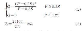
3.2 SCS水文模型计算
根据SCS水文模型的产流计算公式(2)可知,径流深度计算需要确定研究区的降雨量P。降雨量由重庆市主城区辖区内4个国家级地面站点记录的1981—2010年累年值月值数据获取,以月降雨距平百分率<-20%,-20%~20%,>20%为指标[19],降雨月型划分为枯水期、平水期、丰水期。根据主城区4个地面站点的全年各月降雨数据的平均值,结合重庆市全年降雨特点,得出1月份属枯水期,4月份属平水期,6月份属丰水期,降雨量分别为19.68,99.70,190.93 mm,本文以这3期降雨量来模拟主城区地表径流。
根据SCS水文模型要求,运用ArcGIS软件处理重庆市主城区相关数据,利用公式(2)模拟主城区2000年、2005年、2010年和2015年的地表径流深度(图3)。从不同降雨期分析径流深度空间演化趋势可知,枯水期主城区径流深度较低,2000—2015年径流深度低于14.58 mm,未产生径流的地区分别占主城区总面积的27.03%,25.96%,25.48%,23.93%,呈下降趋势,这些地区主要为主城区南北走向的山脉,西部的缙云山和中梁山、北部的龙王洞山、长江以北的铜锣山及东南部的莲花山,这些山脉的土地利用类型多为林地,径流系数较低,地表径流产生所需最小降雨量较大,在枯水期很难形成地表径流。从平水期和丰水期模拟结果可知,随着平水期、丰水期降雨量增加,主城区径流深度有明显提升,平水期和丰水期主城区径流深度分别为12.70~93.74 mm,62.45~184.85 mm。
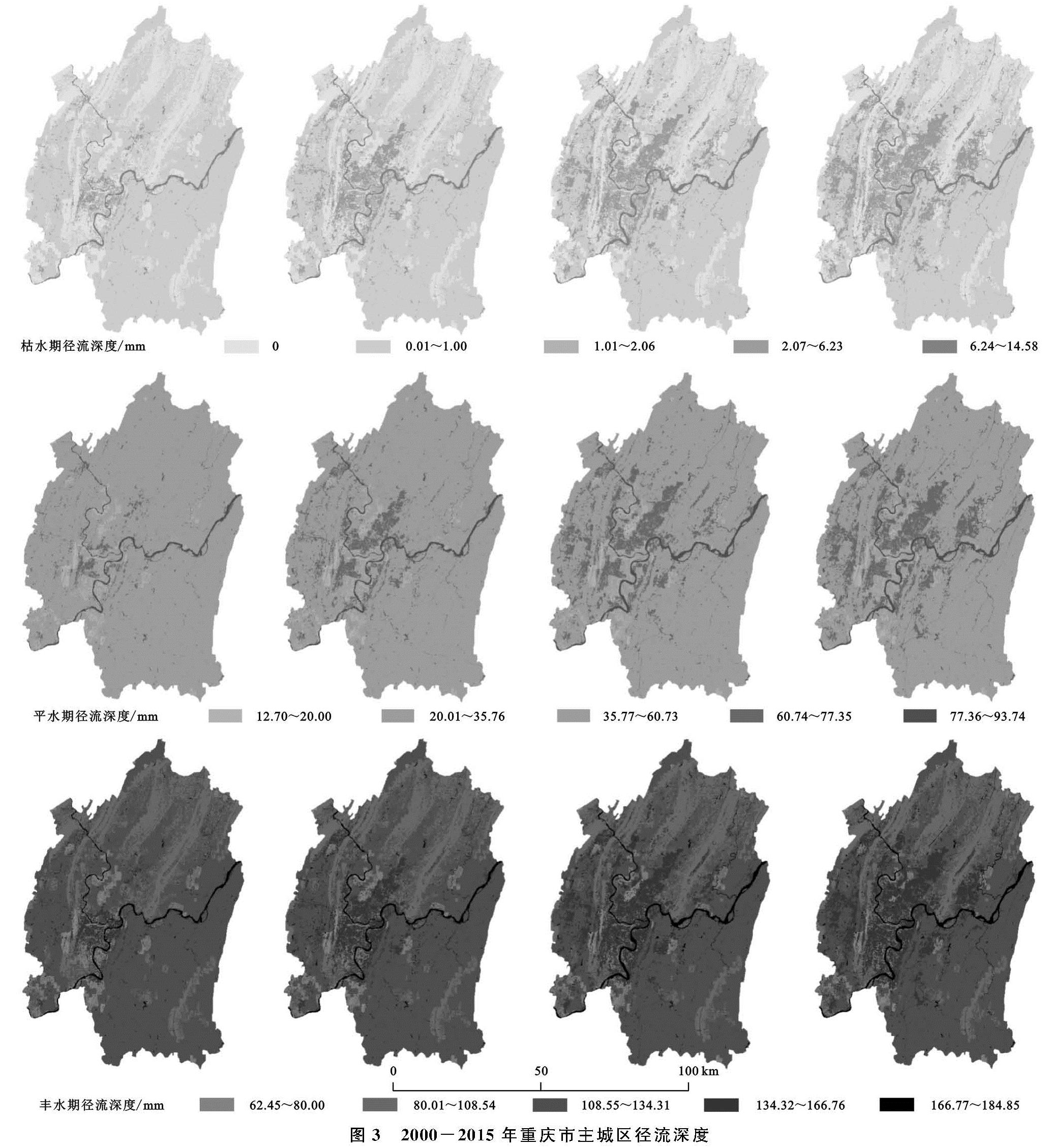
从不同降雨期2000—2015年重庆市主城区径流量统计结果来看(表4),主城区2000—2015年径流量显著增长,枯水期、平水期、丰水期径流量范围分别为(456.20~887.93)万m3,(24 974.80~27 308.37)万m3,(67 789.15~70 960.97)万m3; 2000—2015年主城区在枯水期、平水期、丰水期径流量涨幅分别达到了94.63%,9.34%,4.68%; 同年随降雨的增加,径流量也呈增长趋势,枯水期与平水期、丰水期比较尤为明显。
3.3 土地利用变化对地表径流的影响
SCS模型模拟结论证实,重庆市主城区径流量持续增长(表4),为探究主城区各土地利用类型在不同降雨期的产流能力差异,分别对主城区各土地利用类型在枯水期、平水期、丰水期的平均径流深度(表5)和总径流量(图4)进行分析。
从产流能力来看,各土地利用类型的产流能力存在明显差异,从弱到强排序为:林地、草地、耕地、未利用土地、建设用地、水域。
从径流量来看,主城区枯水期地表径流量较多的土地利用类型为水域、耕地及建设用地,由于耕地面积减少,径流量逐年减少,相反建筑用地径流量随着面积增加而升高; 各土地利用类型在平水期和丰水期的径流量较多的是耕地、林地及建设用地,林地虽然产流能力弱,但因其面积大,径流量变化趋势与林地面积动态变化状态基本上维持一致。
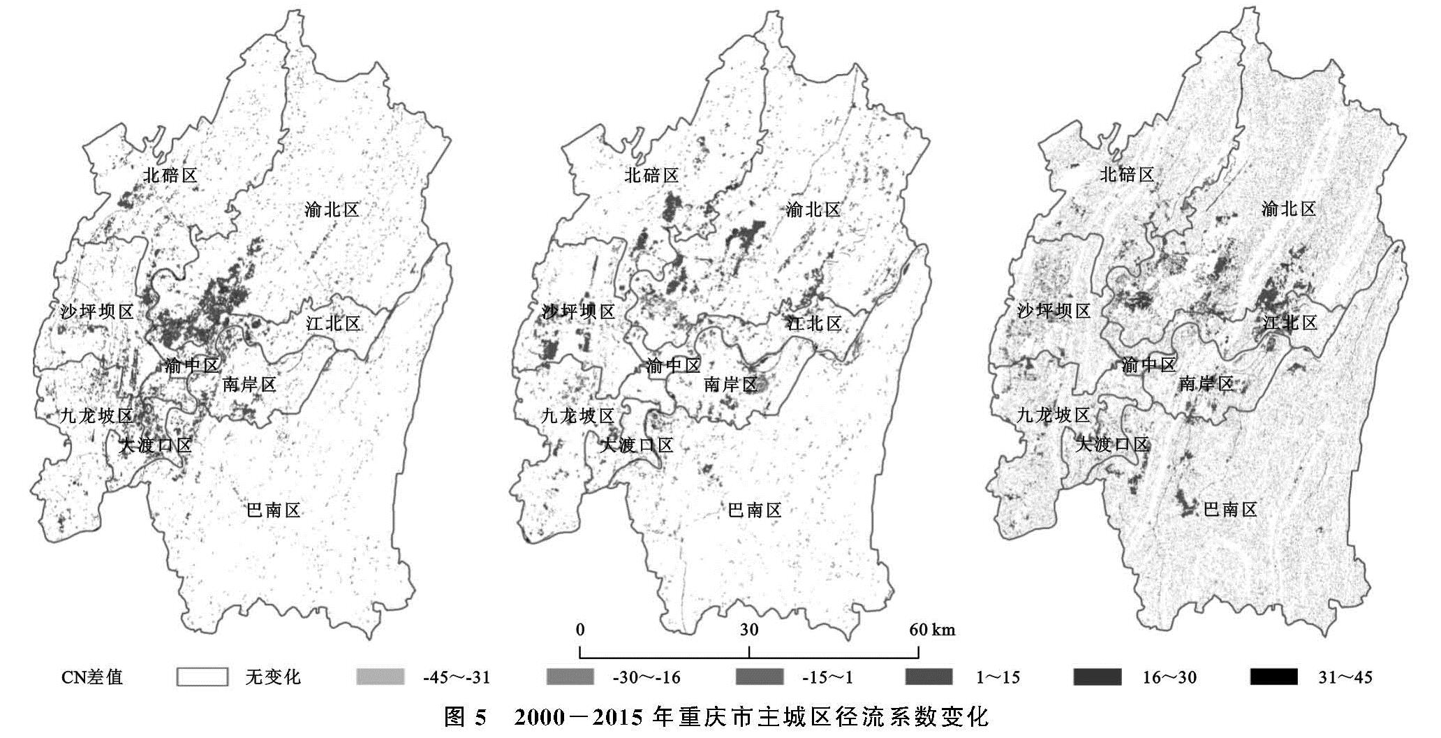
本文比较了2000—2005年、2005—2010年、2010—2015年重庆市主城区各地块的径流系数变化情况,分析主城区土地利用变化对地表径流空间演化趋势的影响,径流系数的空间变化情况可以体现研究时段内地表径流的演化趋势。从图5可以看出,2000—2015年径流系数未发生变化的区域占主城区总面积90%以上,说明这些地块的土地利用类型保持不变。径流系数降低的区域随机零星分布,大部分是由于退耕还林导致土地利用类型发生改变,导致径流系数减小。径流系数升高的区域主要围绕渝中区呈中心辐射发散分布,2000—2015年主城区建设用地从230.32 km2增至932.55 km2,导致径流系数较高的地块增加; 2000—2005年径流系数升高区域主要集中于渝北区西南部,2003年重庆北站正式动工,导致城市向北扩张; 2005—2010年径流系数升高区域主要在北碚中部地区、渝北中部地区及沙坪坝西部地区,2004年重庆市提出大学城“三步走”建设计划,导致沙坪坝西部地区土地利用变化加剧,建设用地聚集增加,地表径流系数升高; 2010—2015年径流系数升高区域主要为渝北区南部地区、江北区中部地区及巴南区西部,在2010年,国务院批准了重庆市两江新区的建设,打造其为内陆地区对外开放的桥头堡,建筑用地对其他用地的侵占明显,导致其径流系数显著升高。总体来说,2000—2015年主城区径流系数增加区域主要分布于“两江四山”之间较平坦地区,主要呈现南北延伸趋势。
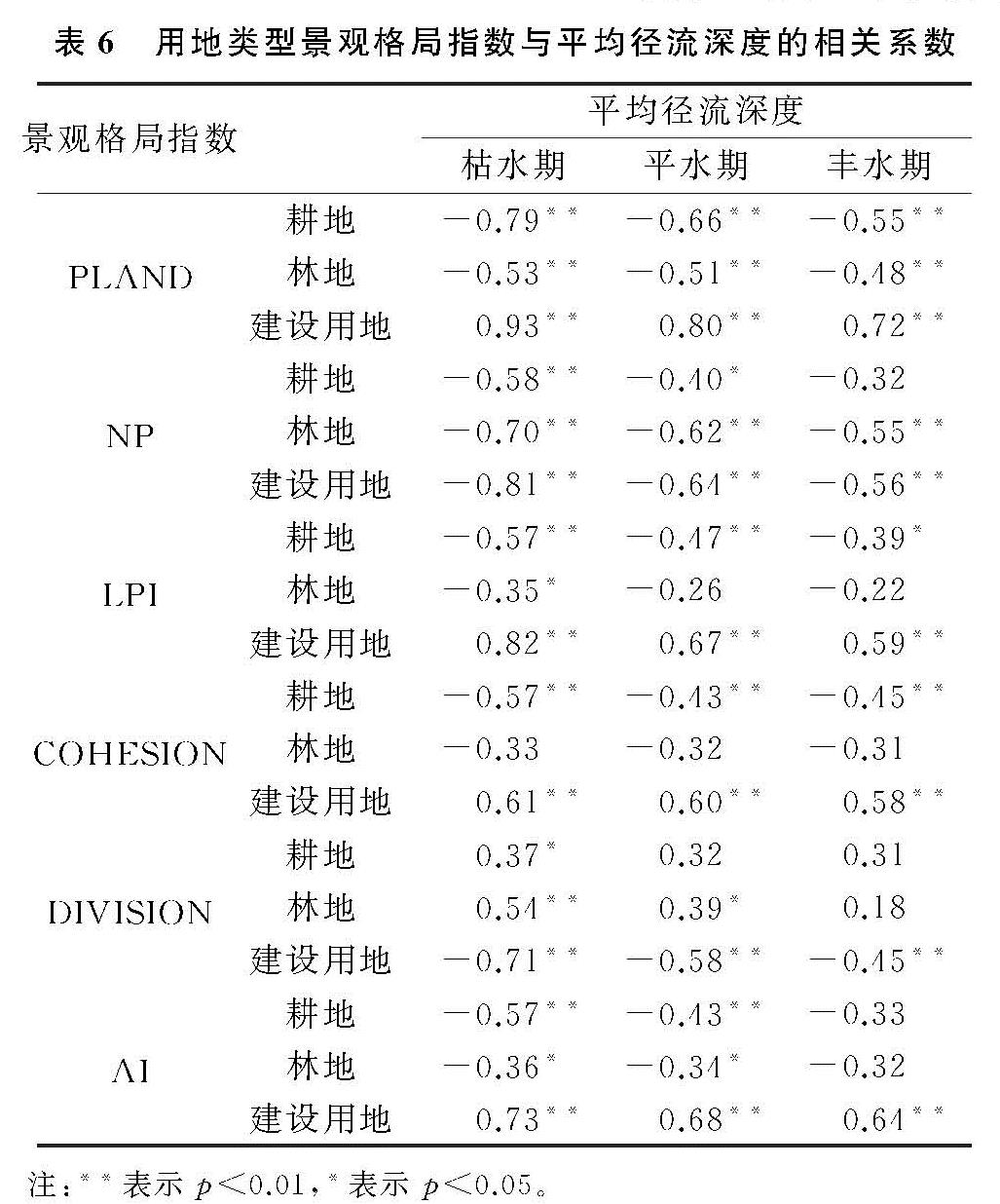
为进一步分析土地利用变化对地表径流的影响,主城区按行政区划划分为渝中区、江北区、沙坪坝区等9个部分,选择各区县的耕地、林地、建设用地及其平均径流深度; 参考有关学者[20]的研究,由Fragstats 4.2软件计算PLAND(斑块所占比例)、NP(斑块数量)、LPI(最大斑块指数)、COHESION(斑块结合指数)、DIVISION(破碎度)及AI(斑块聚集度)6个景观格局指数,共获得54组数据。利用SPSS软件对土地利用类型景观格局指数和平均径流深度进行相关性分析。由表6可知,经过相关系数显著性检验,耕地、林地、建设用地景观格局指数与平均径流深度的相关系数随降雨增加呈减小趋势,建筑用地相关系数比耕地、林地较大; 其中平均径流深度与耕地、林地的PLAND,NP,LPI,COHESION,AI呈负相关,与DIVISION呈正相关; 平均径流深度与建设用地PLAND,LPI,COHESION,AI具有极显著正相关性,相关系数范围分别为:0.93~0.72,0.82~0.59,0.61~0.58,0.73~0.64,与建设用地的NP,DIVISION呈极显著负相关,相关系数范围分别为-0.81~-0.56,-0.71~-0.45。建设用地相较于耕地和林地对地表径流的影响更加明显,耕地和林地下渗和拦截径流能力较强,产流能力较弱,建设用地产流能力较强,在建设用地持续增长过程中,合理增加其斑块数量、斑块破碎度,减少大面积建设用地聚集,从而减少地表径流。
图5 2000-2015年重庆市主城区径流系数变化
表6 用地类型景观格局指数与平均径流深度的相关系数