3.1 1969-2019年风蚀气候侵蚀力的时间变化特征
3.1.1 年际变化特征
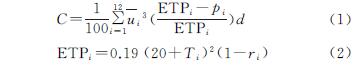
C值是风蚀受各气象因子影响的综合反映,其年际变化特征也反映气象因子的波动特征,年均C值的大小也反映该区风蚀气候侵蚀力的潜力。图2为1969—2019年东疆地区6个气象站点平均风蚀气候因子指数的年变化特征及年代际变化趋势。
从总体看,近50 a东疆地区的C值呈现波动式下降趋势(p<0.01),年递减速率为1.39,最大值出现在1972年为150.67,2016年达到最小值为43.16,1969—2019年C值的平均值为76.92,1969—1978年C均值均大于100,超过了风蚀气候侵蚀力“极重”(风蚀气候因子指数≥100)的分级标准[16],说明在1978年以前东疆地区风蚀强度较大。1988年以后逐年下降至平均值以下。不同时段C值的倾向程度不同,1970s,1980s,1990s及2010s这4个年代的10 a倾向率均为负值,分别为-21.344,-12.988,-26.138,-10.058,其中1970s,1990s和2010s的C值倾向率通过了α=0.01的显著性检验,说明这3个时段C值下降趋势显著。2000s的倾向率为非负值,且未能通过显著性检验,说明该时段内C值上升趋势不显著。
图2 1969-2019年东疆地区风蚀气候侵蚀因子年际和年代际变化趋势
图3为1969—2019年北疆地区17个气象站点风蚀气候侵蚀因子指数的年际变化特征及年代际变化趋势。从图3可以看出,北疆地区以每年1.49的速率波动下降(p<0.05),最大值为106.95(1983年),2010年出现最小值为-47.02,C值多年平均值为29.85,2005年以后逐年下降至平均值以下。北疆地区C值的变化过程总体呈现3个阶段,第一阶段1969—1975年平稳上升,第二阶段1975—2012年呈现快速下降趋势(p<0.05),第三阶段2012年以后呈现显著上升趋势(p<0.05)。
数据计算得,1970s和2010s两个年代风蚀10 a气候倾向率分别为43.091,58.487,均大于0,其中2010s的倾向率通过α=0.05的显著性检验,说明2010s的C值呈现显著上升趋势; 1980s,1990s,2000s的10年倾向率分别为-9.361,-9.021,-11.175均小于0,其中2000s的倾向率通过了α=0.01的显著性检验,说明2000s的C值呈下降趋势显著。
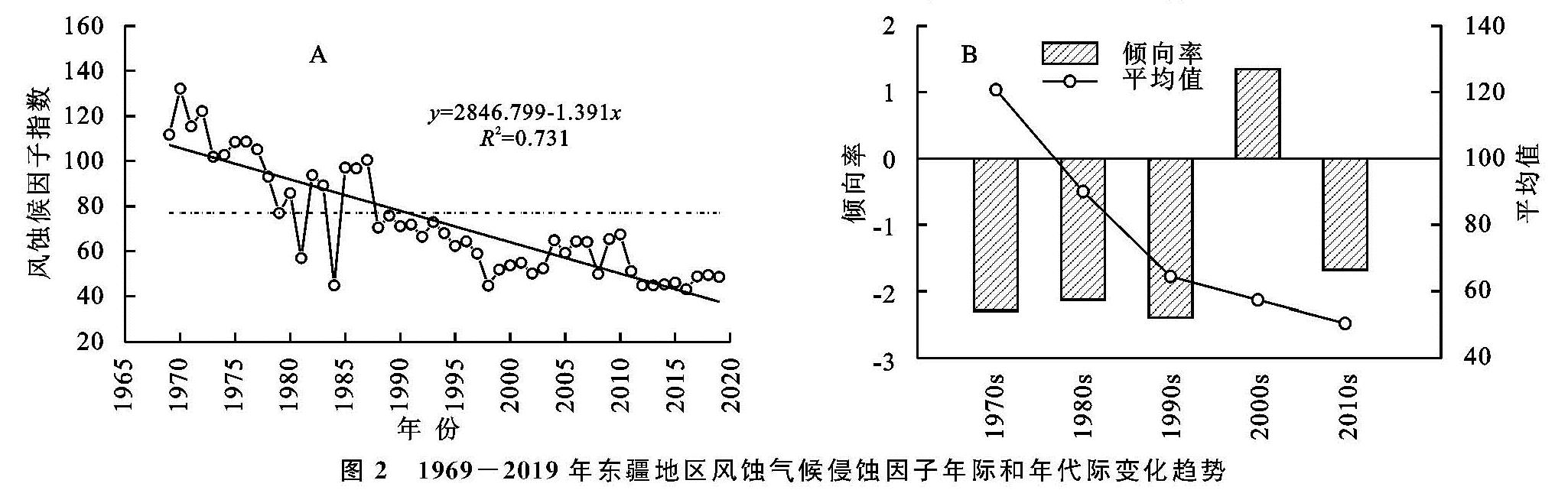
由图4B可知,1969—2019年南疆地区风蚀气候侵蚀力的倾向率呈增大趋势,说明近50 a来南疆地区风蚀气候侵蚀力大小虽然总体呈下降趋势,但是风蚀气候侵蚀力上升潜力在逐渐增大。1970s,1980s,2000s这3个年代的10 a倾向率分别为-9.30,-6.12,-0.44均小于0,其中1970s的倾向率通过了α=0.01的显著性检验,说明在1970s的C值下降趋势最为显著。1990s和2010s的10 a倾向率均为正值分别为2.489,6.872,仅2010s的C值倾向率通过了显著性检验(α=0.01),说明2010s的风蚀气候侵蚀力上升倾向显著。
图3 1969-2019年北疆地区风蚀气候侵蚀因子年际和年代际变化趋势
图4 1969-2019年南疆地区风蚀气候侵蚀因子年际和年代际变化趋势
从图5A可以看出全疆C值整体呈现波动下降趋势(p<0.01),递减速率为每年1.14,最大值为78.79(1975年),最小值为2.95(2012年),全疆C值多年平均值为40.54,1985年以前C值大于平均值,1985—1995年在平均值范围内波动,1995年之后逐年下降至平均值以下。从图5B可以看出,1970s和2010s的倾向率大于0,2010s的10 a倾向率为20.72,通过了α=0.05的显著性检验,说明该时段C值上升倾向显著。1980s,1990s,2000s这3个时段的10 a倾向率分别为-9.51,-10.89,-0.42均小于0,均未通过显著性检验,说明该时段风蚀气候侵蚀力有下降倾向但是并不显著。
图5 1969-2019年新疆全区风蚀气候侵蚀因子年际和年代际变化趋势
对比图2—5发现,新疆全区及东疆、北疆、南疆3个分区的风蚀气候侵蚀力总体呈现波动下降的趋势,但北疆和南疆地区在2012年以后C值均有显著的回升趋势(p<0.01)其中南疆地区年均风蚀气候侵蚀力早在1996年左右已有上升的趋势。全疆多年平均C值和其递减速率从小到大排序为南疆<北疆<东疆,究其原因,主要与新疆地区大风口带的分布有很大关系,由于新疆境内有九大风区,其中东疆区内就分布有4个大风区,包括哈密北戈壁风区、哈密南戈壁风区、百里风区及吐鲁番西部风区,常年平均风速偏大,导致东疆地区哈密站、红柳河站及吐鲁番站点的C值远高于其他站点,从而致使东疆地区平均C值高于疆内其他地区。北疆地区的阿拉山口站和达坂城站同样处在风区,C值也远高于其他站点。
3.1.2 年内分配特征
新疆全区C值的月际及季节变化特征见图6。由图6A可知。新疆地区风蚀气候侵蚀力具有明显的季节特征,从季节变化特征来看,C值在季节上的变化表现为春季>夏季>秋季>冬季。C值的月变化特征显示为:1—5月C值随着月份的增大而逐渐上升,其中4月和5月急剧增长,5月达到最大值为9.068; 6月开始下降,1月达到最小值为-4.481。
究其原因,由于新疆地区风蚀气候侵蚀力的季节变化特征与地区特殊的气候特征有密切的关系。新疆地区冬季气温偏低,积雪较厚,地表受积雪的保护而降低了风蚀的发生,春季和夏季的平均风速偏高,且由于气温回暖,春夏季节的空气相对湿度偏低,降雨较少,易发生土壤风蚀。
3.2 1969-2019年风蚀气候侵蚀力的空间分布特征
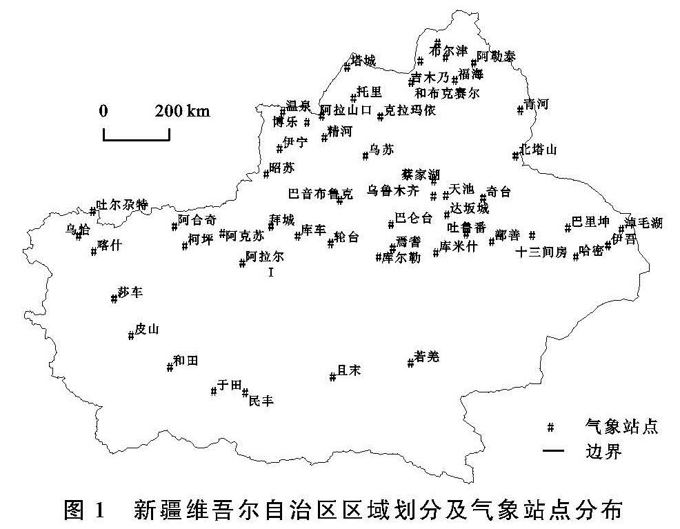
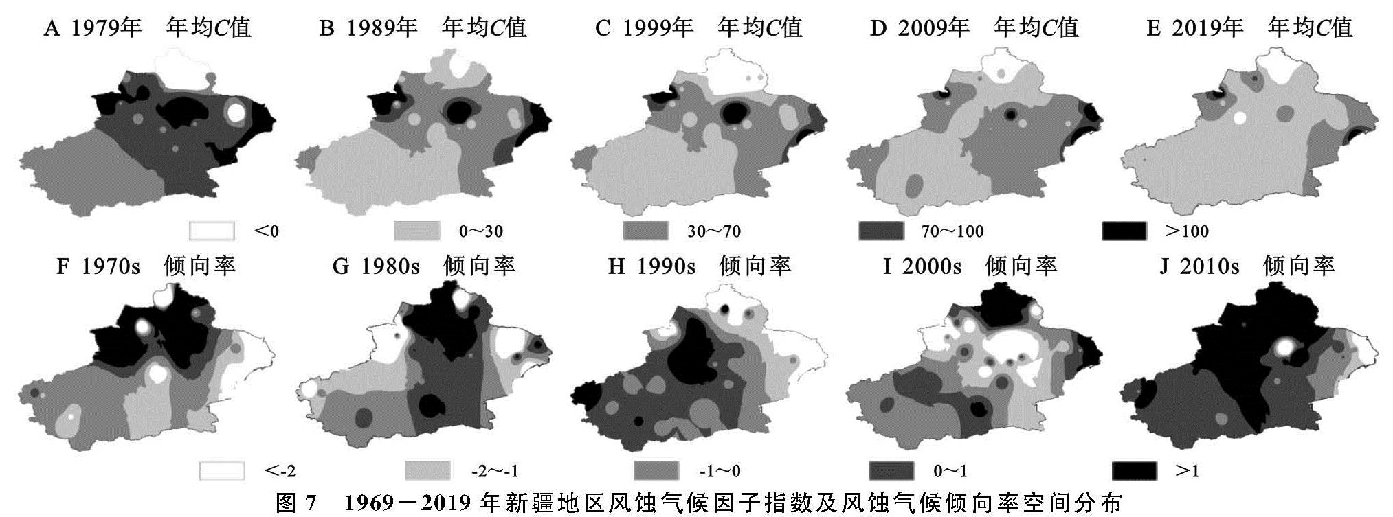
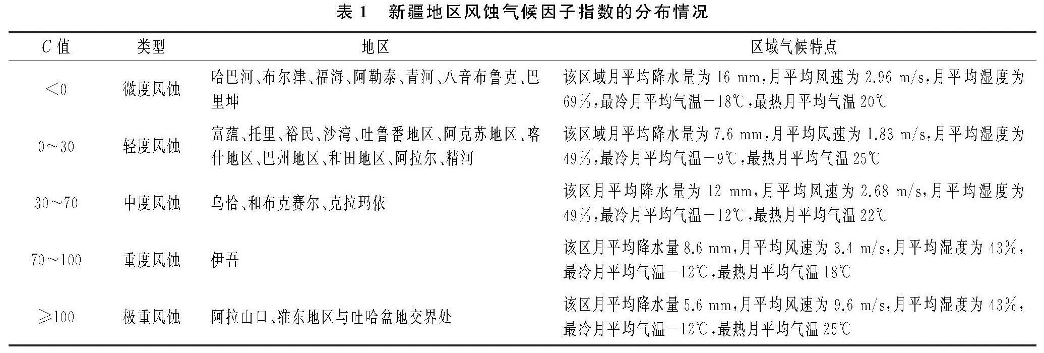
图7给出了新疆地区1969—2019年41个气象站点风蚀气候因子(A,C,E,G,I)及气候倾向率(B,D,F,H,J)的空间变化特征,新疆各区的风蚀情况见表1。从风蚀气候因子整体的分布状况可以看出,风蚀气候因子的空间分布规律与该区域风蚀地貌的分布有极大的关联性,也与风速的分布规律密不可分。根据统计计算得,1969—2019年41个气象站点的C值的变化范围为-200~355,从年均C值的空间变化图中可以看出,风蚀气候侵蚀力出现明显的3个高值区,一是以阿拉山口和克拉玛依站为中心的博州地区及塔城南部地区,二是以达坂城和奇台站为中心的准东地区与吐哈盆地交界处,三是以淖毛湖和红柳河站为中心的东疆东部地区,其中最大值出现在阿拉山口,超过风蚀气候侵蚀“极重”的分级标准,属于极重侵蚀区,另外,全区有4个站点C值≥100属于极重侵蚀区,占总气象站点的10%。C值的10 a平均倾向率变化范围为-6.172~7.631,其中有16个气象站点的平均倾向率为非负值,占总站点数的39%,从倾向率的空间分布图中可以看出,风蚀气候倾向率的高值区主要分布在新疆的东北部和南疆西南角地区,这与韩柳等[19]的研究结果一致,其中以阿勒泰地区的倾向率最高,说明该区风蚀气候侵蚀力的增长趋势明显。
图7 1969-2019年新疆地区风蚀气候因子指数及风蚀气候倾向率空间分布
对比图7A,C,E,G,I可以看出,新疆地区C值总体呈现从东向西递减,从南向北递增的空间格局,1999年之前全疆C值的南北分布大致以天山为界,北疆除阿勒泰地区之外区域的风蚀气候因子均值大于30,风蚀等级较高,而南疆地区的风蚀气候因子均值在30以内,风蚀等级较低。自2000年以后全疆C值明显降低且不存在明显的区域界线,全区风蚀等级均有所下降,其中C值≥100的极重侵蚀地区范围明显缩小,仅分布在准东地区与吐哈盆地的交界处及阿拉山口,与Yang[3]、李达净[20]等的研究结果一致。
由表1可知,全疆风蚀范围较广,类型集中,主要以微度及轻度侵蚀为主,从各类风蚀区的区域气候特点可以看出,极重度风蚀区的风速远远高于其他地区,相对湿度、温差、降水量和气温等值也低于其他区域,但差异较风速差异小,说明风蚀气候侵蚀力的大小与风速大小有密切的关系,这与前人的研究结果一致[9-14]。
3.3 风蚀气候侵蚀力的突变性
大量事实表明气候不是缓慢变化的,而是从一种稳定状态跳跃式地转变到另一种稳定状态,称为气候突变现象[21],M-K检验法是世界气象组织推荐的用于提取序列变化趋势的有效工具[22]。图8为1969—2019年新疆全区风蚀气候因子指数的M-K突变检验结果。
图8 新疆维吾尔自治区和3个大区风蚀气候因子指数的突变特征
由图8可以看出,新疆地区风蚀气候因子指数的UF和UB曲线在1993年出现交点,且交点在α=0.01的信度曲线之内,说明新疆地区风蚀气候侵蚀力在1993年开始突变,同年下降趋势超过显著性水平0.01的临界线,说明新疆地区C值自1993年开始显著降低。北疆和南疆地区风蚀气候侵蚀力分别在1998年和1975年发生突变,分别在2006年和1976年进入显著下降趋势; 东疆地区风蚀气候侵蚀力在1979年以后显著下降,无突变。
从气候变化的角度看,近50 a来新疆地区气候变化状况与该区风蚀气候侵蚀力的突变息息相关。新疆地区的气候在向暖湿方向发展,自1998年起进入显著暖湿化的发展趋势[23],其中,北疆和东疆地区的C值突变时间与气候突变具有同步性,而南疆地区C值发生突变的时间则早于气候湿暖化的突变时间点,说明北疆和东疆地区风蚀气候侵蚀力对气候变化的敏感性大于南疆地区,此外根据资料显示,20世纪末期,南疆地区的沙漠化正在以年均增加0.93%的速度侵蚀塔克拉玛干沙漠南缘,从且末至若羌、和田普遍出现了沙漠南移,绿洲后退的情景[24],而南疆地区风蚀气候侵蚀力在1997年左右出现上升趋势,由此说明对于南疆地区,土壤风蚀作用已经不再是由气候因素所主导而发生。