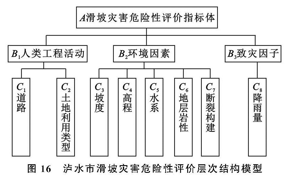
2.2 评价因子的选取
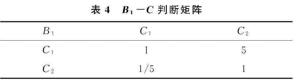
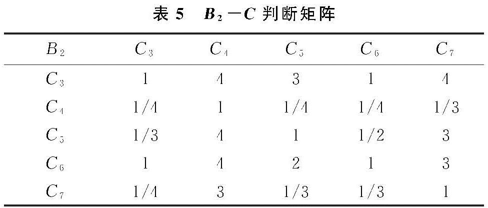
滑坡是一种非线性动力学过程,影响滑坡发生的因素多而复杂。本文以泸水市235起滑坡灾害点为基础,参阅大量文献资料[13-14],综合考虑泸水市滑坡灾害的发生过程、发育环境等因素,选取环境因素、人类工程活动、致灾因子三大类评价因素作为影响因子,环境因素包括坡度、高程、水系、地层岩性、断层构造和NDVI,人类工程活动:选取道路和土地利用类型作为人类工程活动中的量化指标; 致灾因子:泸水市滑坡主要为降雨诱发,故选取降雨量作为致灾因子。
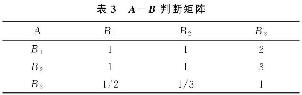
利用GIS空间相关性分析工具,对选取的评价指标进行相关性分析,剔除相关性强的因子,可以使评价指标的选取更为合理,提高评价结果的精度。基于ArcGIS,对各评价因子进行波段集统计,然后计算各评价因子图层间的协方差矩阵和相关矩阵,得到各指标因子间的相关系数R,当|R|≤0.3时,表示相关性较弱或者不相关[15]。由表2可知,NDVI与坡度、高程等6个因子相关系数的绝对值大于0.3,其他各指标因子间的相关系数的绝对值均小于0.3,故将NDVI因子剔除,最终确定以坡度、高程、道路距离、水系距离、地层岩性、断层构造、土地利用类型以及降雨量共8个因子作为评价指标,构建滑坡灾害危险性评价指标体系。
2.3 评价因子的提取与量化
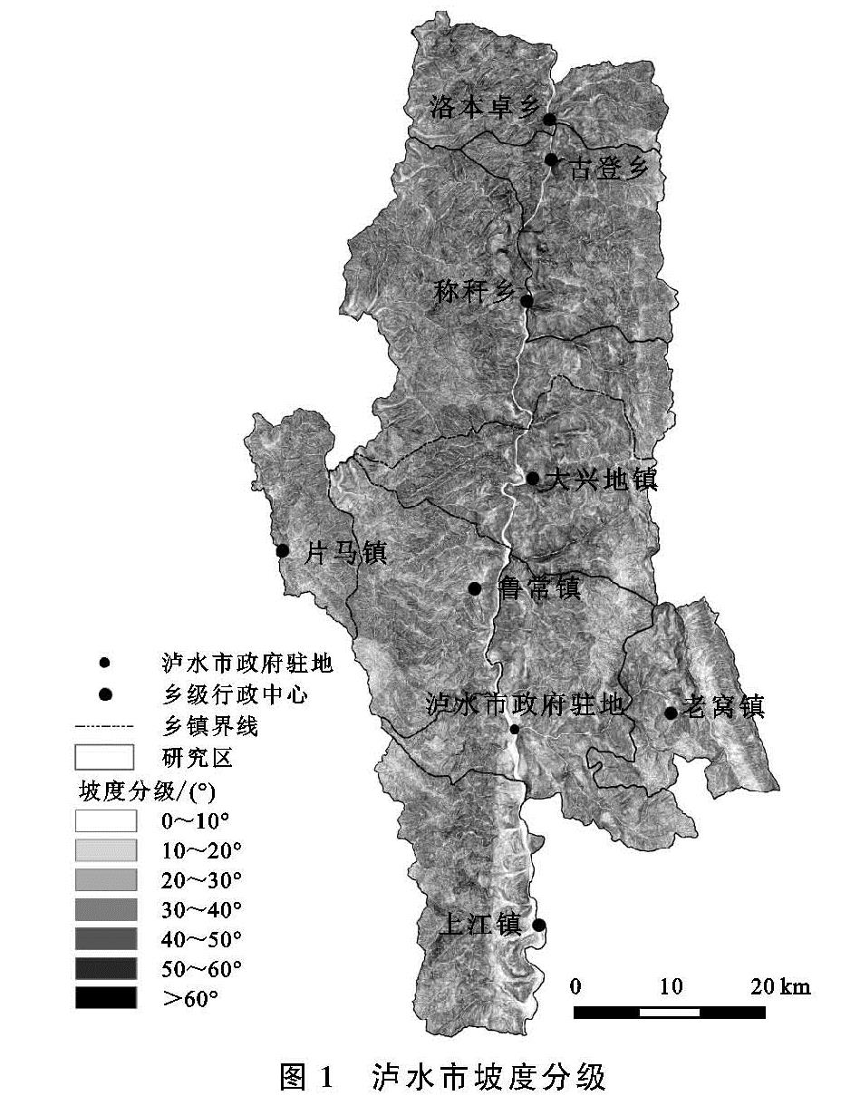
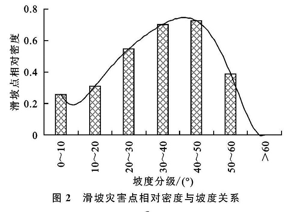
2.3.1 坡 度 坡度是影响滑坡发育的重要因素,直接决定着斜坡的稳定性。坡度较小的地区,不易发生滑坡灾害,随着坡度的增大,包括坡体自重在内的剪切力也随之增大,为松散堆积物提供了较大的势能,坡体稳定性降低,发生滑坡灾害的可能性增大。根据研究区实际情况,将坡度划分为0°~10°,10°~20°,20°~30°,30°~40°,40°~50°,50°~60°,>60°共7个等级(图1),然后分析坡度与滑坡灾害点相对密度的关系,得到图2的直方图,结果显示:坡度在30°~50°范围内的滑坡点相对密度较大,说明该区域发生滑坡的可能性较大。
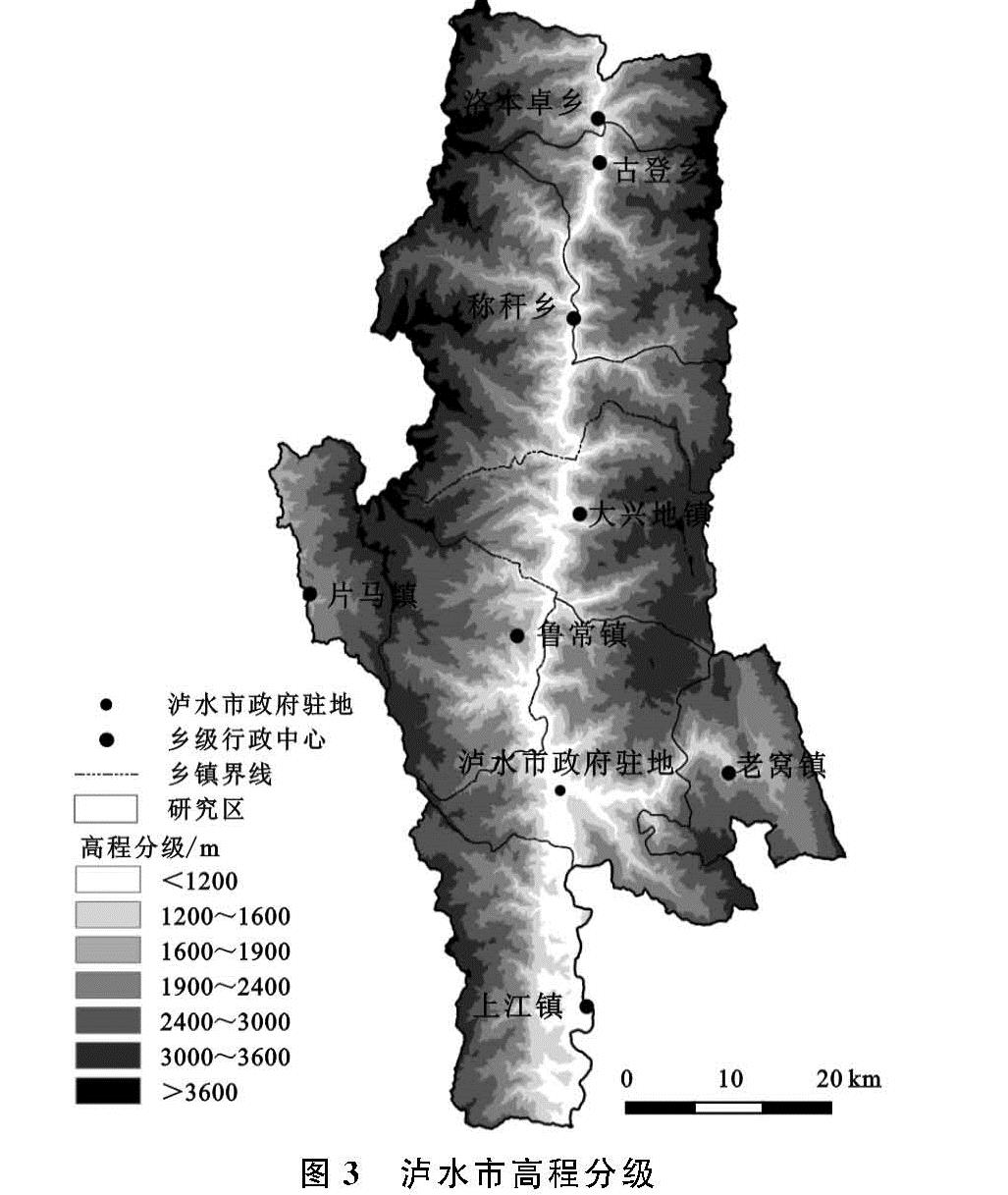
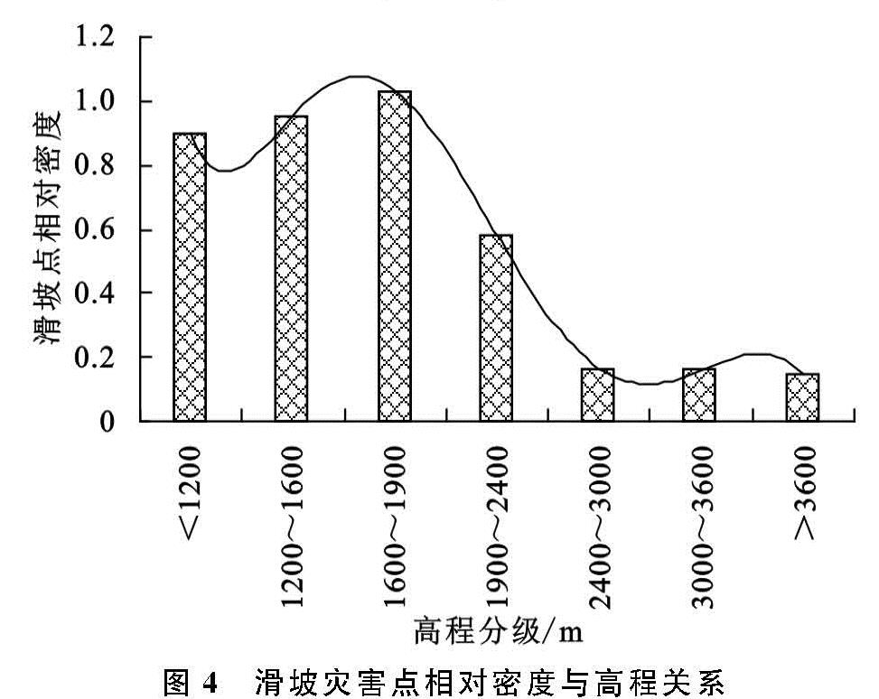
2.3.2 高 程 高程对滑坡灾害的发生有着重要影响。高程不同,会导致降水、气温、植被以及土壤类型等因素均不相同。泸水市山高谷深、地形复杂、海拔高差达3 000 m以上,随着高程增加,形成复杂的山地垂直自然带。利用GIS技术,根据不同垂直自然带,将高程划分为7个分带(图3),并分析各个高程分带与滑坡灾害点相对密度的关系(图4)。由图3—4可知:高程在0~1 900 m范围内,滑坡灾害点相对密度较大,说明滑坡易发生在此高程范围内; 当高程>1 900 m时,滑坡灾害点相对密度较小。由遥感影像发现,海拔在1 900 m以上时,居民点分布很少,高程越高,人类活动强度越小; 而海拔小于1 900 m的地区,居民点分布密集,人口密度较大,发生滑坡灾害的可能性较大。
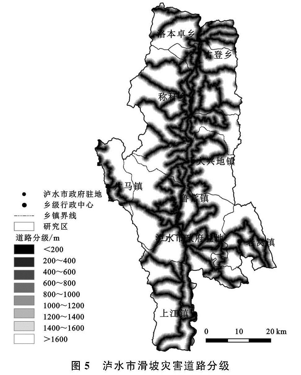
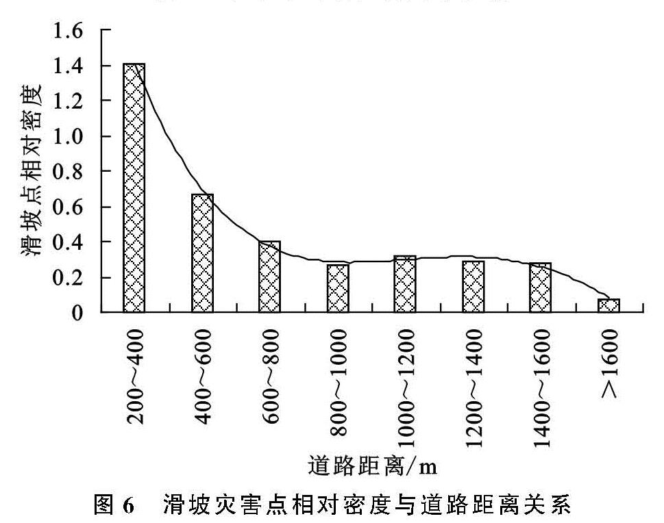
2.3.3 道 路 受自然环境的限制,泸水市人地矛盾突出,山路修建过程中需要开挖边坡,会改变山体原有的岩层结构,使斜坡体抗剪能力降低,形成不稳定斜坡或危岩,在暴雨的情况下,极易发生滑坡灾害[16]。在ArcGIS软件支持下,对道路数据建立以200 m为间隔的缓冲区(图5),各缓冲区间内滑坡灾害点的相对密度见图6,结果表明,距道路越近,滑坡灾害发生的次数越多。滑坡灾害的发生,与距道路距离有密切的关系,修建道路等人类工程活动会干扰、诱发滑坡灾害。
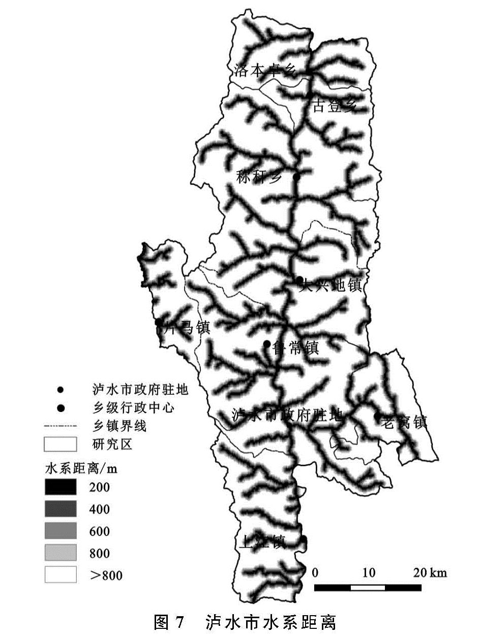
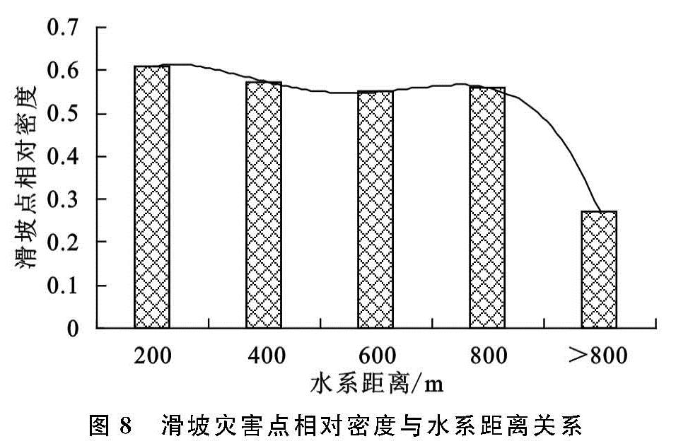
2.3.4 水系 水系是影响滑坡发育的重要因素,主要表现在河流的侵蚀和掏蚀作用会影响斜坡的稳定性,增大滑坡灾害发生的概率[17]。本文通过DEM提取泸水市水系,以200 m为间隔,基于ArcGIS建立河流缓冲区(图7),分析水系距离和滑坡灾害点相对密度的关系(图8)。结果表明:研究区滑坡灾害点随距水系距离的增大而减小,其中0~800 m范围内滑坡灾害点相对密度较高,说明该区间内易发生滑坡,当水系距离>800 m时,滑坡灾害点相对密度很小,河流对滑坡发生的控制力减弱。
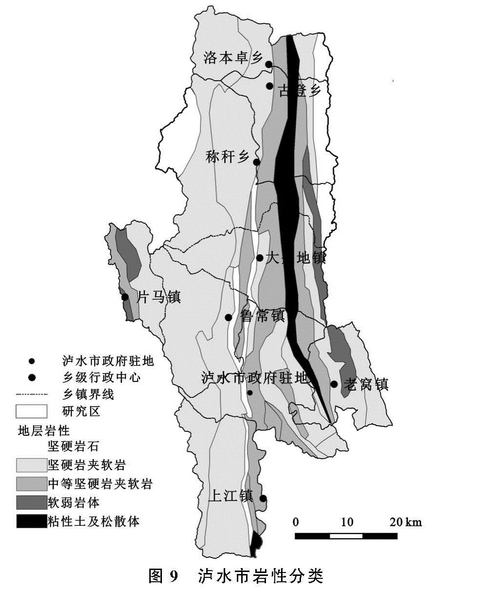
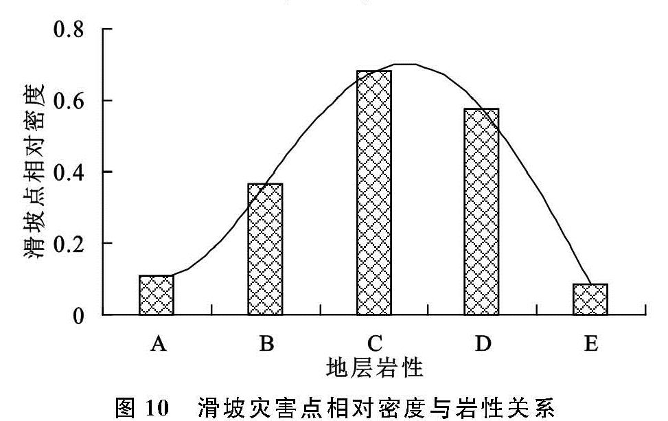
2.3.5 岩 性 地层岩性是区域滑坡灾害分布的主控因素。不同的岩土体性质不同,其坚硬程度、物理化学性质和抗风化能力等均不相同,导致滑坡发生的概率也不同。考虑到将岩性指标定量化分析,本文以地层组为基本单位,根据岩层的坚硬程度、物理化学性质等,将泸水市岩土体划分为5种类型:A(坚硬岩体)、B(坚硬岩夹软岩)、C(中等坚硬岩夹软岩)、D(软弱岩体)、E(粘性土及松散体)[18],利用ArcGIS空间分析功能生成研究区地层岩性分布图(图9)和滑坡灾害点相对密度直方图(图 10),结果显示:坚硬岩夹软岩、中等坚硬岩夹软岩和软弱岩体的滑坡灾害点相对密度较大,说明滑坡易发生在以板岩、片岩、灰岩、砂岩、页岩、泥岩以及千枚岩等软弱岩层或软硬相间的岩层中,这是因为软硬岩夹层会使软岩成为天然的滑床,有利于滑坡灾害的发生,研究区内粘性土及松散体稳定性较差,通常只能形成低缓的斜坡,不易发生滑坡灾害,坚硬岩体组成的斜坡稳定性很好,抗风化能力较强,不易破裂,滑坡灾害也不易发生。
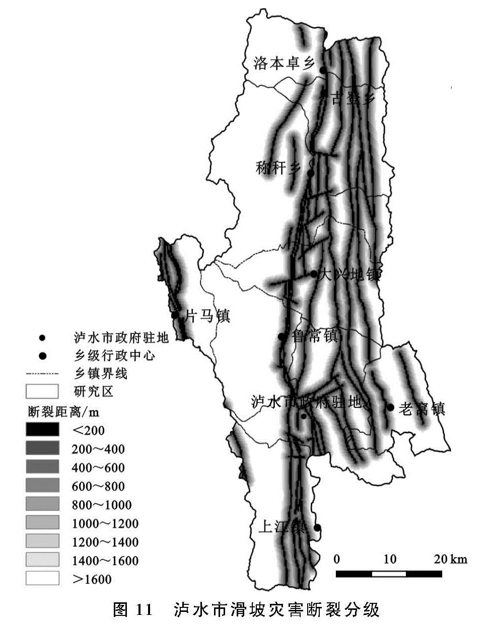
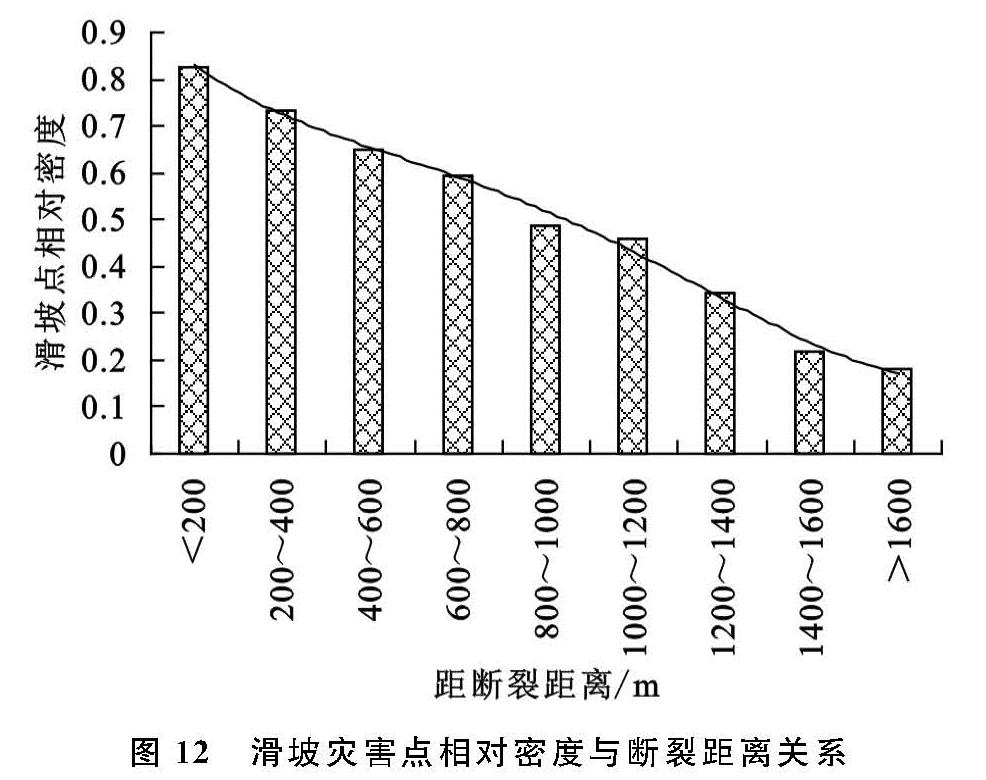
2.3.6 断裂构造 断裂构造是滑坡灾害发育的重要控制因素。断层构造会破坏岩层的稳定性、完整性和连续性,导致断裂带周围岩体破碎,松散物堆积,增大滑坡灾害发生的可能性。泸水市断裂构造主要以南北向为主,东西向分布较少。以200 m为间隔建立缓冲区(图 11),基于ArcGIS的数据统计功能,分析断裂距离与滑坡灾害点相对密度的关系(图 12)。结果显示:距离断裂带越远,滑坡灾害点相对密度越小,在0~600 m区间内滑坡灾害点相对密度较大,滑坡灾害较易发生。
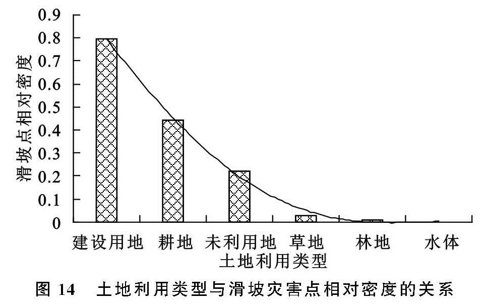
2.3.7 土地利用 不同土地利用类型对滑坡发生的影响程度不同。通过对2018年RapidEye遥感影像进行目视解译,获得研究区土地利用类型分布图(图 13)。分析建设用地、耕地、未利用地、草地、林地以及水体与滑坡灾害点相对密度的关系(图 14)发现:建设用地和耕地发生滑坡灾害的频率最高,泸水市陡坡耕种及不合理的工程建设破坏地表形态,增加人工切坡,加剧水分下渗,使地表水体流失严重,极易诱发滑坡灾害。
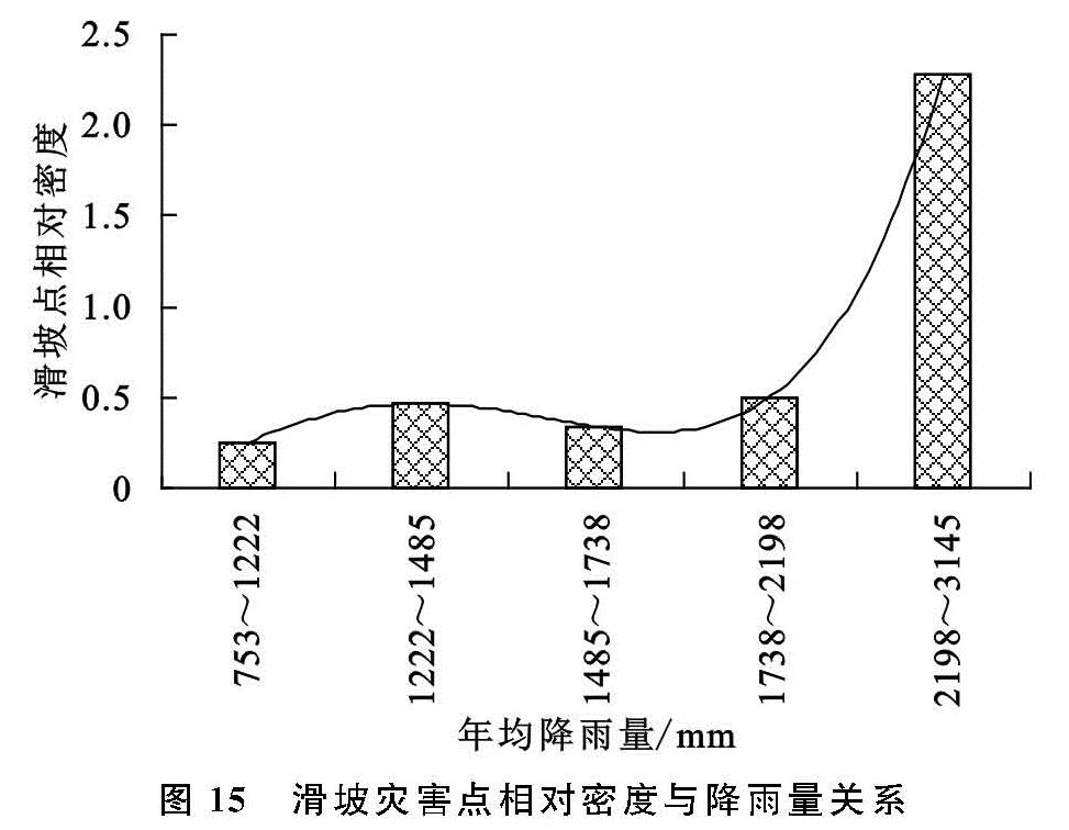
2.3.8 降雨量 降雨是滑坡灾害发生的主要诱因,是滑坡灾害危险性评价中最具代表性的评价因子之一。大量雨水下渗导致斜坡岩土体的抗剪强度降低,诱发坡体发生变形和位移,造成滑坡灾害的发生。本文采用泸水市气象站点多年年均降雨量数据作为评价指标,基于ArcGIS对降雨数据进行空间插值,得到泸水市年降雨量分级,统计不同年降雨量范围内的滑坡灾害点相对密度(图 15)。结果显示:研究区内滑坡灾害的发生整体上随降雨量的增加而增加,尤其是当年均降雨量在2 198~3 415 mm范围内,滑坡灾害点相对密度较大,也与统计资料中泸水市暴雨型滑坡灾害分布最为广泛的结论相吻合。