3.1 景观格局时空特征分析
3.1.1 整体分析
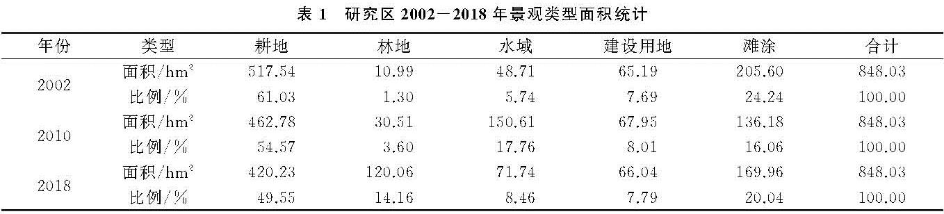
表1 显示出2002—2018年广阳岛景观面积生了巨大变化,主要体现为广阳岛耕地面积持续减少,林地面积持续增加,建设用地类型和空间分布发生了巨大变化,水域面积和滩涂面积也发生了很大变化。2002年耕地面积为517.54 hm2 ,2010年为462.78 hm2 ,2018年为420.23 hm2 ,耕地比例由2002年61.03%下降到2018年49.55%,下降了11.48%。耕地减少主要是由于岛上居民整体搬迁,耕地转化成了林地。研究区林地2002年为10.99 hm2 ,2010年为30.51 hm2 ,2018年最高为120.06 hm2 ,2010—2018年期间林地变化面积最大,增长幅度达到了10.56%,增长之快尤为罕见,这主要得益于岛上居民外迁,广阳岛林地主要集中于岛屿中部。
广阳岛水域面积2010年最大为150.61 hm2 ,主要是由于三峡库区二次蓄水使得水位上升,使得滩涂面积减少,水域面积增加,另一个原因就是岛上的坑塘水面增加。广阳岛建设用地面积变化较小,2002年为65.19 hm2 ,2010年为67.95 hm2 ,2018年为66.04 hm2 ,变化幅度不到1%,但是建设用地最大的变化在于建设用地的分布和类型。2002—2010年建设用地类型主要为农村居民住宅用地,空间分布较散,2010—2018年建设用地主要为公路,呈现环状分布。广阳岛滩涂面积也发生了较大变化,2002年为205.6 hm2 ,2010年为136.18 hm2 ,2018年为169.96 hm2 ,出现这种变化的原因是三峡库区蓄水,长江水位升高使得滩涂被淹没变成了水域,2010年滩涂面积有所增加是由于河砂堆积、沉积露出水面形成滩涂。
3.1.2 景观类型转移矩阵
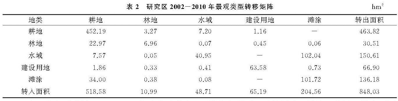
研究区2002—2010年由本景观向其他景观转化时占有率从小到大排序为:林地<建设用地<滩涂<水域<耕地,其中水域、建设用地、滩涂景观的转化率分别为17.76%,7.89%和16.06%。其中耕地转化率最大为54.69%,最小为林地,转化率为3.6%,具体见表2 。由其他景观类型向本景观转化时占有率排列顺序为:林地<水域<建设用地<滩涂<耕地,其中转化最大的依然是耕地61.15%,最小的是林地1.3%。可以看出,2002—2010年,广阳岛的土地用途几乎没有太大的变化,广阳岛景观类型转化较大的是主要分布在广阳岛四周的滩涂和水域,这主要是由于三峡库区蓄长江水位上升淹没了部分滩涂产生的变化。
表2 研究区2002-2010年景观类型转移矩阵hm2
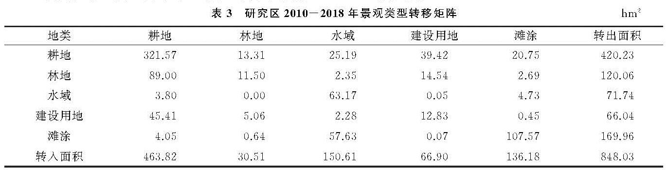
由表3 看出,广阳岛2010—2018年由本景观向其他景观转化时占有率从小到大排序为:建设用地<水域<林地<滩涂<耕地,其中水域、林地、滩涂景观的转化率分别为8.46%,14.16%和20.04%。其中耕地转化率最大为49.55%,最小为林地,转化率为7.79%。由其他景观类型向本景观转化时占有率排列顺序为:林地<建设用地<滩涂<水域<耕地,其中转化最大的依然是耕地54.695,最小的是林地3.6%。2010—2018年广阳岛景观类型转化分布范围较广,几乎整个岛域的景观类型都不同程度的发生了变化,这主要是由于岛上居民搬迁,使得岛上的土地用途发生了较大变化。
表3 研究区2010-2018年景观类型转移矩阵hm2
从景观类型转移变化空间分布图来看,广阳岛2002年、2010年、2018年景观类型变化极大,尤其是2010—2018年期间,景观类型发生了翻天覆地的变化。2002—2010年前期变化主要体现在水域景观和滩涂景观,空间分布主要在东北方长江一侧。2010—2018年后期景观类型变化主要是在建设用地与耕地、耕地与林地之间的变化,4种景观的变化面积较大,景观变化分布范围几乎遍及整个岛域。这主要是由于2010—2018年,岛上居民外迁,宅基地复垦变成耕地,广阳岛旅游业的发展使得交通和基础设施不断完善,部分耕地转变成建设用地。2002—2018年景观类型出现反复变化的区域主要是滩涂和水域,呈现环状分布,这主要是由于三峡库区蓄水和泥沙堆积沉积使得滩涂面积不断变化。
3.1.3 景观格局指数分析
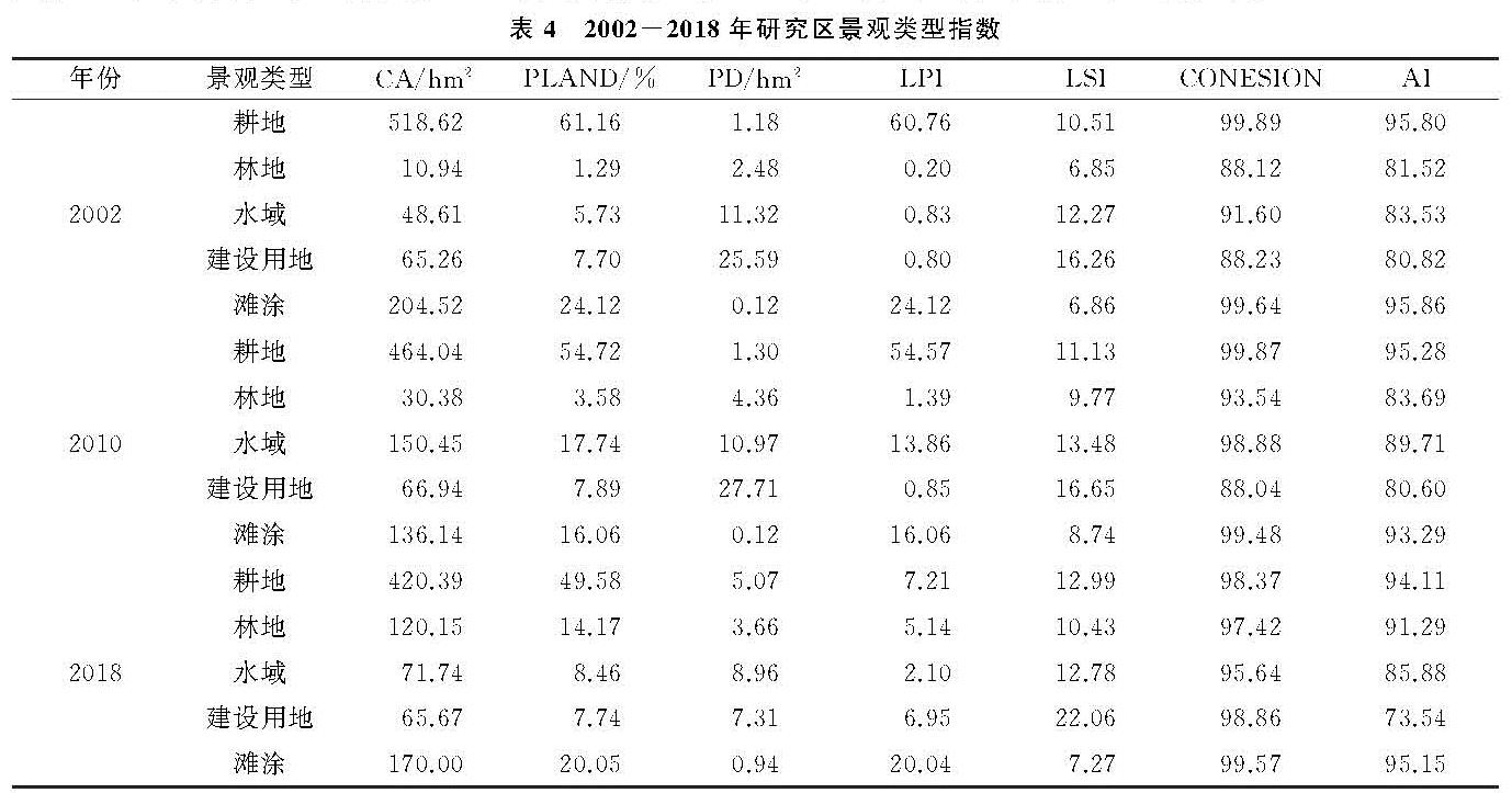
为了进一步分析研究区2002—2018年景观格局变化特征,从而挖掘出景观格局变化规律,文章对研究区各景观格局指数进行了分析,得到2002—2018年研究区景观类型指数表(表4 )。
2002—2018年研究区耕地和滩涂的斑块密度指数呈现不同程度的上升,水域的斑块密度呈现下降,林地、建设用地斑块密度出现波动。2002年耕地斑块密度为1.18,2010年为1.3,2018年为5.07,2002—2010年变化较小说明人为干预程度较低,2010—2018年斑块密度上升了3.89,增幅较大,表明人类活动将耕地分割成更多斑块,使得耕地景观更加破碎。2002—2018年滩涂斑块密度上升幅度为0.82,主要是由于三峡库区蓄水和泥沙沉积使得滩涂更加破碎。林地、建设用地斑块密度出现波动,林地主要是由于自然生长,人类干预少所以呈现波动,而建设用地则是居民搬迁建设用地的类型和空间位置发生了变化从而产生的波动。最大斑块指数(LPI)指各景观类型的最大斑块面积与景观总面积之比。在各景观类型中耕地的最大斑块指数最大,说明耕地在岛屿占有较大优势度,是岛屿的基质。景观形状指数(LSI)可度量斑块的复杂程度。研究区林地的景观形状指数最低,说明岛上林地的形状较不规则,其变化受人类干预较小,多为自然生长。建设用地景观形状指数最高,为22.06%,且呈现上升趋势,说明建设用地景观受人为干扰加剧,其景观形状受人类规划的影响大。耕地景观形状指数呈现上升趋势,说明人类干扰也加剧。水域、滩涂景观形状指数出现波动,但波动幅度小,主要是受自然条件的影响。斑块结合度指数(CONESION)指某一种斑块类型与其周围相邻斑块类型的空间连通程度。2002—2018年期间耕地、水域、滩涂土地的斑块结合度指数都在90%以上,部分年份甚至达到98%以上,说明这些景观类型具有高度的连通性。林地和建设用地斑块结合度呈现上升趋势,且上升幅度较大,表明人类对林地和建设用地的干扰程度较大,使得两者的贯通性大幅提高。聚集度指数指(AI)景观中不同斑块类型的非随机性或聚集程度,可反映出景观的空间配置特征。景观聚集度的值越小,说明景观的离散度越高,反之说明景观的离散度越低。2002—2018年,广阳岛耕地和滩涂景观聚集度指数都在90%以上,表明这耕地景观类型呈现较高的聚集状态,但是耕地景观聚集度呈现下降趋势,下降幅小于2%,滩涂景观聚集度指数呈现波动趋势,波动小于3%。建设用地聚集度最低,破碎化最严重,说明了人类对建设用地的干扰程度很大,建设用地聚集度指数从2002年80.82%下降到2018年73.54%,下降了7.28%。林地景观聚集度指数呈现上升趋势,从2002年81.52%上升到2018年91.29%,说明林地景观的人为干扰小,景观破碎度降低。水域景观聚集度指数在80%以上,波动幅度较大。建设用地景观聚集度指数呈现下降趋势,从2002年80.82%下降到2010年80.6%,再下降到2018年73.54%,2010—2018年期间下降幅度较大,表明2010年以来广阳岛建设用地景观变化较大。
3.2 地表特征参量时空特征分析
3.2.1 植被覆盖特征分析
总体来看,研究区的归一化植被覆盖指数出现了先上升后下降,2002—2018年期间广阳岛消落带的植被覆盖的到了极大提升,具体见附图6。具体来看:2002年广阳岛的植被覆盖西南侧较低,消落带的归一化植被覆盖指数低; 2010年广阳岛的植覆盖达到研究年限中最高状态,几乎除消落带外,整个岛屿都被植被覆盖; 2018年广阳岛的归一化植被覆盖指数出现下降,岛屿的植被主要集中岛屿的西北部和中部,四周的植被覆盖率低,这主要是由于对广阳岛的开发,环岛公路的修建和对环线四周进行了人为干预使得岛屿的归一化植被覆盖指数出现大幅度降低。2018年广阳岛的消落带归一化植被覆盖指数有的极大提高,整个岛域四周的消落带几乎都有不同程度的植被覆盖,这一切都应该归功于生态护岸工程的实施,使得消落带有了植被覆盖。通过三期的遥感影像对比发现,建设用地或者有人工干预过的区域其归一化植被覆盖指数大幅降低,建筑用地部分植被覆盖为零,这对岛屿的生态环境造成极大的影响,破坏了岛屿的生态平衡,使得岛屿的生态品质大幅度下降。如果对于岛屿消落带采取科学的生态措施进行人工干预,有利于促进岛屿消落带植被覆盖率的提高。
通过对研究区归一化植被覆盖指数变化的分析,可以得出以下结论:(1)研究区岛屿内陆部分的归一化植被覆盖指数出现了先上升,后下降的变化,消落带植被覆盖2002—2010年没有出现较大变化,但是2018年植被覆盖出现了大幅度的上升,说明采取科学、生态的手段对消落带进行干预能够有效的提高归一化植被覆盖指数;(2)2010—2018年人为干预较大的区域植被覆盖率出现大幅度的降低,这主要是有由于人为干预导致景观变化,植被覆盖率降低;(3)要尽可能的保持广阳岛原始的生态景观才能让研究区生态安全得到保证,同时也是对生态品质的保证。
3.2.2 地表温度分析
从附图7看,研究区2002年、2010年、2018年的地表温度发生了较大变化,其中2002年的地表温度是相对较高的一年,岛内的地表温度均呈现较高的态势,其在建设用地较为集聚的东北端和西南部出现了两个十分明显的高温区域; 2010年广阳岛整体温度是3个研究年限中最低的,且岛屿内的温度相对均匀,但在东北端依然存在一个明显的高温点,这更加验证了建设用地对岛屿局部温度的影响较大。2018年广阳岛的地表温度分布出现了较大的差异,岛屿内温差较大,且南北两侧温差十分明显。从2018年广阳岛地表温度图上可以看到,环岛公路右侧到消落带的区域温度明显较其他区域高,该区域是认为对景观格局干预最多,也是景观变化最大的区域,在环高公路的周边还出现了呈现条带状的高温区域。
人为对土地景观的干扰会对区域的地表温度产生明显的影响,尤其是建设用地会大幅度的提高局部温度,形成高温点。同时,局部高温不仅仅是对高温区域会产生影响,还会对周围想邻的区域产生附带影响。由此可见人为干预对岛屿生态质量的影响较大,必须要重视人为活动对生态环境造成的破坏,尤其要重点关注建设用地对岛屿生态安全和生态品质造成的恶劣影响。
3.2.3 土壤湿度分析
土壤湿度是生态效应的一个重要指标。由附图8可见,2002—2018年广阳岛土壤湿度出现了极大的变化,具体来看,2002年广阳岛土壤湿度分布较为均匀,但是消落带的土壤湿度较低,这可能是由于消落带没有植被覆盖土壤的保湿能力差、蒸发快所以其土壤湿度低。同时,岛屿内部建设用地部分土壤湿度几乎为零。2010年广阳岛土壤湿度分布也较均匀,岛屿内部没有出现较大的差异,消落带的土壤湿度很低。2018年广阳岛土壤湿度在空间和数量上的差异变化较大,广阳岛东北部和南部的土壤湿度很低,这些地方均是人类活动对广阳岛景观格局进行干扰了的区域,所以导致土壤湿度下降变得很低。广阳岛西南部没有人为干扰的区域,其土壤湿度较高,可以明显看出其与人为干预区域的湿度差异。2018年广阳岛消落带的湿度也出现了很大的变化,由2002年、2010年湿度极低,演变成湿度相对较高的区域,这主要是由于广阳岛生态护岸工程的开展使得消落带的归一化植被覆盖指数提高,土壤湿度也响应提高。
3.3 地表特征参量对景观格局变化响应分析
3.3.1 植被覆盖对景观格局响应
为了更加详细对比2018年研究区归一化植被覆盖指数在空间分布上的差异,将景观类型图与归一化植被覆盖指数等值线图进行叠加得到附图9,通过分析,研究区归一化植被覆盖指数从消落带到岛屿中心的分布规律是消落带部分植被覆盖度较高,然后消落带到环岛的内部公路的植被覆盖明显降低,再到岛屿中部高地其植被覆盖率再次上升。整个覆盖率从0.4~0.7,下降到0.3~0.5,再上升到中部的0.6~0.7,呈现明显的先高再低再高的空间规律。研究区建设用地景观的归一化植被覆盖指数极低,主要是由于建设用地周围的植被覆盖用地的作用。人为人工绿地的值主要集中在0.3~0.4,部分地方植被覆盖指数达到了0.5,自然绿地的归一化植被覆盖指数主要在0.6~0.7,其植被覆盖整体分布都很均匀,没有出现异常值,是所有景观类型中平均植被覆盖率最高,分布最均匀的。消落带的植被覆盖率南部和北部的差异较大,东岸和西岸的差异较大,消落带植被覆盖较高的部分植被覆盖指数值大致在0.5~0.7,有部分区域归一化植被覆盖指数达到了0.8~0.9,这部分区域是整个岛域中归一化植被覆盖指数最高的。消落带中植被覆盖低的区域主要是由于江水经常淹没的原因。
3.3.2 地表温度对景观格局响应
地表温度的变化与景观类型相关性极大,岛屿内建设用地部分的地表温度最高,从2010—2018年研究区地表温度变化图可以明显看出环岛公路的地表温度有加大幅度的升高。同时,还可以看到对土地进行了推平或者其他较大人为干预的区域,地表温度也相对较高。但是随着对这些敏感景观距离的增加,地表温度也逐渐降低。这些变化充分说明了人为破坏原始景观对广阳岛的生态造成极大的影响,尤其是在岛上进行建设开发会导致广阳岛生态效应降低。
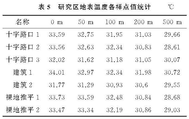
为了深入分析景观改变对地表温度的具体影响,本研究选择了3种景观类型的7个试验点,进行了地表温度的缓冲分析。结合表5 可知,随着缓冲距离的不断增加各样点的地表温度逐渐降低,这与地表温度随着距敏感区的距离越来越远,地表温度也逐渐降低的猜测相吻合。以建筑物1体育训练场为例做深入分析,该建设用地点中心温度为34.01℃,当缓冲距离为50 m时,其地表温度为32.97℃,下降了1.04℃; 随着缓冲距离的增加,当缓冲距离为100 m时,地表温度为32.34℃,地表温度下降了0.63℃,地表温度下降的幅度减小; 当缓冲距离为200 m时,地表温度为31.98℃,地表温度下降0.36℃,地表温度下降的幅度再次减小; 当缓冲距离为500 m时,地表温度下降到30.72℃,下降了1.26℃。由此可以看出,地表温度与缓冲距离呈现负相关关系,随着缓冲距离的增加,地表温度也逐渐降低。
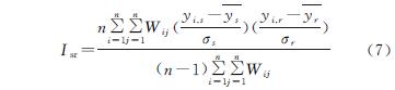
3.3.3 空间相关性分析 文章采用了空间相关性分析模型,对研究区景观格局指数和地表参量的空间关联特征进行了相关性分析,获得
表6 所示结果。
对研究区2002—2018年的景观格局指数与地表参量进行相关性分析,研究区景观格局变化状况与植被覆盖指数呈正相关的区域面积占总面积的96.56%,显示出植被状况与景观格局具有相当高的相关性。二者负相关的面积仅占总面积的3.44%,主要分布在滩涂和消落带地区。植被覆盖指数与地表温度的显著性也较显著,二者负相关性达到显著水平,占整个研究区面积的73.22%。呈正相关关系区域基本没有达到显著水平。植被覆盖指数与土壤湿度的显著性比较显著,二者的正相关性达到显著水平,占整个研究区面积的78.62%。呈负相关关系区域基本没有达到显著水平。
4 讨论与结论
4.1 讨 论
人为干预对景观的改造给区域生态环境带来了巨大的冲击。对岛屿高强度的开发推动了经济发展的同时,也改变了区域生态安全格局,构成了生态脆弱地区的景观格局与区域的生态安全的矛盾与冲突[16-19] 。
首先,研究区归一化植被覆盖指数呈现先上升,后下降的变化,2002年、2010年归一化植被覆盖指数的数值在空间上分布较均匀,2018年的高归一化植被覆盖指数呈现环状分布,外围高中部低,中心高的分布。没有人为干预的植被覆盖最高,分布也最均匀,说明其生态稳定,生态效应好。人为干预对景观的干预是植被覆盖变化的主要原因,人为干预的程度越大,植被覆盖越低,维护原始景观是最有效的生态保护措施。
其次,地表温度与景观类型有着密切的关系,人为干预对土地景观类型的改变会对该区域地表温度产生较大的影响,且人为干预程度的高低也对温度的高低有不同的影响,干预程度越高地表温度高。建设用地对地表温度的影响很大,是研究分类的景观类型中地表温度最高的景观,说明建设用地对地表温度的影响最大。敏感区的地表温度与缓冲区呈现正相关关系,随着缓冲距离的增加,其地表温度也随之降低。要坚决减少广阳岛上的建设用地,控制建设用地规模,尽可能的保护广阳岛的原始生态景观,对广阳岛的生态安全和生态品质有着举足轻重的作用。广阳岛内部土壤湿度与人为活动密切呈现负相关,人为对岛屿原始景观的改变程度越大,其土壤湿度也就越低。广阳岛环岛消落带的土壤湿度与人为活动呈现明显的正相关,如果采取科学、生态的手段对消落带进行治理,能够有效的提高消落带区域的土壤湿度。修建建设用地对土壤湿度的破坏极大,要尽可能的减少广阳岛的建设用地范围,保持广阳岛原始的生态景观的生态质量。
最后,从景观格局演变过程和地表特征参量的演变特征来看,两者的变化表现出较高的重叠度。具体表现为:在时间尺度上,2002—2018年研究区景观格局和地表特征参量均出现较大变化。建设用地的扩张,高植被覆盖区域和高湿度区域面积的减少、高地表温度区域面积的增加是该时段广阳岛整体用地变化的显著特征。在空间格局上,新增建设用地区域的地表温度和土壤湿度的改变在空间上表现出高度的一致性。两者变化特征的一致性,进一步表明景观格局与地表特征参量的变化间存在紧密联系。
4.2 结 论
(1)2002—2018年,研究区各类景观的空间分布很不均衡,其中耕地分布的范围最广、面积最大,是岛屿景观基质; 林地主要分布在岛屿中部; 水域主要分布于东北部和北部; 建设用地主要是公路,呈现环状分布,多分布于南部; 滩涂主要分布西部和西北部,且围绕岛屿呈现环状分布。
(2)研究区景观破碎度呈现先稳定后明显升高趋势,景观整体趋不稳定。滩涂是广阳岛的一类特殊景观,在水源涵养、水土保持、生物多样性保护等方面其中重要作用。要注重滩涂的有效保护和合理利用,维持景观稳定性。
(3)研究区的植被覆盖呈现出先上升后下降的变化特征,消落带的植被覆盖有较大的提升,但整体有所下降,需要尽量维持广阳岛原始的生态景观,提升生态品质。
(4)研究区地表温度呈现上升趋势,特别是新增建设用地区域; 消落带土壤湿度较低,建设用地区域土壤湿度几乎为零。2010—2018年,广阳岛土壤湿度在空间和数量上存在较大差异,具体为东北部和南部较低,西南部较高,且表现出明显的人为干预差异。
(5)区域地表特征参量对景观格局的变化有着十分密切的响应关系,景观格局的变化是自然因素和人类活动共同作用的结果,相比自然因素,人为干预对广阳岛景观格局变化起着更为重要的作用。
表2 研究区2002-2010年景观类型转移矩阵hm2 表3 研究区2010-2018年景观类型转移矩阵hm2
[1] 燕守广,李辉,李海东,等.基于土地利用与景观格局的生态保护红线生态系统健康评价方法:以南京市为例 [J].自然资源学报,2020,35(5):1109-1118.
[2] 付扬军,师学义,和娟.汾河流域景观格局脆弱性时空分异特征 [J].水土保持研究,2020,27(3):197-202.
[3] 王琦,王晓娜,牟惟勇,等.黄石市土地利用景观格局变化研究 [J].中国农学通报,2019,35(9):81-85.
[4] 陈芝聪,谢小平,白毛伟.南四湖湿地景观空间格局动态演变 [J].应用生态学报,2016,27(10):3316-3324.
[5] 满苏尔,沙比提.新疆南疆地区土地利用变化及其生态效应 [J].地理科学,2011,31(4):440-446.
[6] 王越.松嫩高平原土地利用格局变化机理及其优化模式研究 [D].沈阳:东北大学,2017.
[7] 井云清,张飞,陈丽华,等.艾比湖湿地土地利用/覆被—景观格局和气候变化的生态环境效应研究 [J].环境科学学报,2017,37(9):3590-3601.
[8] Shan W, Jin X, Ren J, et al. Ecological environment quality assessment based on remote sensing data for land consolidation [J]. Journal of Cleaner Production, 2019,239:118-126.
[9] 奚世军,安裕伦,李阳兵,等.基于景观格局的喀斯特山区流域生态风险评估:以贵州省乌江流域为例 [J].长江流域资源与环境,2019,28(3):712-721.
[10] 冯源嵩.贵阳市核心区景观格局演变的水环境效应研究 [D].重庆:西南大学,2016.
[11] 王福海.特大山地城市建设用地扩展及其遥感地表特征参量响应研究 [D].重庆:重庆工商大学,2015.
[12] 杨乐.山地城市空间扩展及其生态效应研究 [D].重庆:西南大学,2011.
[13] 刘小平,黎夏,陈逸敏,等.景观扩张指数及其在城市扩展分析中的应用 [J].地理学报,2009,64(12):1430-1438.
[14] 原菲菲,徐增让,詹卫华,等.不同土地利用类型的地表特征参量的遥感反演研究:以猫跳河流域为例 [J].长江流域资源与环境,2013,22(6):721-728.
[15] 谢元礼,范熙伟,韩涛,等.基于TM影像的兰州市地表温度反演及城市热岛效应分析 [J].干旱区资源与环境,2011,25(9):172-175.
[16] 李冬杰,杨利,余俞寒,等.都市生态旅游区土地利用碎片化对生态系统服务价值的影响:以武汉东湖生态旅游区为例 [J].生态学报,2019,39(13):4782-4792.
[17] 张天海,田野,徐舒,等.滨海城市土地利用格局演变及对生态系统服务价值的影响 [J].生态学报,2018,38(21):7572-7581.
[18] 南箔,杨子寒,毕旭,等.生态系统服务价值与人类活动的时空关联分析:以长江中游华阳河湖群地区为例 [J].中国环境科学,2018,38(9):3531-3541.
[19] 苟睿坤,赵选,卜元坤,等.杭州市城区热岛效应与景观格局的动态研究 [J].水土保持研究,2019,26(1):316-322.