3.1 耕地细碎化基本特征
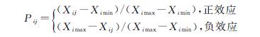
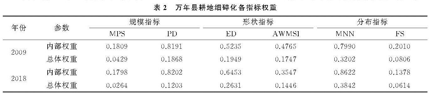
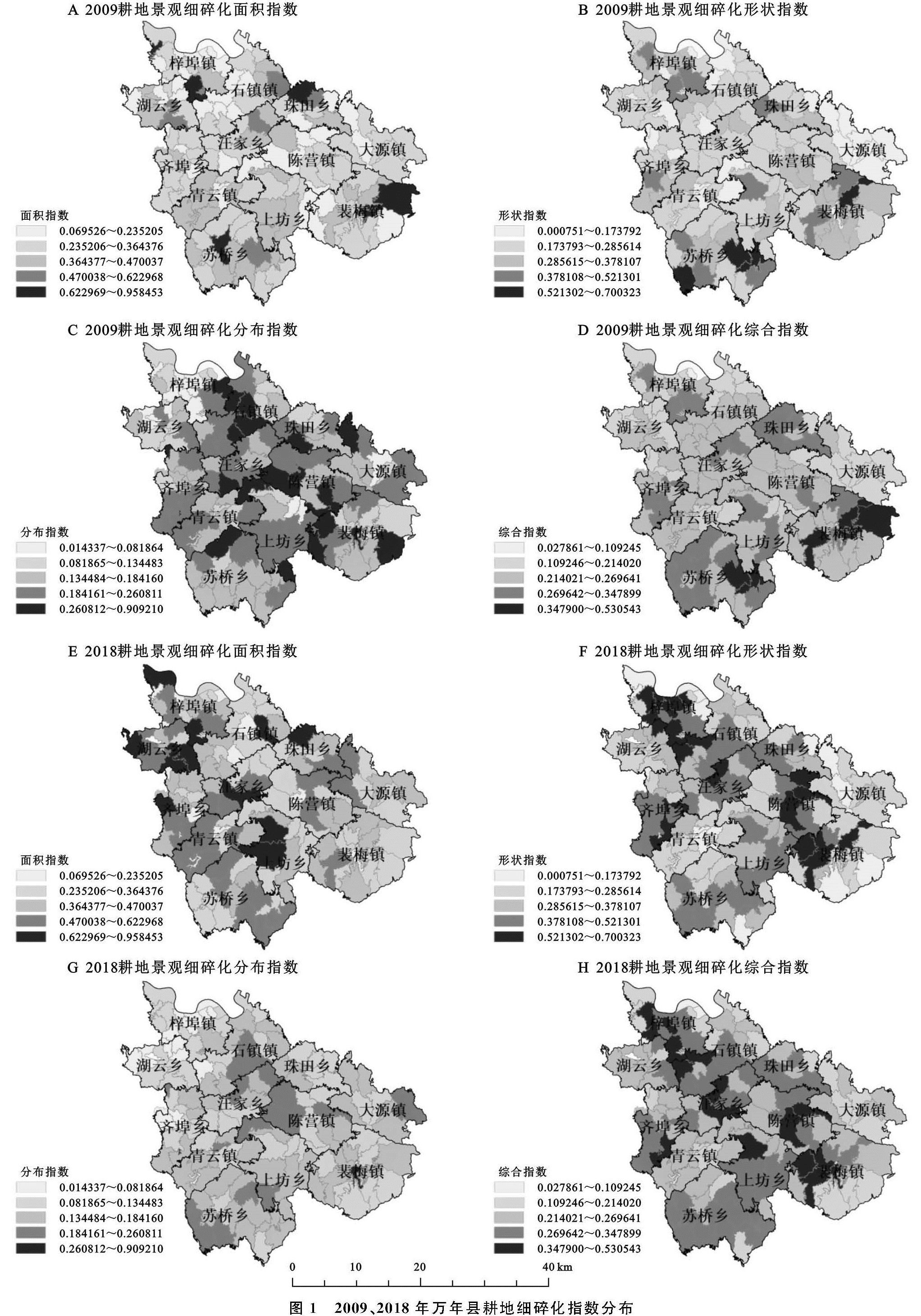
根据选取的测算指标分别对万年县2009年与2018年各行政村的耕地进行面积指数、形状指数、分布指数以及综合指数的测算,按照Jenks自然断点法将细碎化级别分为五级,级数高表明细碎化越严重。根据测算及分级结果输出万年县耕地细碎化各级行政村数量、耕地面积及占比情况表(表3)及万年县2009—2018年万年县耕地细碎化指数分布图(图1)。从耕地细碎化综合指数来看,9 a间万年县耕地细碎化程度明显加剧。2009年,细碎化级别为3级的耕地占比最高,涉及62个村庄,占全域所有耕地面积的46.54%,空间上表现出连片分布; 2018年,细碎化4,5级耕地增长明显,分别比2009年增加了2 471.44 hm2,3 307.81 hm2。
表3 2009年、2018年万年县各级耕地细碎化行政村数量、耕地面积及占比情况
图1 2009、2018年万年县耕地细碎化指数分布
3.1.1 耕地面积指数空间分异 通过选取平均地块面积(MPS)、斑块密度(PD)两个景观格局指数来表征耕地在规模上的破碎程度,计算得出万年县2009—2018年各行政村耕地面积指数空间分布情况,该指数越大表明该村耕地在规模上越细碎。在面积指数层面,2009年万年县耕地占比最高的为2级细碎化耕地,占全域耕地总面积的41.69%,96个村的耕地为1~2级细碎化,表明2009年万年县耕地平均地块面积较大,在规模上具有一定的连片性,人为占用程度较低。在空间分布上,万年县东南部以及石镇镇与珠田乡相接地带耕地平均规模相对较小,主要是因为这两处区域地势相对较高,且坡度较大,耕地受地形割裂呈现出耕地平均斑块面积小、斑块密度高的特征。2018年细碎化1~2级耕地显著减少,3~5级耕地占比均有所提高,其中细碎化4级耕地增长最为显著,由2008年4.65%增长至29.13%成为占比最高区间。面积细碎指数在空间分布上也呈现出一定的集聚特征,细碎化较为严重的耕地主要分布在西北部湖云乡、梓埠镇一带。
3.1.2 耕地形状指数空间分异 边界密度指数(ED)、面积加权形状指数(AWMSI)共同表征各行政村耕地形状的细碎程度。2009年万年县耕地形状细碎化指数整体呈低水平,细碎化2级耕地占比最高,1~2级耕地共占比59.18%,仅有4个村庄细碎化级别达到了5级。这是由于2009年万年县还是以农业生产为主,田坎及灌溉设施使耕地边界较为平直,形状较为规则。2018年由于万年县大力发展黑猪养殖、珍珠培育、大棚蔬菜以及劳动密集型工业,使得劳动力大规模转移,其他产业占用耕地生产,一定程度上破坏了耕地斑块形状,使得耕地细碎化形状指数明显上升,1~3级耕地面积均减少,4级耕地成为占比最高区间,4,5级耕地占比分别增加13.9%,15.2%,细碎化5级耕地主要分布在梓埠镇、陈营镇以及裴梅镇。
3.1.3 耕地分布指数空间分异 平均最邻近距离(MNN)及破碎化指数(FS)综合测算得出万年县耕地细碎化分布指数,通过两个年份对比,分布指数演变趋势明显不同于综合指数以及形状、面积指数。2009年分布指数主要集中在3~4级,占比63.51%,而2018年2级耕地占比增长显著,增长26.58%,4~5级占比明显减少。从熵值法确定的指标内部权重来看,平均最邻近距离权重较大,2009年耕地分布指数较高表明当年耕地分布比较离散,而2018年耕地分布趋于集中,这表明城镇化进程的推进影响了耕地的分布情况,其他产业对耕地的占用使得耕地面积缩减,机械化水平的提升也在一定程度上推动了耕地的集聚。
3.2 耕地细碎化驱动因子贡献力分析
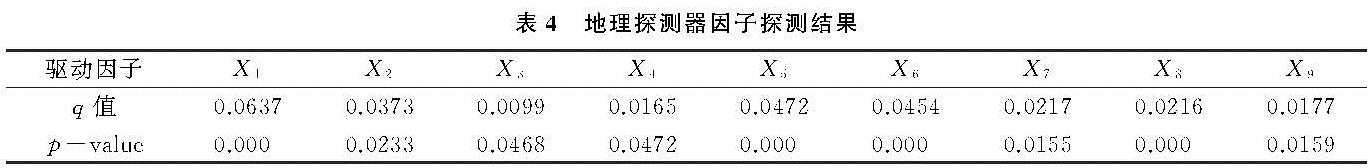
利用地理探测器测算方法,选取高程(X1)、坡度(X2)、坡向(X3)、距河流距离(X4)、乡镇人口密度(X5)、距农村居民点距离(X6)、距公路距离(X7)、距铁路距离(X8)以及距乡镇行政中心距离(X9)9个探测因子,计算2018年各探测因子对万年县耕地细碎化的影响能力,q值越大意味着该探测因子对耕地细碎化的贡献力越大。从综合指标探测结果来看,耕地细碎化主要驱动因素依次是高程、乡镇人口密度、距农村居民点距离以及坡度(表4)。
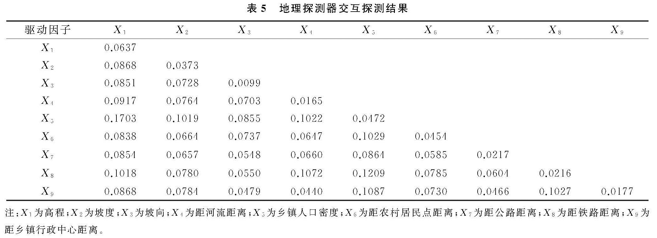
地理探测器交互探测可识别不同风险因子Xi之间的交互作用,即评估因子X1和X2共同作用时是否会增加或减弱对因变量的解释力,或这些因子对因变量的影响是否为相互独立的,两个因子之间的关系可分为非线性减弱、单因子非线性减弱、双因子增强、独立以及非线性增强5类[27]。万年县耕地细碎化驱动因子交互探测结果见表5。结果表明各探测因子对耕地细碎化的影响不是独立的,任何两种因子交互作用对耕地细碎化的影响都大于单一因子贡献力,因素之间呈相互增强或非线性增强效应。
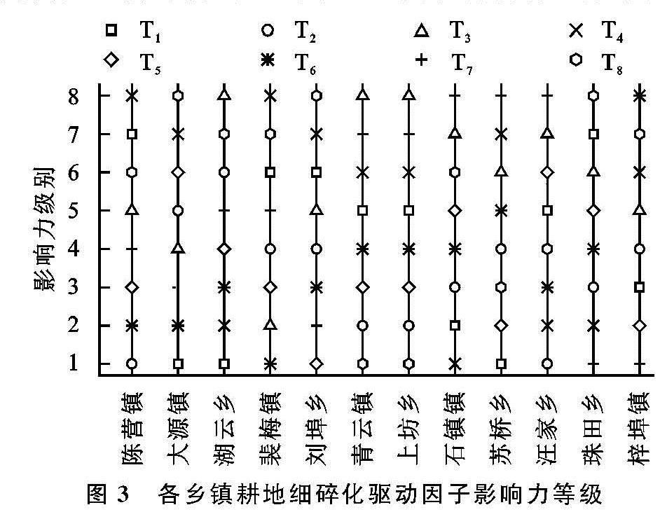
3.3 耕地细碎化乡镇尺度空间分异驱动因子分析
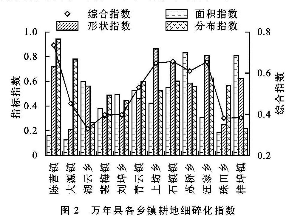
因各县镇资源禀赋和区位条件具有明显差异,根据万年县城市总体规划,依据不同乡镇的主导产业以及乡镇发展定位,将万年县12个乡镇分为综合发展型、工业贸易型、生态旅游型以及农业生产型4类。因乡镇人口密度在评价单元(乡镇)中无变异,且次级样本区(行政村)人口密度数据难以获取,因此将乡镇人口密度因子剔除,利用高程(T1)、坡度(T2)、坡向(T3)、距河流距离(T4)、距农村居民点距离(T5)、距公路距离(T6)、距铁路距离(T7)以及距乡镇行政中心距离(T8)8个探测因子对各乡镇耕地细碎化主要驱动因素进行探测。各乡镇耕地细碎化指数见图2,驱动力探测结果见图3,为更加直观体现各探测因子的驱动力,按照地理探测器求出的q值将各因子贡献力程度进行排序赋予等级,其中8级表示该因子影响力最大,1级因子影响力最小。
作为万年县中心城区的陈营镇与上坊乡,其耕地都处于高度细碎化状态。陈营镇的细碎化综合指数居全县之首,其中分布指数最高。陈营镇耕地细碎化主要影响因子为距河流距离、高程、距乡镇中心距离以及距公路距离,自然地理条件以及社会经济条件对该镇都表现出了较强的影响力。陈营镇三面环山,且珠溪河从镇内穿过,自然地理条件在一定程度上使得耕地表现出细碎化; 社会经济因素层面,陈营镇是万年县中心城区,为综合发展型城镇,是县域政治、经济、文化中心,路网密集,城镇化水平高,高密度、多类型的城市要素侵入使得耕地面积减少,原本大面积连片的耕地被当地密布的交通路网割破。上坊乡作为另一中心城区,也表现出较高的综合细碎化指数,距乡镇中心距离、距公路距离的贡献力明显,城镇中心人口高度集聚、城郊工业园区不断扩张都直接导致耕地细碎化程度加剧。
石镇镇为万年县凤巢工业园区分布区,是典型的工业贸易型乡镇。探测因子主要贡献程度依次表现为距乡镇行政中心距离、距铁路距离、距公路距离、距农村居民点距离等,细碎化综合指数仅次于陈营镇。这与当地主要发展新能源、精细化工、汽配等工业有关,工业园区布局受交通干线影响,耕地被用于工业用地和交通线路侵占、分割,对耕地形状指数影响明显。
生态旅游型乡镇大源镇与裴梅镇分别以“稻源特色”和“贡米特色”建设特色旅游型小镇,依托境内神农源风景名胜区和珠溪河国家湿地公园大力发展旅游业。二者都位于万年县东南部,地势高、坡度大,整治细碎耕地成本高; 同时,县镇中心以及城郊的观光、住宿基础设施的建设使得距乡镇行政中心的距离成为影响耕地细碎化的主要因素。由于两县均位于生态保护区,生态保护红线的限制使得人为扰动程度低于中心城镇,耕地景观细碎化程度低。
农业生产型乡镇虽都以农业作为当地主导产业,但由于农产品类型不同,耕地细碎化程度出现分异。苏桥乡主要以种植葡萄、油茶等农作物为主,汪家乡以培育无籽西瓜、花卉苗木、蔬菜种植和生猪养殖为主,两个乡镇虽为农业生产型乡镇,细碎化指数却都在0.6以上,这是由于畜禽养殖、工厂化作物栽培以及水产养殖造成设施农用地大面积侵占耕地,造成耕地细碎化加剧,且劳动密集型农业吸引了大量劳动力,耕地不断被边际化,导致细碎化程度加剧。探测因子中,自然因子对苏桥乡、汪家乡耕地细碎化影响显著,万年河流经苏桥乡,且境内分布着许多水库,河网密布制约着耕地景观连片性; 汪家乡整体地势为东南高西北低,高程差距较大,直接影响着耕地分布。
其他各乡镇则以传统粮食作物生产为主,耕地细碎化程度相对较低。齐埠乡、湖云乡和梓埠镇位于万年县西北部,地处鄱阳湖平原,地势优势以及传统农业生产为主的产业构成使得三各乡镇整体耕地细碎化指数处于较低水平。3个乡镇位于玉津河与乐安河相接处,河网密布,因而距河流距离对3个乡镇影响显著。青云镇虽也为传统农业生产型乡镇,但作为万年县老县城,拥有一定的交通优势,且境内有万年河途经,因此,距公路距离与距河流距离对当地耕地细碎化影响程度较高。
地域性的自然环境、经济社会发展程度导致各乡镇的驱动因素差异明显。综合来看,经济发达的综合型中心城镇耕地细碎化程度高,受距县镇行政中心距离、交通要素影响显著。工业贸易型乡镇对物流成本要求较高,因而距公路距离对此类乡镇的耕地细碎化表现出明显的决定力。生态旅游型乡镇由于自然地理条件与发展服务业的产业导向,耕地形态与高程、坡度等自然条件,以及乡镇中心旅游业基础设施的建造联系密切。农业生产型乡镇耕地细碎化程度与其生产的农产品种类有一定联系,对于畜禽养殖、工厂化作物栽培以及水产养殖等对人工生产条件需求较高的地区,耕地细碎化指数较高; 主要生产粮食作物的乡镇社会发展程度较为落后,综合细碎化指数水平低,社会经济因素影响力小,主要影响因子则表现为距河流距离、高程等自然地理因素。