3.1 讨 论
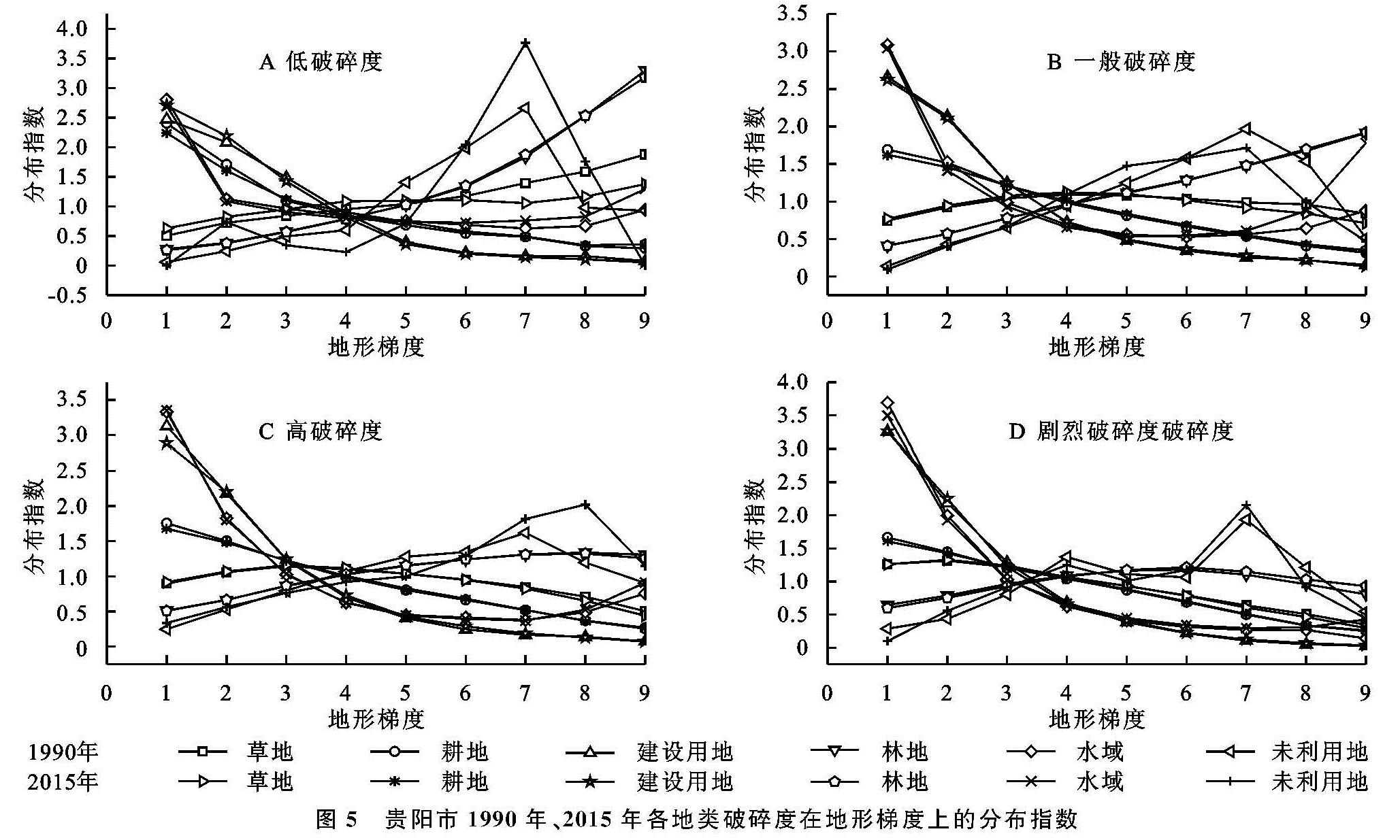
(1)基于地形梯度的破碎度一般规律。研究区存在着各种自然和人文的差异,通过对不同梯度上地类的破碎度及其分布指数进行统计分析,发现存在区域差异性的同时,也存在着一些共同的分布特征(图5)。
4个破碎度等级中,1990年和2015年建设用地均在1~3梯度内表现为优势分布,且均随着梯度增加而分布指数减小。1990年耕地从低破碎度到剧烈破碎度等级时,均在1~3梯度表现为优势分布,2015年除低破碎度外,耕地的其他破碎类型优势分布扩大到了第4梯度,说明贵阳市耕地分布有向中高地形位变化的趋势,与魏小芳等[32]研究结论相同。总体而言,贵阳市耕地和建设用地及水域的4种破碎度,在1~3地形梯度内均为优势分布,且随着地形位的升高,分布指数逐渐趋近于0。草地和林地在中高地形位分布面积最广。未利用地在高地形位具有优势。
(2)喀斯特山区景观破碎影响因素。山区景观破碎是社会经济和政府政策及自然因素综合作用的结果[33]。坡度高程等自然因素决定土地利用类型的空间分布格局,也是景观破碎的基底[34],贵阳市破碎度具有显著的地形梯度特征。受地形影响,人类经济活动主要集中在坡度和海拔较小的区域,而高海拔高坡度大地区活动不频繁,形成建设用地、水域和耕地破碎主要集中于人类活动密切的地形位较低区域; 林地和草地破碎则分布在地形位较大位置,且林地表现出地形位越大,其破碎化越向低破碎度靠拢的趋势。社会经济涵盖城镇化、经济、交通建设和生活高质量追求等,是景观破碎的内在动力[24]。贵阳市经济和城市化发展的集聚效应,诱使人们为增加经济收入而远离农村,推动城市不断扩张,使得建设用地和耕地破碎度低和一般等级的分布范围逐渐向中地形位区间拓展[35]。同时贵阳市是西南地区铁路和公路交通枢纽中心,近年来县县通高速和村村通公路的建设,耕地、林地和草地等被切割分化,图斑面积减小。此外,人们对生活质量的追求不断上升,城市草地、林地和公园绿地面积攀升,迫使低地形位草地和林地的高破碎和剧烈破碎分布指数逐渐扩大。政策方面受退耕还林和精准扶贫等影响,大于25度耕地实行严格退耕,贵阳市地处高海拔、坡度大的区域,在人为政策活动干预下已经出现了向森林和草地及未利用地转型的现象[23]。
图5 贵阳市1990年、2015年各地类破碎度在地形梯度上的分布指数
(3)研究特色及不足。研究景观破碎化的成果颇丰,但已有对景观破碎的研究,只是简单指出其空间分布,没有对破碎进行分级研究,更缺乏对景观破碎地形梯度方面的探究。本文特色之处在于将景观破碎与地形梯度联系起来,指出了各景观破碎度在各地形位上的分布特征。不足之处在于对景观破碎演化因素只是简单的从定性方面进行阐述,而没有进行定量的探究,对地形梯度上景观破碎度演化因素定量研究是下一步研究的重点。
3.2 结 论
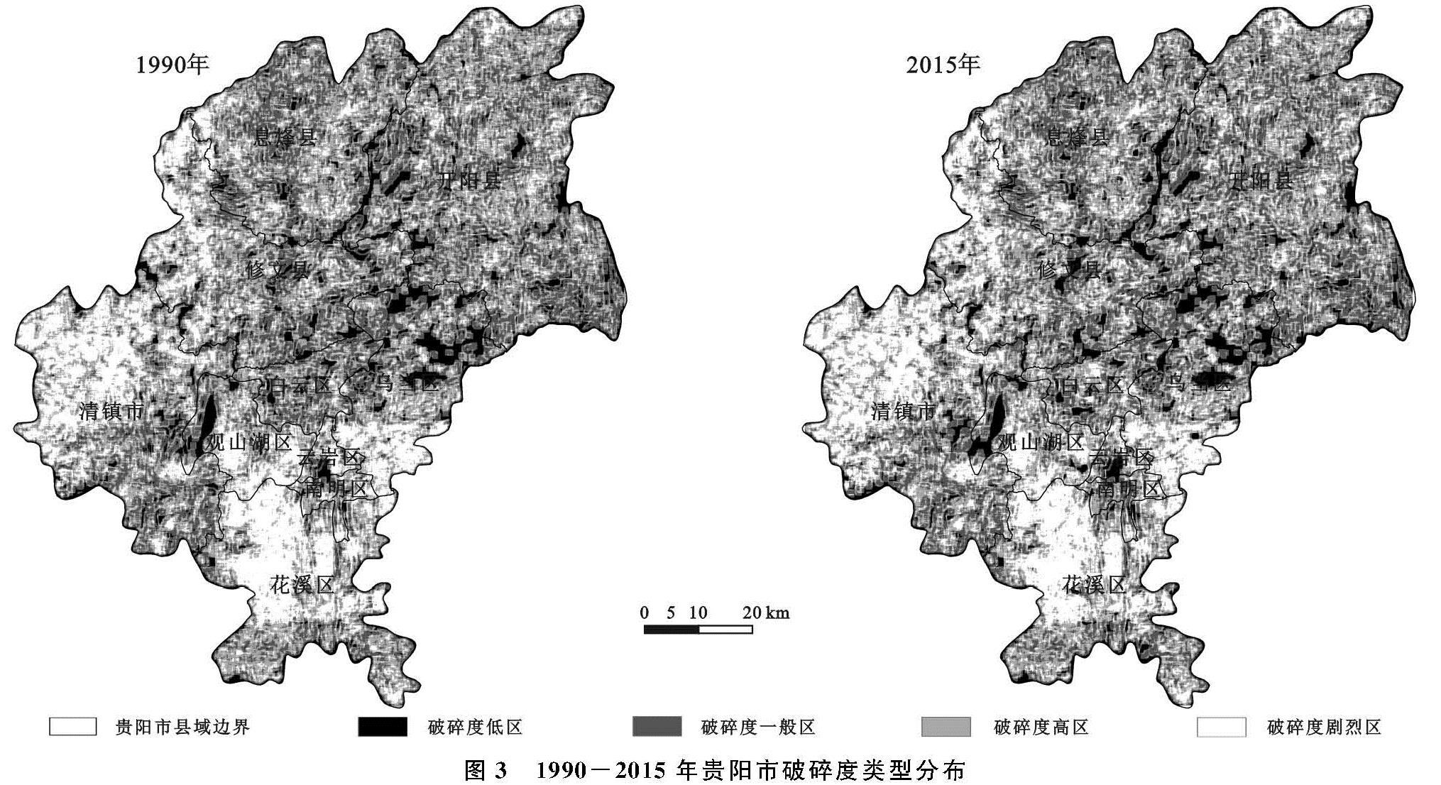
贵阳市1990—2015年以高破碎和一般破碎度为主。1990年占比达42.51%和30.36%,2015年为41.33%和30.56%,且高破碎面积减少94.01 km2,其余3种破碎度类型略有增加。25 a间,高破碎度有所减少,其余3种类型略有增加。高和剧烈破碎度类型主要集中于研究区的西部和南部地域,而北部则相对较少; 低破碎度和一般景观破碎度在贵阳市中部、北部和东部区域较为密集。
贵阳市各景观破碎有显著的地形梯度分异效应。1990—2015年耕地和水域及建设用地与地形位呈负相关关系,在1~2梯度内均为优势分布,且在剧烈破碎度时,耕地的地形梯度特征没有建设用地和水域明显; 两期低破碎林草地与地形梯度成正相关,在5~9梯度为优势分布,而剧烈破碎的林草地随地形位增加而减小,地形位高的区域以林草地为主。未利用地与地形梯度均呈现先增加后减小的趋势,且在7~8梯度时优势分布达到最大值。