3.1 土地利用类型时间变化分析
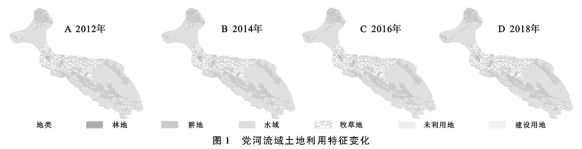
党河流域2012—2018年林地、耕地、牧草地、水域、未利用地、建设用地变化见图1。各类土地面积占比大小分别为未利用地、牧草地、水域、林地、耕地以及建设用地,平均占比分别为52.66%,24.32%,11.36%,9.38%,1.84%,0.44%。未利用土地占比最高,建设用地占比最少。这种土地类型的分配与当地的气候特征有着直接的关系。
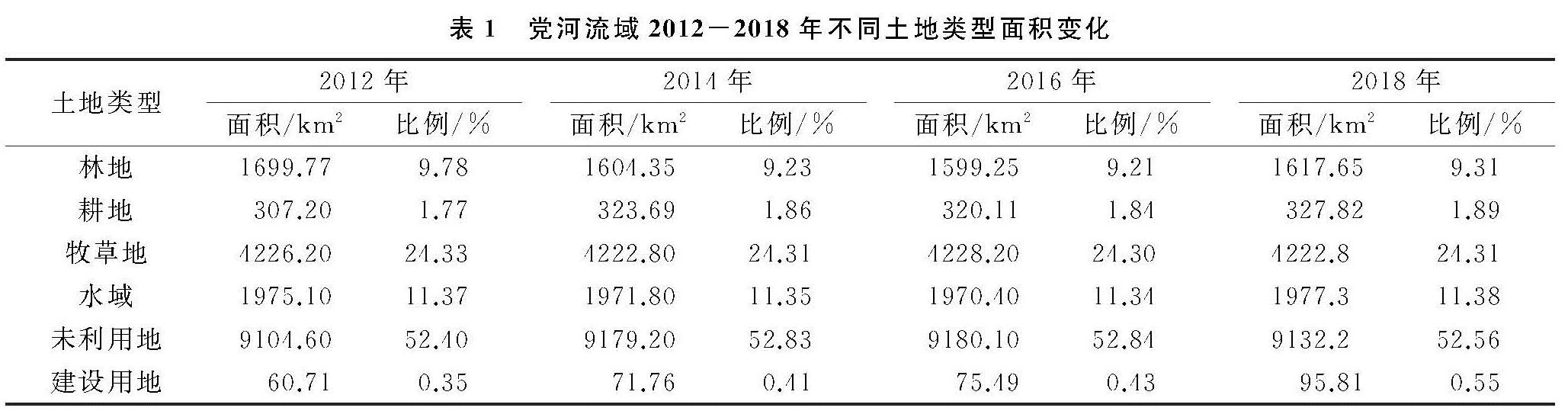
从各类土地类型总占比变化情况来看(表1),2012—2018年中,林地总占比减少量最大,为0.47%(82.13 km2),建设用地总占比增加量最大,为0.20%(35.10 km2)。牧草地总占比减少量0.02%(0.63 km2),耕地、水域、未利用地均有所增加,增加量分别为0.12%(20.62 km2),0.01%(2.16 km2),0.16%(27.61 km2)。
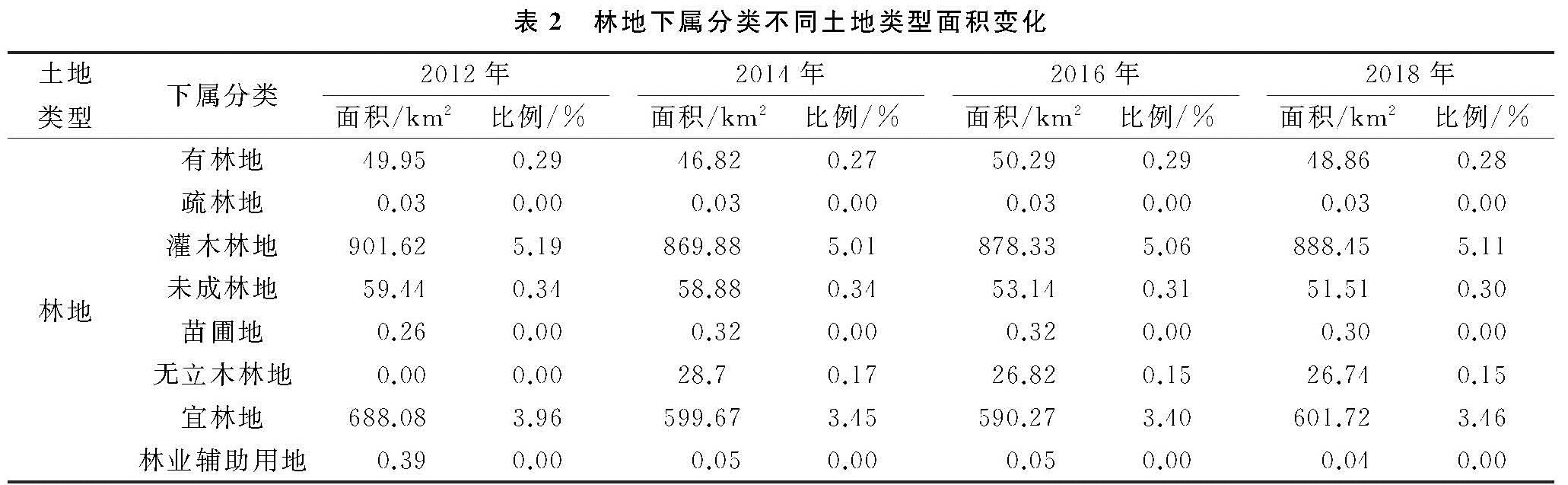
从各类土地在6 a间的环比变化来看:(1)林地面积2012—2014减少了5.61%,2014—2016年减少了0.32%,2016—2018年增加了1.15%。2012—2018年林地面积共减少了4.83%。在林地的下属分类中(表2),6 a间灌木林地和宜林地面积均占据主导地位,相对于林地总面积的平均占比分别为54.26%与38.03%,此类林地面积较广与当地的气候特征有直接关系。6 a间灌木林地和宜林地分别减少了1.46%(13.17 km2)以及12.55%(86.36 km2)。宜林地的大幅减少是林地面积减少的主要贡献源。林地其他下属分类中,6 a间有林地、疏林地、未成林地、苗圃地、无立木林地占林地总面积比值较小,平均占比分别为3.00%,0.00%,3.42%,0.02%,1.26%。林业辅助用地面积减少量明显,2012—2018年减少了90.91%。(2)耕地面积2012—2014年增加了5.37%,2014—2016年减少了1.11%,2016—2018年增加了2.41%。2012—2018年耕地面积增加了6.71%。(3)牧草地6 a间减少了0.08%,水域减少0.11%。(4)未利用地面积2012—2014年增加了0.82%,2014—2016年增加了0.01%,2016—2018年减少了0.52%。2012—2018年的6 a间增加了0.30%。(5)建设用地面积2012—2014年增加了18.19%,2014—2016年增加了5.2%,2016—2018年增加了26.92%。2012—2018年的6 a间增加了57.80%。综合以上来看,6 a间,林地减少量最大,导致林地减少的关键因素是宜林地的大幅减少。建设用地增加量最大,增幅最快。
表1 党河流域2012-2018年不同土地类型面积变化
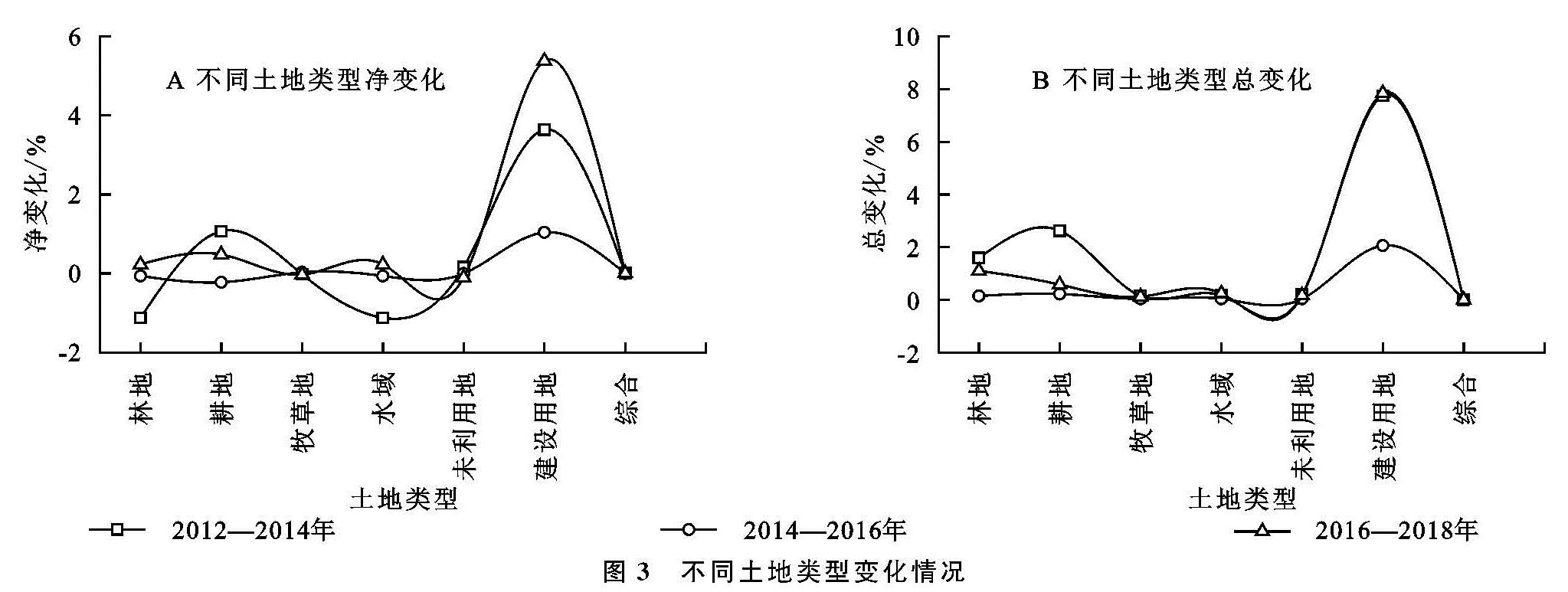
为了进一步分析各土地类型变化特性,通过式(1)—(4)中的单一土地类型净变化、总变化以及综合土地类型净变化以及总变化进行后续分析。从综合土地类型净变化与总变化程度来看(图3),2012—2014年这一时间段的变化程度最为剧烈,净变化率和总变化率分别为0.98%和0.59%; 变化程度最小的是2014—2016年,二者分别为0.15%和0.06%。从单一土地类型净变化与总变化程度来看,2016—2018年建设用地增长速度最快,净变化与总变化分别为5.38%与7.84%。除建设用地外,林地在2012—2014年的净变化最快,为-1.12%,耕地2012—2014年总变化最快,为2.62%。
3.2 土地利用类型空间变化分析
土地利用类型转移矩阵可以反映不同土地利用类型间的相互转移情况,便于分析土地利用类型的变化过程。基于式5,得到了表3的党河流域2012—2018年期间土地利用类型转移矩阵,具体各类土地转入、转出以及增加情况见图4。
从不同土地类型面积变化量来看,林地6 a间面积减少量最大,为82.13 km2。建设用地转入面积始终大于转出面积,其土地面积持续增加。从转入转出角度来看,未利用土地6 a间的转入量最大,为107.76 km2,转入面积中林地为主要贡献源,转入总面积88.72 km2,林地砍伐后成为了未利用土地。其中,林地转出量最大的时间段为2012—2014年的72.68 km2,后续2016—2018年未利用土地转出为林地50.45 km2。转入为建设用地最多的土地类型为未利用土地,6 a间总转入面积13.15 km2,在一定程度上说明加快了未利用土地向建设用地的开发利用转变以及开始重视林地保护。
从总体上来看,2012—2018年土地利用类型呈现林地退化转变为未利用土地,生态建设加强后未利用土地回转为林地和向建设用地转变的大趋势。这在一定程度反映了研究区在沙漠治理、天然林保护、国家公益林保护建设等林业生态工程建设上的效果良好。
3.3 景观格局动态变化分析
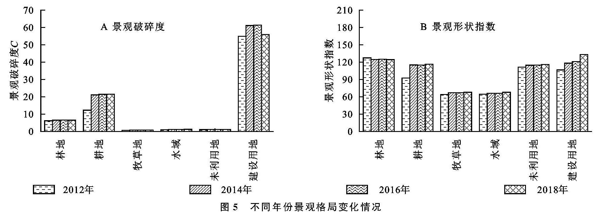
为了分析在上述土地类型变化过程中对应的景观动态变化趋势,从景观破碎度Ci、景观形状指数LSI等角度研究了党河流域6 a内变化情况并分析变化原因。从景观破碎度来看(图5),建设用地破碎程度高,景观连续性差,人为干扰程度大。6 a间的平均景观破碎度从大到小分别为建设用地(58.33)、耕地(19.05)、林地(6.42)、水域(1.13)、未利用地(1.11)、牧草地(0.77)。2012—2016年各地类景观破碎度均呈增长趋势,2016—2018年林地和建设用地减少,其他地类继续增长。
从景观形状指数来看,景观形状指数表征景观形状的异质性,景观形状指数越大,斑块越离散。6 a间,未利用地与建设用地的景观形状指数均呈现上升趋势。各土地类型的平均景观形状指数由大到小分别为林地(125.31)、建设用地(119.69)、未利用地(114.17)、耕地(109.68)、牧草地(66.49)以及水域(66.03)。