2.1 1961-2017年百色地区极端降水时间变化
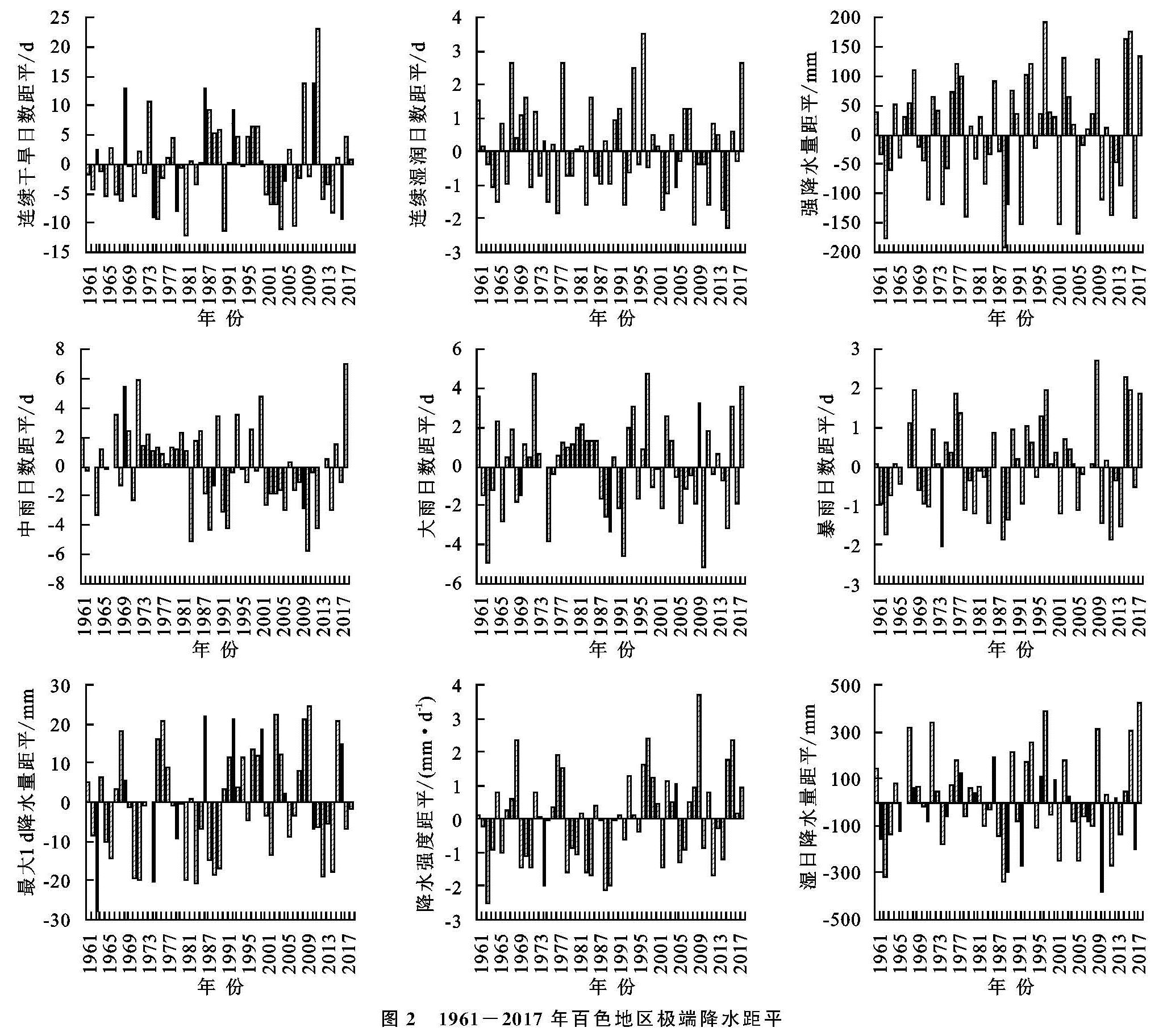
表2为1961—2017年百色地区各站点9个极端降水指标M-K统计量情况,图2为1961—2017年百色地区极端降水距平图。可以看出,对于相对干燥的降水变化而言,CDD指数能代表百色地区持续干旱的最大天数,从侧面上反映极端降水异常。CDD指数的距平值基本维持在±15 d之间,距平值的变化可分为4个阶段进行分析。在1961—1980年,CDD指数整体为负距平,在20世纪70年代中期由“波动下降”转为“波动上升”再转为“波动下降”,且下降趋势持续到1985年。对比相同阶段的CWD指数,该阶段整体为正距平,与CDD指数呈相反趋势。1980—2000年CDD指数整体为正距平,但数值偏小。2000年之后,正负距平集中年份更为明显,正距平集中分布在2010年,且达到最大值。对比CWD指数在该阶段的变化,整体以负距平为主,直至2017年左右才慢慢转变为上升趋势,说明在21世纪初期,干旱日数增大,百色地区整体偏干。据人民网报道,2009—2012年广西出现较为严重的干旱,以2010年最为严重。百色地区的干旱达到特大等级,旱情乃60 a一遇,造成209.76万人受旱,农业经济损失4.66亿元。由此可见,连续干旱日数的极端变化,使得原本湿润的桂西北地区面临干旱的挑战,可能原因在于百色地区位于云贵高原向华南沿海过渡的地带,多丘陵山地,灌溉水平普遍较低,且降水相对较少,蒸发量偏大,最易受干旱影响。另一方面,对于相对湿润的降水变化而言,CWD,R10,R20和湿日降水量指数能代表湿润期极端降水的变化。从整体上看,2000年之前,极端降水总体为正距平,且变化趋势由“波动上升”转为“波动下降”再转为“波动上升”。2000年之后,极端降水指数总体为负距平,直至2017年才转为正距平。
表2 1961-2017年百色地区极端降水指数M-K统计量
对于降水强度变化而言,R50,R95p,RX1 day和SDII指数能从降雨的强度上反映极端降水的变化。从整体上看,这4个指数的距平值波动范围更大,说明百色地区的降水趋于强烈。SDII的距平值波动范围最大,正距平最大值在1997年达到180 mm,负距平最大值在1988年达到190 mm。R50指数的正距平变化波动较为明显,负距平变化较为均匀。RX1 day和SDII指数距平变化趋势基本一致,以20世纪90年代为分界点,往前为负距平,往后为正距平。这3个指数的变化趋势对比CDD指数,发现上升和下降的趋势基本相同,如在1961—1985年,CDD指数呈现下降趋势,R50,RX1 day和SDII指数也显示出下降趋势; 在20世纪90年代,CDD指数与R50,RX1 day和SDII指数呈现较为一致的上升趋势,说明百色地区的降水在时间变化上更加集中,使得旱涝的发生更为连续且分明。
从极端降水指数M-K统计值Z来看,隆林县仅有R50指数通过90%的显著性检验,其他指数未通过,变化较为平稳。西林县有CDD,RX1 day和SDII通过90%的显著性检验,其他指数变化趋势不显著。乐业县有CDD和CWD指数通过90%的显著性检验,两指数上升趋势明显。凌云县R10指数的Z值达到-2.33,通过99%的显著性检验,说明该指数下降显著,其他站点未通过检验。田林县的R10指数统计值Z达到-3.24,通过99%的显著性检验,下降趋势明显。CWD指数通过90%的显著性,下降趋势同样显著。那坡县RX1 day指数通过90%的显著性上升检验,R10指数通过90%的显著性下降检验。百色市的RX1 day指数通过90%的显著性下降检验,其他指数变化不明显。田阳县有4个指数变化趋势显著,分别是R95p,SDII,R50和RX1 day,都通过90%的显著性上升检验。德保县的极端降水指数未通过检验,说明极端降水变化不显著。靖西的极端降水指数变化较为显著,R95p和RX1 day通过90%的显著性上升检验,SDII通过95%的显著性上升检验,R10指数通过90%的显著性下降检验。田东县有SDII,R50和RX1 day通过90%显著性上升检验,其他指数变化趋势不显著。平果县的SDII通过90%的显著性上升检验,R10通过90%显著性下降检验。综上所诉,1961—2017年百色地区12个气象站点中,仅有靖西的极端降水指数未通过90%的显著性检验,说明其变化平稳,其他11市县的极端降水指数均有显著性变化,说明上升或下降的趋势显著。
总的来说,1961—2017年,百色地区极端降水年尺度只有部分站点通过90%的显著性增加趋势,小部分站点通过95%显著性检验,整体上微弱增加。另外,R50,RX1 day,R95p,SDII和CDD共5个指数年尺度均表现出增加趋势,其他指数微弱下降。说明百色地区弱降水在减少,强降水在增加,干旱日数也在增加,使得降水趋于强烈和集中,降水趋于极端化。
2.2 1961-2017年百色地区极端降水空间分布
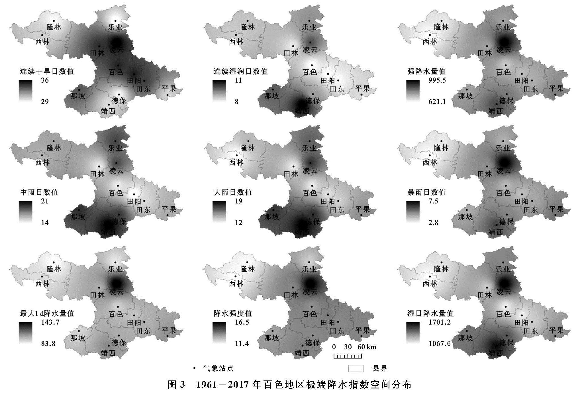
图3表示1961—2017年百色地区极端降水和M-K统计量Z值在空间上的分布。对相对干燥的降水变化而言,1961—2017年百色地区的CDD指数最大值位于中东部的右江河谷地区,以凌云、百色和田阳为主要站点,最高值达到36 d; 最小值分布在北部、西北和南部地区,以乐业、隆林和德保为主要站点。再从相对湿润的降水变化来看,CWD,R10,R20和湿日降水量在空间上的分布趋势基本一致。降水最高值位于凌云县和靖西县,最低值位于右江河谷地区和西北部的隆林和西林。CWD指数最高值位于靖西,达到11 d; R20和R10指数最高值都分布在最北部的乐业县和凌云县,以及南部的靖西、德保和那坡,最低值沿右江河谷分布,主要集中在百色和田阳等地; 湿日降水量在凌云和靖西达到最大值,为1 701.2 mm。将CWD,R10,R20和湿日降水量与CDD指数对比,发现它们空间分布呈相反趋势,说明57 a来百色地区右江河谷的CWD,R10,R20和湿日降水量等四个指数在减少,连续干旱日数增多。百色右江河谷较为干旱的原因,一方面可能由于地形的影响。右江河谷位于云贵高原边缘,形似一条狭长的走廊,不利于天气系统发育。而且多山间盆地,平均海拔50 m,周围山地平均海拔1 000 m,西北部最高点与东南角最低点海拔相差达2 000 m。在日降水量小于1 mm的持续日数中,盆地中的蒸发量明显大于周围山地。另一个方面可能是由于其特殊的地理位置,使得焚风效应显著且海上的湿润气流到达该地时已经缺少含水量,以及台风等降水系统的偏移,导致右江河谷干旱日数多,湿润日数较少,这与广西桂西北地区极端连续降水量减少的事实相符[33],也使得其成为全区降水量最少的地区[34]。
从极端降水指数M-K统计值Z在空间上的分布来看,见附图2,持续性指数中,CDD指数Z值高值区位于乐业县、西林县和靖西县,呈现出北部、西北部地区上升趋势显著,东南地区以下降趋势为主的分布格局。CWD指数则呈现出南部大部分地区、北部和西北地区以上升趋势为主,田林县周围地区以下降趋势为主的分布格局。绝对指数中,R10和R50指数的Z值在空间上的分布具有相似性,大体呈现出东南部和西北部上升趋势显著,而中西部以下降趋势为主的分布形式。R20指数则以中部地区,如田林和百色等站点以上升趋势为主,其他地区以下降趋势为主的分布格局。阈值指数与强度指数的Z值在空间上的分布更为相似,以东南部地区上升为主,以田阳、田东和靖西为主要高值区,西北部下降趋势明显。综上可知,几乎每个站点的极端降水均发生显著性变化,且具有较为相似的趋势,能够反映出各站点极端降水指数的变化规律以及区域极端降水指数的分布情况,在百色地区做到能准确分析降水时间、强度及其分布位置,以期降低极端降水带来的风险。
图3 1961-2017年百色地区极端降水指数空间分布
极端降水指数空间分布叠加上M-K统计值,可以指示百色地区各站点降水的极端变化情况。极端降水年尺度空间差异明显,而且所有指数空间分析结果均以凌云县为极大值中心,大体呈现出东南地区以上升趋势为主,西北地区以下降趋势为主的格局,可能与该地区特殊地形因素有关。降水高频区主要位于有地形抬升、大气辐合上升的山脉周围。
对于降水强度变化而言,R50指数最高值位于凌云县和靖西县,达到7.5 d,最低值位于西北部的西林县和隆林县,只有2.8 d; R95p指数高值中心位于凌云县和靖西县,降水量达到995.5 mm,低值中心位于右江河谷和西北部的隆林县和西林县; RX1 day和SDII的高值中心基本位于凌云县和靖西,降水量从东南向西北递减。总的来说,R50,R95p,RX1 day和SDII指数在空间上的分布都遵循着以凌云为高值中心,以隆林和西林为低值中心,数值从东南向西北递减的规律。但对比CDD指数来看,这4个指数与CDD指数的高值区都位于凌云,说明57 a来凌云不仅是百色地区的降水强度高值中心也是干旱少雨中心,这进一步揭示了凌云的降水更趋于集中和强烈,使得旱涝更明显,降水趋于极端。综上可知,极端降水出现频率高的站点主要位于有地形抬升、大气辐合上升的山脉周围,如凌云和靖西两个站点。因此,百色地区的地形因素是影响极端降水空间分布的主要原因。受到夏季风影响,南海水汽输送至广西境内,成为广西降水的主要条件,百色地区位于广西降水最尾端,降水量在空间上的分布也遵循着东南多西北少的规律。然而,凌云和靖西两县的西北部背靠山地,迎接来自东南部的水汽,形成迎风坡,水汽辐合上升降水量大,常年形成百色地区暴雨中心[35]。