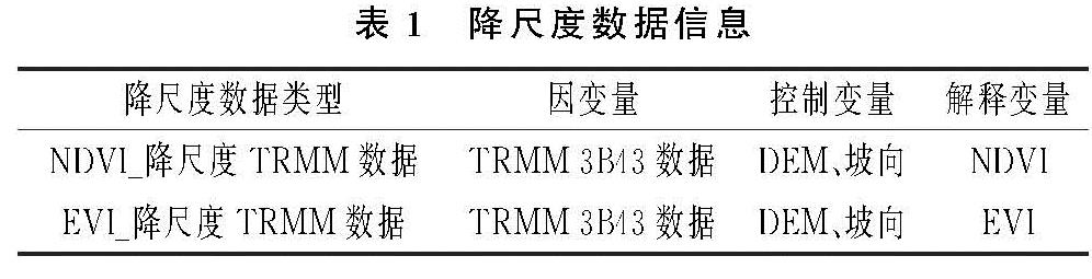
3.2 降尺度结果与验证
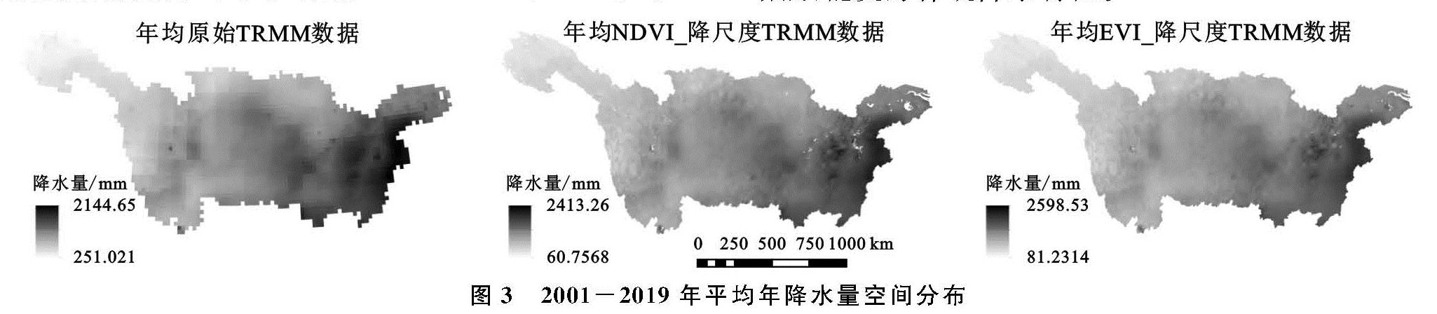
3.2.1 多年平均降水降尺度结果 对2001—2019年的TRMM 3B43年累计降水数据、年均NDVI数据、年均EVI数据分别求平均得到多年平均数据,通过GWR模型获得降尺度TRMM数据。由图3可知:TRMM原始数据年均降水范围为251~2 145 mm,NDVI_降尺度TRMM数据范围为60~2 415 mm,EVI_降尺度TRMM数据为81~2 599 mm; 洞庭湖支流区域降尺度前后细节表征更突出。整体空间分布特征上,TRMM数据在降尺度前后趋于一致,呈现由东向西递减的特点,其中东南地区年降水量一般大于1 600 mm,局部地区大于2 000 mm。原始TRMM数据空间分辨率相对较粗糙,局部特征不明显,经过GWR降尺度计算,空间分辨率从0.25°提升至1 km,其降水范围大于原始TRMM数据,细节性增强,能更好体现降水特征。
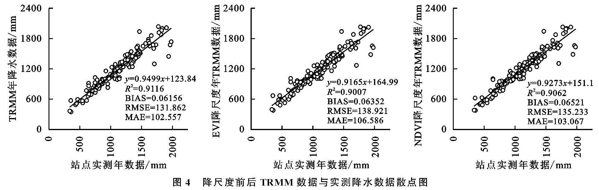
为进一步验证TRMM数据降尺度结果的准确度和精度,将研究区内147个气象站点多年平均观测数据分别与对应的降尺度前后TRMM数据进行一元线性回归分析(图4),以R2,BIAS,RMSE和MAE共4种统计指标对降尺度结果进行验证。验证结果表明:TRMM降水数据与气象站点观测数据之间的R2,BIAS,RMSE以及MAE分别为0.911 6,0.061 56,131.862,102.557,TRMM降水数据与气象站点观测数据之间具有明显的线性相关性,且原始TRMM数据的降水量整体比站点观测数据降水量偏大。
与TRMM原始数据的降水量相比,两种降尺度数据的R2,BIAS均有所下降,RMSE和MAE略微上升。NDVI_降尺度降水数据R2指标值为0.906 2,更接近于0.911 6; BIAS值增加了0.019 6,RMSE指标值提升了3.371 mm,MAE提升0.51 mm; EVI_降尺度降水数据R2指标值为0.900 7,减少了0.010 9,BIAS值增加0.036 5,RMSE指标值提升了7.059 mm,MAE提升4.029 mm。整体来看,NDVI_降尺度模型相比EVI_降尺度模型精度更高。
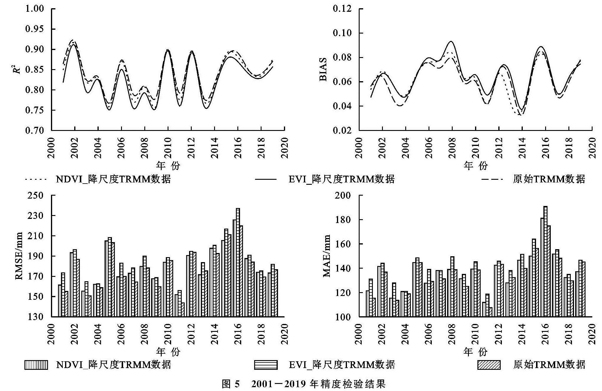
3.2.2 年尺度降水降尺度 把2001—2019年气象站点的实测降水数据和对应的原始TRMM 3B43降水数据、NDVI_降尺度TRMM数据、EVI_降尺度TRMM数据进行逐年检验和对比分析。图5为3种数据与气象站点实测降水数据精度检验得出的4种参数对比图。由图5A可知:2001—2019年3种降水数据各年R2曲线趋势表现为明显的一致性,19 a间原始TRMM数据与气象站实测降水量的R2普遍相对较好; NDVI_降尺度降水量与气象站实测降水量的R2与前者几乎接近,2010年、2019年比前者相关性更好; EVI_降尺度降水量与气象站实测降水量的R2相比前两种表现稍差。降尺度前后数据的R2有所下降,其原因是在尺度转换过程中会产生误差,导致降水量估计有偏差。图5B-5D为3种数据与站点实测数据的BIAS,RMSE及MAE值的对比,其中BIAS原始TRMM数据表现最好,NDVI_降尺度降水数据次之,EVI_降尺度降水数据相对较差; 2006年、2010年、2012年、2015年、2019年NDVI_降尺度降水数据与气象站点实测数据的RMSE和MAE最小,能更好反映真实降水,其余各年略微低于原始TRMM数据; 各年内EVI_降尺度前后TRMM降水数据与气象站实测数据间的RMSE和MAE都大于另两种数据,精度相对较差。整体而言,DVI_降尺度结果优于EVI_降尺度结果,在提高空间分辨率的同时较好地保持数据的精度,能更真实地反映研究区域内的降水特征。
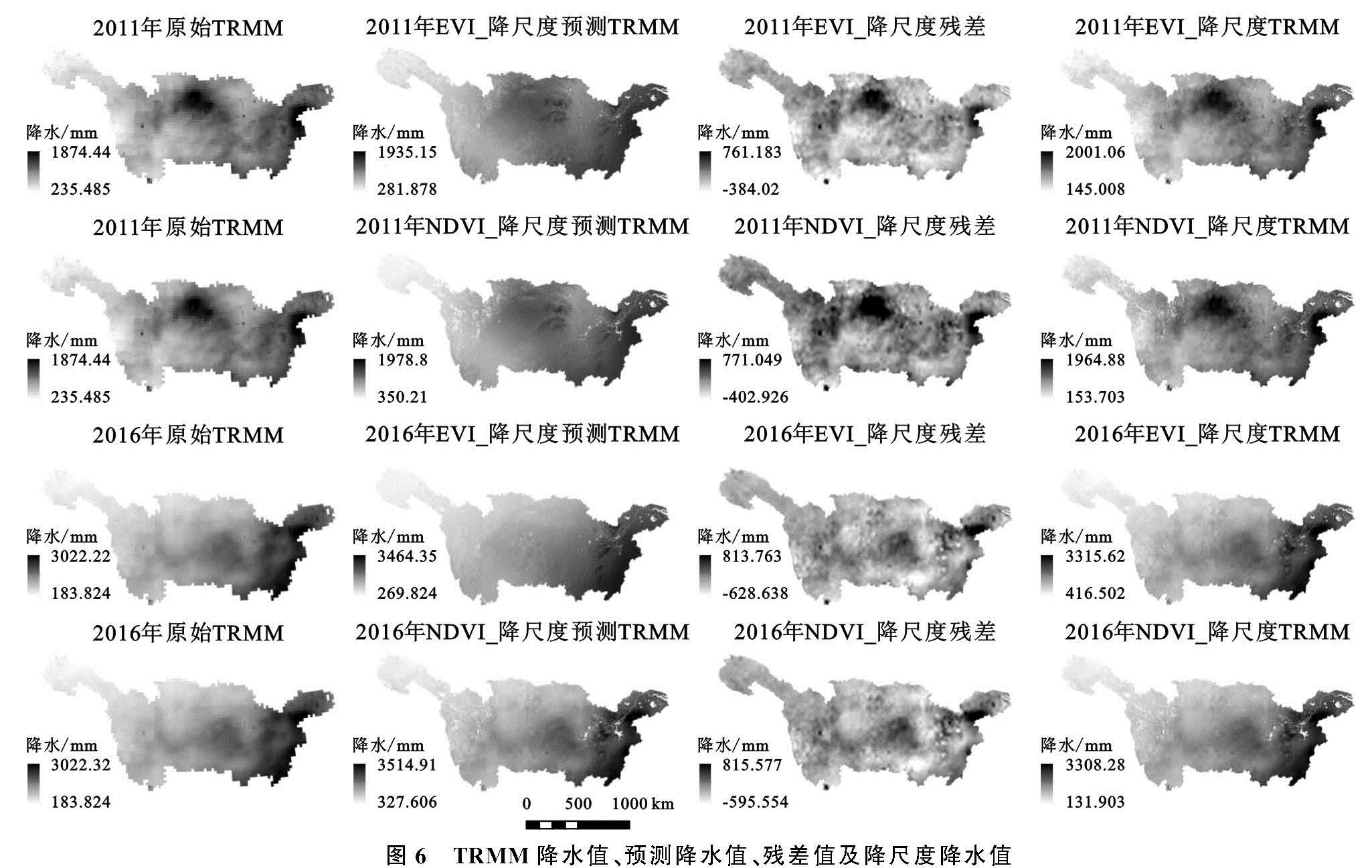
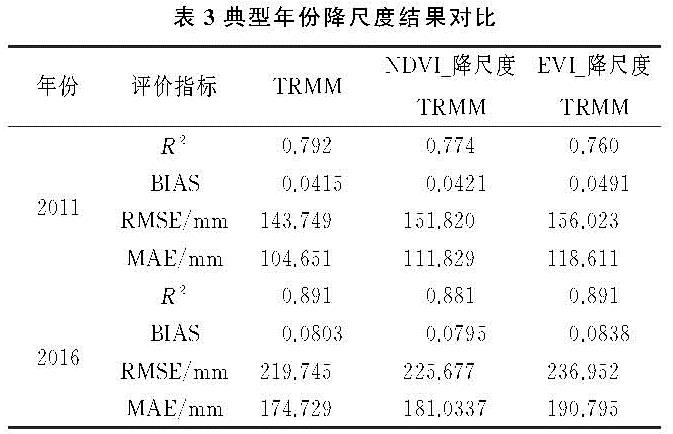
3.2.3 典型年降水降尺度结果与验证 2001—2019年年均降水量为1 109.31 mm,2011年降水量924.91 mm为近19 a最低,2016年降水1 287.25 mm为近19 a最高。以2011年作为干旱年、2016年作为湿润年,进行典型年份降水降尺度结果与分析。按上述降尺度步骤对2011年、2016年TRMM数据进行降尺度,得到相应年份的NDVI_降尺度预测TRMM和EVI_降尺度预测TRMM(图6B),并对残差插值得到(图6C)1 km残差值,最后得出相应年份的NDVI_降尺度TRMM数据和EVI_降尺度TRMM数据(图6D)。由图6可知,两种降尺度结果空间分辨率都有大幅度提升,细节性增强,能更好地体现降水特征。典型年份(2011年、2016年)的降水量空间分布趋势与多年年均降水相近,整体呈现从东向西逐渐减小的趋势,其中,干旱年份降水主要分布在长江流域中北部和东北部,湿润年份降水主要分布在长江流域东南部。2011年原始TRMM年均降水范围为235~1 874 mm,NDVI_降尺度结果降水范围为153~1 964 m,EVI_降尺度结果降水范围为145~2 001 mm; 2016年原始TRMM年均降水范围为183~3 022 mm,NDVI_降尺度结果降水范围为131~3 308 mm,EVI_降尺度结果降水范围为116~3 315 mm。两种降尺度结果都使降水区间范围扩大,NDVI_降尺度数据范围变化相对较小,更加符合实际降水特征。
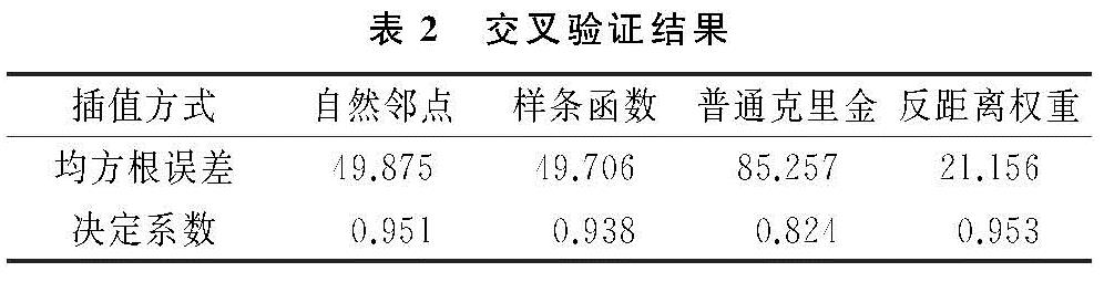
利用长江流域2011年、2016年147个气象站点实测数据对两种降尺度结果进行验证。从表3可以看出湿润年份R2整体优于干旱年份,且2个年份的NDVI_降尺度TRMM数据和EVI_降尺度TRMM数据与原始TRMM数据相比,R2均有所下降,但NDVI_降尺度数据R2更接近; BIAS,RMSE,MAE均有所上升,NDVI_降尺度TRMM数据精度要好于EVI_降尺度TRMM数据。
图6 TRMM降水值、预测降水值、残差值及降尺度降水值