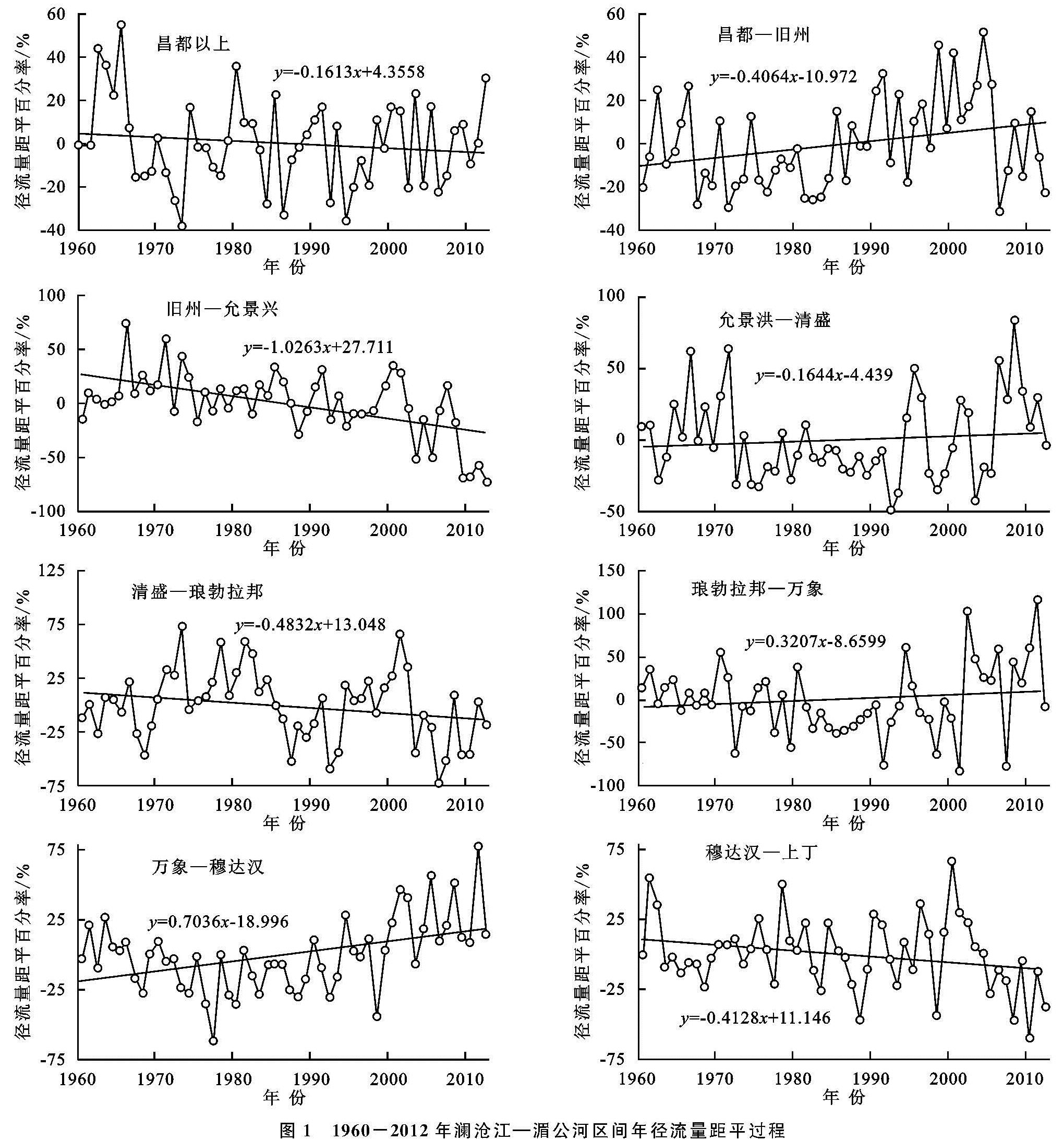
2.1 1960-2012年实测年径流量演变趋势
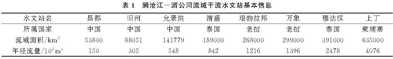
采用Mann-Kendall趋势检验法诊断了8个水文站及区间实测年径流量的演变趋势(表2),由于一区为源头区,区间径流量即为昌都站实测径流量,图1给出了8个区间1960—2012年径流量距平百分率过程。
表2 澜沧江-湄公河流域区间及站点1960-2012年实测年流量趋势诊断
由表2可以看出:(1)旧州站和穆达汉站实测径流量为非显著性增加趋势,平均线性倾向率分别为1.23,14.66 m3/(s·a); 其余6个水文站的实测年径流量均呈现减少趋势,其中,允景洪站减少趋势显著,平均线性递减率为-6.69 m3/(s·a);(2)在区间径流量的变化方面,一区、三区、五区和八区年径流量呈现减少趋势,其中,三区(旧州—允景洪)径流量减少趋势显著,平均线性递减率为-7.92 m3/(s·a); 其余4个区间径流量为增加趋势,二区和七区年径流量为显著性增加,线性增加率分别为2.00,24.13 m3/(s·a);(3)径流量的倾向率变化与站点或区间径流量的大小和径流变化趋势的显著性都有很大的关系; 一般来说,径流量较大的站点或区间,其线性倾向率一般也会较大; 譬如,尽管允景洪站实测径流量显著减小,琅勃拉邦和万象站为非显著性减小,但琅勃拉邦和万象站径流量的线性倾向率高于允景洪站。(4)区间径流量汇入下游站点,势必对下游站点径流量的变化有一定影响,有时会产生非常显著的影响。如昌都站径流量呈现减少趋势,由于二区径流量的显著增多,导致下游旧州站实测径流量呈现增加趋势。(5)相比而言,旧州、允景洪、穆达汉和上丁站径流量变化主要受该站的上游区间来水影响明显; 而清盛、万象站径流量的变化受上游区间的入流站点的影响明显。
由图1可以看出:(1)一区(昌都站以上)最大和最小径流量均发生在1980年之前,在20世纪60年代水量相对偏丰,70年代相对偏枯; 实测径流量以自然波动为主,变化幅度有减小趋势; 六区(琅勃拉邦—万象)径流量变化特征与一区相反,极值流量出现在2000年之后,变化幅度具有增大趋势。(2)四区(允景洪—清盛)和七区(万象—穆达汉)径流量演变态势类似,均为先减小后增加的趋势,这两个区间在20世纪70,80年代为一个近20 a的相对枯水期。(3)三区(旧州—允景洪)和八区(穆达汉—上丁)径流量在2000年之前均为自然波动,21世纪以来出现明显的减少态势。(4)二区(昌都—旧州)径流量变化兼并具有二区和四区径流的演变特征,区间径流量在20世纪80年代中期之前具有减少趋势,随后上升趋势明显,在2000年前后达到峰值然后下降。而五区(清盛—琅勃拉邦)径流量以自然波动为主,最初和最后的两个十年径流量均相对偏低。
图1 1960-2012年澜沧江—湄公河区间年径流量距平过程
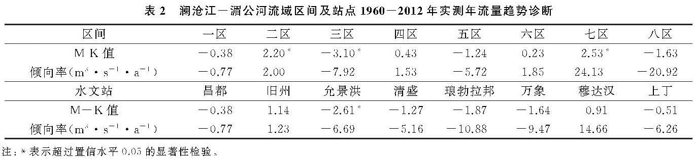
图2统计给出了湄公河8个区间在1960—2012年期间各个年代的年径流距平百分率及其多元趋势过程。可以看出:(1)有4个区间径流量年代际变化趋势总体一致,分别为昌都以上、允景洪—清盛、琅勃拉邦—万象和万象—穆达汉区间,均表现为先减少后增加的趋势。(2)昌都—旧州和清盛—琅勃拉邦区间径流量年代际变化趋势总体相反,昌都—旧州在1990s和2000—2012年径流量较多年均值分别增加13.2%和8.7%,而清盛—琅勃拉邦区间径流量在这两个时期较多年均值分别减少4.9%和12.2%。(3)穆达汉—上丁区间径流量年代际变化具有明显的丰枯交替特征,而旧州—允景洪区间径流量则出现较为明显的减少趋势,该区间2000—2012年径流量较多年均值偏少25.2%。
图2 澜沧江-湄公河流域8个区间年代径流量距平过程
2.2 干流水文站及区间径流量的变异特征
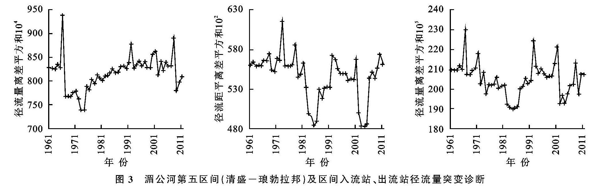
当流域受到气候要素的剧烈变化或者高强度人类活动的影响,水文过程会相应地发生突然增加或减少的变化。采用有序聚类方法诊断了站点及区间径流量系列的突变点(表3),图3给出了清盛、琅勃拉邦及清盛—琅勃拉邦区间径流量离差平方和序列过程。
区间下游站流量不同程度上受区间径流量和区间上游站流量的影响,清盛站径流量在1973年发生突变,琅勃拉邦站及清盛—琅勃拉邦区间径流量均在1985年和2003年发生突变。琅勃拉邦径流量突变特征与其上游区间径流量突变特征完全一致,与区间上游站清盛站突变特征不同,说明琅勃拉邦站径流量变化主要受区间来水影响,相对来说,受区间上游入流影响相对较小(图3)。
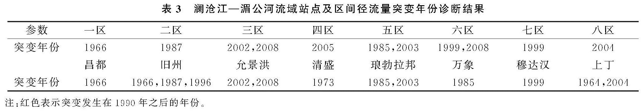
表3 澜沧江—湄公河流域站点及区间径流量突变年份诊断结果
图3 湄公河第五区间(清盛-琅勃拉邦)及区间入流站、出流站径流量突变诊断
由表3可以看出:(1)7个区间实测径流量突变年份存在差异; 三区、五区和六区实测径流量序列存在两个突变年份,另外4个区域径流量只存在一个突变年份; 最早的突变点发生在1985年(五区径流量),最晚的突变点发生在2008年(三区和六区径流量)。(2)8个水文站中有4个水文站(昌都、清盛、万象和穆达汉)的径流量只存在一个突变年份,另外4个水文站实测径流量存在2个或3个突变点,最早的突变点发生在上丁站径流量系列的1964年,最晚的突变年份发生在2008年(允景洪站)。(3)区间径流量突变年份多集中在1999年及其以后的时期,只有二区和五区径流量的两个突变年份发生在20世纪80年代; 与区间径流量不同,站点径流量的突变年份多发生在20世纪,其中,超过一半的突变年份(7个)发生在20世纪90年代之前。(4)区间径流量变异点之间的关联性不大; 相比而言,一些站点径流量变异点与其上游区间径流量的变异性密切相关,譬如,三区(旧州—允景洪区间)径流量在2002年、2008年发生突变,与区间下游允景洪站径流量序列突变特征完全一致。
2.3 变化环境下澜沧江-湄公河径流量的年内分配特征
水电能源开发是澜湄流域重要的人类活动之一。统计结果表明,截至2016年,在澜沧江—湄公河干支流上修建了259座水库,其中,泰国修建水库数量最多,超过150座,其次为越南,为51座,老挝和中国修建的水库数量分别为29,30座。已有研究表明,水库等水利工程的修建在运行初期,由于水库蓄水会对年径流量产生一定影响,水库蓄水完成后的运行调度期间,其对年径流量的影响相对较小,但对径流年内分配的影响相对明显[22]。
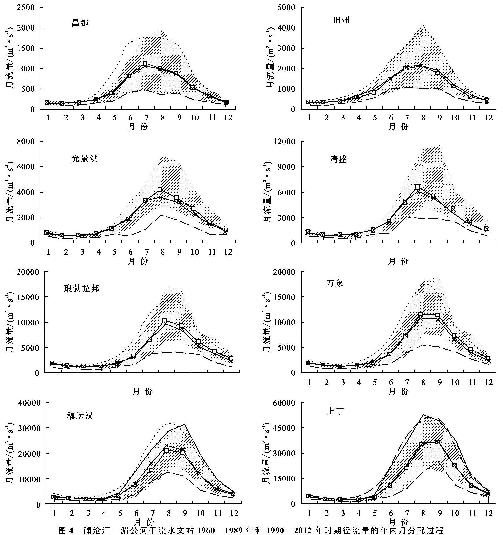
以干流水文站实测月径流量资料为基础,图4统计给出了8个水文站前期(1960—1989年)和后期(1990—2012年)两个时期径流量年内分配的变化过程,图4中灰色区域上下边界分别为1969—1989年期间各月径流量变化的范围,黑色圆点线为该时期多年平均月径流量; 上下灰色虚线和星号灰色虚线分别代表1990—2012年时期各月最大值、最小值和多年均值。
由图4可以看出:(1)澜沧江—湄公河从上游到下游所有8个水文站径流量年内分配模式一致,7—9月份是流量较大的主汛期,12月份到次年的4月份流量偏低,是湄公河的枯水季节。(2)1990—2012年时期3个峰值月份的最大流量和最小流量大多小于1960—1989年,特别是允景洪到万象之间的站点,峰值月份径流量变化区间普遍下移,下游穆达汉站和上丁站峰值月份流量变化区间在两个时段基本相当; 说明由于环境变化的影响,允景洪至万象站主汛期流量变小,湄公河该河段的防洪压力会有所减轻。(3)1990—2012年时期枯水季节各月的最大流量大多高于前期(1960—1989年)相应各月的最大流量; 同时发现,后期枯水季节各月的最小流量也大多小于前期相应月份的最小流量; 说明1990—2012年期间枯水季节月径流量变化幅度大于前期。枯水季节各月最大流量变大有利于湄公河枯季航运和沿河工农业发展用水,而各月最小流量的减小会对沿河两岸用水需求满足带来一定挑战。(4)从多年平均来看,旧州、穆达汉和上丁站在1990—2012年的各月多年流量大多高于前期(1960—1989年)多年平均流量,尽管对枯期水资源利用有利,但同时增大了汛期的防洪压力; 昌都源头区后期平均各月流量多低于前期,虽然利于防洪,但不利于水资源利用; 允景洪至万象之间的4个水文站后期(1990—2012年)多年平均8月、9月份流量低于前期均值,可以有效减轻沿岸的防洪压力。
图4 澜沧江-湄公河干流水文站1960-1989年和1990-2012年时期径流量的年内月分配过程
2.4 讨 论
目前已有研究多集中在澜沧江—湄公河干流水文站实测径流量的演变分析[18-21],由于干流水文站实测径流量的变化反映了该站以上整个区域的水文情势,并不能较好的体现区域径流量的变化态势。本文在计算区间径流量的基础上,分析了不同区域径流量及其演变情势,可以更好地支撑区域水资源利用与管理。
气温升高、降水变化通过改变水文循环进而对区域径流量产生影响,而水库建设、水电开发和工农业发展引起的用水量增加均对河川径流量产生直接的影响[4,22-24]。尽管不同区域径流量呈现丰枯交替的演变特征,但一些区域的最近十年径流量明显偏低(旧州—允景洪区间)或偏高(万象—穆达汉区间),同时,一些站点径流量年内分配也发生了一定的变化。这些区域径流量及其年内分配变化是由气候因素造成的自然变化还是人类活动影响造成的趋势性变化,是需要值得进一步研究的科学问题。