3.1 土地利用变化与情景设定
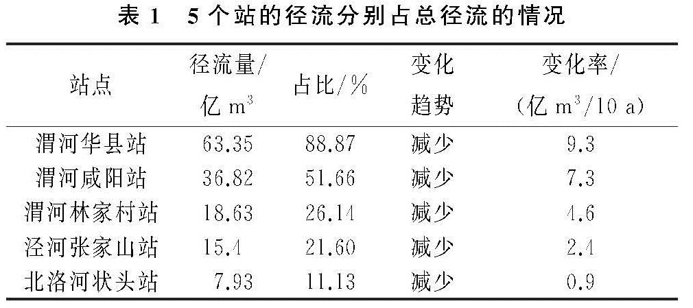
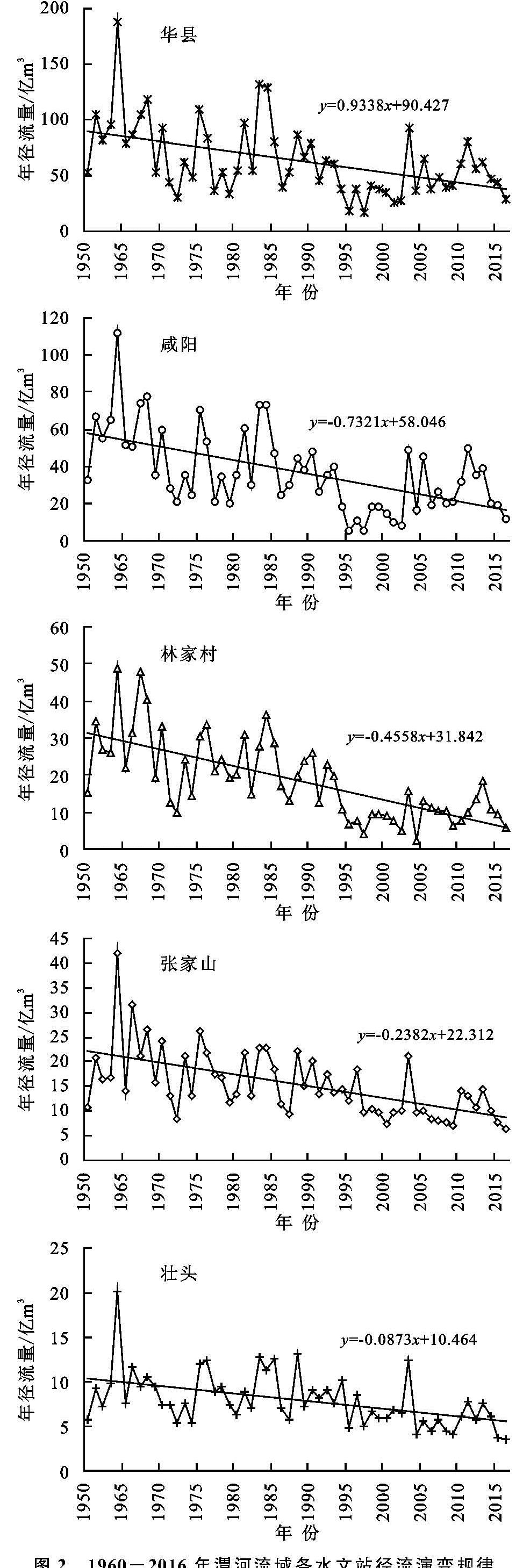
3.1.1 土地利用变化 根据渭河流域1980年、2000年、2015年三期土地利用空间分布,流域内土地利用类型以耕地、草地和林地为主,三者之和占总面积的95%以上,其中耕地面积占总面积的40%以上,草地占35%以上,林地占15%以上。对比1980年、2000年、2015年三期土地利用变化(表3); 耕地呈现出先增加后减少的趋势,2015年耕地面积较1980年减少约1961 km2; 草地和林地呈现出先减少后增加的趋势,增加出现在2000—2015年,林地增加量远大于前20 a减少量。居民地和工业用地面积呈现增加趋势且随着年代推移增加的面积越大,2015年比1980年居民地增加1139 km2,工业用地增加了206 km2。土地利用变化的形态直观的反映了区域城镇化、工业化的发展和我国实施退耕还林还草措施和90年代以来生态环境恢复与保护的国家策略。
表3 1980年以来渭河流域土地利用变化特征km2
在空间上,为了凸显土地利用变化区域,将三期土地利用变化图在GIS中进行叠加,可以直观的显示出土地利用在空间上的变化(图4)。根据GIS叠加计算结果显示,1980—2000年变化区域面积占流域总面积的1.47%,2000—2015年变化区域面积占2.42%,1980—2015年变化区域面积占3.56%。
3.1.2 情景设定 本文以1980年、2000年和2015年为代表,分析近35 a土地利用变化对径流及各区域水文过程的影响的差异性。然而近35 a土地利用变化是各土地类型互相转化的综合反映,以SWAT模型生成的子流域为基本单元较难分离出某一土地利用类型转化对径流及其他水文分量的影响。由此设立3种单一的土地利用情景(表4),分析土地利用类型互相转化对不同区域水文分量变化差异性的影响。为未来土地利用规划及流域水土资源配置提供一定的借鉴。
3.2 近35 a土地利用变化对径流的影响情况
流域出口断面径流发生变化同时流域水文过程也发生着变化,本文以土地利用变化为研究变量,分析土地利用变化对水文过程影响的空间差异性。着重分析蒸散发(ET)、地下水补给量(PREC)和地表产流量(SURQ); 蒸散发是流域水资源消耗的主要因素之一; 由于土地利用变化对地表的产流机制具有一定的影响,SURQ地表产流量是由降水引起的地表产生径流并汇入河道的水量。土地利用、植被类型的变化对产汇流过程中的植被的截留、地表产水系数等具有一定的影响,地表水流停留时间和降水入渗发生变化,进而对水分穿过根区底部到达浅水面有一定的影响,PREC地下水补给量是指根区底部的渗透水量,即水分离开根区底部到达浅层含水层的水量。
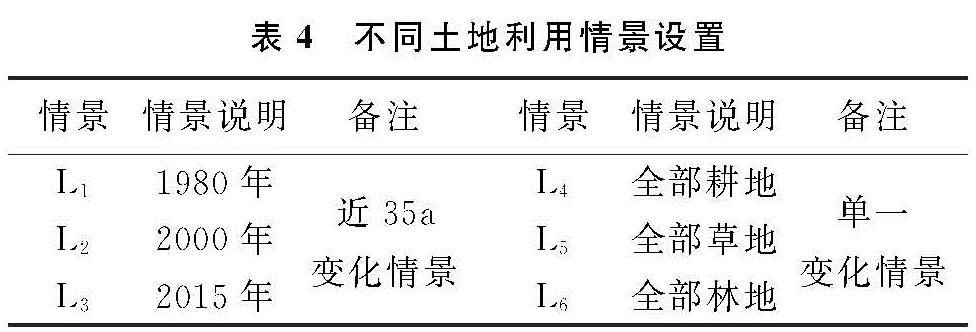
3.2.1 近35 a土地利用变化对水文分量及入黄径流量影响 在1980年、2000年和2015年土地利用情境下的各水文分量见图5,相对于L2和L1情景,在L3情境下全流域蒸散发分别增加0.39 mm和0.57 mm; 地表产流量减少了0.2 mm和0.66 mm; 地下水补给量分别增加了0.01 mm和0.03 mm。同时,比较2000年和1980年下垫面的变化也呈现出相似的特征。近35 a流域蒸散发和地下水补给的增加,地表产流量的减少,这与近些年城镇化和工业化发展水平的推进、退耕还林还草、植树造林和一些水土保持措施息息相关。
结合土地利用变化和水文分量变化分析,由于土地利用的变化量较小,水文分量变化并不明显。在水文分量发生变化背景下,分析可以综合体现水文分量发生变化的渭河流域径流量(入黄流量)。结果见图5,2015年土地利用情景相比于2000年、1980年情景,径流分别减少了0.51亿m3,0.76亿m3。
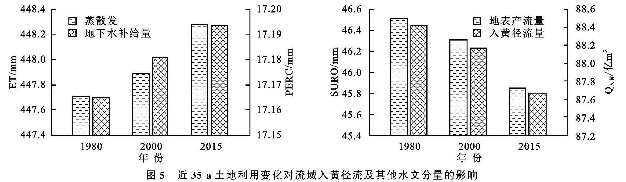
3.2.2 近35 a土地利用变化对水文分量空间差异性的影响 以SWAT模型划分的121个子流域和流域水资源的5个分区(北洛河流域、泾河流域、渭河上游、渭河中游和渭河下游)为基本单元,分析近35 a由土地利用变化引起流域水文分量的空间变化(图6)。(1)蒸散发空间变化2015年土地利用与1980年相比蒸散发空间变化集中表现为渭河中游和下游区域蒸散发变化相对较大,分别增长2.295 mm和1.719 mm; 而北洛河流域却呈现出蒸散发减少的态势,较1980年蒸散发减少了0.063 mm。(2)地下水补给量空间变化在土地利用变化过程中,渭河流域北部和西部(即北洛河流域、泾河流域和渭河上游)地下水补给量呈现出减少的趋势,而流域中游和下游呈现出增加趋势。2015年土地利用相比于1980年,渭河中游和下游地下水补给量分别增加了0.466 mm和0.213 mm,北洛河流域、泾河流域和渭河上游分别减少了0.076 mm,0.044 mm和0.0126 mm。(3)地表产流量空间变化2015年土地利用情境下相对于1980年全流域地表产流量均呈减少趋势,渭河中游和下游地表产流减少量较大,渭河中游地表产流量减少最大,减少了2.867 mm; 渭河下游地表产流减少量次之,减少量为1.959 mm,北洛河流域、泾河流域和渭河上游地表产流量变化较小,其变化量小于0.01 mm。
图5 近35 a土地利用变化对流域入黄径流及其他水文分量的影响
3.3 单一土地利用下的径流响应
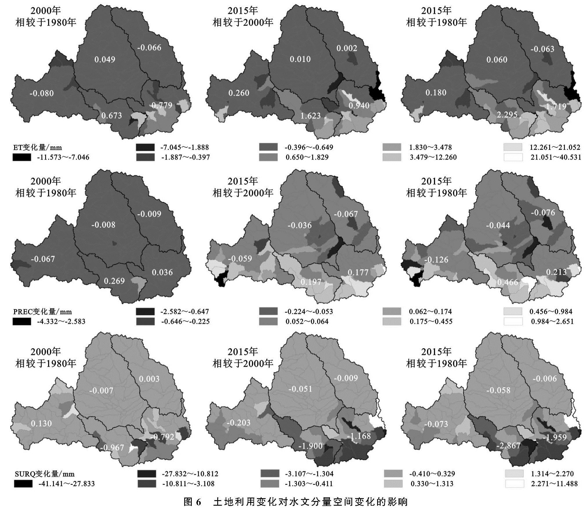
3.3.1 单一土地利用转化对渭河流域径流量影响 单一土地利用变化情境下的水文分量(蒸散发、地下水补给量和地表产流量)。比较L6情景与L4,L5可见,对整个流域平均水平而言,流域耕地转化为草地和林地,蒸散发增加了20.17 mm和45.83 mm,地下水补给量增加了4.14 mm和4.97 mm,地表产流量减少了24.59 mm和49.81 mm; 林草地具有较好水源涵养能力,可以增加地下水补给量,但减少地表产流量,对地表产流有较强的调蓄作用。
结合在单一土地利用变化条件下整体的流域水文分量情况,模拟入黄径流量的变化(图7),以分析单一的土地利用变化对流域河道径流的影响。由全部耕地(L1)情景转化为全部草地(L2)情景和全部林地(L3)情景入黄流量分别减少了27.31,60.95亿m3,由全部草地(L2)情景转化为全部林地(L3)情景入黄流量减少33.64亿m3。
通过以上对流域水文分量及入黄径流量的分析,各水文分量在土地利用转化过程中,具有一定的关联性,对于流域的土地利用规划不应该单一的强调某一分量的最大极值化,而应对流域土地利用进行综合规划以实现蒸散发、地下水补给量、地表产流量和径流量等分量最优化情景。
3.3.2 在空间变化差异性上土地利用转化对水文分量的影响 渭河流域地处大陆性季风气候区、干旱地区和湿润地区的过渡地带,西高东低,土壤、地貌类型复杂多变,由南向北为秦岭北坡、关中盆地以及黄土高原,相应的气候条件(流域降水分布由东南向西北递减)、土壤、地貌类型南北差异性较大[20-21],引起的南北产汇流类型具有一定的差异[20,22]; 即使相同的土地利用类型转化也会造成水文分量在空间上变化的不同。由此,对单一土地利用变化情景下水文分量的空间变化进行分析(图8),旨在分析水文分量对土地利用类型转化的空间响应关系。
进一步比较蒸发和地下水补给量可更加明晰的剖析由土地利用变化导致流域径流量变化的原因。由耕地转化为林地或草地,蒸散发(流域水平衡分项中的消耗量)呈现林地>草地>耕地。然而在区域降水量东南多西部少的背景下,对于北部降水量较小、土壤含水量较低的黄土区域,随着植被类型的变化,降水一方面被林草地植被截留消耗,另一方面蓄存于土壤非饱和带被蒸发和植物消耗,而导致地表径流量下降。对于中南部,降水量较为丰富,土壤含水量相对较高,在林草地对降水产流的滞留作用下,降水在地表滞留时间较长,地下水补给量较多; 同时林草地植被盖度远大于耕地,随着植被盖度的增加蒸发量也呈现增加; 在二者的共同作用下,区域的径流量必然减少。总体上,流域北部(降水较少区域)由土地利用变化引起径流减少的原因主要为蒸发与植物消耗,而中南部为降水滞留时间延长地下水补给量增加。
就地下水补给量(PREC)的空间变化而言,其空间变化特征为北部为减少态势,而中南部(关中平原与秦岭北坡)为增加态势。其原因在于地表产流量林地<草地<耕地,在流域北部地区降水量较少,虽然降水产流会被林草地滞留,但林地草地对水资源的消耗本身较大,降水多用于植物自身生长而吸收,进而较少水量可以穿过根区,因此北部地下水补给量(PREC)变少。
在渭河流域降水东南多西北少的空间分布背景下,当耕地转化为草地、林地或草地转化为林地时,流域蒸散发、地下水补给量和地表产流量的变化幅度均呈现出:干流区域大于支流区域、中下游区域大于上游区域的变化特点; 虽然南北相同土地利用变化,但是水文分量对土地利用变化呈现出来响应的敏感程度不同,中下游水文分量变化对土地利用变化更为敏感。