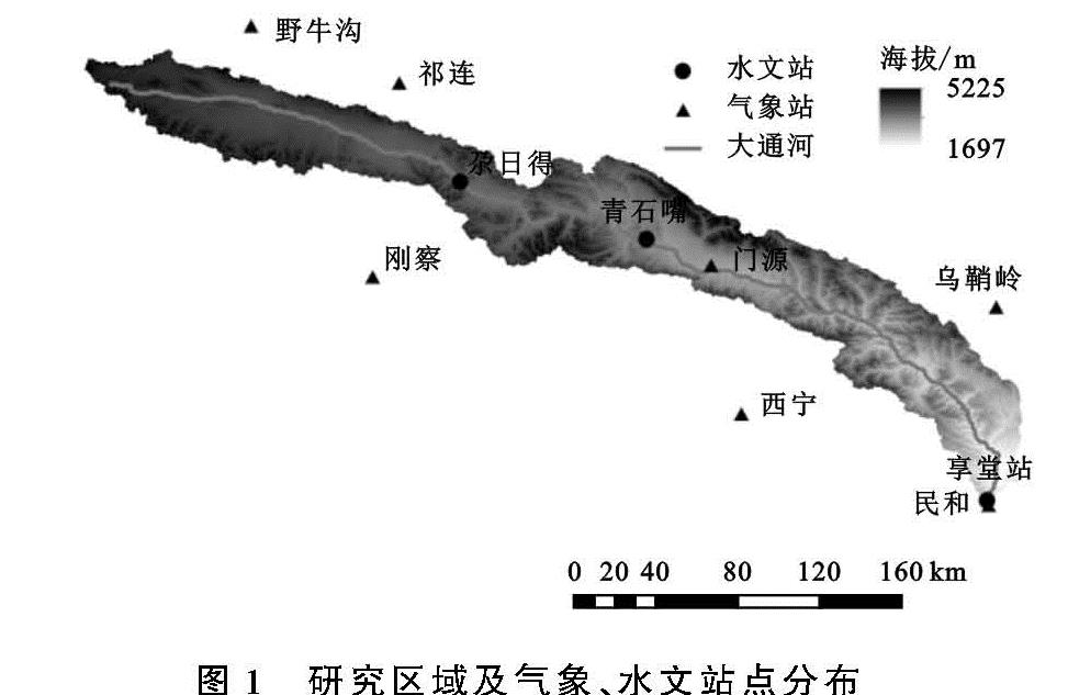
2.2.2 年际变化特征
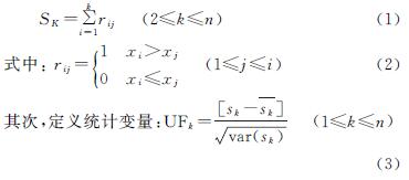
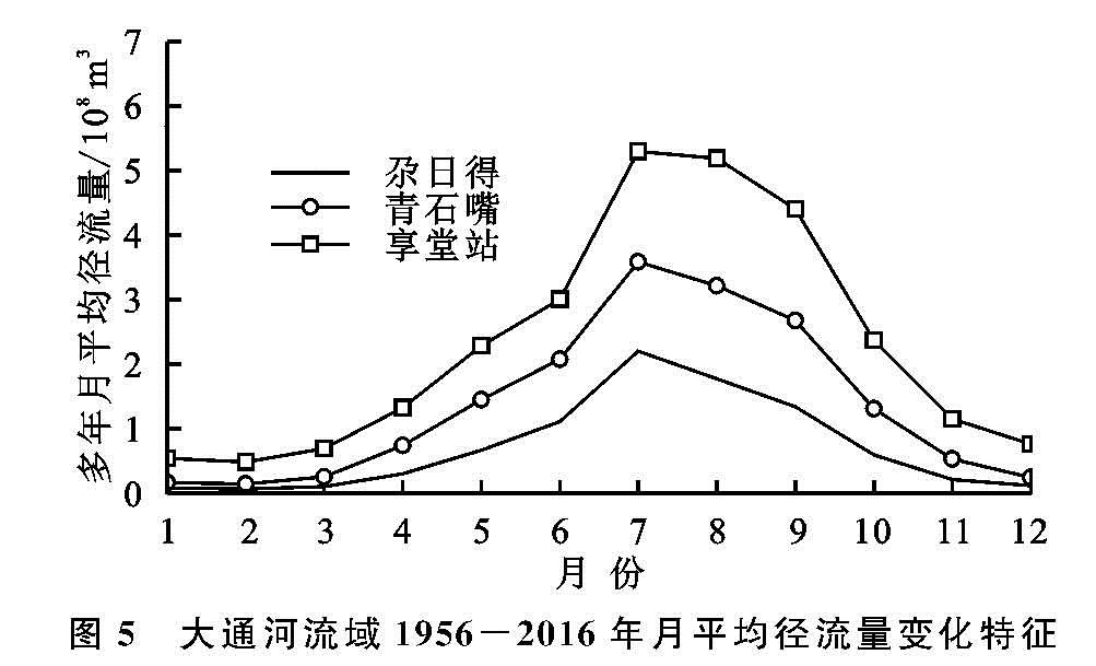
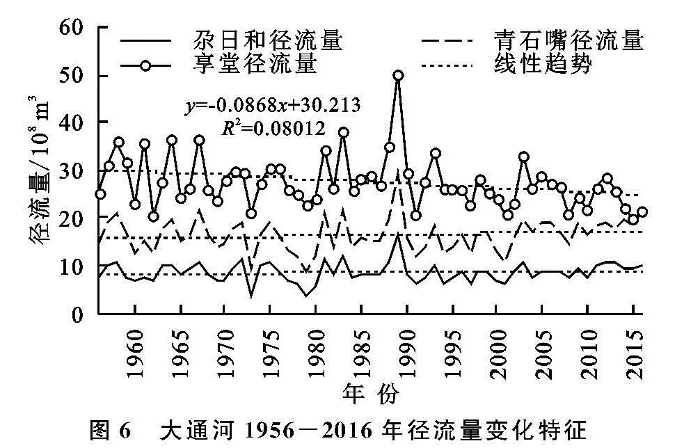
(1)径流变化趋势特征。1956—2016年大通河尕日得、青石嘴和享堂3个水文站多年平均径流量分别为8.53亿m3,16.39亿m3,27.52亿m3。其中,尕日得站年均径流量最大值出现在1989年的16.28亿m3,最小值出现在1973年的3.87亿m3,极差为12.41亿m3; 青石嘴站年均径流量最大值出现在1989年的29.3亿m3,最小值出现在1979年的8.64亿m3,极差为20.66亿m3; 享堂站年均径流量最大值出现在1989年的50.19亿m3,最小值出现在2015年的19.95亿m3,极差为30.24亿m3。由图6可知,除享堂站径流量呈现出下降趋势外(倾向率为-0.87亿m3/10 a(p<0.05)),尕日得和青石嘴站均呈现出一定的上升趋势,其上升速率分别为0.1亿m3/10 a,0.3亿m3/10 a。分析得到大通河上游、中游的尕日得和青石嘴站径流量呈增加趋势,这得益于近年来降水的增加及温度升高引起的冰雪融水消融,下游的享堂站受人类活动的影响(跨流域调水及下垫面的改变)径流量呈现下降趋势,这与董军等[9]关于大通河的研究结论基本一致,但其变化速率与之不同,主要是本文所选用的站点及研究时段不同导致的。气候因素一直影响大通河径流变化,但在一定的条件下,人类活动因素反而占据主导地位,人类活动与气候变化对大通河径流影响的具体细节仍需进一步工作。
(2)突变分析。运用M-K检验法对大通河1956—2016年径流量进行突变分析(图7),可以看出:尕日得站的UF与UB曲线在置信区间内存在多个交点,通过对累积距平和变化趋势进行分析后发现,尕日得径流量在2010年前后发生突变,突变前平均径流量为8.37亿m3,突变后平均径流量为9.98亿m3,突变后较突变前增加了1.61亿m3。通过分析其UF变化曲线可知,尕日得站在1956—1977年UF曲线波动剧烈,在1978—1987年和1994—2011年UF<0,径流量下降; 在2012—2016年UF>0,年径流量上升。根据青石嘴站M-K检验曲线、累积距平曲线及趋势特征综合分析判定其突变发生于2001年,突变前平均径流量为15.83亿m3,突变后平均径流量为18.13亿m3,突变后较突变前增加了2.3亿m3。通过分析其UF变化曲线可知,青石嘴站在1956—1959年、1964—1969年和2007—2016年UF>0,年径流量上升,但未超过信度曲线,增加趋势不显著; 1960—1963年、1977年、2006年UF<0,年径流量下降; 1970—1976年波动起伏剧烈。享堂站UF,UB曲线在置信区间内相交于2000年,结合累积距平曲线及其径流变化趋势特征认定2000年为享堂站的突变点,突变前平均径流量为28.59亿m3,突变后平均径流量为24.75亿m3,突变后较突变前减少了3.84亿m3。通过分析其UF变化曲线可知,享堂站UF曲线在1956—1976年波动起伏剧烈,1988—1995年UF>0,年径流量上升,1977—1987年和1996—2016年UF<0,径流量呈现出明显的下降趋势,其中2014—2016年超过信度曲线,下降趋势显著。
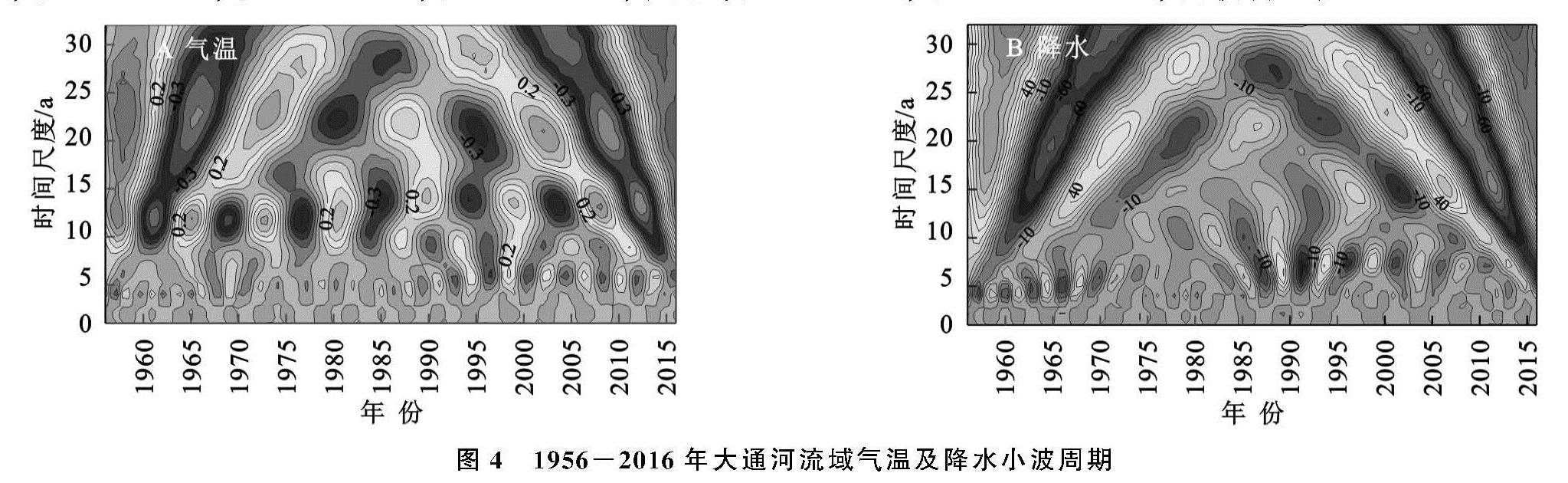
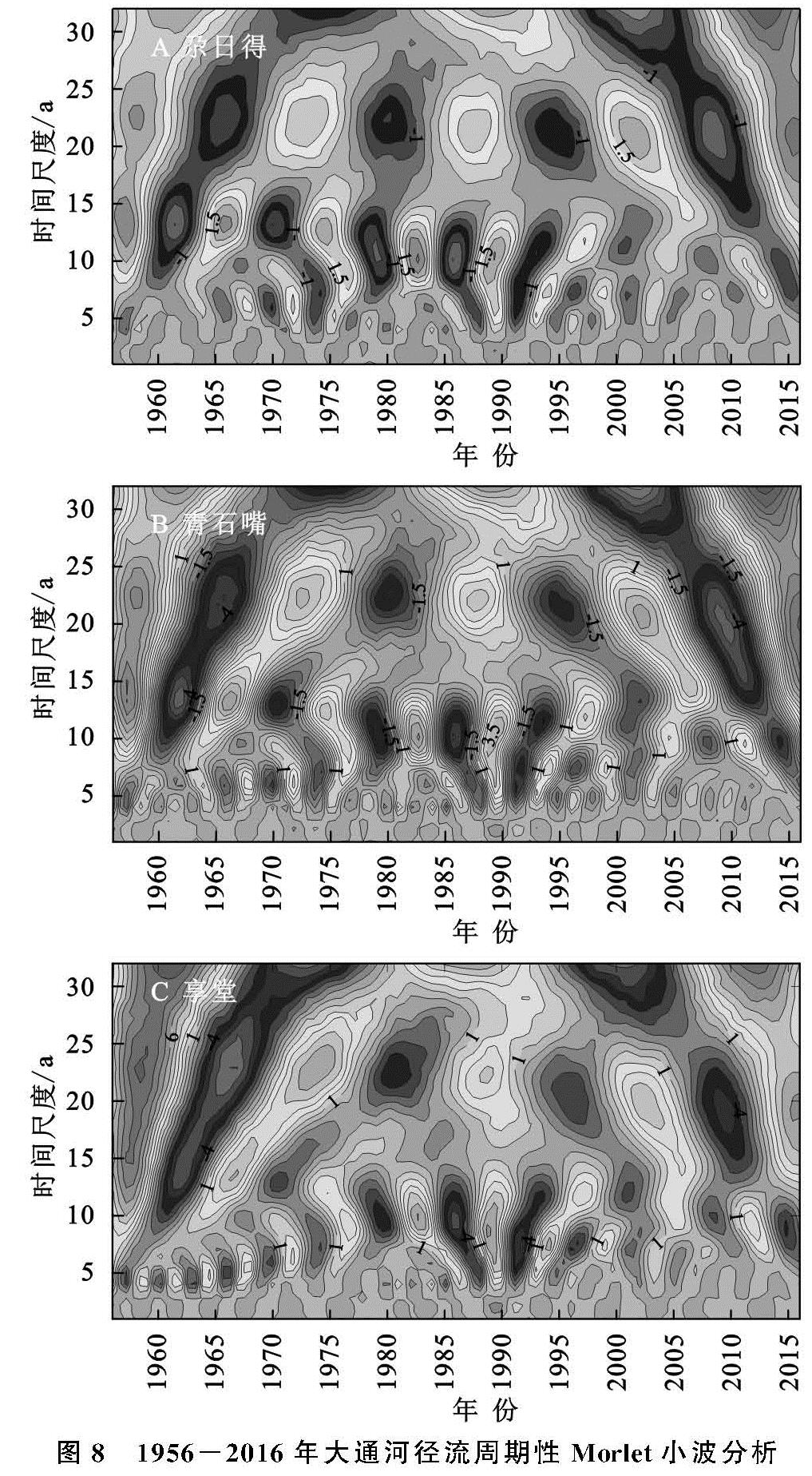
(3)周期变化特征。以大通河尕日得、青石嘴和享堂水文站1956—2016年径流量数据为基础,基于Morlet复小波函数对其年际变化特征进行分析并通过小波方差检验,小波分析结果见图8。
大通河尕日得水文站年净流量存在13 a和22 a尺度的周期震荡,经小波方差检验发现,22 a尺度的周期震荡是其第一主周期,在整个研究时段内经历了4个“丰—枯”转换期; 13 a尺度的周期变化在20世纪90年代以前表现较为强烈,研究时段内经历了6个“丰—枯”转换期。青石嘴水文站存在6 a,10 a和22 a尺度的周期震荡,22 a尺度是其第一主周期,共经历了4个“丰—枯”转换期,在10 a尺度上经历了8个“丰—枯”转换期,在6 a尺度上波动不明显。享堂水文站存在5 a,9 a和22 a尺度的周期变化,经小波方差检验22 a是其第一主周期,在整个研究时段内均有体现,而5 a的周期震荡出现在1970年以前,1970年以后这种周期震荡逐渐被9 a左右的周期震荡所取代。
通过上述分析可知,大通河3个水文站均存在22 a尺度的主周期变化,在此周期内,均经历了4个“丰—枯”交替循环过程。其次,3个水文站中,尕日得水文站的周期变化与气温的周期变化呈现出较好的关系,说明其可能受气温的影响较大; 另外青石嘴和享堂站的周期变化较为复杂,存在多尺度的周期震荡,这可能受其他补给方式及水资源开发利用的影响。
2.3 影响因素
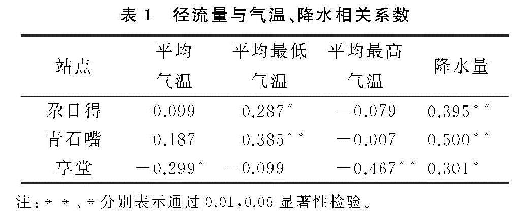
2.3.1 相关性分析 选取大通河尕日得、青石嘴和享堂站1956—2016年径流量数据与同期大通河流域气象数据进行相关性分析(
表1),以揭示气候要素对大通河径流的影响。
由表1可知,尕日得站除平均最高气温外,与其他气候要素呈正相关关系,其中与降水量相关系数最大,为0.395(p<0.01); 青石嘴站与尕日得站相关系数趋同,除平均最高气温外,与其他气候要素呈现出正相关关系,其中与降水量相关系数最大,为0.5(p<0.01),其次为平均最低气温0.385(p<0.01); 享堂站由于跨流域调水等人类活动的影响,径流变化的影响因素较为复杂,与降水量相关系数为0.301(p<0.05),与其他气象要素均为负相关关系。综上可知,大通河3个水文站径流量与降水的相关性较好,这表明降水是大通河径流的主要补给方式,气温通过影响冰雪融水和蒸散发来作用径流量。
图8 1956-2016年大通河径流周期性Morlet小波分析
此外,刘赛艳等
[12]研究认为自20世纪90年代以来,在全球气候变暖的大背景下,大通河河源区雪线的不断上移甚至消失导致了径流量的显著减少; 说明温度对径流变化减小的作用一方面体现在影响冰川积雪的储量来作用径流量,另一方面则是通过影响蒸发作用进而减少径流量,但就其在径流变化中所贡献的程度仍需进一步研究。
2.3.2 人为因素的影响分析 人为因素对大通河流域径流的影响主要来自于两方面,一是跨流域调水引起径流量下降。流域内目前已建成跨流域调水工程3处,分别为1995年“引大入秦”工程,设计引水量4.43亿m3; 2003年“引硫济金”工程,设计引水量0.4亿m3; 2016年“引大济湟”一期工程,设计引水量3.5亿m3。随着生产、生活用水的增加及社会经济的发展,人们对大通河的取水量势必会增加,这也将导致大通河径流量逐年减少。二是流域地表覆被变化也会对径流产生一定的影响,朱丽蓉等人[27]对干旱区的昌化江径流研究发现,大规模经济作物的种植、大型水利工程建设和土壤侵蚀造成的下垫面变化间接导致了昌化江径流量下降; 代晓颖等人[28]通过对秦淮河流域的研究发现随着城市化进程的发展,1987—2013年流域内建设用地大幅度增加,植被覆盖度呈减少趋势,使得其调节径流的功能减弱,洪涝风险增加。总体上来看,大通河流域人类活动对径流的影响主要体现在跨流域调水工程和地表覆被变化两方面。根据相关研究可知[13],大通河流域自20世纪90年代以来,土地利用类型以草地和林地为主,没有发生大的变化,因此地表覆被变化对径流的影响作用较弱,引起大通河径流变化的主要人为因素是跨流域调水工程。