农村居民点作为人类生产生活的重要载体[1-3],伴随着中国改革开放社会经济的飞速发展,在快速城镇化和工业化的扰动下[4],以及城乡二元结构的长期束缚和“重城轻乡”发展战略导向驱使下[5-6],农村居民点用地粗放、功能单一、缺乏规划、空心化、贫困化、环境污染化等一系列“乡村病”日益凸显、越发严重[7]。党的“十九大”审时度势,鲜明指出中国特色社会主义进入新时代,并首次提出“实施乡村振兴战略”,致力于建设“产业兴旺、生态宜居、乡村文明、治理有效、生活富裕”的现代化新农村[6]。乡村振兴,生态宜居是关键,居民点适宜性评价是进行乡村整治、优化重构,改善人居环境的前提基础[8-10]。因此,在新时代实施乡村振兴战略背景下,基于科学、客观的居民点适宜性评价结果,立足区域发展实际、根据资源禀赋因地制宜的探索开展人居环境整治,已成为亟待解决的重点前沿课题。
国际学者针对农村居民点适宜性评价开展了大量研究,取得丰硕成果。总结已有研究,主要呈现以下几方面特点:(1)研究地域多样化。涵盖平原、山地、农区、盆地、少数民族区域和生态经济区,主要有陕西关中平原腹地西安杨陵区[11]、宝鸡市陇县[12]、黑龙江省五常市[13]、山西忻定盆地忻府区[14]、江西省潘阳湖生态经济区潘阳县[15]、西南典型低山丘陵区[16]以及四川盆地震后重建北川羌族自治县[17]、川中丘陵隆昌市[18]、成都平原都江堰市[19];(2)评价指标完善化。在传统的土地适宜性评价指标,例如高程、坡度、坡向等自然因素[19]以及距道路、距城镇等区位因素[16]的基础上,根据评价目标的导向性以及区域的差异性,反映社会经济发展状况的人居可支配收入、人口城镇化率、土地经济密度等因子,以及土地利用类型、生态保护区、人文景观、地质灾害、植被覆盖度等生态环境因素逐渐纳入到评价指标体系中[13-15,20];(3)研究数据多源化。涵盖了中国资源3号卫星、全球MODIS NDVI,Landsat OLI,DEM等遥感影像数据,土地利用现状、国土资源调查及年度变更等土地利用数据,地形图、土壤图、交通道路、河流水系、植被、地质灾害、城乡规划等辅助数据以及统计年鉴等社会经济统计数据[11,13,21-22];(4)评价模型、理论丰富化。在传统的土地资源学土地适宜性评价理论基础上逐渐引入景观生态学、生态位理论[23-24]、AVC三力[20]、“源、汇”景观理论等[25]新理论,评价模型在传统的AHP层次分析法基础上,利用RS遥感影像,基于GIS空间分析,最小积累阻力模型[19]、灰靶模型[26]、生态位适宜度模型[27]、物元模型等[28]模型方法已广泛应用到居民点适宜性评价中。已有研究成果丰富了农村居民点适宜性评价前沿研究,为农村居民点规划、整治、重构,人居环境改善及乡村振兴战略实施提供科学依据。但尚且存在部分问题没有很好的解决,例如评价因子权重赋值人为主观臆断现象。截至目前,评价指标因子选取和因子权重赋值尚无统一规范或标准,主要依靠参与人员或专家经验进行权重赋值,因而由于人员的专业背景、学术经验差异化以及研究区域的独特性,导致因子权重赋值存在较为严重的人为主观臆断现象,进而引发评价结果准确性存在偏差。
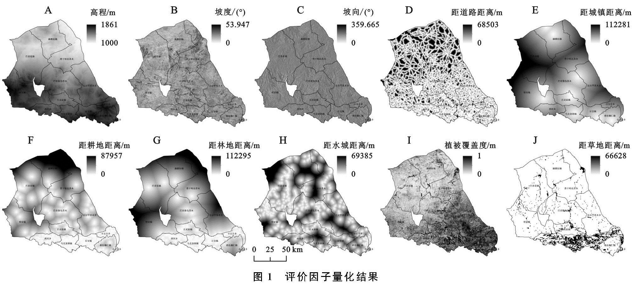
基于数据驱动的机器学习方法可以杜绝人为主观臆断影响。近年来,随着信息科学技术的兴起,使得基于数据驱动的机器学习方法在土地科学领域的土地类型分类[8]、城市扩张[29]、资源生态安全评价[30]、栖息地适宜性评价等[31]方面得到了广泛运用。探讨基于数据驱动的机器学习方法在居民点适宜性评价领域应用的案例成果虽为罕见,但已成为学术前沿研究趋势[8]。因此,本文以生态环境脆弱、少数民族边疆地区的内蒙古包头市达尔罕茂明安联合旗(简称达茂旗)为例,基于数据驱动的机器学习maxEnt模型方法,选取DEM、坡度、坡向自然环境因素,距道路距离、距城镇距离区位条件因素,距耕地距离、距林地距离、距水域距离生产条件因素以及植被覆盖度、距草地距离生态环境因素,对达茂旗居民点空间分布适宜性进行评价研究,进而厘清各因子要素对居民点适宜性影响的重要程度,明晰适宜区居民点与各因子要素的最佳配置关系,以期为该区域居民点优化整治、人居环境改善提供新思路。