3.1 生态源地识别
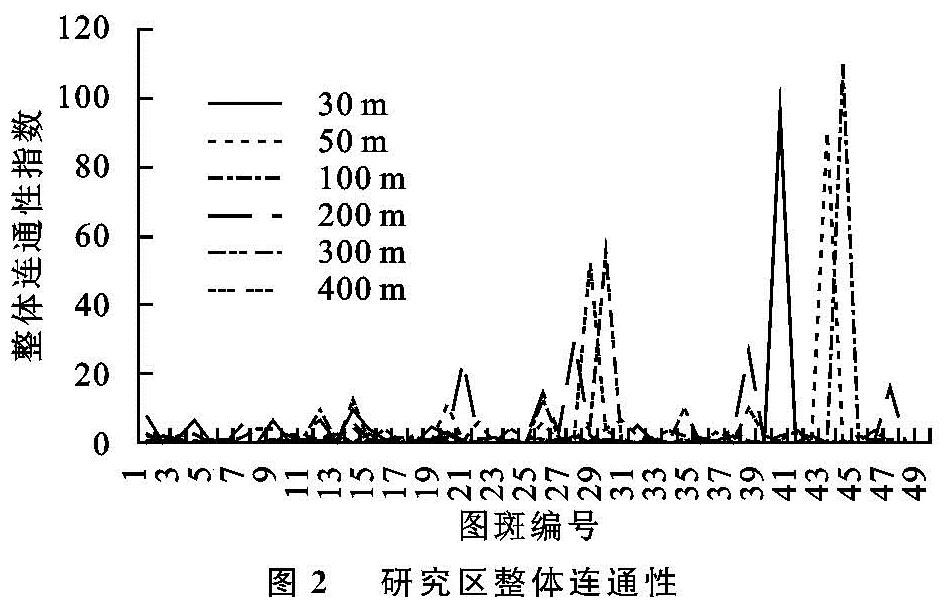
3.1.1 不同粒度水平下的生态源地连通性
生态源地的识别是指提供重要生态系统服务与生态敏感的斑块。针对区域典型生态系统,定量评估生态系统服务的供给能力与生态敏感性,识别生态系统服务供给的重要区域与生态敏感区域,两者叠加可以作为源地识别的有效方法[30]。在识别生态源地之前,需要确定研究区最优生态源地结构,因此根据粒度反推法的原理,从不同粒度水平的整体连通性判断出最优的生态源地结构[31]。从生态系统服务重要性和生态敏感性叠加结果中提取一级生态源地,运用Conefor软件计算30,50,100,200,300,400,500 m共6种不同粒度下生态源地的整体连通性,最终确定最优生态源地结构,其中500 m粒度下融合较多,生态源地数量大幅减少,无法与其他粒度下的源地数量保持一致,故不分析500 m粒度下的生态源地结构,其余选取各粒度下的50个核心区域计算核心区域整体连通性结果见图2。200 m粒度下,整体连通性起伏较大,其余粒度整体连通性较为平缓。不同粒度下生态源地的整体连通性平均值大小随粒度的增加呈抛物线式,其中200 m粒度下生态源地的整体连通性的平均值最大达到峰值,结合核心区域的整体连通性的波动范围确定200 m粒度时连通性最优。
3.1.2 生态源地的确定
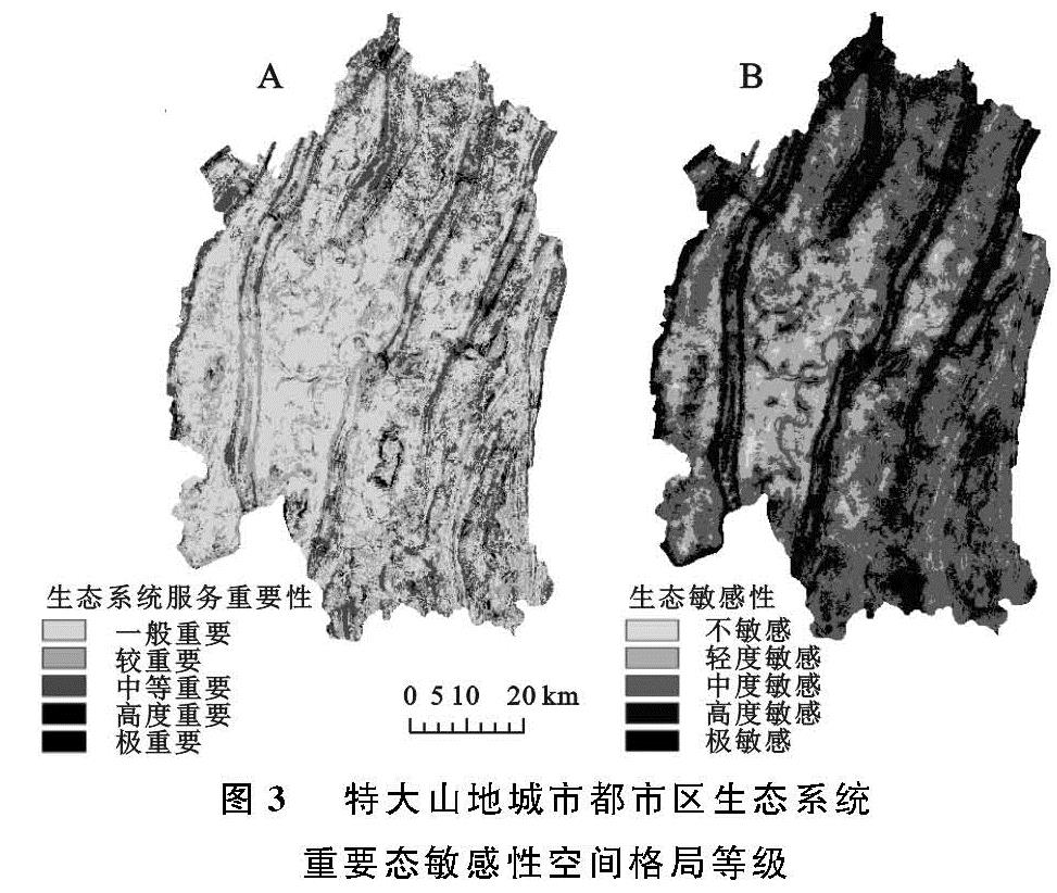
由上述可知200 m粒度是生态源地整体连通性最好的参照,因此,将各数据栅格化,并将栅格大小统一为200 m×200 m。基于研究区水土保持、水源涵养、生境质量3类生态系统服务功能叠加结果形成生态系统服务功能重要性评价结果,运用自然断点法将评价结果划分为极重要区、高等重要区、中等重要区、较重要区、一般重要区,形成重庆市都市区生态系统服务空间格局(图3A),不同级别重要区面积及占比见表2。极重要区域面积22.38 km2,占研究区总面积的0.44%,分散分布于研究区的各山脉处。高度重要区域面积452.53 km2,占研究区总面积的8.33%。中等重要区域与较重要区域面积相差不大,分别为1 843.87,18 677.00 km2,共占研究区总面积的68.29%。一般重要面积1 248.29 km2,占研究区总面积的22.97%。
图3 特大山地城市都市区生态系统重要态敏感性空间格局等级
对坡度、海拔、水域、土地利用类型、植被覆盖度、生态保护区6类生态因子的生态敏感性进行单因子评价,将单因子评价结果叠加形成生态敏感性评价结果,运用自然断点法将评价结果划分为极敏感、高度敏感性、中度敏感、一般敏感、不敏感,形成重庆市都市区生态敏感性空间格局(图3B),不同级别敏感区面积及占比见表2。极敏感区域面积619.97 km2,占研究区总面积的11.41%,分散分布于研究区以坡度大、海拔高的生态保护区的林地范围内。高度敏感区域面积47.35 km2,面积占比最大,占研究区总面积的47.35%。中度敏感区域面积2 035.34 km2,占研究区总面积的37.46%。轻度敏感区域面积较小,为200.55 km2,共占研究区总面积的3.69%。不敏感区域面积最小,为23.95 km2,仅占研究区总面积的0.09%。
由上述分析可知,研究区的生态系统重要性整体较低,生态敏感性整体较高,对研究区生态系统服务重要性与生态因子敏感性的分析结果等权叠加,将研究共计区划分4级区域,1级区域面积最小共计824.69 km2,2,3级区域面积分别为1 375.07,1 217.631 km2,4级区域面积共计2 016.68 km2。在划分出的4级区域中剔除小于10 km2的碎小图斑,最终确定生态源地图斑数为14,面积合计1 616.98 km2,占研究区总面积的29.76%,其空间分布见图4。总体来看研究区单块生态源地面积较大,宽度较宽,形态多以条带状为主,主要沿缙云山、中梁山、南山等山脉分布,呈现六纵空间格局,符合典型的山地城市山脉生态系统服务功能强,生态敏感性高的特点,而山脉之间较平缓的区域,城市发展良好,主要体现城市功能。
3.2 最小累积模型判定的生态阻力面
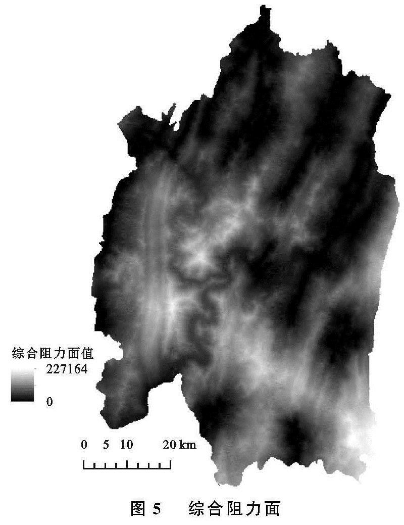
基于特大山地城市都市区的土地利用类型构建生态阻力面,在土地利用类型上反映出城市的建设用地对生态阻力值最大,水体的生态阻力值最低。在空间上阻力面的分布是以组团的形式存在,被区域内其他阻力值较低的土地利用类型所分割; 基于坡度和起伏度的生态阻力面构建,起伏度生态阻力值与坡度的生态阻力值的空间分布特征一致,在空间分布上阻力值较大的区域成条带状分布,特大山地城市都市区的起伏度生态阻力值大小空间分布上呈现由西到东生态阻力值由最低值增加再降低的变化规律; 坡度生态阻力值在空间分布上呈现出由西到东先增加后降低的变化规律,其中在城市建设区内坡度和起伏度的生态阻力值较低。运用最小累积模型形成综合阻力面(图5),在空间分布上综合生态阻力值差异明显,高阻力值集中在研究区的中部、东部和东南部,在研究区的北部和东北部阻力值最低。
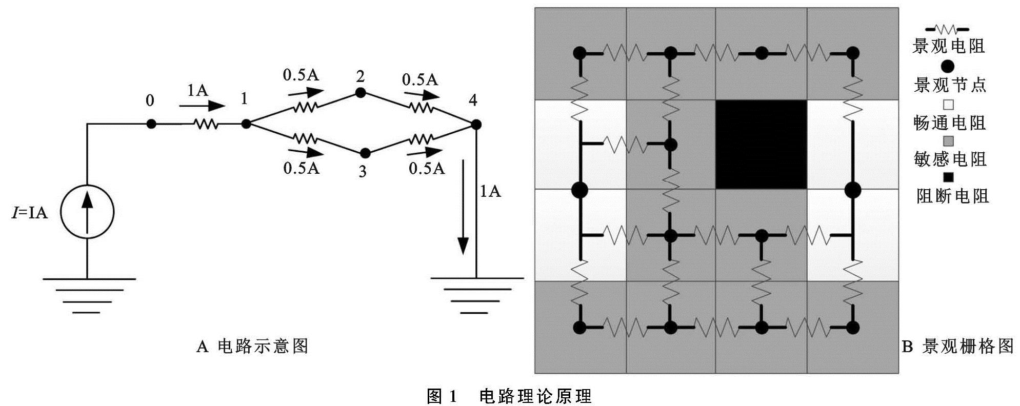
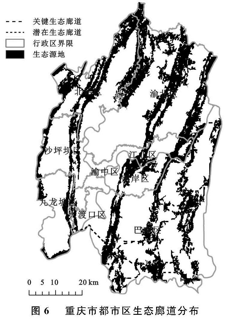
3.3 基于电路理论的生态廊道识别与生态安全格局构建
生态廊道通过连接不同生态斑块,增加区域景观连通性和获取生态效益,是维护区域生态安全的基本骨架[32]。基于生态源地与生态阻力面,结合电路理论结果(表3),对重庆市都市区生态廊道进行识别(图6)。结合电路理论识别出活跃和非活跃的生态廊道。
从生态廊道数量特征上看,由于重庆市都市区生态源地较为破碎,生态阻力大,因此呈现出短小的特点。连接14块生态源地有29条生态廊道,关键廊道22条,总长度约为50.83 km,潜在廊道7条,总长度约为108.21 km。关键廊道中,大于1 km的廊道共12条,长度为46.69 km,是源地之间连接的主要廊道。潜在廊道中,大于10 km的廊道共5条,长度为95.05 km。部分关键廊道和潜在廊道在某些位置重合,可能是因该区域斑块阻力值较小导致[31]。
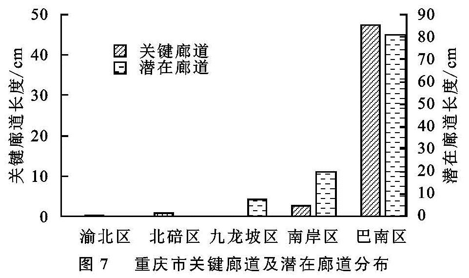
从生态廊道空间分布来看,结合图7研究区各下辖区关键和潜在廊道长度柱状图,关键廊道分布在渝北区、北碚区、南岸区及巴南区,其长度分别占关键廊道总长度的0.35%,1.50%,5.04%,93.11%。潜在廊道分布在九龙坡区、南岸区及巴南区,其长度分别占潜在廊道总长度的6.8%,18.19%,75.01%。
从图7可以看出,研究区西部和北部仅存在一条关键廊道,主要是因为位处缙云山、中梁山和龙王洞山的生态源地横跨7个重庆市下辖区域,三者之间形成了一条宽阔的带状生态源地,宽度大、面积大的特点使其面临的生态压力相对较低。同时,由于巴南区生态源地数量多、较为破碎,因此绝大部分的关键廊道和潜在廊道主要分布在重庆市巴南区南部,并且由该区域向外发散至整个研究区。
生态安全格局是对区域生态空间进行国土空间格局优化的空间配置方案,由一系列功能各异、相对独立的景观单元结合生态廊道构成,对维护景观格局整体性及区域生态安全具有重要意义[33]。以生态源地作为缓冲区面要素,根据每个生态源地的面积大小,分别设置1,2,3 km等不同宽度的缓冲区作为生态源地的辐射区(图8)。经统计,现有生态源地的辐射面积为4 543.92 km2,达到研究区总面积的83.32%。现状生态源地辐射未覆盖区域除了分布在研究区边缘,在研究区中部和南部也存在较大范围的未覆盖区。
基于对重庆市都市区生态源地、关键廊道和潜在廊道的分析,本文提出构建“一圈两带两中心”生态安全格局。其中,“一圈”指研究区所形成的都市生态圈,“两带”指研究区生态源地未辐射的生态提升带,“两中心”指以巴南区东南部向北散射的廊道中心与研究区北部向南散射的生态源地中心。生态提升带需要重点新增生态源地,加快绿色基础设施建设,控制城市开发边界,高效利用城市生产、生活空间,保护生态空间范围,以优化城市生态安全结构。生态源地中心林业资源丰富,可发展旅游业、绿色产业,为研究区提供水源涵养、土壤保持等多种服务功能。廊道中心主要承担物种迁移的传输通道、生物生存繁殖的生境等基础功能[25],物质流动频繁,需加强生态保护,保证都市生态圈的生态过程的畅通性。