2.1.1 乡村聚落数量与面积演变特征
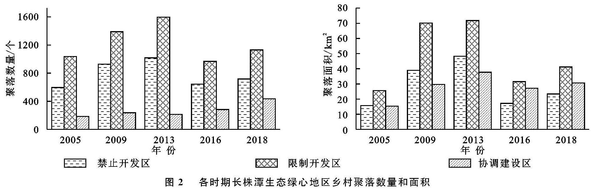
利用ArcGIS软件分别从2005年、2009年、2013年、2016年和2018年土地利用数据中提取乡村聚落用地,依据《规划》中土地用途管制分区,选取数量、面积两个参数对长株潭生态绿心地区乡村聚落进行对比统计分析,结果见图2。
图2表明,2005—2018年,长株潭生态绿心地区乡村聚落数量和面积总体呈现先增加—后减少—再增加的变化趋势,转折点分别为2013年和2016年。2005年,禁止开发区、限制开发区和协调建设区内乡村聚落数量分别为596个、1 037个和183个,聚落面积分别为15.66 km2,25.60 km2,15.25 km2,其中限制开发区乡村聚落数量和面积最大,协调建设区乡村聚落数量和面积最小,但限制开发区和协调建设区单位聚落面积分别为0.025 km2,0.083 km2,由此推测乡村聚落在限制开发区呈现多而散的分布,在协调建设区呈现少而聚的分布特征。2005—2013年,禁止开发区、限制开发区和协调建设区内乡村聚落数量分别新增421个、560个和30个,增长幅度为70.64%,54.00%和16.40%,乡村聚落面积分别增长32.49 km2,46.16 km2,22.49 km2,增长幅度为207.47%,180.31%和147.48%。生态绿心地区土地用途管制政策实施前,乡村聚落多集聚在禁止开发区和限制开发区内,具有显著的生态环境指向性,随着基础服务设施不断完善,乡村聚落数量和面积的急剧增长对生态绿心地区的生态保护带来巨大挑战。随着2013年《规划》的颁布实施,生态绿心地区的乡村聚落施行严格的土地用途管制,乡村聚落空间结构发生剧变。2013—2016年,禁止开发区和限制开发区内乡村聚落数量分别减少374个和629个,减少比例为36.78%和39.39%,协调建设区乡村聚落数量增加70个,增长幅度为32.86%,禁止开发区和限制开发区内的乡村聚落向协调建设区内大量迁移可能是造成聚落数量剧变的主要因素之一。而禁止开发区、限制开发区和协调建设区的乡村聚落面积较2013年分别减少30.91 km2,40.30 km2,10.69 km2,减少比例分别为64.20%,56.16%和28.33%,大量空心村落拆并整合,且部分城镇周边的乡村聚落被就地划为城镇建设用地可能是导致生态绿心地区乡村聚落面积整体减少的主要原因。土地用途管制有效限制了禁止开发区和限制开发区内乡村聚落的发展,降低了人为活动对生态环境的破坏。2016年后,随着生态旅游与康养产业的开发建设,生态绿心地区乡村聚落数量和面积再次呈现增长趋势。2018年,禁止开发区、限制开发区和协调建设区内乡村聚落数量较2016年分别增加73个、162个和151个,增长幅度为11.35%,16.74%和53.36%; 乡村聚落面积分别增长6.15 km2,9.73 km2,3.61 km2,增长幅度为35.67%,30.93%和13.35%,土地用途管制下生态绿心地区的禁止开发区和限制开发区内乡村聚落数量和面积呈现上升趋势,随着年限的增长,管控力度有所减弱。为更清晰地展示乡村聚落在生态绿心地区的分布情况,结合最近邻分析法与核密度估计法对乡村聚落的分布特征进行研究。
2.1.2 乡村聚落空间演变特征
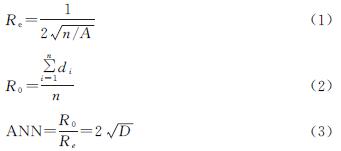
运用最近邻分析法,测算2005年、2009年、2013年、2016年、2018年长株潭城市生态绿心地区乡村聚落点,结果见表2。
2005年、2009年、2013年、2016年、2018年生态绿心地区乡村聚落ANN均小于1,且p=0时标准化Z值均小于1.96,表明研究区聚落分布态势与随机模式差异较为显著,在一定因素作用下呈集聚分布特征。2005—2018年间乡村聚落点的ANN先增长后降低,表明集聚程度先减少后增加。
运用核密度估计法对乡村聚落密度进行测算,生成各时期长株潭生态绿心地区乡村聚落核密度分布图(图3A—E)。2005年,核密度较大乡村聚落主要在生态绿心地区北部的限制开发区内集聚,核密度为10~15个/km2。2009年,乡村聚落核密度总体增幅较大,这一结果与图2中聚落数量和面积有较大幅度增长的结果相一致; 分布模式也略有改变,在生态绿心地区西部的禁止开发区和东南部的限制开发区内出现新的乡村聚落集聚点,呈现均匀核心集聚模式。2013年,乡村聚落整体呈现多核心集聚模式,尤其在北部、东南部的限制开发区和西部的禁止开发区内形成较大集聚核心,核密度达到25~30个/km2,且集聚分布开始向禁止开发区内蔓延。随着2013年《规划》的颁布实施,乡村聚落的集聚模式开始发生转变。2016年,乡村聚落集聚核心减少,乡村聚落核密度在北部、东南部的限制开发区和西部的禁止开发区内急剧下降,在协调建设区内保持稳定。2018年,乡村聚落沿协调建设区集聚程度显著加深,集聚模式由均匀式核心集聚转变为集中式高密度核心集聚,在研究区西部沿协调建设区一线形成两个大的集聚核心,核密度达到35~40个/km2,与协调建设区相邻的禁止开发区内乡村聚落集聚程度也有所增加。土地用途管制政策实施前,长株潭生态绿心地区乡村聚落主要在生态环境优异的禁止开发区和限制开发区集聚,土地用途管制政策实施后,乡村聚落开始向协调建设区内迁移、集聚,但随着管制年限的增长,协调建设区沿线周边的禁止开发区和限制开发区乡村聚落核密度也存在一定程度的增长。
2.2 乡村聚落空间分布统计分析
2.2.1 基于道路因素乡村聚落空间分布统计分析
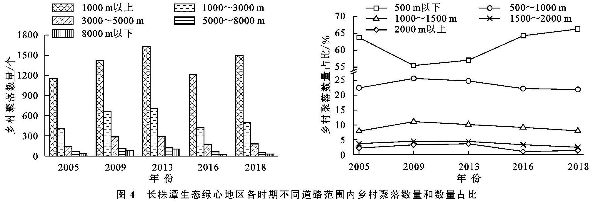
乡村道路作为乡村聚落物质流和信息流的传递通道,乡村聚落距离乡村道路的远近是影响乡村聚落演变的重要因素之一。利用ArcGIS软件对长株潭生态绿心地区乡村道路以500 m为梯度进行多层缓冲区处理,将所得结果与各时期乡村聚落分布进行叠加,统计各时期不同道路范围内乡村聚落数量和数量占比。
图4显示,各时期距道路500 m范围内乡村聚落数量最多,且乡村聚落数量随距道路距离增加而持续减少,表明长株潭乡村聚落分布具有明显的道路交通指向性。2005年,距道路500 m以下、500~1 000 m,1 000~1 500 m,1 500~2 000 m和2 000 m以上的乡村聚落数量分别为1 151,405,143,67,40个,数量占比分别为63.73%,22.43%,7.92%,3.71%和2.21%,乡村聚落多选址于距道路较近区域。2009年,随着乡村居民生活水平的提高,人们开始选择生态环境更优异的区域作为聚落点,距道路500 m以下、500~1 000 m,1 000~1 500 m,1 500~2 000 m和2 000 m以上的乡村聚落数量分别为1 424,658,285,116,85个,距道路500 m以下乡村聚落数量增长量最多,但1 000~1 500 m,1 500~2 000 m和2 000 m以上的乡村聚落数量与2005年数据比较都呈现倍数增长。2009年,国家发改委批复了《长株潭城市群城际轨道交通网规划(2009—2020年)》,道路交通对聚落分布的影响力度增大。2009—2013年,距道路1 000 m以上区域乡村聚落点保持稳定,仅距道路1 000 m区域内乡村聚落数量有所增长。2013年《规划》实施后,各距离范围内尤其是距道路距离较远的乡村聚落数量显著降低,至2016年,距道路500 m以下、500~1 000 m,1 000~1 500 m,1 500~2 000 m和2 000 m以上的乡村聚落数量分别为1 216,420,173,63,20个,与2013年相比,各距离乡村聚落数量占比分别降低25.17%,40.51%,39.93%,50.00%和80.77%,造成这一现象可能是由于距道路较远的乡村聚落大多分布于禁止开发区和限制开发区内,而土地用途管制限制乡村聚落在其区域内的发展。2018年,乡村聚落数量仅在距道路500 m以内时有较为显著增长。土地用途管制有效限制了禁止开发区和限制开发区乡村聚落的发展,但对乡村聚落沿道路的总体分布特征影响较小。
图4 长株潭生态绿心地区各时期不同道路范围内乡村聚落数量和数量占比
2.2.2 基于乡镇辐射因素乡村聚落空间分布统计分析
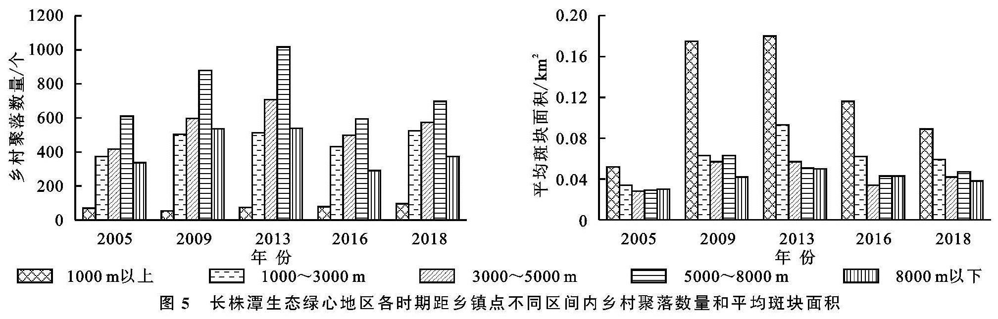
乡镇的辐射作用也是影响乡村聚落发展、演变的重要因素之一,对长株潭生态绿心地区乡村聚落到乡镇点距离划分为1 000 m以下、1 000~3 000 m,3 000~5 000 m,5 000~8 000 m,8 000 m以上共5个区间进行多层缓冲区分析,将研究结果与乡村聚落分布图叠加,统计各时期距乡镇点不同区间内乡村聚落数量和平均斑块面积。
图5显示2005—2018年长株潭生态绿心地区乡村聚落在距乡镇点1 000 m范围内数量最小,但聚落的平均斑块面积最大。2005年,距乡镇点1 000 m以下、1 000~3 000 m,3 000~5 000 m,5 000~8 000 m及8 000 m以上的乡村聚落数量分别为69,373,417,610,337个,平均斑块面积为0.052,0.034,0.028,0.029,0.030 km2。2005—2009年、1 000 m以内的乡村聚落数量下降21.74%,而平均斑块面积增加了236.54%,出现了乡村聚落的统筹整合,其他各距离段乡村聚落数量和平均斑块面积也都出现了增长趋势。2009—2013年、1 000 m以下、5 000~8 000 m及8 000 m以上3个距离段的乡村聚落数量平均斑块面积基本保持不变,1 000~3 000 m和3 000~5 000 m两个距离段的乡村聚落数量持续增长,图3中也可以显著看出,乡村聚落数量的增长主要发生在禁止开发区和限制开发区内。2013年《规划》实施促进了聚落统筹发展,2013—2016年,距乡镇点1 000 m以外距离段,尤其是禁止开发区和限制开发区内的乡村聚落数量和面积显著降低,《规划》中要求强化小城镇辐射职能,依托小城镇道路网体系进行点轴式发展的乡村居民点空间结构得到体现。2016—2018年,各距离段乡村聚落数量都有所增长,平均斑块面积略有降低,对比2016年,呈现出多而散的空间布局,与《规划》的建设目标有所偏差。土地用途管制前后,乡村聚落数量和平均斑块面积在各距离段所占比例基本保持稳定,对乡村聚落分布的乡镇点区位因素影响较小。
图5 长株潭生态绿心地区各时期距乡镇点不同区间内乡村聚落数量和平均斑块面积
2.3 讨 论
2005—2013年乡村聚落数量及面积逐年递增,受自然环境因素影响乡村聚落的分布具有明显的环境指向性,多在生态环境优越的禁止开发区及限制开发区内集聚。随着《规划》的颁布,2013—2016年,乡村聚落数量及面积均开始下降,且集聚的核心按照《规划》的要求迅速向协调建设区内迁移生态绿心区的管控达到了既定目标。但随着管控年限的增长,2016—2018年,长株潭生态绿心地区的禁止开发区和限制开发区内,乡村聚落数量呈现增长趋势,空间管制效力随着年限的增长而逐渐减弱,可能由以下原因导致:
(1)长株潭生态绿心地区的土地用途管制是典型的依据土地自然资源要素的管制,其中对建设用地、耕地和林地要素的管控指标较为完善,而针对水系和湿地要素管控的边界较为模糊。2016年后,随着管控年限的增长,管控效果出现了一定偏差,政府未能制定保障管控政策实施的配套补偿措施可能是导致后期管控不力的主要原因。为此,2018年湖南省政府根据长株潭生态绿心地区土地利用现状对《规划》进行了修订,文件中调整了生态绿心地区各空间管制范围,并补充了“五线”保护与控制引导办法,目前,办法尚未在空间上进行落实。后续若能结合该地区乡村聚落空间格局演变规律,制定配套的补偿措施,有望更好地落实相关管控政策。
(2)生态绿心地区土地用途管制的核心是对区域内生态空间的管制,即对区域内空间土地资源在生产、生活、生态三方面的再分配过程。在演变的过程中,受利益驱动影响,区域内居民会择优而居,在一定程度上会影响整体的空间布局模式。长株潭生态绿心地区在管制过程中实施传统的许可管制方案而缺乏全过程的监测管制。若通过持续监测聚落空间变化,理清区域内人地关系的发展趋势,能够切实保障政策执行,实现人与自然的协调可持续发展。

 (4)
(4)