3.1 水土流失量分析
依据岩溶生态系统水土流失估算模型和各因子计算获取方法,计算广西岩溶生态系统水土流失总量,按照水利部颁布的《岩溶地区水土流失综合治理技术标准》(SL461—2009)进行水蚀强度分级。广西岩溶生态系统土壤侵蚀强度等级见图1。
广西岩溶生态系统平均土壤侵蚀模数为560.21 t/(km2·a),土壤侵蚀总量为3 691.06万 t/a。从侵蚀强度看,中度及以上土壤侵蚀量较大,土壤侵蚀模数分别为1 572.74万 t/a,826.49万 t/a,530.65万 t/a,394.08 t/a,所占岩溶区土壤侵蚀总量比例分别为42.61%,22.39%,14.38%,10.55%; 微度土壤侵蚀量最小,为14.74万t/a,仅占岩溶区土壤侵蚀总量比例为0.40%。从侵蚀面积上看,微度、轻度、中度土壤侵蚀面积较大,土壤侵蚀面积分别为15 539.25,24 595.13,19 877.68 km2,所占岩溶区总面积比例分别为23.58%,37.33%,30.17%; 剧烈土壤侵蚀面积最小,为433.44 km2,占岩溶区总面积比例为0.66%。
3.2 水土流失关键指标影响分析
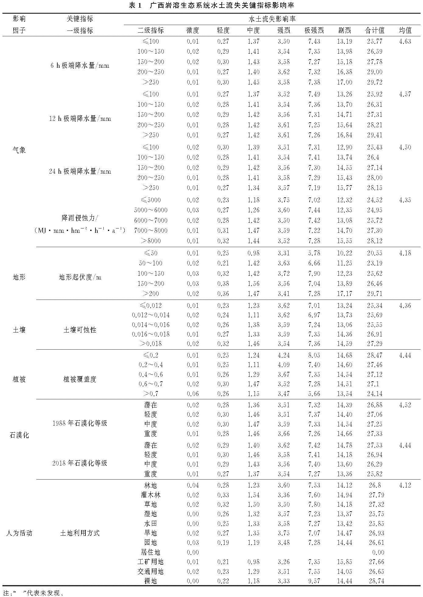
广西岩溶区水土流失的形成和发生是一个极其复杂的过程,从影响因素来看,是气象、地形、土壤、植被、石漠化、工程措施等多种因子综合作用的结果。气象因子根据广西不同时段极端降水事件[45]、降雨侵蚀力[46]的时空分布特征,将6,12,24 h极端降水量指标分5级:≤100 mm,100~150 mm,150~200 mm,200~250 mm,>250 mm; 将降雨侵蚀力指标分5级:≤5 000 MJ·mm/(hm2·h·a),5 000~6 000 MJ·mm/(hm2·h·a),6 000~7 000 MJ·mm/(hm2·h·a),7 000~8 000 MJ·mm/(hm2·h·a),>8 000 MJ·mm/(hm2·h·a)。地形、土壤、植被因子按照《生态保护红线划定指南》结合广西实际情况分级,其中,地形起伏度指标分5级:≤50 m,50~100 m,100~150 m,150~200 m,>200 m; 土壤可蚀性指标分5级:≤0.012,0.012~0.014,0.014~0.016,0.016~0.018,>0.018; 植被覆盖度指标分5级:≤0.2,0.2~0.4,0.4~0.6,0.6~0.7,>0.7。石漠化因子则根据广西石漠化等级数据划分为:潜在、轻度、中度、重度。人类活动因子根据土地利用方式划分为:林地、灌木林、草地、湿地、水田、旱地、园地、居住地、工矿用地、交通用地、裸地。采用岩溶生态系统水土流失关键因子影响评价模型,计算广西不同影响因子等级对不同土壤侵蚀强度的影响率(表1)。
从气象因子看,气象条件对土壤侵蚀的影响表现为:6 h极端降水量影响率均值(4.63)>12 h极端降水量影响率均值(4.57)>24 h极端降水量影响率均值(4.50)>降雨侵蚀力影响率均值(4.35); 降水量各等级指标对土壤侵蚀的影响随土壤侵蚀强度均呈递增趋势,其中,极端降水量(>250 mm)和降雨侵蚀力[>8 000 MJ·mm/(hm2·h·a)]对土壤侵蚀量的总影响率最大,6,12,24 h极端降水量的总影响率分别为29.72,29.41,28.15,降雨侵蚀力的总影响率为28.12; 气象条件各等级指标对土壤侵蚀中度及以下的影响随降水量的增加基本不变,而强烈及以上的影响随降水量的增加呈递增趋势,其中,极端降水量(>250 mm)和降雨侵蚀力[>8 000 MJ·mm/(hm2·h·a)]的剧烈侵蚀对土壤侵蚀的影响最大,6,12,24 h极端降水量的影响率分别为17.00,16.84,15.77,降雨侵蚀力的影响率为15.55。
从地形因子看,地形起伏度对土壤侵蚀的影响表现为:地形起伏度各等级指标对土壤侵蚀的影响随土壤侵蚀强度均呈递增趋势,其中,地形起伏度(>200 m)对土壤侵蚀量的影响率最大,影响率合计为29.71; 地形起伏度各等级指标对土壤侵蚀各强度的影响随地形起伏度的增加呈增加趋势,其中,地形起伏度(>200 m)的剧烈侵蚀对土壤侵蚀的影响最大,影响率为17.17,地形起伏度(150~200 m)的剧烈侵蚀次之,影响率为13.89,地形起伏度(<150 m),影响率差别不大。
从土壤因子看,土壤可蚀性对土壤侵蚀的影响表现为:土壤可蚀性各等级指标对土壤侵蚀的影响随土壤侵蚀强度均呈递增趋势,其中,土壤可蚀性(>0.018)对土壤侵蚀量的影响率最大,影响率合计为27.29; 土壤可蚀性各等级指标对土壤侵蚀各强度的影响,除强烈侵蚀随土壤可蚀性的增加呈递减趋势,其余侵蚀等级呈增加趋势,其中,土壤可蚀性(>0.018)的剧烈侵蚀对土壤侵蚀的影响最大,影响率为14.59,土壤可蚀性(0.016~0.018)的剧烈侵蚀次之,影响率为14.36,土壤可蚀性(<0.016),影响率差别不大。
从植被因子看,植被覆盖度对土壤侵蚀的影响表现为:植被覆盖度各等级指标对土壤侵蚀的影响随土壤侵蚀强度均呈递增趋势,其中,植被覆盖度(≤0.2)对土壤侵蚀量的影响率最大,影响率合计为28.47; 植被覆盖度各等级指标对土壤侵蚀中度及以下的影响随植被覆盖的增加呈增加趋势,而强烈及以上的影响随植被覆盖度的增加呈递减趋势,其中,植被覆盖度(≤0.2)的剧烈侵蚀对土壤侵蚀的影响最大,影响率为14.68,植被覆盖度(0.2~0.4)的剧烈侵蚀次之,影响率为14.60,植被覆盖度(>0.4),影响率差别不大。
从石漠化因子看,石漠化等级对土壤侵蚀的影响表现为:1988年石漠化等级影响率均值(4.52)>2018年石漠化等级影响率均值(4.44); 1988年、2018年石漠化等级指标对土壤侵蚀的影响均随土壤侵蚀强度呈递增趋势,其中,1988年重度石漠化等级对土壤侵蚀量的影响率最大,影响率合计分别为27.33,2018年潜在石漠化等级对土壤侵蚀量的影响率最大,影响率合计分别为27.53; 1988年石漠化各等级指标对土壤侵蚀中度及以下的影响随石漠化强度的增加变化不大,而强烈及以上的影响随石漠化强度的增加呈递增趋势,其中,重度石漠化等级的剧烈侵蚀对土壤侵蚀的影响最大,影响率为14.66,2018年石漠化各等级指标对土壤侵蚀中度及以下的影响随石漠化强度的增加变化也不大,而强烈及以上的影响随石漠化强度的增加呈递减趋势,其中,潜在石漠化等级的剧烈侵蚀对土壤侵蚀的影响最大,影响率为14.78。
从人类活动因子看,土地利用方式对土壤侵蚀的影响表现为:工矿用地的剧烈侵蚀对土壤侵蚀的影响最大,影响率为15.85,灌木林的剧烈侵蚀次之,影响率为14.94,之后旱地、裸地的剧烈侵蚀,影响率分别为14.47,14.44。
从综合因子看,各影响因子指标对土壤侵蚀的影响表现为:因子影响率,气象(4.51)>石漠化(4.48)>植被(4.44)>土壤(4.36)>地形(4.18)>人类活动(4.12); 指标影响率,6 h极端降水量(>250 mm)影响率最大,为29.72,其次为地形起伏度(>200 m),为29.71,之后为12 h极端降水量(>250 mm),为29.00,地形起伏度(≤50 m)影响率最小,为20.55; 等级强度影响率,地形起伏度(>200 m)的剧烈侵蚀影响最大,为17.17,6 h极端降水量(>250 mm)的剧烈侵蚀次之,为17.00,之后为12 h极端降水量(>250 mm)的剧烈侵蚀,为16.84。
3.3 水土流失敏感性评估指标体系构建
岩溶生态系统水土流失在岩溶背景环境和人类活动的影响下,造成了土壤量流失和土壤质量下降。岩溶环境的脆弱性和人为的破坏性,决定了岩溶生态系统水土流失的敏感性。基于岩溶生态系统水土流失关键指标影响评价,从自然和人为因素,考虑选取降水量、地形起伏度、土壤可蚀性、植被覆盖度、石漠化演变趋势、土地利用方式等为评估指标,构建广西岩溶生态系统水土流失敏感性指标体系(表2)。
根据岩溶水土流失关键指标影响评价,将各因子对水土流失敏感性划分为不敏感、轻度敏感、中度敏感、高度敏感、极敏感,规定量值从1—9敏感性依次增加,获得广西岩溶生态系统水土流失敏感性指数值。从气象影响因子可知,水土流失量与高强度、大暴雨、特大暴雨等大侵蚀降水量密切关系,降水强度越高、降水总量越大,其水土流失量越大,水土流失敏感性越高。从石漠化影响因子可知,不同阶段石漠化等级对水土流失的敏感性呈现出较大差异。在石漠化形成初级,岩溶区还有土地覆盖,即“有土可流”,此时水土流失量随石漠化等级强度呈递增趋势。石漠化等级越高,水土流失敏感性越高。在石漠化扩张阶段,岩溶区已基本无土地覆盖,即“无土可流”,此时水土流失量随石漠化等级强度呈递减趋势。但这并不表明石漠化等级强度越高,水土流失敏感性越低。因此,可以采用石漠化演变趋势作为石漠化因子对水土流失敏感性评价指标。石漠化演变趋势变得越差,水土流失敏感性越高。基于GIS技术,将不同阶段的石漠化等级进行空间叠加,分析石漠化演变趋势,划分为变好、变较好、不变、变较差、变差5个等级,其中,变好:轻度变潜在、中度变潜在、重度变潜在; 变较好:中度变轻度、重度变轻度、重度变中度; 不变:潜在变潜在、轻度变轻度、中度变中度、重度变重度; 变较差:潜在变轻度、潜在变中度、轻度变中度; 变差:潜在变重度、轻度变重度、中度变重度。人类活动对水土流失的影响主要体现在土地利用方式的变化。土地利用方式越不合理越容易造成水土流失。根据土地利用方式对土壤侵蚀的影响率,将湿地、居住地划分为不敏感区; 林地、灌木林地为轻度敏感区; 草地和水田为中度敏感区; 旱地、园地为高度敏感区; 交通用地、工矿用地和裸地为极敏感区。
3.4 水土流失敏感性评估模型及对比分析
基于岩溶生态系统水土流失敏感性指标体系,耦合气象、地形、土壤、植被、土地利用方式等自然因素和人为因素对水土流失敏感性的相互影响作用,建立广西岩溶生态系统水土流失敏感性评估模型。
3.4.1 基于GIS叠加分析法的水土流失敏感性评价模型
考虑选择降雨侵蚀力、土壤可蚀性、地形起伏度、植被覆盖度、土地利用方式,采用GIS叠加分析法,建立广西岩溶生态系统水土流失敏感性评估模型,公式如下:
CMSEI=(R1·K1·T1·C1·P1)5(8)
式中:CMSEI为水土流失敏感性指数; R1,K1,T1,C1,P1分别为降雨侵蚀力、土壤可蚀性、地形起伏度、植被覆盖度、土地利用方式敏感性等级值。
3.4.2 基于层次分析法的水土流失敏感性评价模型
考虑选择极端降水事件、土壤可蚀性、地形起伏度、植被覆盖度、石漠化演变趋势、土地利用方式为评估指标,采用层次分析法,基于1—9标度法,通过两两对比判定水土流失敏感性指标的重要性,建立广西岩溶生态系统水土流失敏感性指标矩阵(表3)。
通过判断矩阵计算最大特征根λmax为6.120 5,特征向量为(2.345 7,0.395 2,0.620 6,0.936 8,1.537 2,0.276 0),CR=0.019(<0.1),满足一致性检验,归一化得权重为(0.382 9,0.064 5,0.101 4,0.153 4,0.253 1,0.044 7)。采用加权综合评价法,建立广西岩溶生态系统水土流失敏感性评估模型,公式如下:
AHPEI=0.3829R2+0.0645T1+0.1014K1+0.1534C1+0.2531M1+0.0447P1(9)
式中:AHPEI为水土流失敏感性指数; R2为极端降水量; M1为石漠化演变趋势。
3.4.3 基于空间主成分分析的水土流失敏感性评价模型
同样考虑选择极端降水事件、土壤可蚀性、地形起伏度、植被覆盖度、石漠化演变趋势、土地利用方式为评估指标,采用空间主成分分析法进行指标集成(表4)。
表4 广西岩溶生态系统水土流失敏感性指标主成分分析
空间主成分分析结果显示,按照结果选取前4个主成分即可达到主成分分析85%累计贡献率的统计要求,选取前5个主成分即可达到对整体评价的98.64%贡献,说明前5个主成分已经能够很好地反映岩溶区水土流失敏感性状况。进一步分析各主成分,第1主成分的贡献率为43.29%,在土壤可蚀性上的特征向量值较大,可以概括为土壤敏感性因子; 第2主成分的贡献为20.92%,在石漠化演变趋势上的特征向量值较大,概括为石漠化敏感性因子; 第3主成分的贡献率为19.18%,在地形起伏度上的特征向量值较大,概括为地形敏感性因子; 第4主成分的贡献率为9.47%,在土地利用方式上的特征向量值较大,概括为人为活动敏感性因子; 第5主成分的贡献率为5.78%,在极端降水事件上特征向量值较大,概括为气象敏感性因子。综合考虑各个主成分的贡献因子,地形、土壤、石漠化、气象、人为活动5个因子是影响岩溶区水土流失的主要因素,这与研究区的实际也是相符的。根据空间主成分分析结果,建立广西岩溶水土流失敏感性评估模型,公式如下:
PCAEI=0.4329PC1+0.2092PC2+0.1918PC3+0.0947PC4+0.0578PC5(10)
式中:PCAEI为水土流失敏感性指数; PC1,PC2,PC3,PC4,PC5分别为第1—5主成分。
3.4.4 模型对比分析
根据岩溶生态系统水土流失敏感性评估模型,采用GIS技术,获得空间分辨率为250 m的广西岩溶生态系统敏感性综合指数分布,并利用自然断点法将广西岩溶生态系统水土流失敏感性划分为不敏感、轻度敏感、中度敏感、高度敏感和极敏感5级敏感区。为进一步验证评估模型研究结果的合理性,根据水土流失遥感监测数据,采用基于GIS的信息量法,计算广西岩溶区水土流失敏感性等级信息量(表5)。
表5 广西岩溶生态系统水土流失敏感性评估模型验证对比分析
验证对比结果显示,广西岩溶生态系统水土流失敏感性信息量均随敏感性等级强度的增强而增加; 进一步分析各敏感性等级强度信息量,CMSEI模型的高度及以上敏感性等级信息量为正值,而AHPEI模型和PCAEI模型的中度及以上敏感性等级信息量为正值,说明AHPEI模型和PCAEI模型的敏感性评价优于CMSEI模型; PCAEI模型的中度及以上敏感性等级信息量均大于AHPEI模型的中度及以上敏感性等级信息量,且PCAEI模型的极敏感信息量最大(0.85),而PCAEI模型的轻度与不敏感性等级信息量均小于AHPEI模型的轻度与不敏感性等级信息量,且PCAEI模型的不敏感性信息量最小(-2.27),说明PCAEI模型的不敏感性评价也优于AHPEI模型。因此,通过综合的对比分析,广西岩溶生态系统水土流失敏感性评估模型,PCAEI模型最优,其次为AHPEI模型,之后为CMSEI模型。
3.5 水土流失敏感性空间分异特征
基于水土流失敏感性评估最优的PCAEI模型,统计广西岩溶区各地级市水土流失不同等级敏感区域面积及其比例,计算各地市水土流失敏感性SEPEI值(表6)。从敏感性等级看,广西岩溶生态系统水土流失敏感性主要以轻度、中度、高度敏感区为主,占岩溶区总面积的74.01%,其中,轻度敏感区面积比例最大,为29.07%,极敏感区面积比例最小,为10.56%; 从敏感性的危险性看,广西岩溶生态系统水土流失敏感性整体中度偏重,其中,河池市的敏感性的危险性最高,其次为百色市,之后为南宁市; 从空间分布格局看,极敏感区主要分布在河池市南部和西部、百色市东北部、南宁市北部,分别占总岩溶区总面积的5.68%,2.28%,0.84%,该区域极端降水强度大、地形起伏度大、土壤可蚀性强、植被覆盖度小、石漠化改善状况差,且受人类活动干扰较大; 高度敏感区主要分布在河池市南部、百色市南部、崇州市北部,分别占总岩溶区总面积的7.45%,4.87%,2.21%,该区域极端降水强度较大、地形起伏度较大、土壤可蚀性较强、植被覆盖度较小、石漠化改善状况较差,且受人类活动干扰大; 中度敏感区主要分布在河池市东南部和北部、百色市南部、崇左市北部,分别占岩溶区总面积的8.39%,5.42%,4.32%,该区域极端降水强度较大、地形起伏度较大,但石漠化演变趋势稳定、土壤可蚀性一般、人类活动干扰较小; 轻度敏感区主要分布在河池市东北部、崇左市中部、桂林市大部,分别占岩溶区总面积的5.95%,4.48%,4.47%,该区域极端降水强度较小、地形起伏度较小、土壤可蚀性较小,但植被覆盖度较高、石漠化演变趋势良好、受人类活动干扰较也较小; 不敏感区主要分布在崇左市南部、桂林市东北部、河池市东部,分别占岩溶区总面积的3.37%,2.76%,2.39%,该区域极端降水强度小、地形起伏度小、土壤可蚀性小、植被覆盖度高、石漠化改善状况最好。从总体看,广西岩溶生态系统水土流失敏感性强度由岩溶区的东部向西部、由南部向北部逐渐增强; 敏感区主要分布在河池市、百色市,分别占岩溶区总面积27.47%,15.71%(图2)。
表6 广西岩溶区各地市水土流失敏感性等级面积及其比例和SEPDI值
 (3)
(3) (4)
(4) (5)
(5)