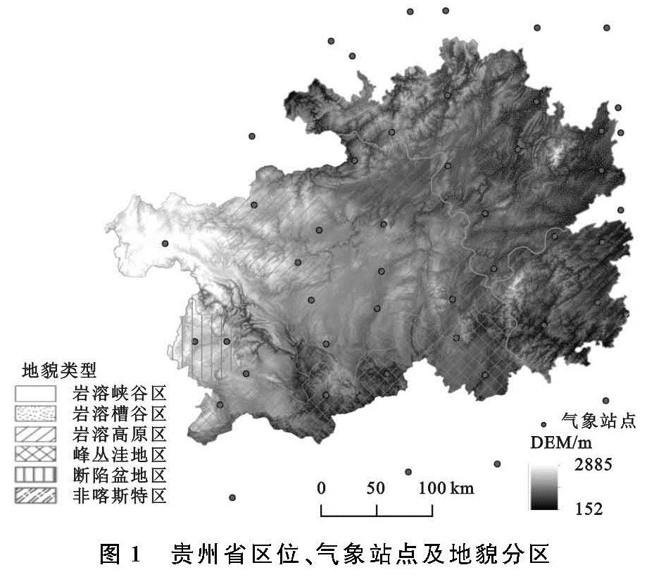
3.1 NDVI的变化特征
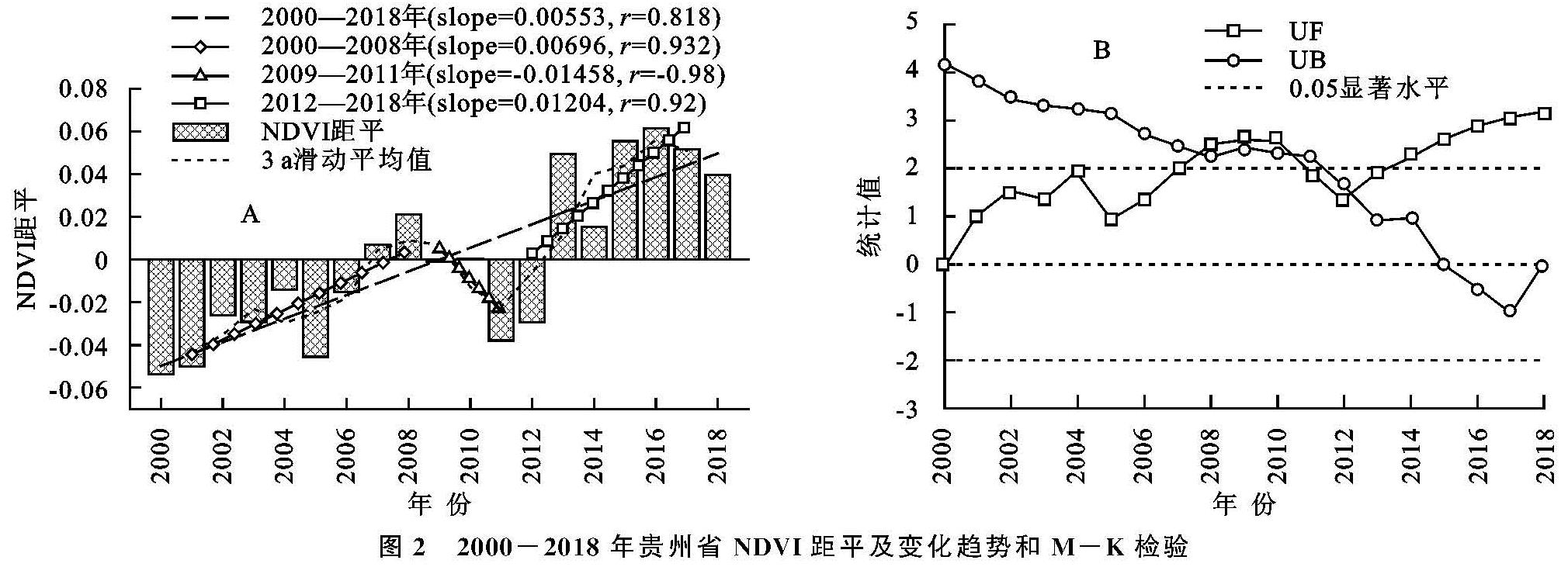
3.1.1 NDVI时空变化 从时间上看(图2A),贵州省年际NDVI距平介于-0.06~0.08,最高距平为0.061(2016年)高于多年年均NDVI值,其偏离程度大于最低距平为-0.054(2000年),整体呈现上升趋势,增速为5.53%/10 a。2008年以前NDVI平稳上升,增速为6.96%/10 a; 2009—2011年逐年下降,下降速率为-14.58%/10 a; 2012—2018年快速上升,增速为12.04%/10 a。
利用M-K检验探究2000—2018年研究区NDVI的突变情况(图2B),根据UF曲线可知,19 a间NDVI以增加作为变化趋势,UF与UB在2007年、2010年和2012年相交,其中2007年与2010年通过0.05的显著性检验,结合图2A可以发现这两个时间段NDVI距平出现了正负交替,表明2007年和2010年是NDVI的突变年份; 2012年虽未通过显著性检验,但于2013年超过显著水平,结合距平图可发现该时间点后植被NDVI进入快速增长时期。
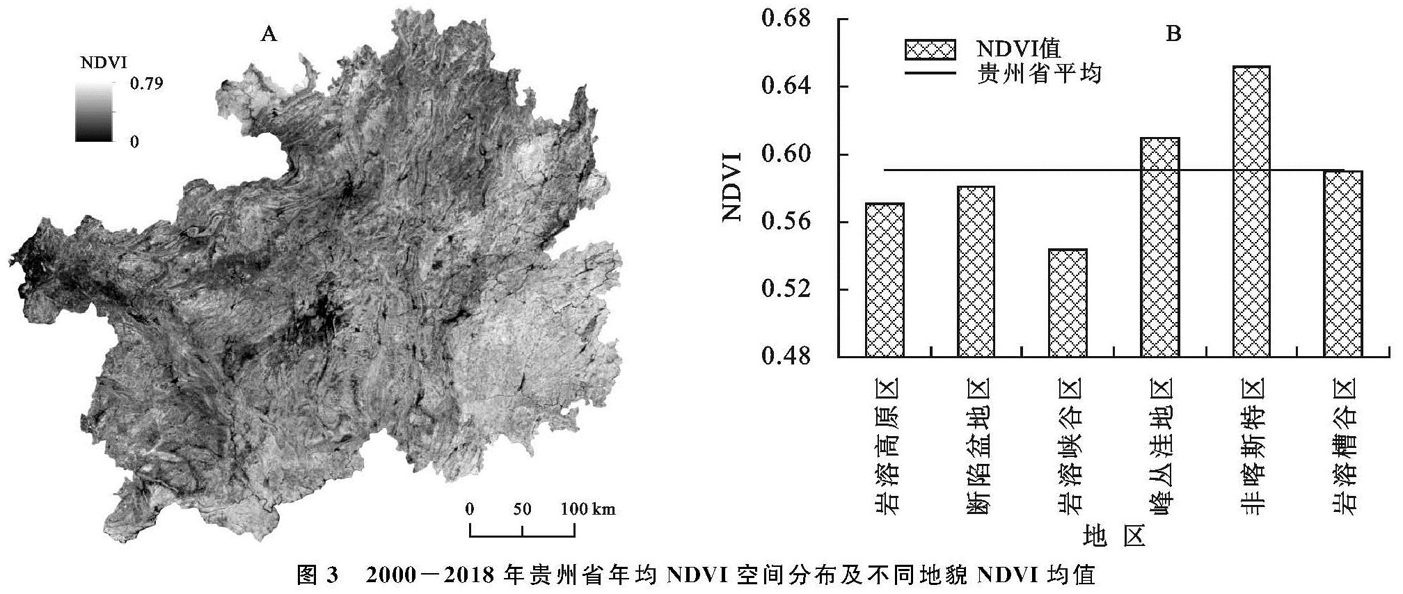
由图3A可以看出,贵州省多年年均NDVI介于0~0.79,NDVI高值区集中分布在贵州省东南地区,低值区主要分布在西部地区和各县市城镇聚集地,其空间分布呈现出西北低东南高的特点。从图3B可得,不同地貌类型下的NDVI均值存在差异性:非喀斯特地区>峰丛洼地区>省平均NDVI>岩溶槽谷区>断陷盆地区>岩溶高原区>岩溶峡谷区; 非喀斯特地区的年均NDVI(0.65)最大,比省平均值(0.59)高0.06,此地区成土周期短、土层较厚、土壤肥力高、水分含量高等特点,有利于植被的生长; 岩溶峡谷区的年均NDVI值最小(0.54),与省平均值相差0.05,与最大值相差0.11,导致该地区NDVI值偏小主要由于贵州省西部地区水土流失严重和石漠化程度高,植被生境严酷。
图2 2000-2018年贵州省NDVI距平及变化趋势和M-K检验
图3 2000-2018年贵州省年均NDVI空间分布及不同地貌NDVI均值
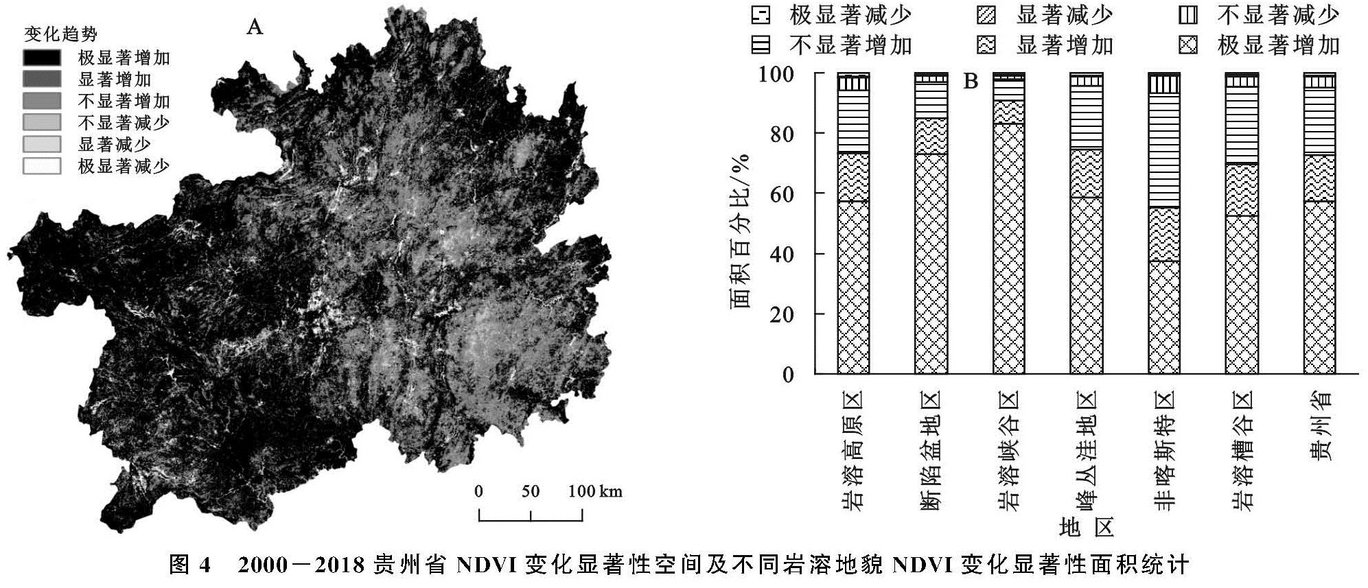
3.1.2 NDVI的空间变化趋势 图4A为贵州省年均NDVI变化趋势,大部分地区呈现不同程度的增加趋势,其面积占总面积的95.15%,其中呈极显著增加的区域面积比为57.32%,集中在研究区中部和西部地区; 呈减少趋势的面积仅占研究区面积的4.85%,其中极显著减少趋势区域的面积比为0.82%,主要分布在各县市城市区域; NDVI的变化趋势在空间上呈现西强东弱的格局。
由图4B可知,植被指数增长最显著的是岩溶峡谷区,该区域NDVI呈现增长趋势的面积占岩溶峡谷区面积的97.90%,其中极显著增加的面积占83.12%,显著增加的面积比为7.78%; 呈现减少的面积占比仅为2.10%。其次是断陷盆地区极显著增加和显著增加分别占该地貌类型面积的73.06%,11.93%。在岩溶高原区、峰丛洼地区和岩溶槽谷区相似,极显著增加和显著增加分别占其地貌类型面积的57.22%和16.00%,58.58%和15.96%,52.49%和17.22%,接近贵州省平均水平(57.32%和15.40%)。说明贵州省植被在19 a内增长十分显著,各岩溶类型下的植被增长存在着差异性,岩溶峡谷区增长程度最大,非喀斯特地区最小。
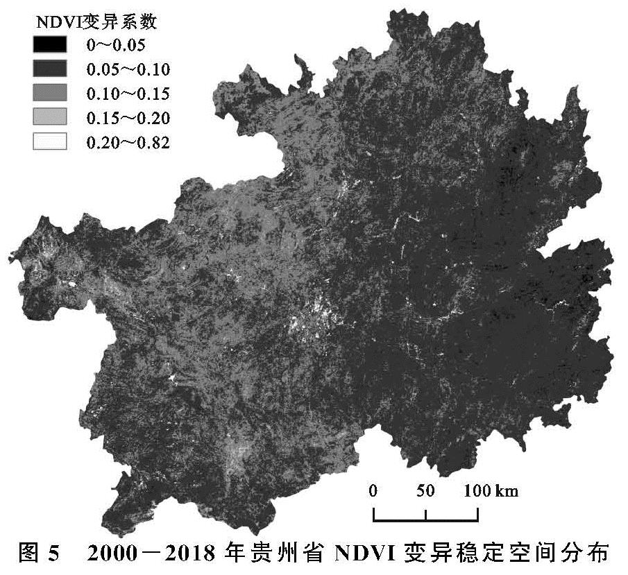
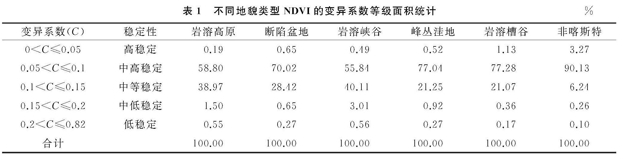
3.1.3 NDVI的稳定性分析 通过计算,获取贵州省2000—2018年NDVI的变异系数,根据变异值将波动程度划分为5个等级(图5)。由图5可知,贵州省变异系数介于0~0.82。波动性为低稳定和中低稳定的地区分布零散且面积小,主要分布在城市及其周边; 中等稳定的区域主要分布在贵州省的西北和北部地区,其面积占研究区总面积的27.55%; 中高稳定的区域分布广泛且面积大,其面积占总面积的70.06%; 低波动的面积小,其面积比为0.92%,比较集中分布在研究区的东部地区。贵州省NDVI以中高稳定和中等稳定为主,变异系数在空间上存在着西北高于东南的格局。
进一步分析不同地貌类型NDVI的稳定性,统计得到各等级稳定性的面积比例(表1),不同地貌类型的波动性均中高稳定和中等稳定状态面积占比相对较大,但比例存在差异性,喀斯特地貌的中高稳定状态区域的面积占该地貌面积是最大的,为90.13%,中等稳定的面积比为6.24%,低稳定面积比仅为0.1%; 岩溶峡谷地貌的中高稳定区域面积比例为最小,为55.84%,中等稳定的面积比40.11%,低稳定面积比为0.56%。
图4 2000-2018贵州省NDVI变化显著性空间及不同岩溶地貌NDVI变化显著性面积统计
图5 2000-2018年贵州省NDVI变异稳定空间分布
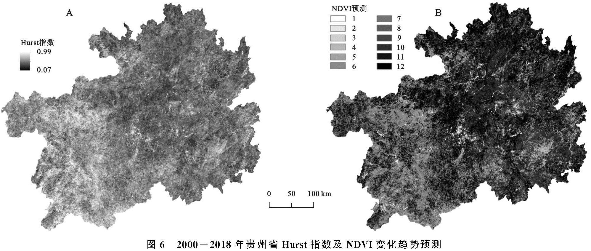
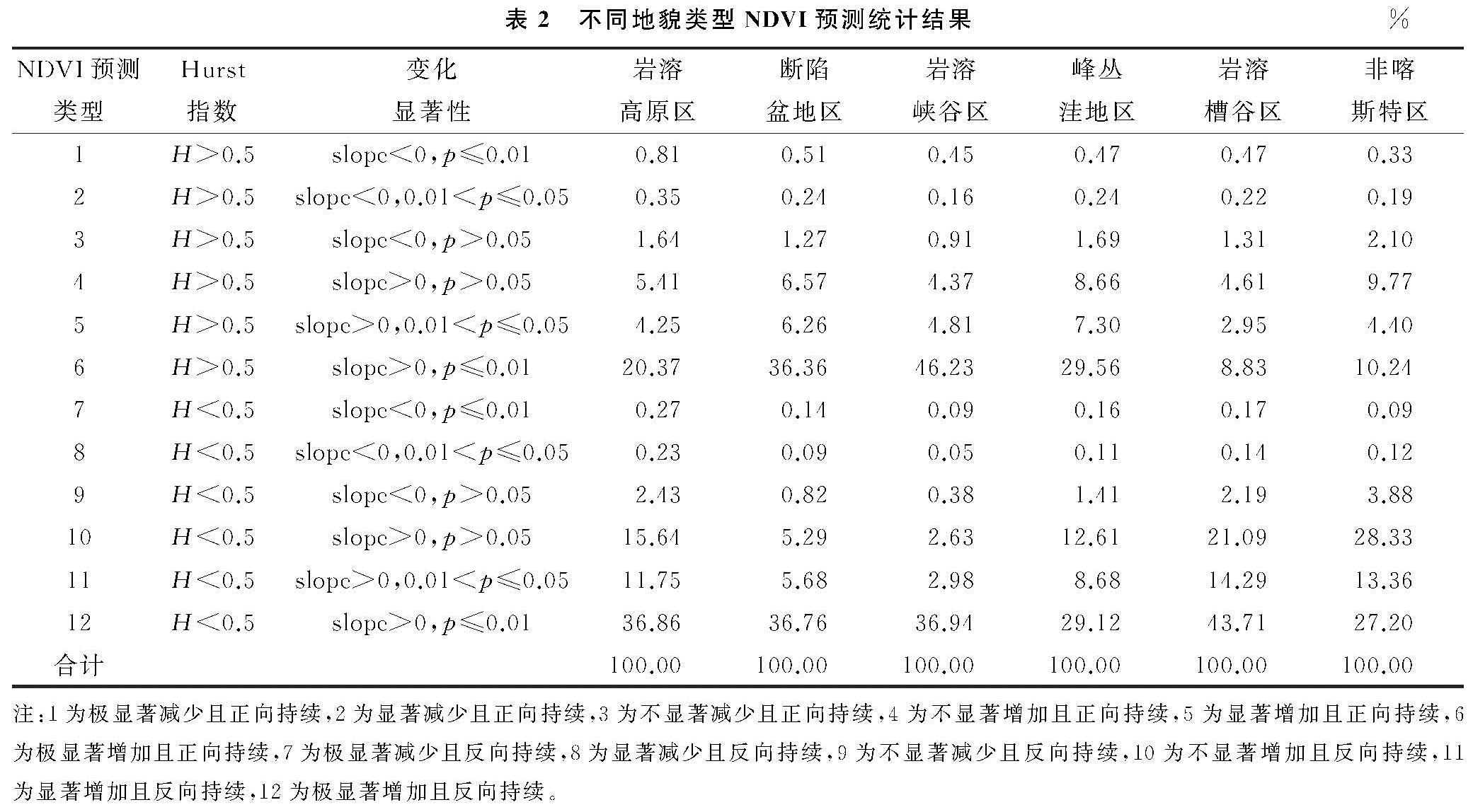
3.1.4 NDVI的可持续性分析 为了分析贵州省NDVI变化趋势的可持续性,逐像元计算NDVI 19 a的Hurst指数(图6A); 贵州省NDVI的Hurst指数介于0.07~0.99,均值为0.48,Hurst指数小于0.5的区域面积占比为66.28%,大于0.5的区域为33.72%,说明贵州省大部分地区植被的反向持续性强,即未来的变化趋势与过去相反。Hurst指数高值主要分布在贵州省西部地区,低值主要分布在贵州东部地区。从不同地貌类型来看,Hurst指数平均值最高的是岩溶峡谷区,为0.52; 其次是断陷盆地区(0.51); Hurst指数平均值最低的是岩溶槽谷区,为0.43。将贵州省NDVI变化显著性与Hurst指数叠加得到NDVI变化趋势预测图(图6B)。减少且正向持续的区域分布较为零散且面积较少,主要分布在贵州省的县城或市区及其周边区域,说明该区域受人类活动影响较为明显。增加且正向持续的区域主要分布在研究区西部,其中极显著增加且正向持续区域的面积占研究区面积的20.87%,是NDVI预测为正向持续类型面积占比最大的类型。极显著增加且反向持续的面积占总面积的36.5%,其广泛分布于研究区内; 其次是不显著增加且反向持续,其面积比为16.38%,集中分布于研究区北部、东部和南部地区。显著减少且反向持续的面积占比最低,为0.15%。
表1 不同地貌类型NDVI的变异系数等级面积统计%
贵州省不同地貌类型NDVI预测类型的面积结果见表2,岩溶峡谷区和断陷盆地区Hurst指数大于0.5区域的面积占该地貌面积的56.94%,51.21%,小于0.5区域面积比为43.06%,48.79%,说明该地区大部分区域呈现正向持续。其余地貌区以反向持续的区域面积比相对较大; 尤其是岩溶槽谷区反向持续面积比高达81.60%,说明该地貌的大部分区域未来变化趋势与过去相反。
图6 2000-2018年贵州省Hurst指数及NDVI变化趋势预测
3.2 温度、降水变化特征
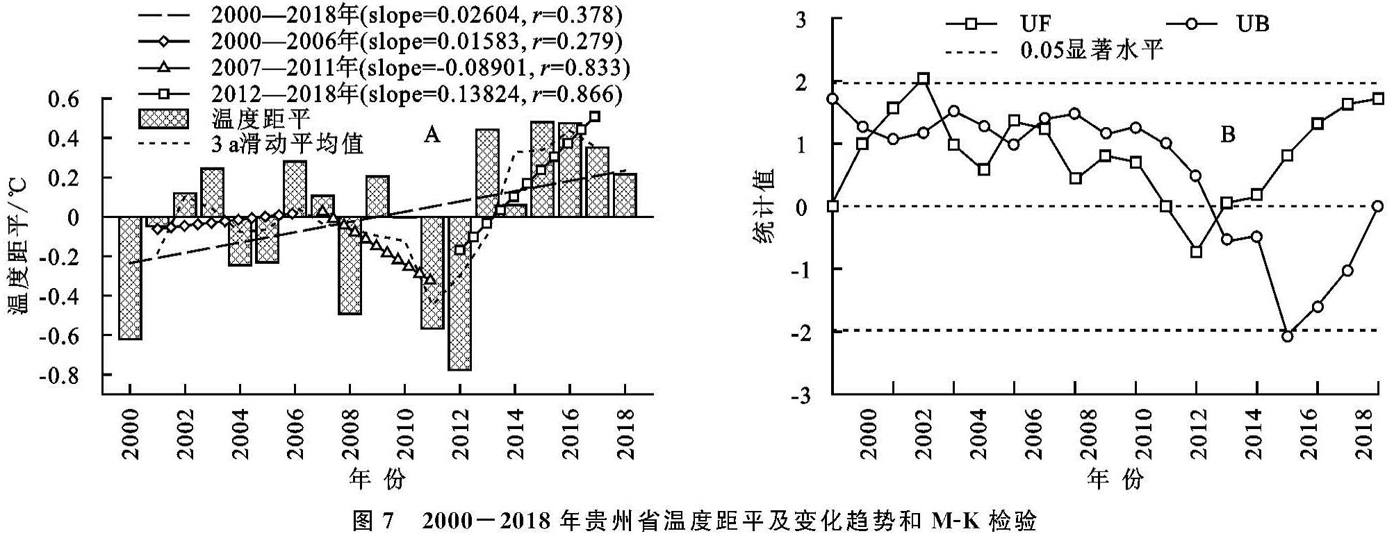
3.2.1 温度变化特征(1)温度的时空分布。从距平上看(图7A)2011年以前温度的波动比较大:2000—2006年为波动上升阶段,上升速率为0.158℃/10 a; 2007—2011年下降阶段,下降速率为-0.890℃/10 a; 2011年以后温度以1.238℃/10 a的速率上升; 贵州省19 a的温度以0.260℃/10 a上升; 上升的显著性不大。
观察2000—2018年年均温的M-K变化曲线(图7B),曲线UF在2003年通过0.05显著性检验,但仅表示年均温的随机性和不持续性; UF与UB在研究期间多次相交,但均未超过0.05的显著性检验,说明研究区19 a温度变化比较稳定。
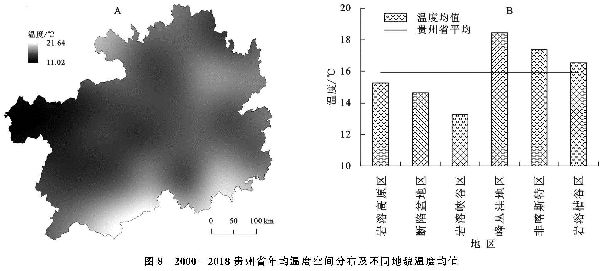
由图8A可知,贵州省温度介于11.02~21.64℃,最低温度主要分布在贵州省海拔较高的西部和中部地区,最高温度分布在南部地区,在温度空间上呈现西部地区低南部地区高的分布格局。峰丛洼地区、非喀斯特区和岩溶槽谷区年均温度分别高于贵州省年均温2.52,1.45,0.63℃; 岩溶高原区、断陷盆地区和岩溶峡谷区分别低于贵州省年平均-0.66,-1.27,-0.26℃; 最高温地区与最低温地区相差5.18℃(图8B),说明贵州省温度在空间上存在着异质性,不同地貌类型下也存在着差异性。
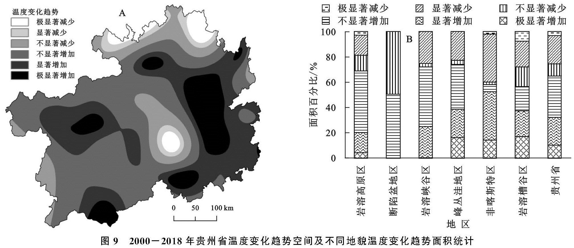
(2)温度的空间变化趋势。从图9A可以看出,贵州省存在5个温度极显著增长中心和2个极显著减少中心,变化趋势从极显著减少向极显著增加逐渐过渡。从图9B可以看出,贵州省年均温度变化趋势为增加区域的面积占研究区面积的65.02%,其中极显著增加的面积比为10.22%,显著增加的面积比为22.32%; 而减少趋势的面积比为36.78%,其中极显著减少的面积比为2.78%,显著减少的面积比为22.32%。
图7 2000-2018年贵州省温度距平及变化趋势和M-K检验
图8 2000-2018贵州省年均温度空间分布及不同地貌温度均值
图9 2000-2018年贵州省温度变化趋势空间及不同地貌温度变化趋势面积统计
由图9B可知,各岩溶地区温度变化趋势主要为增加,其中极显著增加趋势面积占比最大的是岩溶槽谷区,占该区域面积的17.25%,其次是峰丛洼地区,为16.49%,非喀斯特地区次之,为14.57%,面积占比最低的在断陷盆地区,为0.00%。以显著增加为趋势的区域在非喀斯特地区,其面积占该区域面积的38.31%; 其次是岩溶峡谷区(24.95%),峰丛洼地区次之(22.48%),面积占比最低的在断陷盆地区,为0.00%。贵州省温度呈减少趋势的区域面积占比为34.98%,其中呈极显著减少趋势的区域面积占研究区总面积的10.23%,显著减少的面积占比达22.32%; 各岩溶地区极显著减少面积占岩溶类型总面积比最大的在岩溶槽谷区(7.24%),其次是非喀斯特地区(1.44%); 以显著减少为趋势面积占比最大的地貌类型是非喀斯特地区(38.31%),面积占比最小的是断陷盆地区,为0.00%(图9B)。说明贵州省不同喀斯特地貌下温度变化趋势存在着差异性,断陷盆地区温度变化是最稳定的,非喀斯特地区和岩溶槽谷区的温度变化差异性较大。
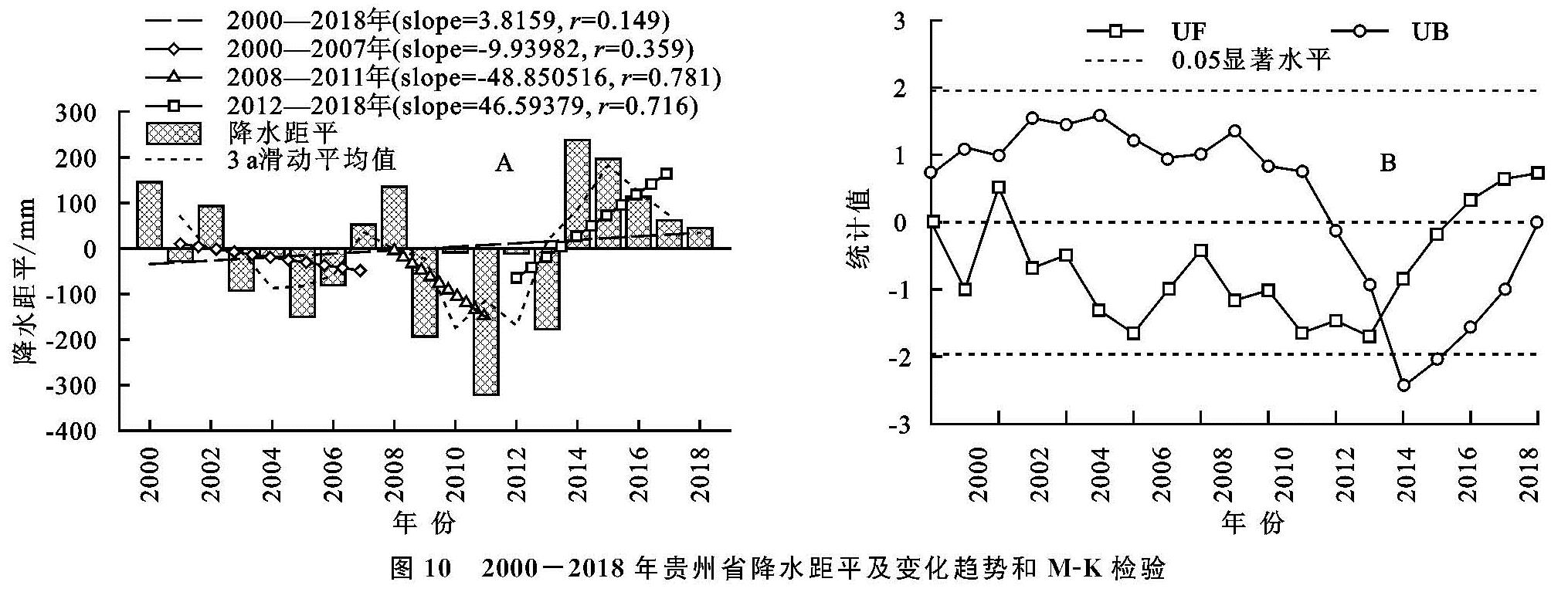
3.2.2 降水变化特征(1)降水的时空分布。由图 10A可知,贵州省年际降水量距平介于-321.00~238.02 mm,最高降水距平出现在2014年,偏离多年年均238.02 mm,最低降水距平出现在2011年,低于多年年均321.00 mm,与最高降水距平相差559.02 mm,说明贵州省年际降水量存在着差异性。降水整体呈现上升趋势,增速为38.16 mm/10 a,存在3个变化阶段:2000—2007年波动下降,下降速率为-99.4 mm/10 a,2008—2011年快速下降阶段,下降速率为-488.51 mm/10 a,2012—2018年上升阶段,上升速率为465.94 mm/10 a。
利用M-K检验探究2000—2018年研究区年均降水的突变情况(图 10B),根据UF曲线可知,19 a间降水量以增加作为变化趋势,UF与UB在2013—2014年出现相交,但未通过0.05的显著性检验,说明贵州省20 a来降水没有明显突变。
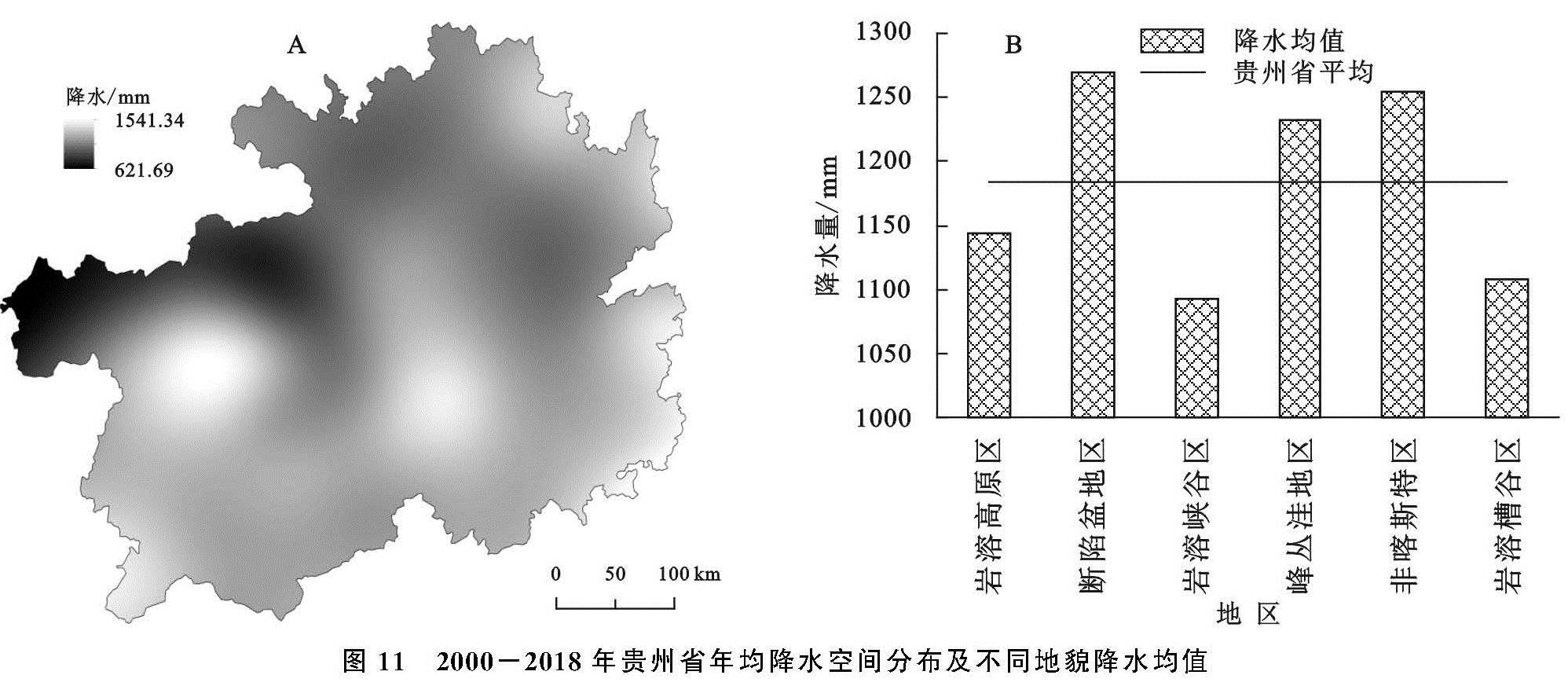
由图 11A可知,贵州省降水量介于621.69~1 541.34 mm,较低降水量主要分布在贵州省西北部地区,并逐步向南部和东部逐渐增加,在贵州省形成了2个多雨中心。结合图 11B得出,断陷盆地区(1 269.73 mm)、非喀斯特区(1 254.58 mm)、峰丛洼地区(1 231.95 mm)的降水量分别高于贵州省年均降水量(1 183.38 mm)86.36,71.20,48.57 mm; 岩溶峡谷区(1 092.76 mm)、岩溶槽谷区(1 107.31 mm)和岩溶高原区(1 143.93 mm)的降水量分别低于贵州省年均降水量(1 183.38 mm)90.61,76.07,39.45 mm。
图 10 2000-2018年贵州省降水距平及变化趋势和M-K检验
图 11 2000-2018年贵州省年均降水空间分布及不同地貌降水均值
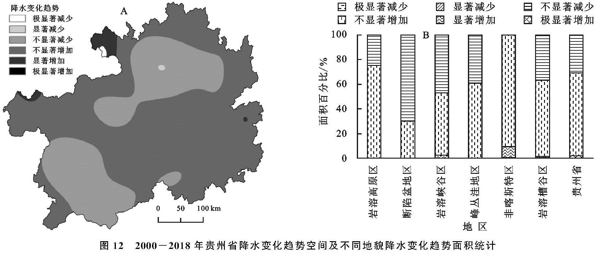
(2)降水空间变化趋势。从图 12A可以看出,贵州省的降水变化趋势大部分地区以增加趋势为主,其面积占研究区面积的69.19%(图 12B),其中极显著增加和显著增加的区域面积占比分别为0.14%,1.80%,主要集中在贵州省北部地区; 以减少为趋势的地区面积占研究区面积的30.81%,其中不显著减少为趋势的面积占比最大,为30.72%,主要集中在贵州省的东北部和西南部。各地貌区除了断陷盆地区减少趋势占优势,其他地貌区均以增加为趋势,其中非喀斯特区的显著增加是最大的,为8.96%,其次是岩溶峡谷区,其面积占比为2.65%; 岩溶槽谷次之,为1.31%,其余地貌均以不显著增加占优势,值得注意的是,断陷盆地区不显著减少为趋势的面积占该地貌类型面积的69.95%。说明各地貌类型下的降水变化趋势存在着差异性,除断陷盆地区减少占优势,其他地貌区均呈现不同程度的增加。
图 12 2000-2018年贵州省降水变化趋势空间及不同地貌降水变化趋势面积统计
3.3 NDVI对温度、降水变化的响应
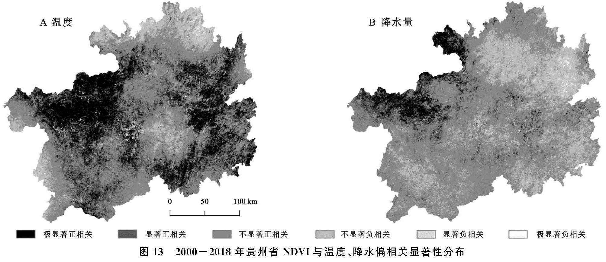
贵州省年际NDVI与温度呈现显著正相关(r=0.66,p<0.01),与降水的相关性较弱且不显著(r=0.36,p>0.5)。为了进一步确定温度和降水是如何影响NDVI的变化,对贵州省2000—2018年年均温、年降水量与NDVI进行偏相关性分析并结合其显著水平得到相关性空间分布图(图 13)。如图 13A所示,在空间上,贵州省NDVI与温度以正偏相关为主,正偏相关面积占研究区面积的88.88%; 其中极显著正相关主要分布在贵州省西北部和东部,其面积比为24.71%,接近研究区面积的1/4。NDVI与温度呈现负偏相关的地区主要集中在研究区北部、西部和中部地区,其面积比为11.12%,极显著负相关和显著负相关面积仅占研究区面积的0.13%,0.61%。
由NDVI与降水的偏相关显著性空间分布可知(图 13B),NDVI与降水正、负偏相关分别占全省面积的75.24%,24.76%; 极显著正相关主要分布在贵州省西北部地区,面积占比为6.19%; 极显著负相关主要分布在研究区东偏北的少部分地区,其面积比为0.22%; 面积占比最大的是不显著正相关,为60.76%,其次是不显著负相关的面积比(23.73%)。
NDVI与年均温的偏相关性高于其与降水的偏相关性贵州省植被生长受温度的影响高于降水。二者在空间分布上存在异质性,且研究区西北部地区受到温度和降水的共同影响。
由表3可知,不同地貌区的NDVI受年均温和降水存在差异性,断陷盆地区受温度和降水的影响均不显著; 岩溶高原区、岩溶峡谷区和非喀斯特地区受温度的影响高于降水,该地貌区的NDVI与温度偏相关系数通过0.05检验的正相关面积比分别为54.87%,57.41%和56.98%,均超过其地貌区面积的1/2; 而通过0.05检验的负相关面积比均未超过4%,说明NDVI受温度的正向影响大,显著性强。不同地貌类型下,呈现极显著正相关(p<0.01)的面积比(S)大小排序为:断陷盆地(1.69)<岩溶槽谷区(16.69)<峰丛洼地区(18.33)<岩溶峡谷区(27.27)<非喀斯特地区(29.86)<岩溶高原区(33.34)。
降水对NDVI的影响在不同地貌区之间的差异较大,NDVI与降水偏相关系数通过0.05检验的正相关面积比最大的是岩溶峡谷区,为30.69%; 断陷盆地区仅为2.43%,二者相差28.26%。呈现极显著正相关(p<0.01)的面积比存在差异性:断陷盆地(0.2)<峰丛洼地区(0.41)<岩溶槽谷区(2.63)<非喀斯特地区(7.10)<岩溶高原区(8.92)<岩溶峡谷区(13.71)。
图 13 2000-2018年贵州省NDVI与温度、降水偏相关显著性分布
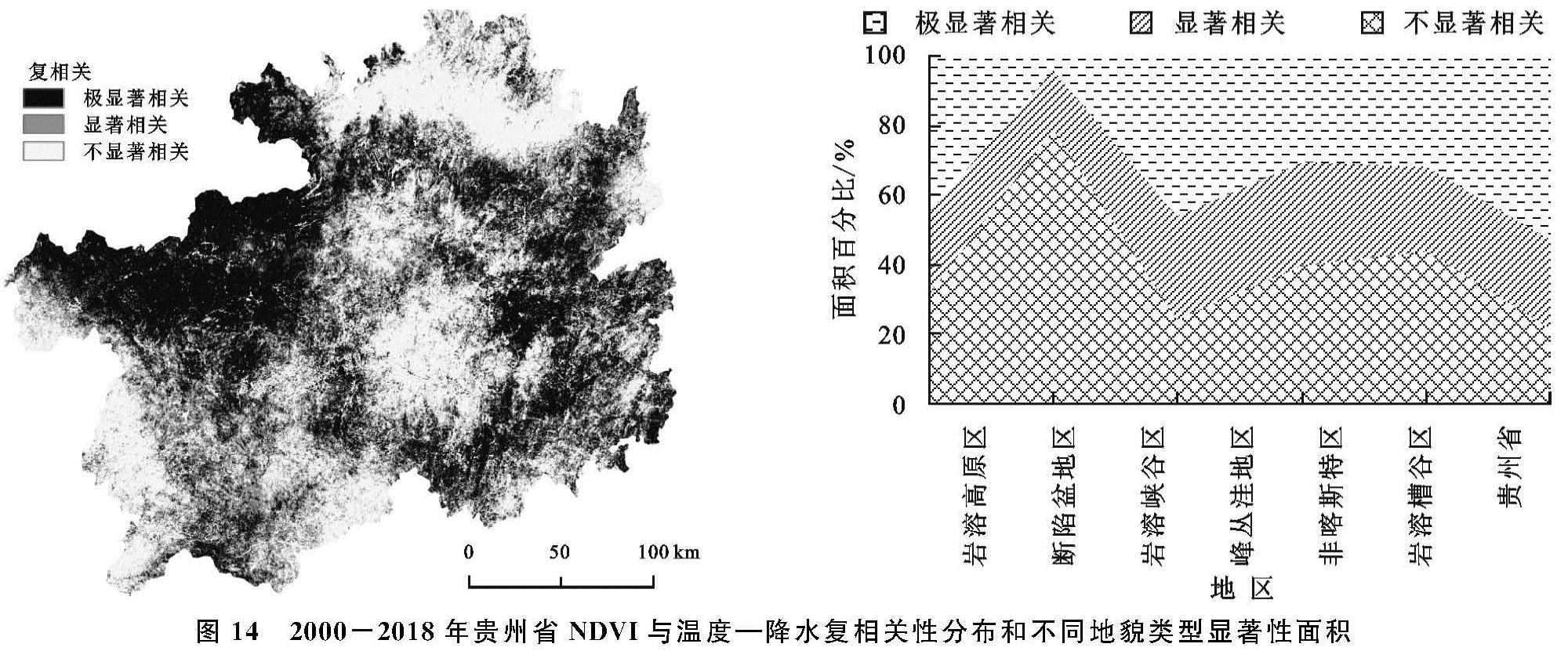
由图 14A可知,NDVI与温度、降水的复相关性显著和极显著相关的区域分布面积广,分别占研究区面积的39.36%和25.30%,35.34%的区域未通过0.05的显著性检验(图 14B)。断陷盆地区通过0.05显著性检验的面积占该地貌总面积的21.10%,其他地貌通过0.05显著性检验的面积比均超过对应地貌的55%以上,其中非喀斯特区面积比为78.12%,可见非喀斯特地区受气候变化的影响较为显著,断陷盆地区最不显著。
图 14 2000-2018年贵州省NDVI与温度—降水复相关性分布和不同地貌类型显著性面积