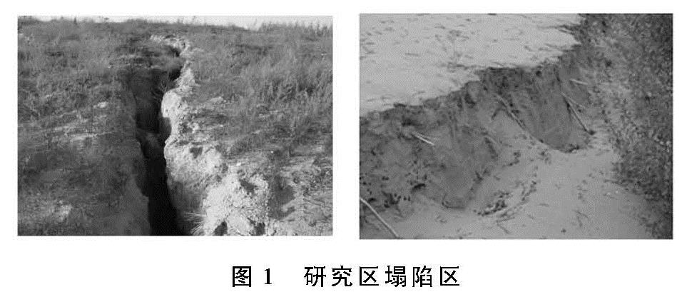
3.1 采煤塌陷对微地貌影响
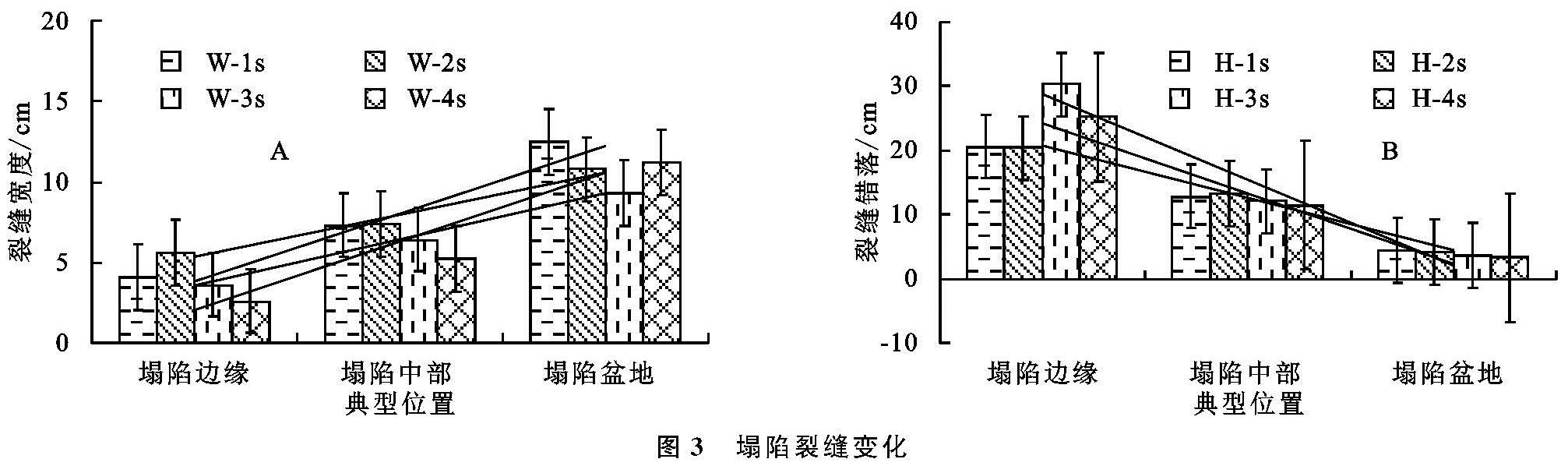
采煤塌陷后形成的塌陷边缘、塌陷中部及塌陷盆地,裂缝纵横交错,沙质地表变得支离破碎,形成了大小不一、层次错落的裂缝(图3)。据分析,塌陷裂缝宽度及错落与塌陷位置具有很大的差异性,从4条随机抽样的塌陷裂缝统计数据表明:塌陷边缘裂缝宽度变化为(2.6±0.3)~(4.1±0.2)cm,平均宽度为(3.9±0.25)cm; 塌陷中部为(5.2±0.2)~(7.3±0.1)cm,平均为(6.6±0.15)cm; 而塌陷盆地则变化为(9.3±0.1)~(12.5±0.2)cm,平均为(10.9±0.15)cm,裂缝的平均宽度增加了2.75倍(图3A)。总体表现出塌陷边缘宽度最小,塌陷中部次之,塌陷盆地最大,而错落高度的变化则反之,从塌陷盆地到塌陷边缘,其裂缝平均错落增大了6.23倍(图3B)。采煤塌陷形成的塌陷裂缝变化使原本得到固定、半固定沙丘可能引发“二次”风蚀或风积情况,甚至进一步干扰植被的生长环境。
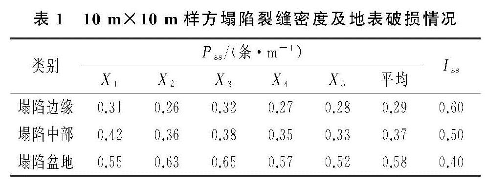
同理,采煤塌陷位置不同,其形成的裂缝密度和地表破损率也有所不同(表1),从塌陷边缘到塌陷盆地裂缝密度依次增大,分别为0.29,0.37,0.58条/m,而单位面积地表破损率则不断地减小,为0.60,0.50,0.40。这是由于采煤塌陷时重力势能转化为动能,塌陷边缘更容易造成局部的滑坡或崩塌,结合分析结果可知,塌陷边缘裂缝宽度虽小,但错落高度相对较大,土壤内部结构发生严重变化,因而使地表遭到的破坏最为强烈,这种现象往往会导致植被发生位移、剪切,甚至拉伤根系,对植被的生长损坏最为严重; 而塌陷中部和塌陷盆地则反之,造成裂缝宽度逐渐增大,裂缝密度增多,但错落高度和地表破损程度反而进一步减小,对植被造成的影响也相应减小。
表1 10 m×10 m样方塌陷裂缝密度及地表破损情况
3.2 采煤塌陷对植被的影响
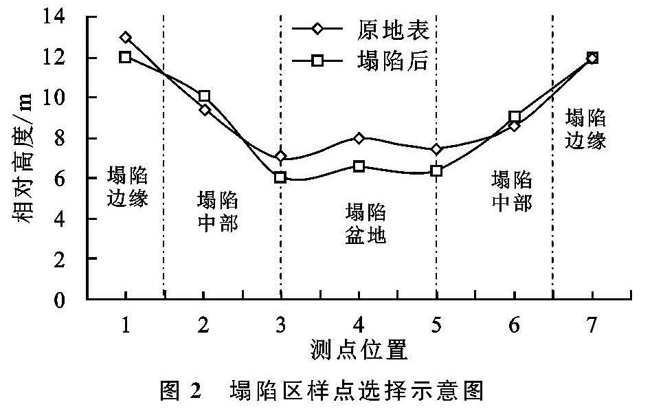
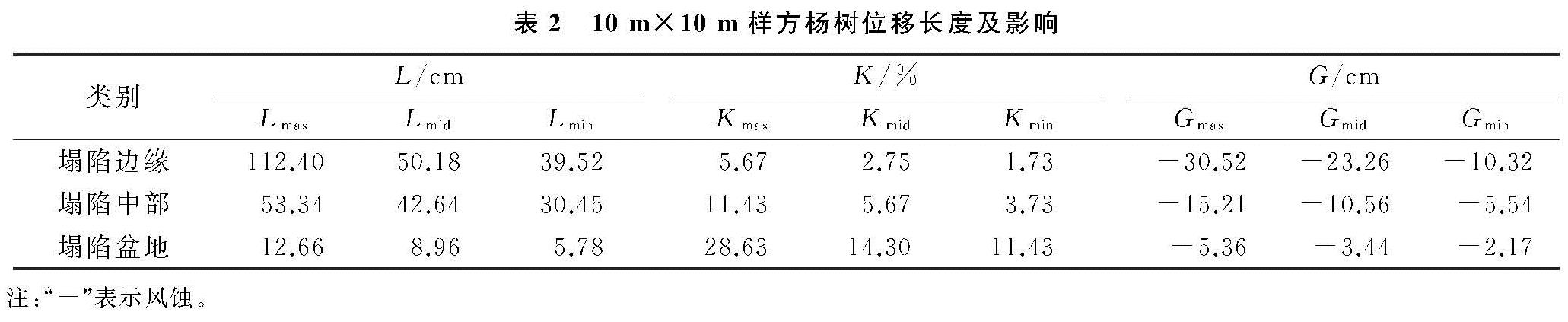
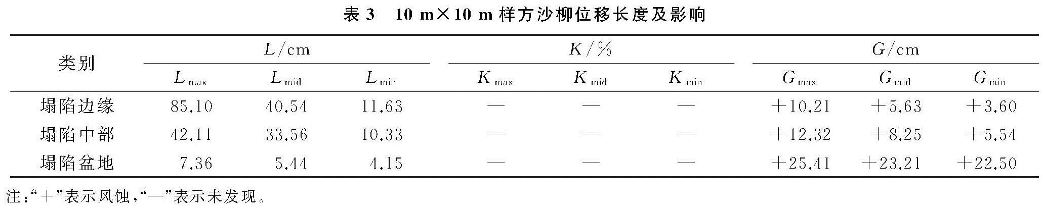
由以上分析可知,当采煤发生塌陷时,地表会形成塌陷裂缝和错落,导致区域乔灌木发生不同的位移、倾斜。表2—3样方调查中,为随机选择塌陷区两个主要建群种杨树和沙柳在不同的塌陷位置发生的位移长度、倾斜程度及1 a后主干根部出露地表的风蚀/风积厚度统计变化。
由表2—3可以看出,不同塌陷位置的杨树和沙柳位移长度和斜率均有所不同,塌陷边缘杨树最大位移长度甚至达到110 cm以上,沙柳为85 cm左右,塌陷中部为53.34,42.11 cm,而塌陷盆地最大位移仅为12.66,7.36 cm。同理,杨树的倾斜率以塌陷边缘为最大,达到1.73~5.67,塌陷中部3.73~11.43,而塌陷盆地基本未发生倾斜(表2)。据分析,植被的位移长度与塌陷裂缝错落高度呈线性正相关关系,错落高度越大,植被的位移长度也越大,其倾斜的程度也越高。
地表塌陷后沙质地表变得更加疏松,且伴随着乔灌木的位移和倾斜,在风的作用,引发一定程度的风蚀/风积现象,从而导致根系外露或者堆积,对植被的生长造成一定的影响(表2—3)。由于乔灌木树种的防沙的特性不同,杨树更容易在主干根部发生风蚀现象,最大风蚀发生在塌陷边缘,达到-30.52 cm左右,而塌陷盆地最小,约为-5.36 cm(表2)。据现场调查,在塌陷边缘位置,大多数杨树主根周围2 m范围内,根系裸露非常严重,对杨树的生长影响很大,而塌陷中部和塌陷盆地影响相对较小,只有部分根系外露,对植被的生长影响相对较小; 沙柳由于根部多枝丛生,容易阻拦风沙,在3个不同的塌陷位置均出现风积现象,以塌陷盆地最大,塌陷中部次之,塌陷边缘最小,最大风积厚度分别为+25.41,+12.32,+10.21 cm(表3),对沙柳的生长反而起到一定的促进作用。
3.3 采煤塌陷对干沙层及风蚀/风积的影响
采煤塌陷后,地表变得支离破碎,引起沙质地表干沙层厚度发生变化,对塌陷区不同位置18个样点随机抽样干沙层等值线变化见图4。非塌陷时,沙质地表基本为一个封闭的整体,干沙层的厚度变化与土壤蒸发有直接的关系,通常的影响因素有土壤结构、土壤表面特征及地形因子[1-2]。据分析,3个随机的抽样点18个剖面的干沙层变化稳定在6—10 cm(图4B),遵循丘顶干沙层较厚,丘间干沙层相对较薄的规律,这符合毛乌素沙地一般沙丘干沙层变化规律[1-2]。
采煤塌陷后,塌陷导致沙质土壤变得更加疏松,结构发生变化,表面形成塌陷裂缝和错落,促使塌陷区不同位置干沙层厚度普遍增加,且在图中等值线表现出非常紊乱,高低不一,已不符合沙区干沙层变化规律。3个随机的抽样点18个剖面的平均厚度达11.10 cm,比非塌陷增大了37.50%。这种变化尤其表现在塌陷边缘最为明显,其干沙层厚度甚至达到在14 cm以上(图4B),比对照增大了4~6 cm; 而塌陷中部和塌陷盆地的干沙层厚度相对较小,变化在11 cm左右,比非塌陷增加了1~4 cm。
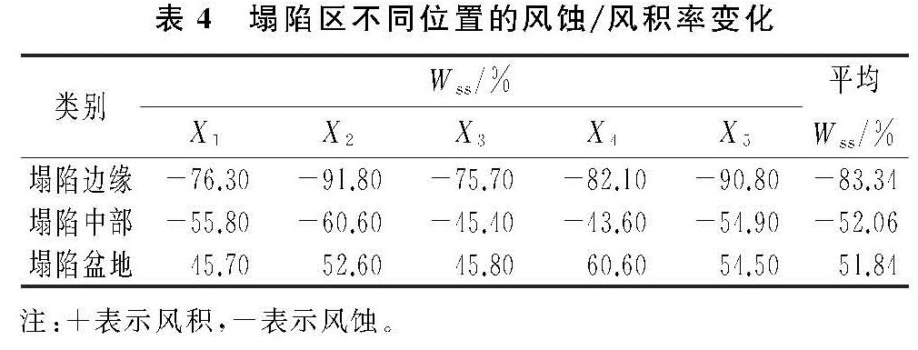
干沙层的这种变化,将会直接导致塌陷区不同位置的风蚀/风积面积发生变化(表4)。采煤塌陷后形成的塌陷边缘、塌陷中部及塌陷盆地,在风的作用下都有不同程度的风蚀/风积现象出现,但是综合来看以塌陷边缘最为明显,主要以风蚀现象为主,平均风蚀率高达83.34%,塌陷中部次之,为52.06%,而塌陷盆地则由风蚀转为风积现象,风积率高达51.84%(表4)。这说明采煤塌陷产生的塌陷裂缝和错落,改变了局部的地形地貌,间接增加了与空气的接触面积,土壤蒸发量增大,导致沙质土壤进一步的旱化,风蚀/风积面积逐渐扩张,进而影响植被的生长。
3.4 “二次”荒漠化诊断与整治对策
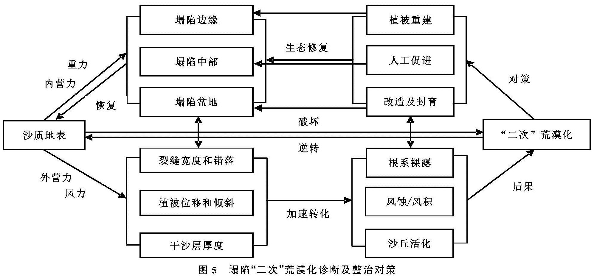
由以上分析可知,采煤塌陷后会引起一系列的连锁反应,首先是在内营力塌陷重力影响下地表产生裂缝和错落,造成不同塌陷位置的裂缝纵横和地表破损,引发乔灌木位移和倾斜。在外营力风的作用下,植物体周围发生风蚀或风积,促使植被根系外露,逐渐丧失防风固沙的能力,进一步地塌陷,风蚀/风积面积扩大,直接影响植物的生长,从而导致固定半固定沙丘重新活化,最终形成塌陷区“二次”荒漠化(图5)。
因此,采煤塌陷后应该及时地进行分区生态修复,避免引起整个塌陷区的“二次”荒漠化,建议在塌陷边缘经过裂缝土地整治和工程(沙障)措施后,进行植被的恢复与重建; 塌陷中部做适当改造(平茬形成活沙障)后,进行人工促进生态修复; 而对塌陷盆地则进行适当的改造后,封育自我生态修复。