1.3.1 TRIGRS模型设置
TRIGRS模型针对饱和或近饱和土壤初始条件下的入渗模块是基于Richard方程的线性解析解形式建立,可得到不同土层深度和时间下孔隙水压力的大小:
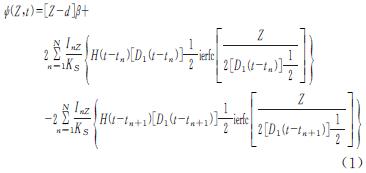
式中:ψ为孔隙水压力; t为时间; Z为土层深度; d为地下水位深度; δ为坡角; Ks为垂向饱和渗透系数; β=cos2δ-(IZLT/Ks); IZLT为初始表面通量; InZ为第n个时间段的表面通量的强度; D1=D0/cos2δ; D0为饱和水力扩散系数; N为时间段总数; H(t-tn)为Heaviside阶梯函数; ierfc(η)为高斯补误差函数。
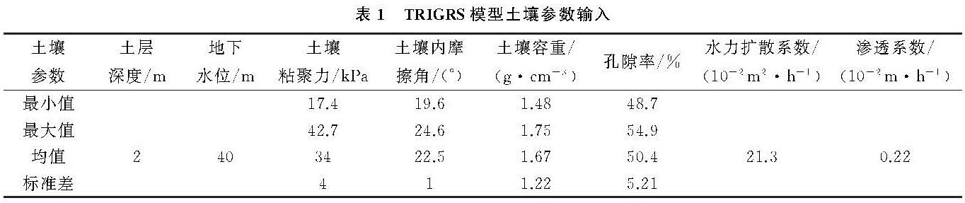
研究区内降雨诱发型滑坡的发生一般都有前期降雨存在,故采用土壤初始条件饱和的无限边坡模型选项。TRIGRS模拟地形控制参数选取25 m分辨率的数字高程模型(DEM),相关土壤参数参考庄建琦等[7]在延安宝塔区进行的实地试验,参数选取见表1。
1.3.2 边坡稳定性的计算
边坡稳定性计算采用适用于浅层滑坡的无限边坡稳定性分析,安全系数Fs(Factor of Safety)定义为土块下滑阻力与动力的比值,基于Mohr-Coulomb破坏准则和孔隙水压力的变化,不同土层在不同时刻的安全系数可以表示为:
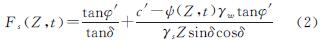
式中:c'为土的有效黏聚力; φ'为土的有效内摩擦角; γw为地下水的容重; γs为土的容重; Fs为安全系数。
斜坡稳定性分析中存在较大的不确定性,建立合理的可靠度模型是解决不确定性的重要方法[19-20]。本研究采用Rosenblueth在1975年提出的点估法来建立浅层滑坡分析的可靠度分析模型,其基本原理为:在随机变量分布未知时,可利用各种变量的均值和方差来计算出功能函数的一阶矩和二阶矩,从而得到斜坡的可靠度指标和破坏概率。斜坡稳定的功能函数可设为:
F=g(X1,X2,…,Xn)(3)
式中:X1~Xn为与斜坡稳定性相关的多种因素; F为稳定系数。设F服从正态分布,且各项因素之间相互独立,则相应的可靠度指标为:

式中:β为可靠度指标; EF和DF分别为稳定系数的均值和方差。
利用点估法,在随机变量分布函数未知的情况下,在区间(xmin,xmax)上对称地取2个点,如取均值的正负标准差,即:
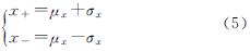
考虑斜坡稳定性影响最大的粘聚力(c)和内摩擦角(φ)两个因素,则可以得到4种不同的强度参数组合。通过不同强度参数的组合可以得到4种不同的稳定系数:

式中:σ为标准差。
根据式(4)和式(6),斜坡的失稳概率Pf为:
Pf=1-Φ(β)(7)
式中:Φ为标准正态分布函数。
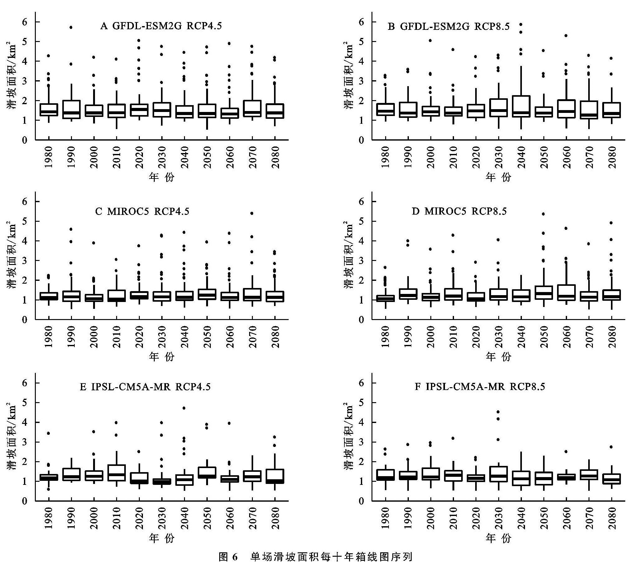
采用上述的Rosenblueth点估法,在3个不同的时间段(H,F1,F2)将提取的降雨事件作为TRIGRS模型的降雨驱动参数分别模拟每场降雨的滑坡发生分布情况,其中每场降雨事件根据选取的点估法的4种参数组合需重复进行四次模拟可得出每个网格的四组安全系数Fs,再根据式(7)计算出每个网格点滑坡发生的概率。
对1.2.2中选取的全部降雨事件进行模拟,其中在历史时期(H)共进行了3 888次模拟,两个未来时期(F1,F2)共进行了9 300次模拟。一般来说,0.5的失效概率相当于安全系数为1的情况[21],因此本研究后续分析中着重关注滑坡失稳概率大于0.5的情况。