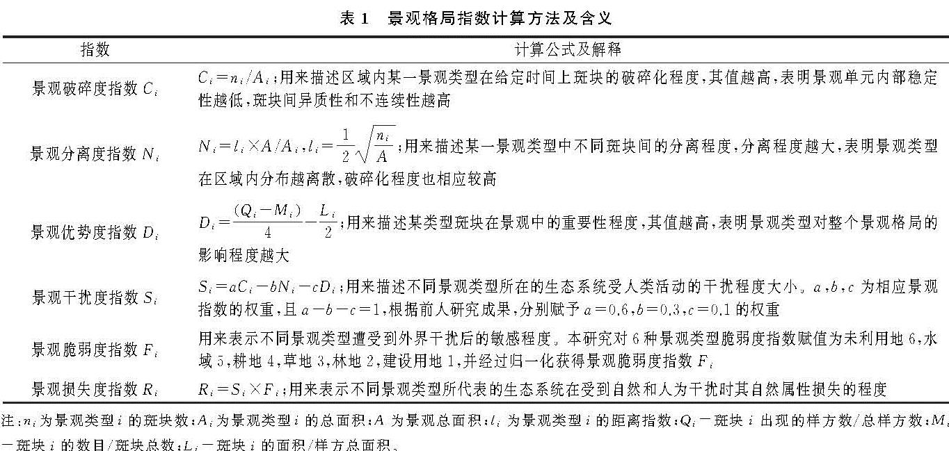
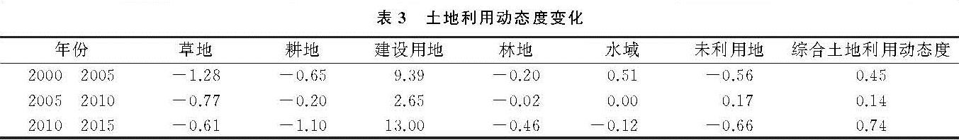
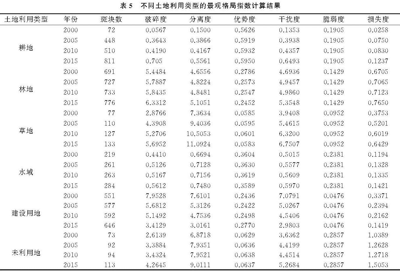
3.2.1 景观格局指数变化分析
基于Fragstats和Excel软件,根据表1中所列公式分别计算2000年、2005年、2010年、2015年各土地利用类型的景观格局指数,并进一步分析其变化规律(表5)。可以看出15 a来,各景观类型斑块数目均表现为不同程度的增加,直接影响景观破碎度指数、分离度指数。建设用地由于面积的增长速度明显快于斑块数目增长速度,导致其破碎度指数、分离度指数不断减小,表明建设用地各斑块趋向于集中连片式发展,集聚程度增强、内部稳定性增大。耕地作为区域的优势景观类型其优势度指数最大,其他地类优势度指数变化不显著。从各地类所受干扰程度来看,林地、草地、未利用地的干扰度指数较大且随时间递增,建设用地的干扰度指数随时间逐渐减小。从损失度指数来看,未利用地的损失程度最大,且表现为不断增大的趋势,主要原因是未利用地的破碎度和分离度指数不断增大导致干扰度相应变大,另外,未利用地的脆弱度指数最高也是其损失度大的原因,建设用地由于近年来的规模化集聚扩张、抗干扰能力的提高,景观损失度减小。
3.2.2 土地利用生态风险空间自相关特征
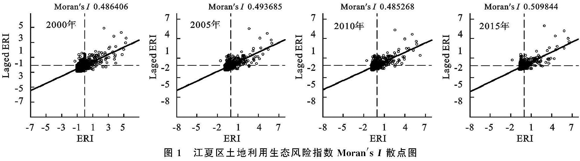
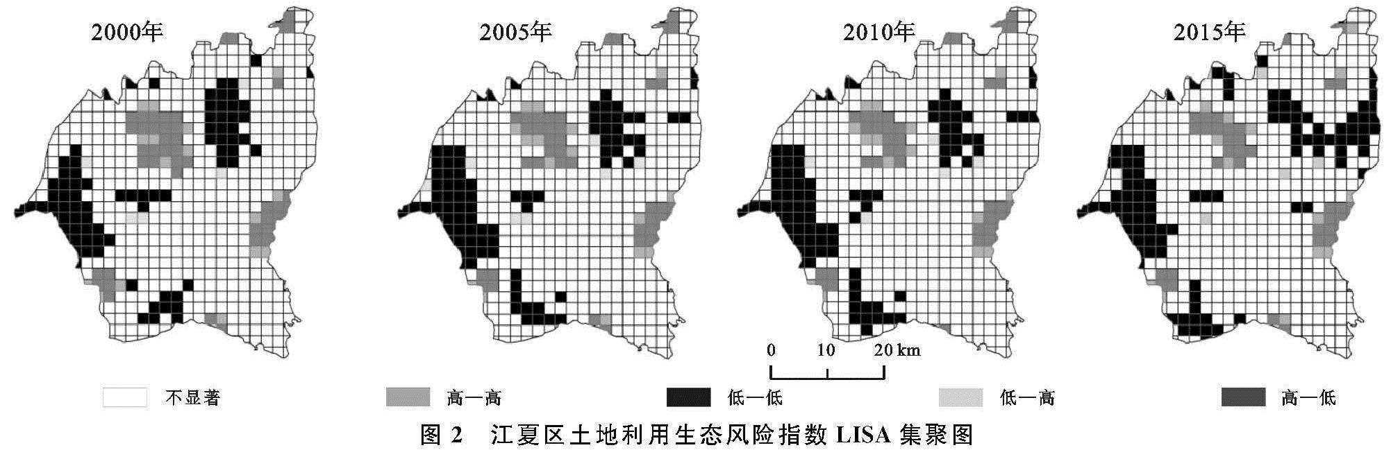
根据公式3计算得到各风险小区的土地利用生态风险值,导入GeoDa软件得到Moran's I散点图和LISA集聚图(图1,图2)。从全局空间自相关Moran's I值看,四期Moran's I值分别为0.486 4,0.493 7,0.485 3,0.509 8,值均为正数且呈上升趋势,表明土地利用生态风险有较强的空间正相关性,存在集聚效应。从局部空间自相关的LISA集聚图看,土地利用生态风险高值集聚区主要位于建成区中心附近林地、草地所在区域和东部梁子湖附近未利用地,建成区附近的林地、草地受外界干扰度大,尤其是建设用地的转入影响,破坏了原有景观的稳定性,使景观损失度增加; 低值集聚区分布较广,主要分布在西部、中东部,此区域以水域和耕地为主,受外界干扰程度小,低值集聚区在2010—2015年向东部牛山湖附近转移,集聚程度增强。总体来看,江夏区土地利用生态风险强度整体分异显著,局部空间差异也在扩大。
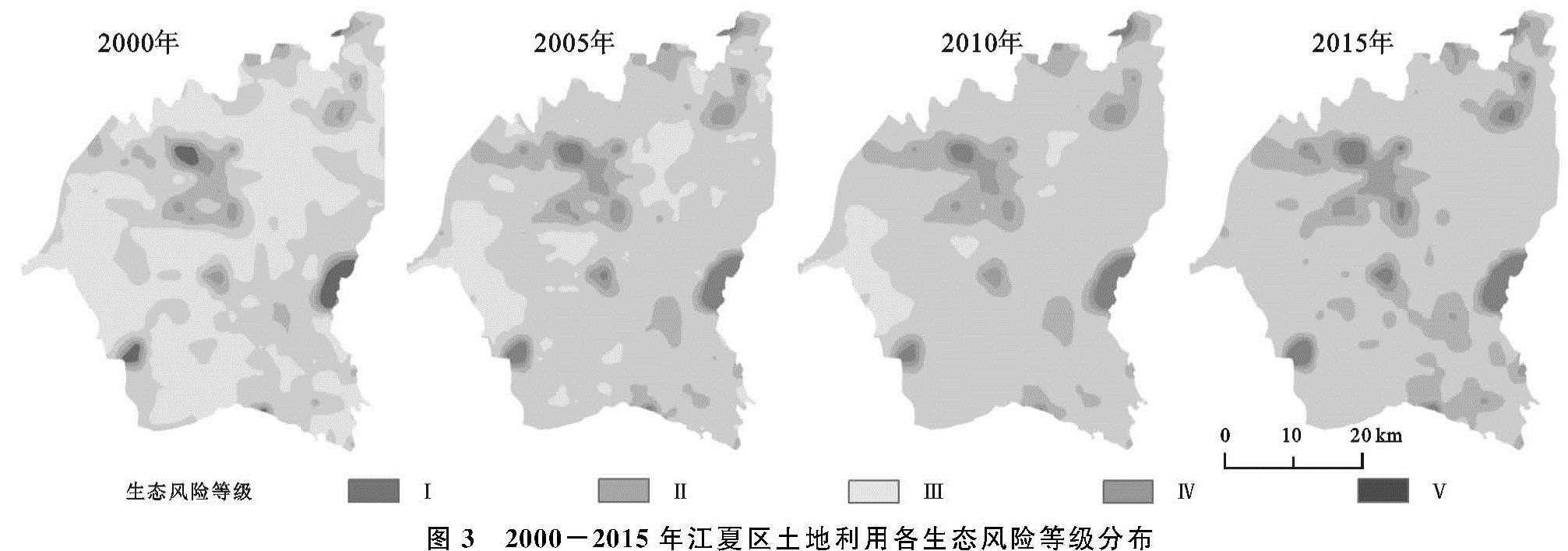
3.2.3 土地利用生态风险时空分布格局 将各风险小区中心点风险指数值进行克里金插值,得到江夏区土地利用生态风险等级时空分布图(图3)。四期生态风险均值分别为0.117 4,0.157 0,0.163 6,0.190 8,区域土地利用生态风险整体呈上升趋势。2000年,低生态风险区面积将近占研究区总面积的一半,2005年之后,较低生态风险区所占比重最大,低生态风险区面积占比从2000年的49.81%下降到2015年的0.01%,而其余4类等级生态风险区面积均较2000年不断上升。
图1 江夏区土地利用生态风险指数Moran's I散点图
图3 2000-2015年江夏区土地利用各生态风险等级分布
从空间分布上来看,低生态风险区和较低生态风险区分布广泛,高生态风险区呈团状集聚分布在江夏中心城区青龙山林场附近与东部、东北、西南部分区域,与局部空间自相关的“高—高”集聚区在位置上大致重合。此区域林地、草地、未利用地分布较广,并且为追求经济发展,大量林地、草地开发成建设用地,破坏了原有景观的自身稳定性,景观受外界干扰易损程度大,生态风险升高。从整个研究时段来看,低生态风险区转为较低生态风险区是最主要的转换形式,还存在着高生态风险区随时间逐渐向外层推移扩大的趋势,表明此处风险升高较快,需要重点加强监管力度,防止其生态进一步退化,以维持区域环境的稳定。
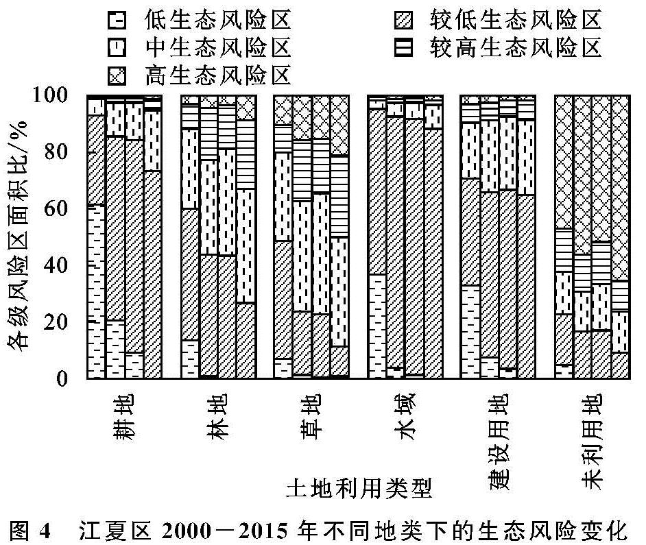
3.2.4 不同土地利用类型下的生态风险演变规律 分别将每一期的土地利用类型图与生态风险等级图进行叠加,统计汇总出每种土地利用类型下各生态风险等级所占的面积比例(图4)。2000年有92.8%的耕地分布在低生态风险区和较低生态风险区,2015年下降到73.33%。林地、草地景观类型主要分布的较高和高生态风险区占比不断加大。水域景观主要分布在较低生态风险区,主要是因为其干扰度和损失度较小,所受生态风险较低。建设用地主要分布在较低生态风险区和中生态风险区,且随时间变化较高生态风险区和高生态风险区占比有减小趋势。原因是随着城市化发展,建设用地从无序零散状态向有序规模演变,系统内部稳定性提高,受人类干扰后损失度降低,导致生态风险的降低。未利用地2000年有46.8%的面积分布在高生态风险区,到2015年其比重达到65.5%,主要原因是未利用地干扰度、脆弱度和损失度指数均较高,且随时间呈递增态势,表明未利用地的生态风险系数不断提高,需要加强保护监管力度。
图4 江夏区2000-2015年不同地类下的生态风险变化
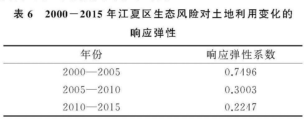
3.2.5 生态风险对土地利用变化的响应弹性分析
由表6可知,生态风险随着土地利用变化的响应弹性在不同时段内其响应效果也呈现差异变化。3个时期生态风险对土地利用变化均表现为正响应,即土地利用变化造成了生态风险的增加,且3个时段响应弹性系数持续减小,表明研究区内土地生态系统风险水平趋于稳定,土地利用变化不再是作为区域生态风险增加的主要驱动因素,虽然随着城市化的快速发展,耕地的大规模转出,造成江夏区内生态风险强度不断增加,但其对土地利用变化的响应弹性却表现为不断减小,土地利用生态风险的影响因子由于更加复杂多变的外在环境而趋于多元化。
表6 2000-2015年江夏区生态风险对土地利用变化的响应弹性