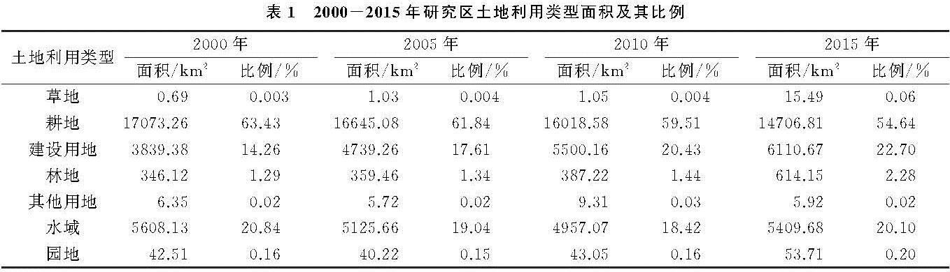
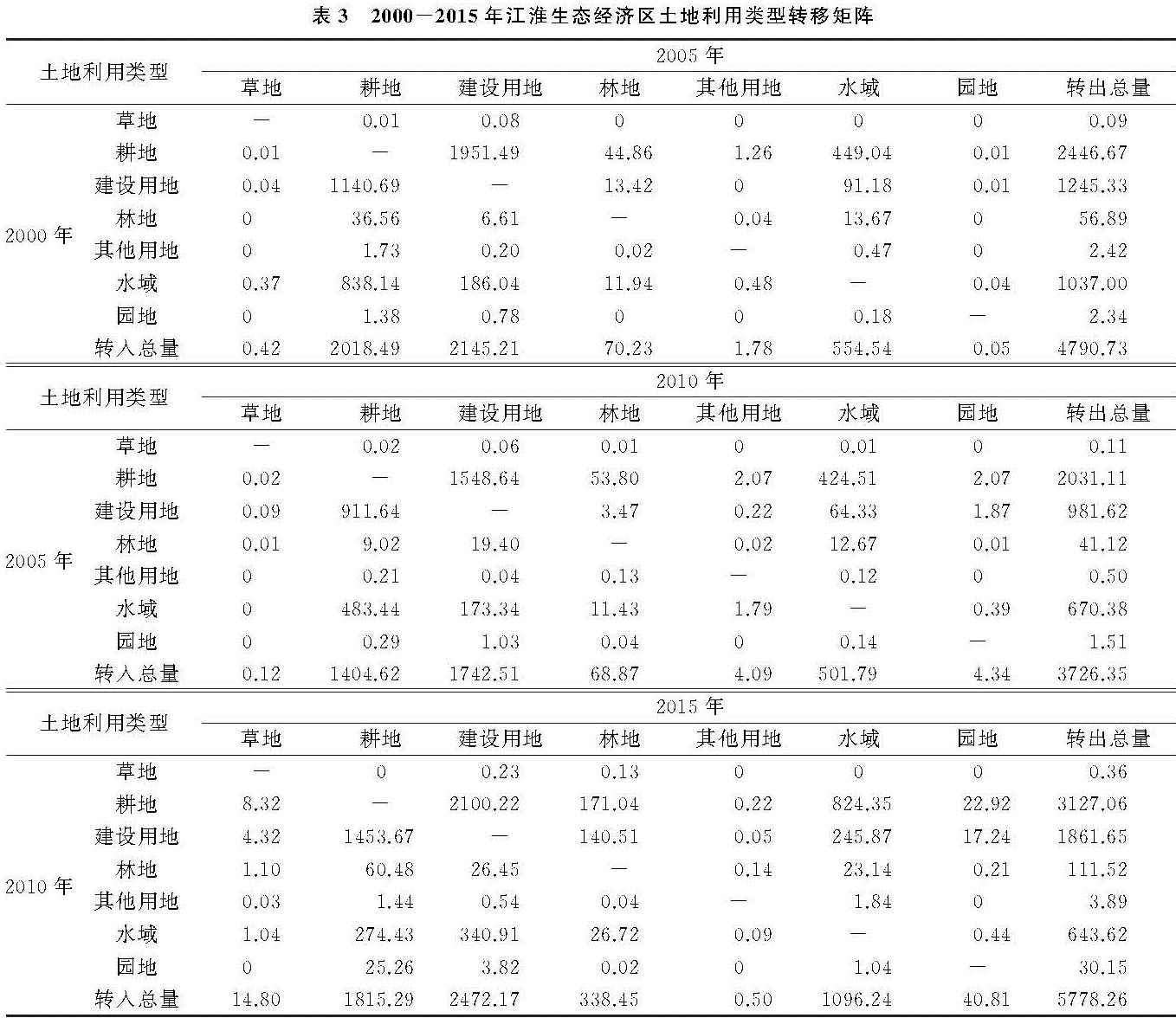
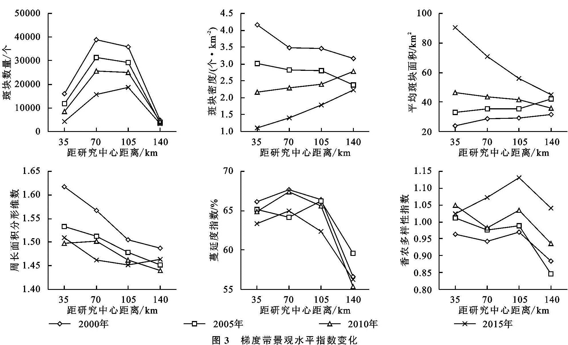
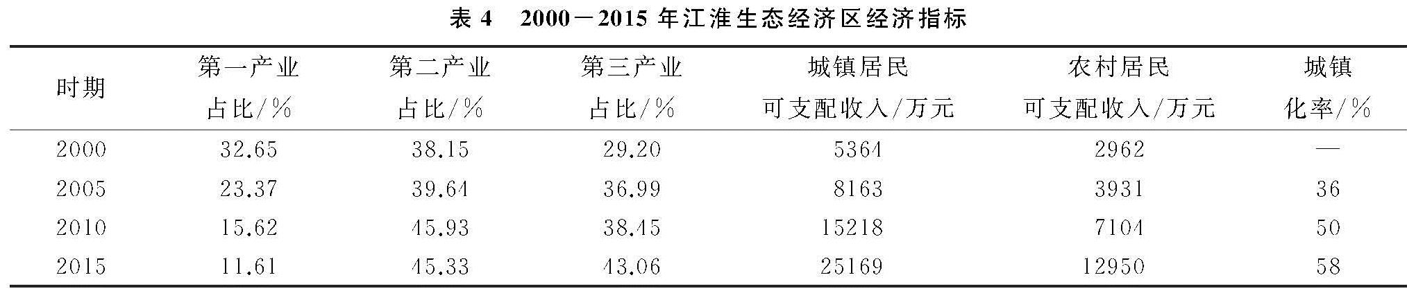
土地利用的变化与城市化、社会经济的发展以及制度政策关系密切。耕地和建设用地的变化主要与人口的增加和经济发展有着密不可分的关系。据统计,江淮生态经济区城镇化率由2005年的36%增长至2015年的58%,城镇居民可支配收入2000年仅为5 364元/人,到2015年增长至25 169元/人,而农村居民可支配收入从2 962元/人增长至12 950元/人(表4),表明城镇居民生活水平提高显著。随着人口总量的增加,人口结构发生改变,非农业人口不断增加,城镇化率不断提高,导致耕地面积持续减小,转变为建设用地。农村居民收入在一定程度上也影响着耕地面积的变化。2000—2015年耕地始终占据江淮生态经济区的主体地位,农民是区域人口的主体,农村居民的可支配收入呈上升趋势。根据调查,农村居民收入来源以外出打工为主,不再依靠农业生产为此,因此导致耕地面积的减少,而外出打工的农村居民进一步带动建设用地的扩张,使得部分耕地被占用。
从表4可以看出,江淮生态经济区产业布局以第二产业为主,随着时间的不断推进,二、三产业迅速发展,第一产业占比呈下降趋势。2000—2015年江淮生态经济区地区生产总值迅速增长,经济增长的态势带来了区域建设性投资,进而为城镇扩张提供条件。城镇居民生活水平的显著提高以及二、三产业的迅速发展均增加了对建设用地的需求,进而加速了城镇化的进程。而二、三产业的快速发展吸引更多的人来该地区工作,需要更多的建设用地来支撑,由此进一步推动建设用地的增加。耕地是江淮生态经济区的优势土地利用类型,其面积持续减少,但仍占据较高的比例,破碎化程度不断降低,形状趋向简单,城镇用地在空间上集中分布,呈扩张趋势,因此要做好保护基本农田和控制城镇扩张规模,加强维护自然生态系统的连接性。
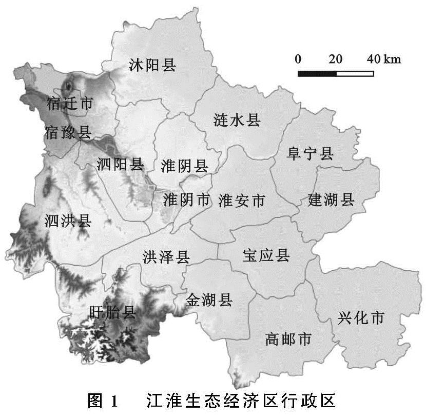
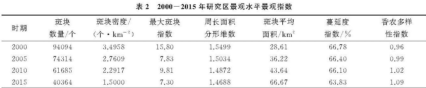
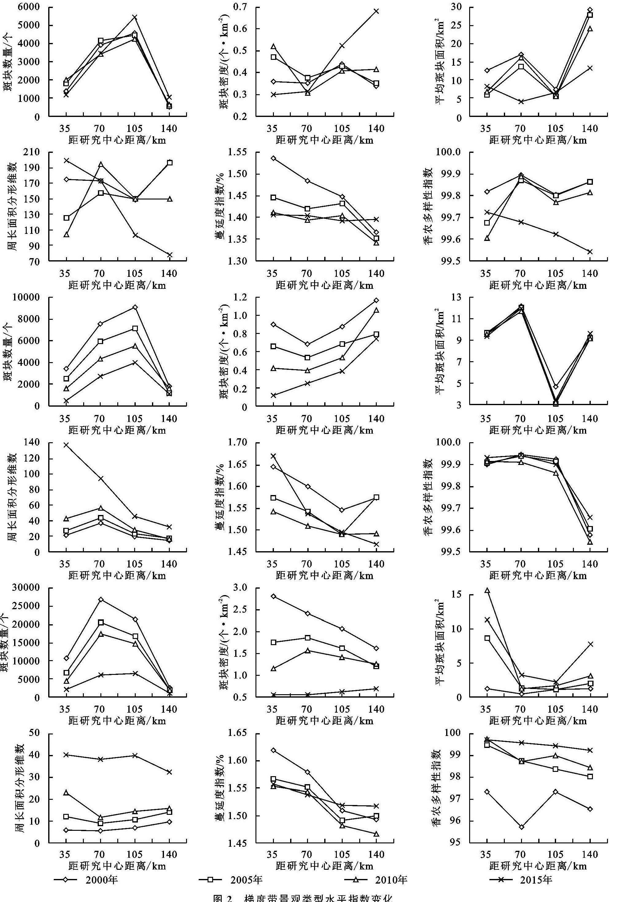
水是江淮生态经济区的灵魂,区域内拥有洪泽湖、高邮湖、骆马湖和白马湖等大型湖泊,水网密布、水资源丰富。2000年以来,随着经济快速发展,人口不断增加,人们对耕地的需求日益增加,从而对湖泊进行围垦、圈圩。过渡的围垦、大面积的圈圩以及非法采砂活动导致湖泊大幅萎缩,泥沙淤积,水体富营养化,水质退化和生物多样性降低等生态环境问题。自2006年以来,随着政府退圩还湖和打击非法采砂等政策的逐步实施,洪泽湖、白马湖、骆马湖和高邮湖的围网围垦养殖得到有序管理,非法采砂得到有效遏制,水域面积增加显著,水质得到提高,生态环境有了极大的改善,地区生态环境安全得到保障。近15 a来,水域的破碎化程度加大,形状复杂程度不断增加,将对其生态系统服务功能造成严重的影响。
研究江淮生态经济区的土地利用格局变化,吸取其经验和教训,以促进区域社会经济和环境可持续发展。尽管退圩还湖等政策取得显著成效,但江淮生态经济区湿地萎缩、水域资源被过度占用、生态服务功能退化等问题仍然存在,将制约着区域生态、经济的可持续发展。因此,加强水资源的保障和恢复显得尤为重要。为保护区域水资源,统筹水资源、水环境和水生态系统治理,需采取以下生态发展对策:
第一、以洪泽湖、高邮湖、骆马湖等“三湖”为核心,以京杭运河、通榆河、苏北灌溉总渠、废黄河“四河”为重点,构建水系主骨架。既加强湖泊湿地的岸线维护和植被恢复,也在南水北调东线工程的水质保障下,严格保护清水通道维护区,推进生态廊道建设,带动生态空间整体修复。
第二、以南水北调东线输水通道为骨架,以区域性骨干河道为基础,以城乡内河为补充,构架格局合理、互联互通、功能完备、标准较高的疏水活水网络。有效沟通水系,保障生态基流,保留和提升河道自然美,改善区域行洪、治涝、供水、活水条件。
第三、从湖泊面积、水环境安全、生态服务功能、人类活动影响等方面出发,多角度、长时序、多维度地开展“三湖”水资源水环境综合评估,明确“三湖”的健康水平变化规律,也对围网养殖、采砂、围垦等关键人类活动对水域的影响进行定量化评估。以评估结果为依据,按照“一湖一策”原则,从水源涵养、生态清淤、湖滨带景观、人类活动限制区域划定等方面制定水域保护方案,保护水生态系统完整性,确保良好的水质和生态服务功能。