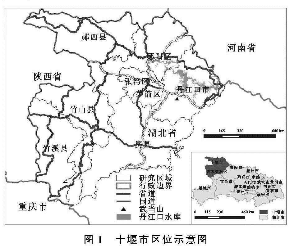
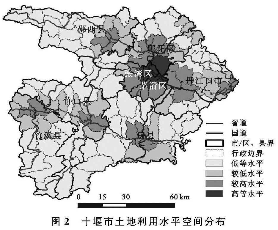
3.1 十堰市土地利用水平的空间特征分析
从图2可知,十堰市土地利用水平整体呈现出以十堰市主城区为核心向周围递减,并在各县城心出现次高峰的空间分异规律,研究结果基本吻合十堰市 “东拓,西进,中优”的发展规划。其中高等水平区占总面积的2.5%,主要集中分布在张湾和茅箭的中心城区,小部分分布在郧阳区的茶店镇和丹江口市的均州路街道,这些区域作为十堰市的城镇密集发展地带,经济发展程度较高,是十堰市经济、商贸、工业和文化教育活动设施集中分布的地区; 较高水平区占总面积的15.44%,主要分布在十堰市主城区的城郊地带以及各县的中心城区,近年来随着十堰市城市化的扩张,在十堰市主城区的辐射带动下,城郊地带的各类基础设施和工业企业的建设日益完善,大幅度提升这些区域的土地利用水平,而城乡统筹、城乡一体化的发展战略,则为十堰市的县域经济的发展提供了较好的契机; 较低水平区占23.14%,主要镶嵌分布在县域中心城区的周围地带,这些区域的基础设施和各类工商业发展水平落后; 低等水平区占总面积的58.92%,主要分布郧西县的中西部山区、郧阳区的西北部山区、丹江口市北部的水源涵养和水土流失治理区。以及竹溪、竹山和房县南部以中低山林牧区与高山区。这些地区以山地地形为主,基础设施建设薄弱,经济发展水平较弱,土地开发利用水平较低。
3.2 景观生态风险的空间特征分析
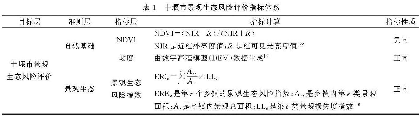
景观生态风险评价能够反映限制区域生态可持续发展的主要因素和过程,是现阶段区域资源管理、景观生态环境修复等相关工作和诸多决策制定的重要依据。从附图4可知,十堰市高生态风险区分布范围小,仅占总面积的2.44%。主要分布在张湾区、茅箭区以及丹江口市的中心城区,这些区域人类对于景观的干预程度大,景观破碎程度高。加之承载着以汽车制造业为主的一系列重工业的发展,加剧了当地的生态环境压力; 小部分分布在丹江口水库生态移民大镇的均县镇,该区域分布着南水北调中线源头的丹江口水库,主要以脆弱度较高的水域景观为主,景观类型单一,加上大量水库移民的迁入和湖泊对于外界风险较为敏感,受人为干扰作用强的特性,使得该地景观生态风险水平高; 较高生态风险区占总面积的17.22%,主要分布在竹溪、竹山和房县南部的中低山林牧区,这些区域位于大巴山地,地形起伏大,存在地质灾害隐患。落后的经济发展水平和较低的教育发展水平,使得当地居民缺乏可持续发展的意识,过度放牧与开垦加剧了当地的生态环境恶化; 部分分布在城郊地带、县域的中心城区,在这些区域人类的开发建设活动使得大量原有植被与耕地被占领,耕地和草地的破碎度增加,造成了干扰度和景观生态风险的提高; 十堰市较低生态风险区和低生态风险区分布范围广泛,分别占总面积的55.63%和24.71%。主要包括郧西、郧阳和丹江口市大部分地区、张湾西北部和茅箭区东南部地区,以及竹溪、竹山和房县的北部地区。郧阳区的东南部丹江口市的大部分地区,以低山丘陵为主,坡度较小,加之是丹江口水库上游的重要生态涵养区,退耕还林的成效显著,环境效益大幅提升; 其他区域景观类型则以林地和耕地为主,林地占比大,植被覆盖度高。而且研究区域内的林地种类丰富,以林、灌、疏林地为主,生态系统结构稳定,脆弱度低。加之这些区域以山地地形为主,人类活动干扰较少,生态环境相对稳定。
3.3 土地利用水平与景观生态风险的空间耦合分析
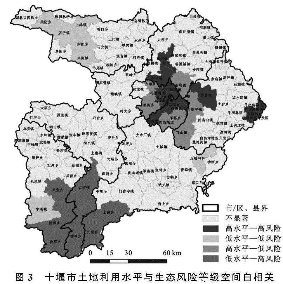
从人和自然耦合关联的视角出发,科学分析人类对于土地的各类开发建设活动对于特定区域的景观生态系统所造成的压力和胁迫,是有效规避、主动适应和综合管理景观生态风险的有效途径。因此研究基于GeoDA软件平台,利用双变量空间自相关模型,来分析十堰市土地利用水平和景观生态风险的空间耦合特征。计算得出十堰市全局Moran's I指数为0.322(p=0.01,Z=8.060 3,大于2.58,通过了显著水平检验[27]),表明研究区域内土地利用水平与景观生态风险之间存在正向的空间关联性。为了进一步揭示土地利用水平与景观生态风险等级高值与低值的空间集聚情况,明晰局部的空间差异性,借助LISA对土地利用水平和景观生态风险进行局部空间自相关分析,结果见图3。
高水平—高风险区:是指土地利用水平高,同时景观生态风险等级高的地区。主要分布在茅箭、张湾郧阳和丹江口市的中心城区及城郊地区,占总面积的5.43%。这些区域的交通和经济区位条件好,316国道和福银高速在这一带通过,交通便利,产业基础雄厚,是十堰市工业化和城市化发展的重点区域。但同时也面临着建设用地扩张,耕地和草地景观被占,植被覆盖度降低,景观破碎度增大,生态风险等级高的困境。小部分则分布在丹江口市的均县,作为生态和库区移民重点区域,均县的发展获得了较高的政策和资金支持,现有基础设施建设和各类工业企业发展水平仅次于中心城区,但是大量的人口迁入,以及区域内较为单一的景观类型对于当地的自然生态环境带来较大的压力。
低水平—低风险区:是指土地利用水平和景观生态风险等级都低的区域,主要分布在郧西县的西部地区、房县的万峪河乡以及竹溪县的丰溪镇,占总面积的7.2%。这些区域主要以林地景观类型为主,自然生态系统结构较为稳定,加之落后的基础设施建设使得该地各类工商业发展较慢。
高水平—低风险:是指土地利用水平较高,但景观生态风险较低的区域。主要分布在张湾区的方滩乡、西沟乡,茅箭区的武当街道、茅塔乡,丹江口的六里坪镇、官山镇以及郧阳区的茶店镇,占总面积的11.51%。是十堰市作为鄂西生态旅游文化圈,重点打造的生态旅游发展基地,加之邻近主城区的优势地理区位使得这些区域的基础设施建设以及土地的开发利用水平都相对较高,而且作为生态文化旅游的服务基地使得这些区域的生态环境保护较好。
低水平—高风险:是指土地利用水平较低,但景观生态风险较高的区域。主要分布在竹溪、竹山和房县南部的中低山林牧区,占总面积的5.42%。在农业的发展过程中,大量的林地被开垦成耕地,加之农村居民点松散式的的建设布局,会随着人口的增长而呈现出外延式的无序增长侵占了原本自然生态下的自然化土地。低效的土地开发建设活动既没有带来土地利用经济效益的提升,反而加剧了生态环境问题的紧迫性。
不显著区:区域内土地利用水平和景观生态风险等级集聚关系不显著的地区。占总面积的70.44%,主要分布在县域中心及周围地区,主要景观类型为林地和跟耕地,土地利用水平与景观生态风险等级相对均匀,没有明显的高值和低值中心。