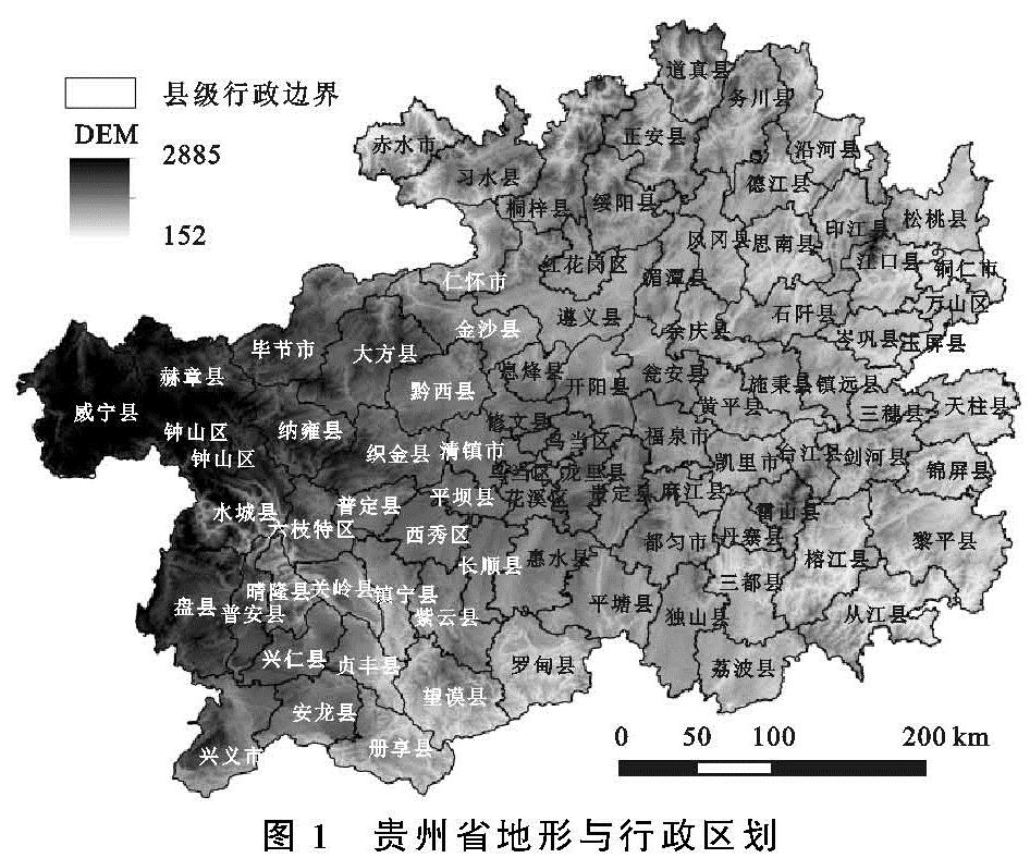
2.2.1 总面积变化
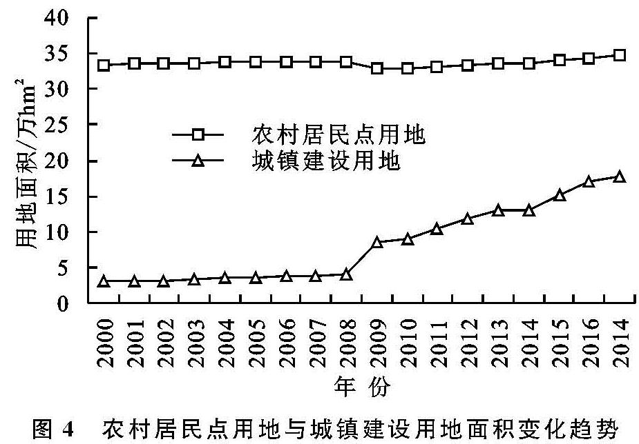
(1)时序特征。2000—2017年,农村居民点用地呈增长趋势。2000—2008年为缓慢增长期,农村居民点用地从33.48万hm2增长到33.92万hm2(图4),增加了0.44万hm2,年均增加0.055万hm2,年均增长率约为0.16%。同期城镇建设用地面积由3.04万hm2增加到4.02万hm2,共增长0.98万hm2,年均增长0.122 5万hm2,年均增长率为4.03%。2009—2017年为较快增长期,农村居民点用地面积由32.80万hm2增加到34.77万hm2,8 a来共增加1.97万hm2,年均增长约0.25万hm2,年均增长率约为0.75%,增长速度快于前一时段。同期,城镇建设用地面积增加约9.24万hm2,是农村居民点用地增长面积的4.69倍。城镇建设用地与农村居民点用地面积双增态势明显,给土地利用造成了巨大压力。
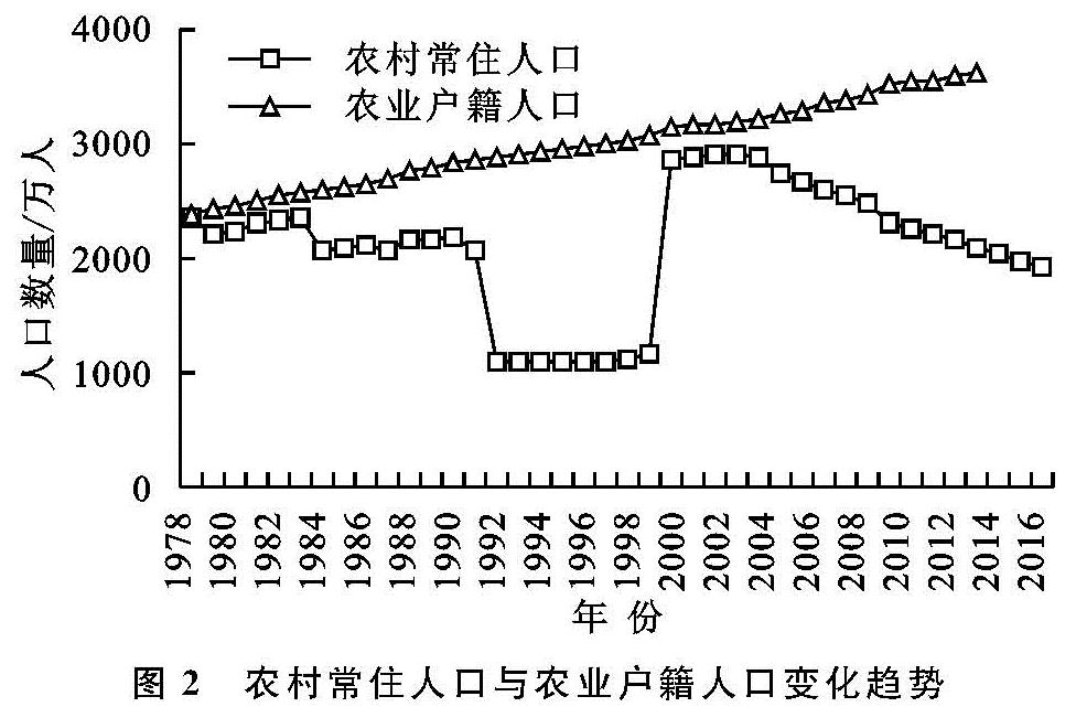
2000—2008年,城镇年末常住人口增加150.30万人,农村年末常住人口减少310.02万人。2009—2017年,城镇年末常住人口增加590.31万人,农村年末常住人口减少547.31万人。城镇人口增长是引起城镇建设用地增长的原因之一,但由于城乡隔离、土地管理及社会保障制度,不彻底的城镇化发展模式、叶落归根传统思想的存在,加上农民经济收入提高,建房能力提升,导致农村地区大量“建新不拆旧”、宅基地闲置浪费严重、一户多宅的现象普遍存在。虽然农村常住人口减少,但农村居民点用地持续扩张,未能实现城市建设用地增长和农村建设用地减少同步。贵州省的情况明显与近年来试行的增减挂钩政策不符合,急需开展居民点用地整理。
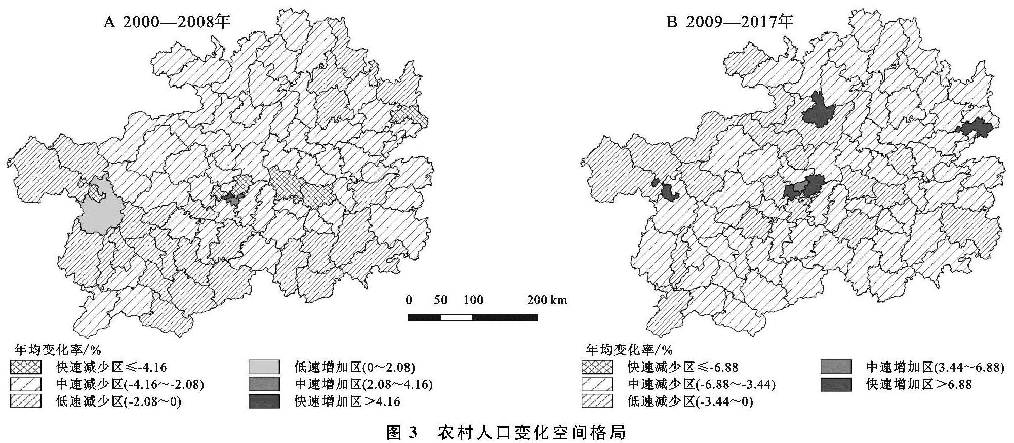
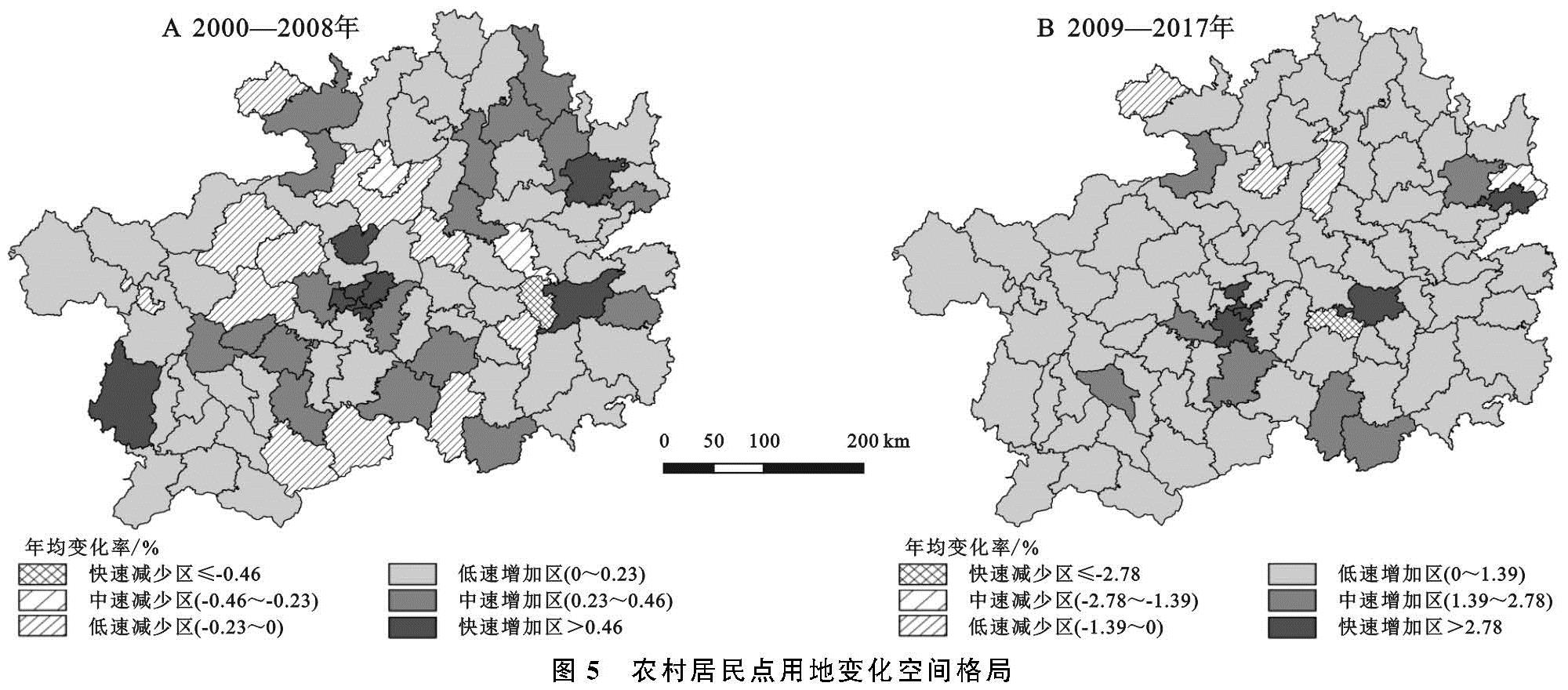
(2)空间格局。2000—2008年,农村居民点用地年均变化率的平均值为0.23%,略增加。全省农村居民点用地空间格局变化各异(图5A)。(1)快速减少区仅台江县1个区县,年均变化率≤-0.46%;(2)中速减少区包括红花岗区、施秉县2个区县,年均变化率-0.46%~-0.23%;(3)低速减少区随机分布,包括赤水市、遵义县等11个区县,年均变化率-0.23%~0%;(4)低速增加区有花溪区、开阳县等46个区县,年均变化率0%~0.23%;(5)中速增加区有清镇市、六枝特区等18个区县,年均变化率0.23%~0.46%;(6)快速增加区包括南明区、云岩区等8个区县,年均变化率大于0.46%。开展的城乡建设用地“增减挂钩”和农村居民点整理是部分区县农村居民点用地减少的重要原因。
2009—2017年,农村居民点用地年均变化率平均值为1.39%,较2000—2008年增幅有所上升,各区县变化趋势有所差异,绝大部分区县的农村居民点用地都处于增长状态(图5B),2017年有5个区县农村居民点面积较2009年有所减少。(1)快速减少区只有麻江县1个区县,其年均变化率≤-2.78%;(2)年均变化率介于-2.78%~-1.39%之间的中速减少区仅铜仁市1个区县;(3)红花岗区、湄潭县、赤水市3个区县农村居民点用地有小幅减少,年均变化率介于-1.39%~0%;(4)乌当区、开阳县等68个区县农村居民点面积增速略小于全省平均水平,为低速增加区;(5)仁怀市、平坝县等7个区县年均变化率为1.39%~2.78%,为中速增加区;(6)南明区、云岩区等6个区县年均增速超过2.78%,为快速增加区。这是由于在当今的社会背景下,农村居住用地的集聚程度不高,土地浪费现象严重。面对喀斯特山区日益突出的人地矛盾,厘清人口与建设用地变化的关系,促进土地资源优化配置势在必行。
2.2.2 人均面积变化
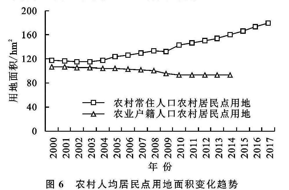
(1)时序特征。从图6可以看出,常住人均居民点用地从117.11 m2增加到179.94 m2,共增加了62.83 m2,年均增加约3.7 m2; 农业户籍人口人均居民点用地呈持续减少趋势,从2000年的106.47 m2减少到2014年的93.24 m2,共减少了13.23 m2,年均减少0.945 m2。人均居民点用地面积的增减与农村居民点用地总面积的变化、农村人口的变化有关。农村人口减少伴随着建设用地增加,农村人地关系处于较为不合理状态; 城镇人口和建设用地都增长,但建设用地增幅快于人口增幅,因此城镇人均居民点用地也呈增长趋势。
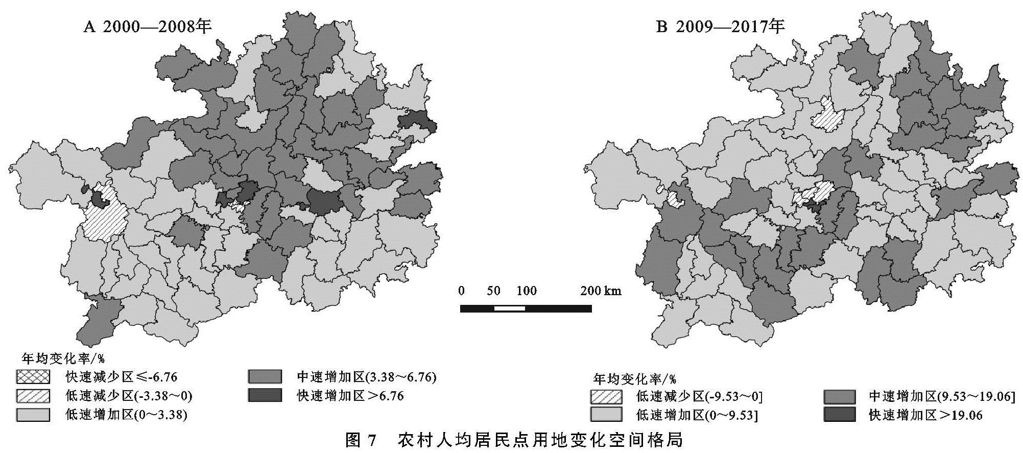
(2)空间格局。2000—2008年,县域人均居民点用地年均变化率平均值为3.38%,呈增加趋势。减少区零星分布,大部分区县呈增加趋势,以低速增加和中速增加为主(图7A)。(1)仅云岩区的农村常住人口人均居民点用地呈快速减少,年均减少速度大于-6.76%;(2)无中速减少区;(3)南明区、水城县2区县呈略减少趋势,年均变化率-3.38%~0%;(4)略有增加区包括花溪区、清镇市等43个区县,其年均变化率略低于全省平均水平(3.38%),主要分布于黔西北与黔东南;(5)中速增加区主要分布在中部和东北部地区,其增速略高于全省平均水平,包括白云区、开阳县等36个区县;(6)快速增加区则形成“四点格局”,包括乌当区、钟山区、铜仁市和凯里市4个区县,其年均变化率为3.38%~6.76%。
2009—2017年,贵州省各县人均居民点用地年均变化率的平均值为9.53%,呈增加趋势,较之上一时段增长更快。95.35%的区县呈现增加的趋势,以低速增加和中速增加为主(图7B)。(1)无快速减少区和中速减少区;(2)低速减少区包括乌当区、白云区、钟山区和红花岗区4个区县,其年均变化率为-9.53%~0%;(3)低速增加区包括花溪区、息烽县等52个区县,其年均变化率介于0%~9.53%;(4)中速增加区包括开阳县、六枝特区等28个区县,年均变化率为9.53%~19.06%;(5)快速增加区仅南明区、云岩区2个区县,其年均变化率大于19.06%。
随着经济迅猛发展,农民开始大量建房,农村人均居民点用地大量增加。且2009—2017年较2000—2008年来说经济增长更快,人均农村居民点用地增加更多。
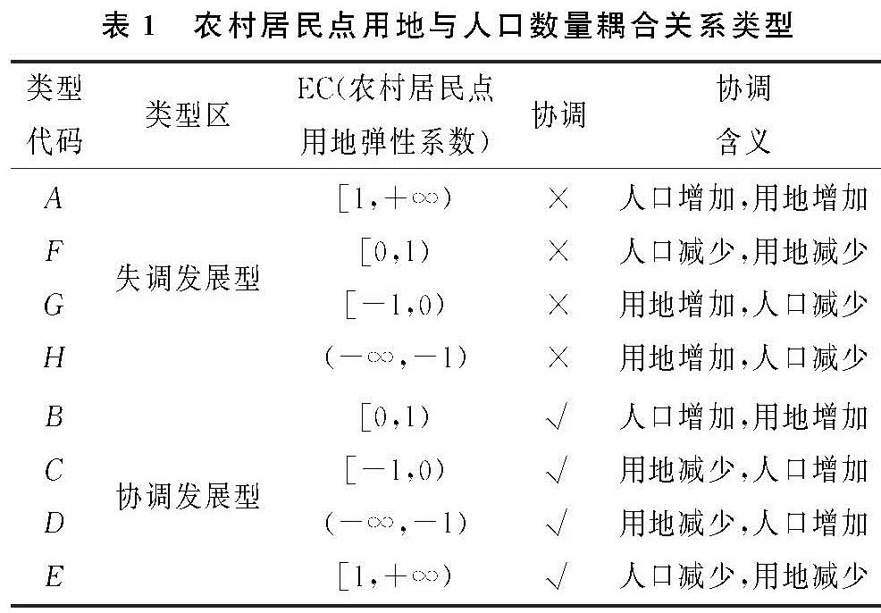
2.3 人地变化的时空耦合类型
2.3.1 时序耦合类型
2000—2008年,贵州省农业户籍人口与农村居民点用地为B类协调发展类型。即农业户籍人口与农村居民点用地同时增加,用地增速更慢,因而人均居民点用地减少,土地利用效率较高。
2000—2008年与2009—2017年两个时段,贵州省农村常住人口与农村居民点用地均为G类失调发展类型。即农村常住人口快速减少,农村居民点用地面积不减反增,土地利用效率相对低下。
2.3.2 空间耦合类型 在县域尺度上,分析表明:
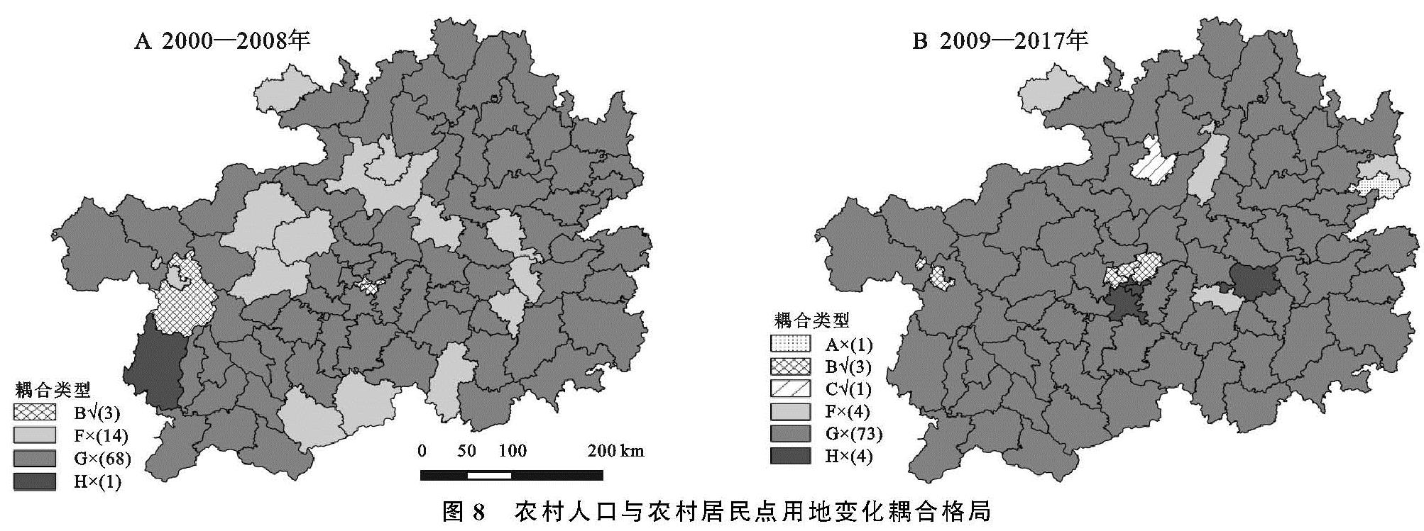
(1)2000—2008年,贵州省约96.51%的区县农村居民点用地与乡村人口耦合类型都属于不协调发展类型,以G类失调发展类型为主(图8A)。(1)无A类、C类、D类和E类发展类型;(2)B类协调发展区县包括南明区、云岩区、水城县3个区县,占比3.49%;(3)钟山区、红花岗区等14个区县属于F类失调发展类型,占比16.28%;(4)G类失调发展区县包括花溪区、乌当区等68个区县,占比79.07%;(5)H类失调发展区县仅有盘县1个区县,占比1.16%。这一时段,大部分区县农村居民点用地减少速度低于农村常住人口减少速度,或农村居民点用地增加速度低于农村常住人口减少速度。
(2)2009—2017年,贵州省约95.35%的区县农村居民点用地与乡村人口耦合类型都属于不协调发展类型,以G类失调发展类型为主(图8B)。(1)无D类和E类发展类型;(2)仅万山区1个区县属于A类失调发展类型,占比1.16%;(3)乌当区、白云区、钟山区3个区县属于B类协调发展类型,占比3.50%;(4)仅红花岗区1个区县属于C类协调发展类型,占比1.16%;(5)F类失调发展类型包括湄潭县、赤水市等4个区县,占比4.65%;(6)G类失调发展区县包括开阳县、息烽县等73个区县,占比84.88%;(6)此外,南明区、云岩区等4个区县属于H类失调发展类型,占比4.65%。这一时段,大部分区县农村居民点用地增加而农村常住人口数量减少。
综合来看,贵州省大部分区县农村居民点用地与农村常住人口呈现不协调发展趋势。在城乡转型发展进程中,农村常住人口快速减少,农村居民点用地面积不减反增,土地利用效率较为低下。