3.1 插值方法精度比较
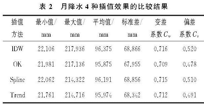
通过交叉验证对4种方法插值的MAE,MRE和RMSE的对比分析(图2),结果表明:月降水量的MAE的排序为IDW>Trend>Spline>OK,其值依次为13.59,12.41,11.83,10.72。MRE和RMSE的排序与MAE的排序一致,MRE的值分别为0.15,0.13,0.13,0.12,RMSE的值分布为15.83,15.12,14.56,13.50。4种方法的MAE,MRE和RMSE的变化都呈现出明显的季节性,MAE和RMSE整体表现为秋冬两季低于春夏两季,从1月到7月,MAE和RMSE的值呈上升趋势,7月至12月呈下降趋势。MRE月值变化情况较为特殊,表现为冬季和夏季较高,春季和秋季较低。根据MAE,MRE和RMSE的结果可知,4种插值方法在贵州省普遍得到精度较高的空间降水信息,MAE和RMSE的误差春夏两季低于秋冬两季,MRE的误差在春季和秋季较低。总体来看,4种插值方法误差值排序为IDW>Trend>Spline>OK,即OK法的3项评价指标值最低,可得贵州省月降水插值来说OK法的降水插值结果精度最高。故对这一结果作进一步的分析发现(表2),通过4种插值方法获得的贵州省近59 a的月平均降水量基本一致,标准差、变差系数和偏差系数都是OK法插值数值最小,充分说明普通克里金插值精度最好[27]。
贵州省近59 a的月均降水量为96.27 mm,春季、夏季、秋季、冬季的平均降水量分别为101.14 mm,182.90 mm,77.87 mm,23.17 mm,从高到低排序为夏季>春季>秋季>冬季,秋冬两季的降水量少,4种方法在秋冬两季的MAE和RMSE值均较小,夏季降水起伏较大,使得MAE和RMSE的值较大,采用空间插值方法不能有效地模拟降水情况。可看出月降水量的变化趋势与MAE和RMSE的走向大致一样,可推测随着降水量的增加,MAE和RMSE值也会增加。
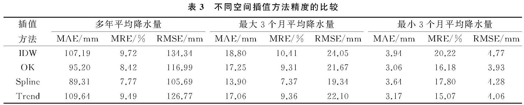
3.2 误差分析
从表3可以看出,对于贵州省而言,年均降水量插值精度最高的是Spline样条函数插样法,其MAE,MRE,RMSE分别为89.31 mm,7.77%,105.69 mm; 其次为普通克里金插值OK法,其MAE,MRE,RMSE分别为95.20 mm,8.42%,116.99 mm; 插值精度最低的是趋势面法,Trend法的MAE,MRE,RMSE分别为109.64 mm,9.49%,126.77 mm,即对于年降水来说,4种方法在MAE上的排序为Trend>IDW>OK>Spline,在MRE,RMSE的排序为IDW>Trend>OK>Spline; 最大3个月平均降水插值中,MAE上的排序为IDW>OK>Trend>Spline,MRE,RMSE上的排序为IDW>Trend>OK>Spline; 最小3个月平均降水量的插值中,MAE,RMSE上的排序为IDW>Spline>Trend>OK,MRE上的排序为IDW>Spline>OK>Trend。
综合MAE,MRE,RMSE,整体来说,在贵州省年降水和最大3个月平均降水量的插值中,Spline的3种评价指标值均最小,IDW的指标值最大,说明Spline法的插值效果最好,IDW法的效果较差,即Spline>OK>Trend>IDW,最小3个月平均降水量插值方法精度OK>Trend>Spline>IDW。
图2 4种插值方法对贵州省1960-2018年降水的MAE,MRE和RMSE对比分析
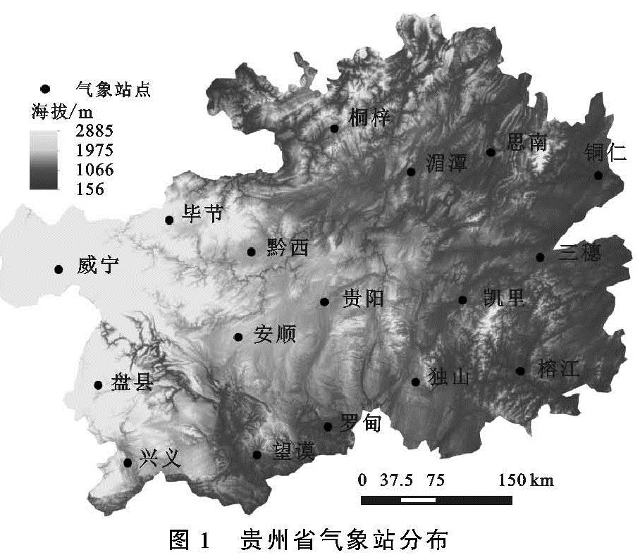
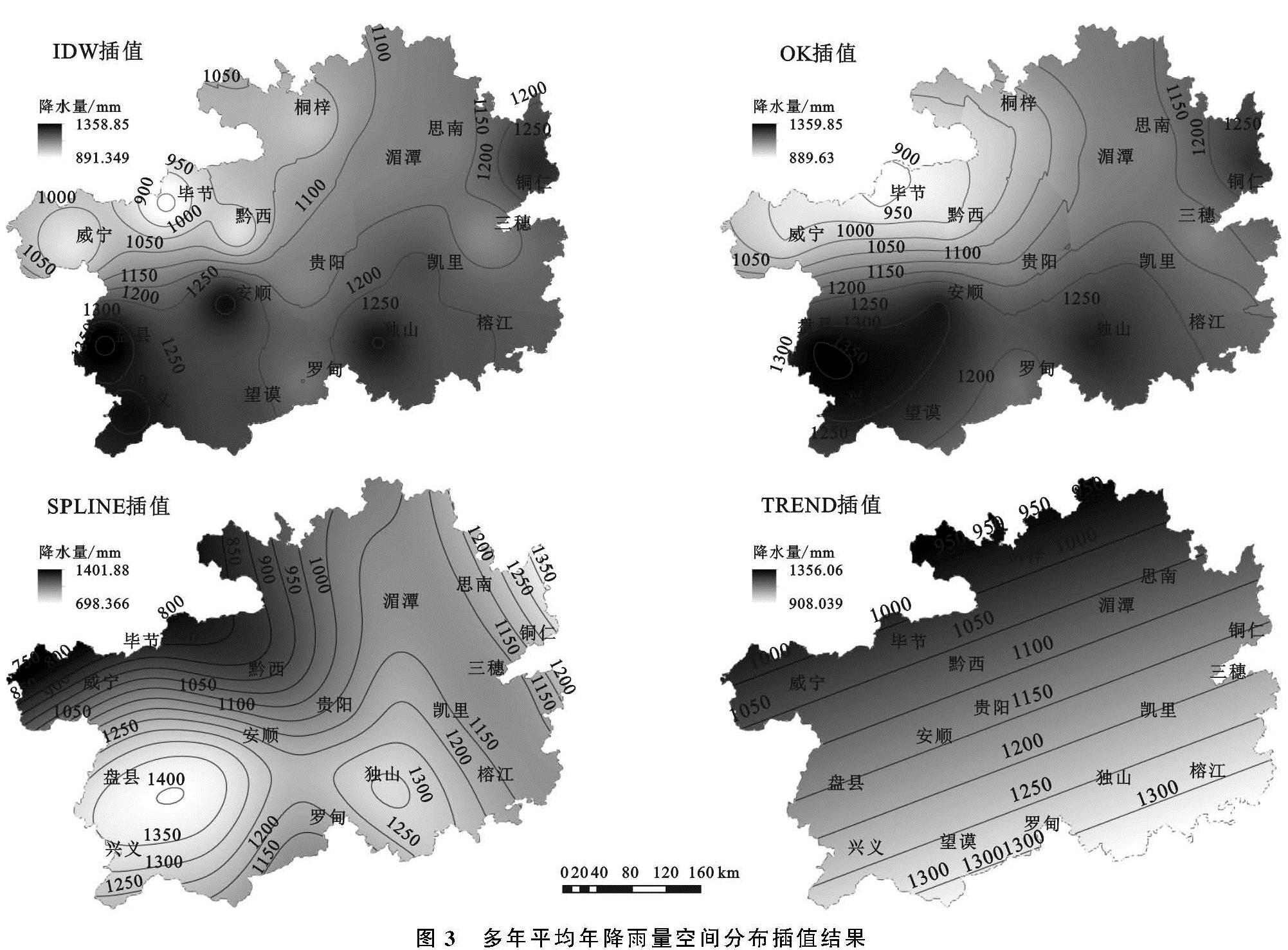
3.3 降水插值结果空间分布特征
通过对17个站点的年均降水数据分别采用不同的插值方法生成降水表面栅格图(图3),插值结果的参数均为系统默认参数。从图中可以看出:4种插值方法整体上反映出,贵州省多年平均降水量的空间分布纬度地带性比较明显,大体呈自南向北递减的规律。贵州省年均降水量为891~1 359 mm,降雨量最高区域主要位于西南部,水量在1 250 mm以上,安顺~盘县一带达到了最高值,为1 358.85 mm。东北部的铜仁市是贵州省的次降水中心,年降水量在1 200 mm左右。中部的贵阳到湄潭、黔东南的三穗的降水量为1 100~1 200 mm之间。最低区位位于毕节地区,威宁—毕节一带降水量在1 100 mm以下,极易发生干旱现象[16]。
4种方法的年降水量插值结果显示:Trend法的插值效果最差,从南到北,降水量均匀递减,降水量等值线呈平行线,较为笼统,未能体现气象站降水分布的区域性特征。IDW,OK和Spline法插值结果比较相似,降水低值中心位于毕节地区,降水区域主要在西南部的安顺—兴义—盘县、南部的独山、东北部的铜仁一带,IDW法明显受到站点的影响[28],OK法的插值结果不太均匀,存在突变异常值,Spline法兼顾插值曲面的准确性与平滑度,其插值结果较为均匀,在空间分布上符合贵州省的实际情况,空间插值较好。