3.1 SPEI指数变化特征
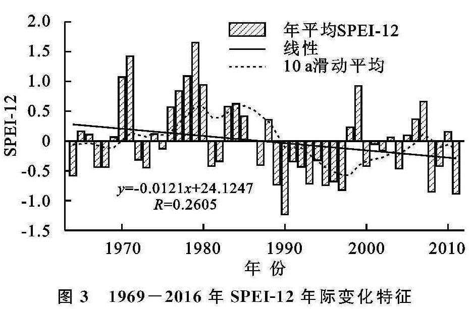
从年际变化看(图3),渭北黄土台塬区1969—2016年平均SPEI-12指数呈现明显的波动震荡,整体以0.012 1/a速率减少,说明渭北黄土台塬区干旱有增强趋势。年平均SPEI-12指数有明显波动特征,在1990年、2002年和2012年出现转折,呈“上升—下降—上升—下降”的波动趋势。渭北黄土台塬区1969—2016年干旱期主要集中在1994—2002年和2013—2016年,其中1995年和2016年干旱强度较大,年均SPEI-12指数分别为-1.23(中度干旱)、-0.89(轻度干旱); 相对湿润期主要集中在1974—1990年,年平均SPEI-12值数在1984年、1976年和1983年相对较大,分别为1.65,1.43,1.09。总的来说,48 a来渭北黄土台塬区干旱有增强趋势,且具有明显的波动特征,1974—1990年为相对湿润期,1994—2002年为干旱期。
图3 1969-2016年SPEI-12年际变化特征
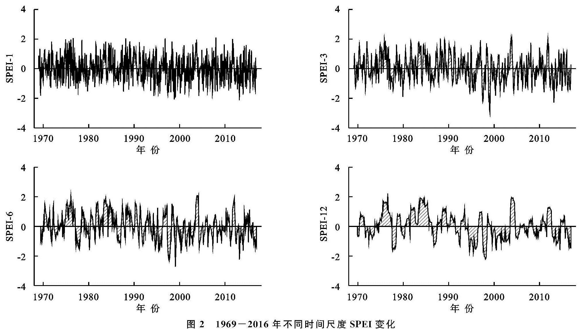
从季节变化看(图4),春、夏、秋、冬四季均呈下降趋势,下降速率分别为0.023 4/a,0.007 7/a,0.004 7/a和0.007 3/a,其中春季SPEI-3指数呈“上升—下降—上升—下降”的波动趋势,在2000年之后有变干旱趋势,干旱期集中在2000—2013年; 夏季SPEI-3指数波动幅度较小,无干旱年份集中在1978—1993年、1995年、1997年较为干旱; 秋季SPEI-3指数在1986—1999年以小于-0.5为主即以干旱为主,2000年以后干旱情况有所好转; 冬季SPEI-3指数波动幅度较小,多无干旱,湿润期主要集中在1971—1978年和2000—2012年。
图4 1969-2016年SPEI-3季节变化特征
3.2 干旱频率时空变化特征
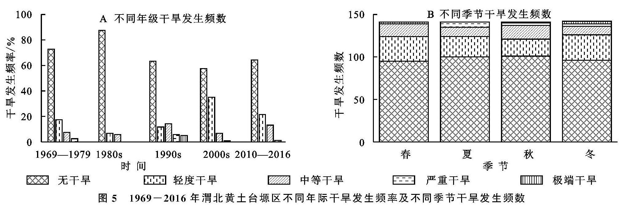
3.2.1 干旱频率时间变化特征 根据SPEI指数评估等级,选用SPEI-12对48 a来渭北黄土台塬区干旱事件发生频率进行统计分析,得到不同年代干旱发生频率和不同季节干旱发生频数(图5)。由图5A可知,渭北黄土台塬区1969—2016年无干旱和干旱发生频率分别为69.38%和30.62%,其中,干旱主要以轻度干旱为主(18.23%),中等干旱发生频率次之(9.20%),极端干旱最少(1.06%)。1980s干旱发生频率最小(12.50%),且无严重干旱和极端干旱发生; 1990s严重干旱和极端干旱发生频率均最大分别为5.83%和5.00%; 2000s干旱发生频率最大(42.5%)是干旱发生最少年代(1980s)的3.4倍。
由图5B可知,四季干旱频次整体上无较大差异,春季和冬季发生的干旱频次最多,均为46次; 其次为夏季(41次); 秋季最少(40次)。从不同干旱等级在四季内的分布情况可知,轻度干旱发生频次最多,中等干旱次之,极端干旱最少。此外,冬季发生轻度干旱和极端干旱次数均最多分别为30次和3次,夏季是发生严重干旱最多的季节(6次),秋季是发生中等干旱次数最多的季节(16次)。
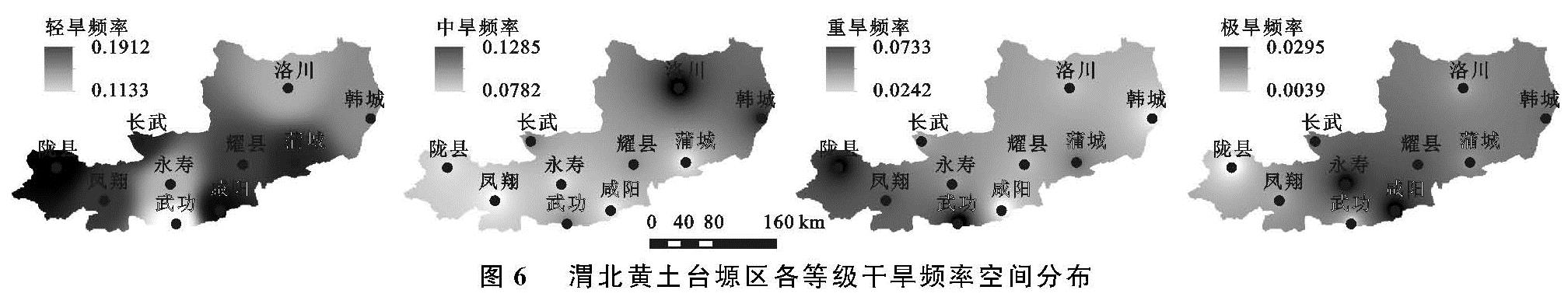
3.2.2 干旱频率空间变化特征 本研究以年尺度为例对渭北黄土台塬区不同等级干旱空间分布特征进行分析(图6)。由图6可知,不同等级干旱发生频率空间分布上有较大的差异。轻度干旱发生频率自西向东呈“高—低—高—低”的分布规律,其中,陇县轻度干旱发生频率最高(19.12%),武功发生频率最低(11.33%); 中等干旱发生频率自西向东呈“逐渐增高”的分布规律; 严重干旱发生频率自西向东呈“逐渐降低”的分布规律; 研究区域内极端干旱发生频率小于3%,发生频率相对较高的主要集中在永寿、咸阳、耀县,均位于研究区域中部,呈“中间高两边低”的分布规律,且东部略高于西部。
图5 1969-2016年渭北黄土台塬区不同年际干旱发生频率及不同季节干旱发生频数
3.3 干旱突变分析
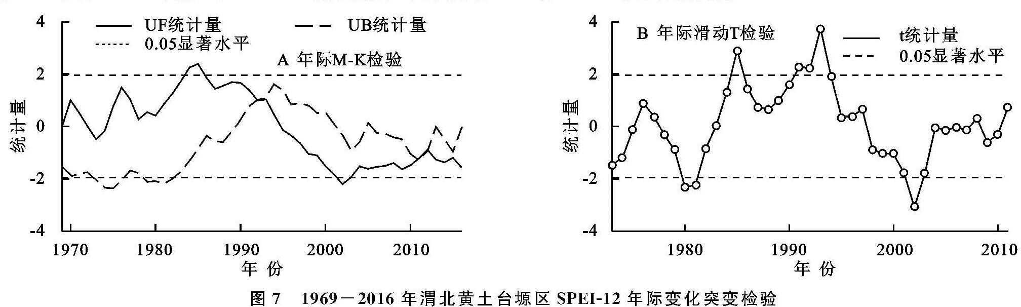
渭北黄土台塬区年平均SPEI-12指数年际变化M-K检验曲线(图7A)。UF曲线显示年平均SPEI-12指数经历了下降上升和下降的趋势,其中UF值在1969—1994年(除1973年、1974年)为正值,表明SPEI-12指数在此期间总体呈上升趋势,该时期为相对湿润期; 1994年之后,UF值均小于0,尤其2002年UF值(-2.21)超出�SymbolaA@�=0.05的置信区间,说明SPEI-12指数呈显著的下降趋势,该时期为相对干旱期。在�SymbolaA@�=0.05的置信区间内,UF和UB曲线相交于1991年、2010年、2012年,为精准确定突变年份,对SPEI-12指数进行滑动T检验(图7B),由图7B可知,在1991年、2010年、2012年3年中,仅1991年滑动T检验值超出�SymbolaA@�=0.05的置信区间,即在1991年存在显著突变,也表明了渭北黄土台塬区年际干旱自1991年开始加剧。
图7 1969-2016年渭北黄土台塬区SPEI-12年际变化突变检验
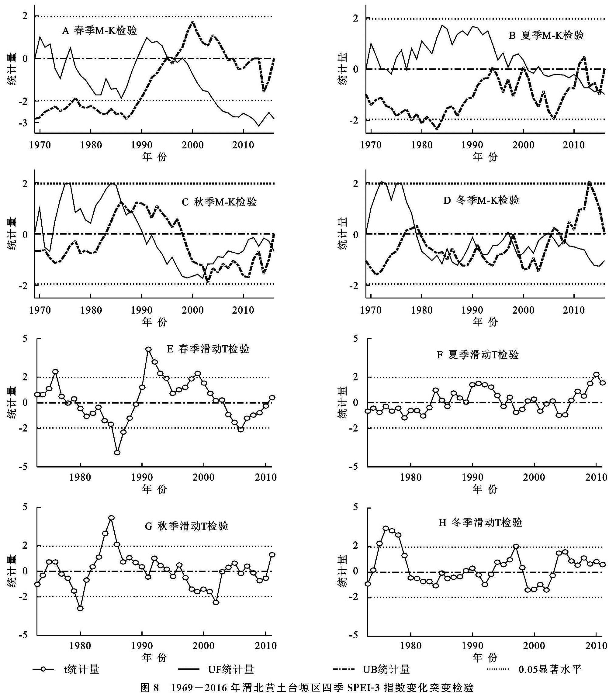
渭北黄土台塬区四季平均SPEI-3指数变化检验曲线(图8),由春季SPEI-3指数年际变化可知,在�SymbolaA@�=0.05的置信区间内,UF和UB曲线相交于1996年,且1996年滑动T检验值超出�SymbolaA@�=0.05的置信区间,即在1996年存在显著突变。由夏季SPEI-3指数年际变化可知,在置信区间内,UF和UB曲线相交于2010年、2014年、2015年,为精准确定突变年份,对夏季SPEI-3指数进行滑动T检验,仅2010年滑动T检验值超出�SymbolaA@�=0.05的置信区间,即在2010年干旱存在显著突变。
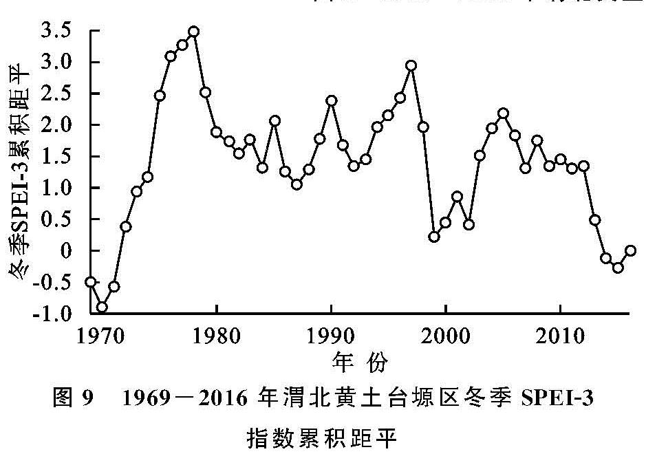
秋季SPEI-3指数的UF和UB曲线交点较多有1986—1988年、2002年、2015年,对秋季SPEI-3指数进行滑动T检验,仅2002年滑动T检验值超出�SymbolaA@�=0.05的置信区间,即在2002年干旱存在显著突变。冬季SPEI-3指数的UF和UB曲线交点有1978年、1987年、1997年等,对冬季SPEI-3指数进行滑动T检验,有1978年、1997年滑动T检验值超出�SymbolaA@�=0.05的置信区间,即在1978年、1997年干旱存在显著突变,为进一步确定更可能的突变点,对平均SPEI-3进行了累积距平分析(图9),结果表明冬季SPEI-3指数在1978年突变,综合考虑冬季在1978年存在显著干旱突变。
图8 1969-2016年渭北黄土台塬区四季SPEI-3指数变化突变检验
图9 1969-2016年渭北黄土台塬区冬季SPEI-3指数累积距平
3.4 干旱周期分析
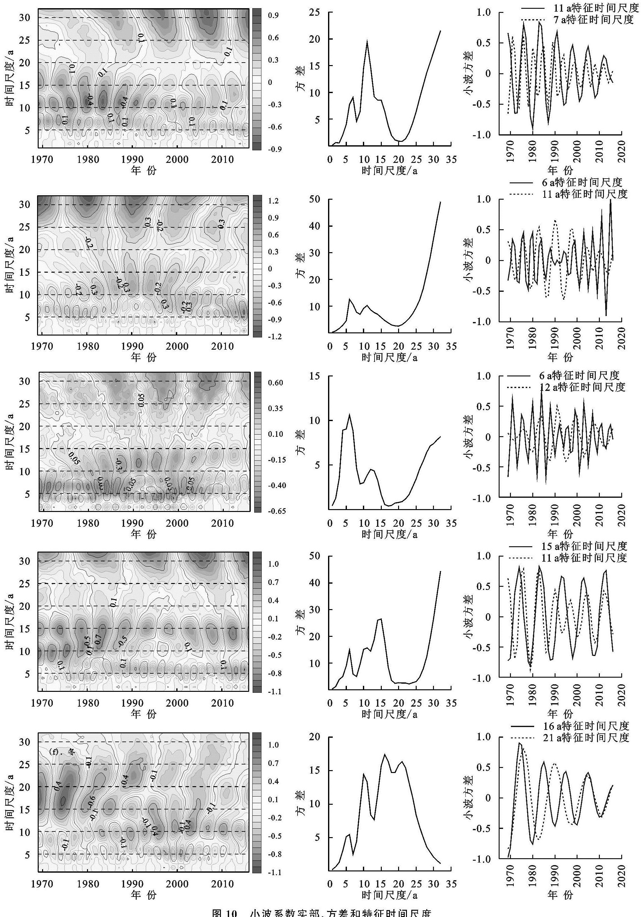
Morlet小波分析中,小波系数实部正负表示丰枯,当小波系数实部值等值线中心为正时,表示偏湿润,反之表示偏干旱; 小波方差用来反映不同时间尺度SPEI指数的能量波动的分布特征,并用来绘制不同时间尺度SPEI指数演变的主要周期。
由图 10可知,在年尺度上,明显存在4~18 a的短周期和20 a以上的长周期; 依据小波分析图可知,第一主周期和第二主周期分别对应11 a,7 a特征时间尺度,另外可能存在更大时间尺度的主周期,但由于时间序列较短,未能表现出来; 在11 a和7 a特征时间尺度上,SPEI-12分别经历了6个和10个丰—枯变化周期,平均变化周期分别为8 a和4.8年。在季节尺度上,春、夏、秋三季的变化周期与年际相似,第一主周期和第二主周期分别为6 a和11 a,6 a和12 a,15 a和11 a,并均可能存在更大的时间尺度周期。冬季明显存在着3~11 a的短周期和12~30 a的长周期; 最大峰值对应着16 a时间尺度为第一主周期,21 a时间尺度对应着第二峰值为第二主周期; 16 a特征时间尺度上,SPEI-3平均周期为10.7 a左右,大约经历了4.5个丰—枯变化周期; 在22 a特征时间尺度上研究区域干旱的变化周期为13.7 a左右,大约3.5个丰—枯变化周期。
3.5 干旱持续性分析
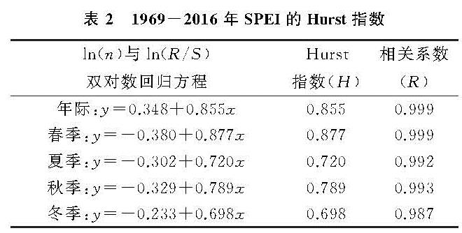
对于渭北黄土台塬区干旱未来变化趋势的预测,采用R/S分析法(表2)。年际SPEI-12的Hurst指数为0.855>0.5,表明干旱具有持续性,即未来渭北黄土台塬区的年际SPEI-12指数变化趋势将维持过去下降趋势一致,干旱化将继续加剧。四季SPEI-3的Hurst指数均>0.5,表明未来四季的SPEI-3指数将维持原来的下降趋势。四季变化趋势强度不同,春季SPEI-3的Hurst指数最大(0.877),持续性最强,表明未来春季SPEI-3指数下降的可能性高于其他季节; 秋季和夏季SPEI-3的Hurst指数次之分别为0.789,0.720,表明未来秋季和夏季SPEI-3指数将维持原来的下降趋势,干旱化将加剧; 冬季SPEI-3的Hurst指数最小(0.698),表明未来冬季SPEI-3指数下降的可能性相较于其他季节最小,即未来干旱化加剧可能性最小。
表2 1969-2016年SPEI的Hurst指数