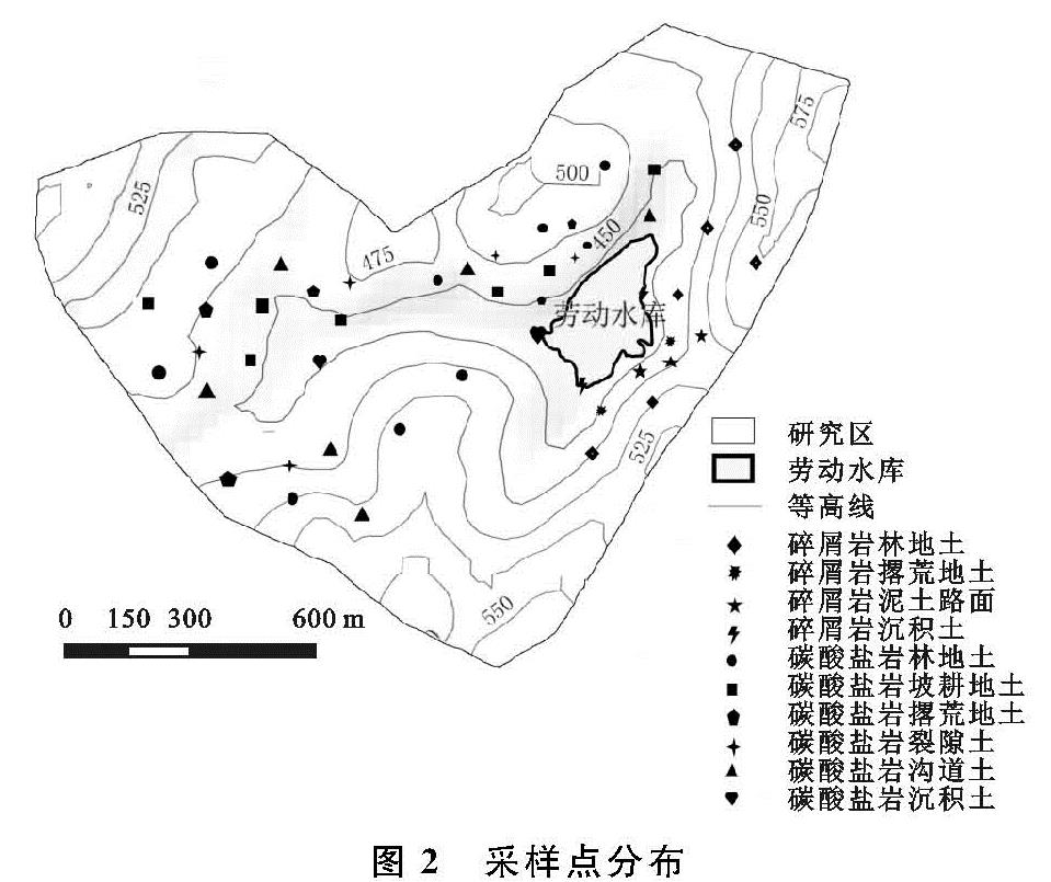
2.1 潜在泥沙来源地土壤性质及指纹因子筛选
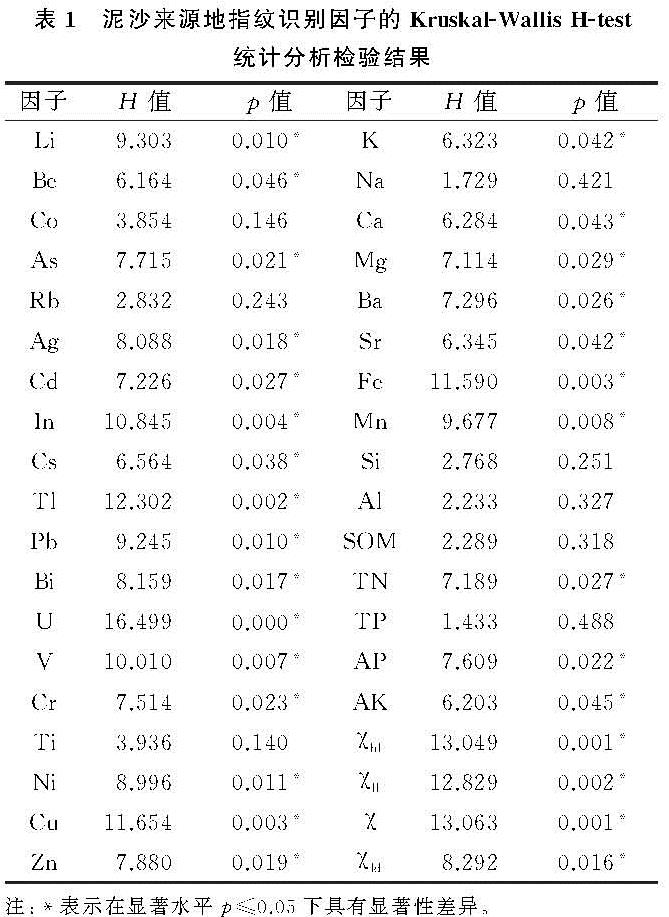
将试验所测的指标包括TN,TP,AP,AK,SOM,χfd,χlf,χhf,χ,K,Na,Ca,Mg,Cu,Zn,Ba,Sr,Fe,Mn,Si,Al,Li,Be,Co,As,Rb,Ag,Cd,In,Cs,Tl,Pb,Bi,U,V,Cr,Ti,Ni按表层土壤、深层土壤、碎屑岩土壤3种泥沙来源地进行无参数Kruskal-Wallis H-test统计分析检验,检验结果见表1。
从上面因子中,可以看出除:Co,Rb,Ti,Na,Si,Al,SOM,TP对应的p值大于显示水平0.05,其他因子的p值均小于0.05,故拒绝因子来自同一泥沙来源地的原假设,即这些因子在不同泥沙来源地间具有显著性差异。
2.2 最佳指纹因子组合确定
2.2.1 最佳指纹因子的构建 首先对3种泥沙来源地中的30种显著差异性指纹因子进行组间均值的均等性检验,根据表2结果显示:显著性差异的因子在均值的均等检验中,除Bi,Ca,Mg,Ak的Sig值大于显著水平0.05,其他因子均小于0.05,共计26种指纹因子均等性检验Sig<0.05,其中Li,Ag,In,Cs,Tl,U,V,Cr,Ni,Cu,Zn,Fe,Mn,χhf,χld,χ共16种因子Sig<0.010具体结果见表2。由此可知,3种泥沙来源地中,表层土壤、深层土壤、碎屑岩土壤Li,Be,As,Pb,Ag,Cd,In,Cs,Tl,U,V,Cr,Ni,Cu,Zn,K,Ba,Sr,Fe,Mn,TN,AP,χhf,χld,χ,χfd等因子具有显著性差异特征,故说明这些显著性因子可以进行多元判别分析。
表1 泥沙来源地指纹识别因子的Kruskal-Wallis H-test
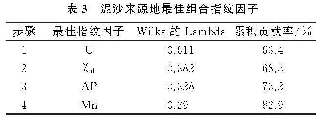
将Kruskal-Wallis检验中刷选出的不同泥沙来源地间具有显著性差异的指标,进入多元判别分析,找出最佳复合指纹组合,采用逐步多元判别分析法,其最终得到最佳因子结果见表3。
从表3可知:最终从这30种因子中筛选,找到了最佳因子组合,其中U,χhf,AP,Mn的累积判别率分别为63.4%,68.3%,73.2%,82.9%,总累积判别率高达82.9%,累积判别率大于80%,属于可接受范围。
2.2.2 判别函数的建立 表4是3种泥沙来源地逐步判别分析后的最佳指纹因子Fisher判别函数系数表,该函数以判别函数值最大的一组进行归类为中心思想,给出了碳酸盐岩表层土壤、深层土壤、碎屑岩表层土壤3个线性分类函数的系数,从而构成3种泥沙来源地的判别函数。
把潜在泥沙来源地样品值代入3个判别方程,即可对该样品进行判断。其中哪个潜在泥沙源地的Y值最大,该样品判别分组就是其对应的分组。下为判别函数:
Y碎屑岩表层土壤=-5.379+0.042U+0.581Mn+0.312AP+0.025χhf
Y碳酸盐岩表层土壤=-14.245+0.061U+1.345Mn+0.482AP+0.058χhf
Y深层土壤=-14.31+0.105U+0.797Mn+0.484AP+0.027χhf
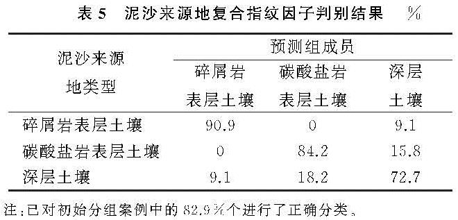
2.2.3 判别结果与分析 通过对劳动水库洼地小流域所采集的泥沙来源地土壤样品进行分类,初始分组中的样本量进行预测分组,对比分析预测组和实际组之间的差异,从而得出不同分组样本归类判别正确率,若正确判别率高于70%,则具有较好判别效果[20]。当有3种泥沙来源地的多元判别分析时,共有U,Mn,AP,χhf,4种单一指纹因子组成最佳指纹因子组合。同时,在这4种最佳因子组合下,3种来源地的预测组与实际组的判别结果如下。由表5复合指纹因子判别结果可知,碳酸盐岩表层土壤、深层土壤和碎屑岩表层土壤3个初始分组,并建立了具有这3种分类的41个样本总体。其中第一组碳酸盐岩表层土壤共有样本量19个,第二组深层土壤样本量11个,第三组碎屑岩表层土壤样本量11个。在SPSS分析过程中,泥沙来源地表层土壤的19个样本量,共计有16个预测组的样本量与实际组一致,即碳酸盐岩表层土壤样品有84.2%的正确判别率; 深层土壤中11个样本量,共计有8个预测组的样本量与实际组一致,其中有1组误判为碎屑岩表层土壤,2组误判为碳酸盐岩表层土壤,即深层土壤样品有72.7%的正确判别率; 在深层土壤的误判率要高于其他源地,最主要的原因深层土壤是沟道、裂隙土,成土木质跟碳酸盐岩和碎屑岩有非常大的关联性。而在碎屑岩表层土壤的分析过程中,11个样本中有10个实现了正确分类,1组误判为深层土壤,也就是说,碎屑岩土壤的正确判别率为90.9%。总体上而言,在U,Mn,AP,χhf4种指纹因子组合下,3种泥沙源地的正确判别率达82.6%。完全符合组合指纹法应用的要求。因此这4种因子可以作为判别该区泥沙来源的最佳指纹因子组合。3种泥沙源地分类判别中,碳酸盐岩表层土壤、深层土壤、碎屑岩表层土壤分别产生15.8%,27.3%,9.1%的错误判别率,这也完全符合组合指纹法应用要求,错误判别率低于30%,因此U,Mn,AP,χhf4种因子可以作为判别该区泥沙来源的最佳指纹因子组合。
2.3 岩溶洼地小流域泥沙来源分析
根据最佳指纹组合在沉积泥沙样品和泥沙来源地中的浓度,在符合公式(2—3)的条件下,使公式(1)最小时得到劳动水库洼地的沉积泥沙,来自不同源地的侵蚀泥沙贡献比。
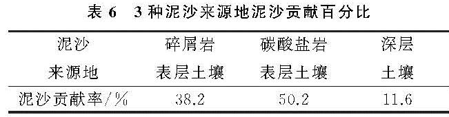
由表6可以看出,3种泥沙来源地贡献百分比均值分别为:碳酸盐岩表层土壤(50.2%)、深层土壤(11.6%)、碎屑岩表层土壤(38.2%)。各潜在泥沙源地中表层土壤的泥沙贡献率最高,碎屑岩表层土壤、深层土壤次之。其中碳酸盐岩表层土壤的泥沙贡献百分比是深层土壤的4.3倍、碎屑岩表层土壤的1.3倍,主要是因为碳酸盐岩区中表层土壤占地面积较大,土层薄,植物根系不发达,地表裸露面积大,一旦降雨,极易产生径流,土壤侵蚀极其严重。同时,由表可知,深层土壤的泥沙贡献率是3种来源地最小的,主要是因为岩溶洼地裂隙的发育,一部分土壤通过地下裂隙漏失,最终到达洼地底部的土壤较少,并且由于洼地面积较小,降雨季节分配差异较大,沟道发育不完全,携带的泥沙流入洼地底部沉积较少,因此在3种潜在泥沙来源地中,深层土壤贡献较少。碎屑岩表层土壤由于土层深厚,植被覆盖率高,而植被有拦蓄水源的功能,因此碎屑岩表层土壤的泥沙贡献率低于碳酸盐岩的表层土壤。