2.1 有机碳含量统计特征
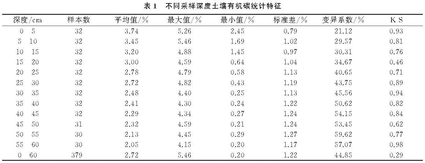
随着深度的增加土壤有机碳含量总体呈现减小的趋势(表1),这与席小康等[7]在锡林河流域草地的研究结果相同。从0—5 cm到55—60 cm平均值降低了1.69%。30 cm以下深度的有机碳平均值低于坡面平均水平。各个深度的有机碳含量都属于中等变异,但是随着深度增加变异系数逐渐增大,这与刘伟等[23]在黄土高原草地的研究结果一致。说明该坡面上层土壤中有机碳含量更为均一,深层土壤中有机碳含量差异相对更为明显。K-S检验表明各个深度的土壤有机碳数据均符合正态分布,可以对其进行地统计分析。
2.2 土壤有机碳含量空间变异特征
土壤有机碳的地统计结果显示(表2),块金值在0.00~0.13,说明在一些深度存在由随机因子引起的土壤有机碳的空间异质性。随着深度增加基台值逐渐增大,表明系统空间内的总变异在增大。块金比分布在0.06%~8.80%,各深度均为强空间自相关,其空间变异主要由结构因子引起,与冯娜娜等[9]坡面尺度的研究结果相同,小于李龙等[18]研究的小流域、中等区域、县域尺度的块金比27.66%,33.42%,36.61%,这些较大尺度有机碳的空间变异由随机因素和结构因素共同引起。大尺度上植被、土壤分布可以综合体现研究区的环境特征,是影响有机碳空间变异的主导因子,而小尺度上植被、土壤分布相对单一,地形是关键因素[18]。表层受到人类活动干扰,变程最小,其他深度变程在100.90—108.50 m,表明表层土壤有机碳的空间自相关距离明显小于其他深度。该坡面变程小于冯娜娜等[9]的311 m,可能原因是本研究选取的是存在4种坡形的不规则坡面,在地形影响下土壤有机碳的自相关距离减弱,变异性增强。以上结果表明,土壤有机碳的空间变异特征及其影响因素具有明显的尺度效应,对坡面尺度土壤有机碳的研究具有重要意义。
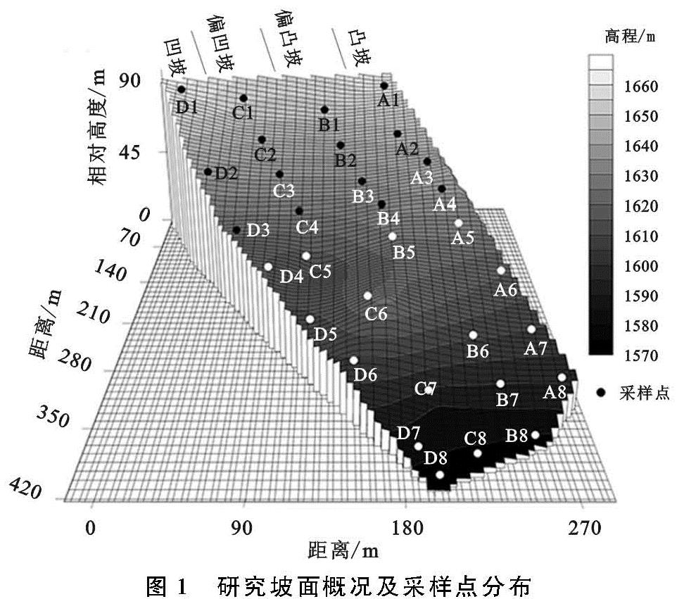
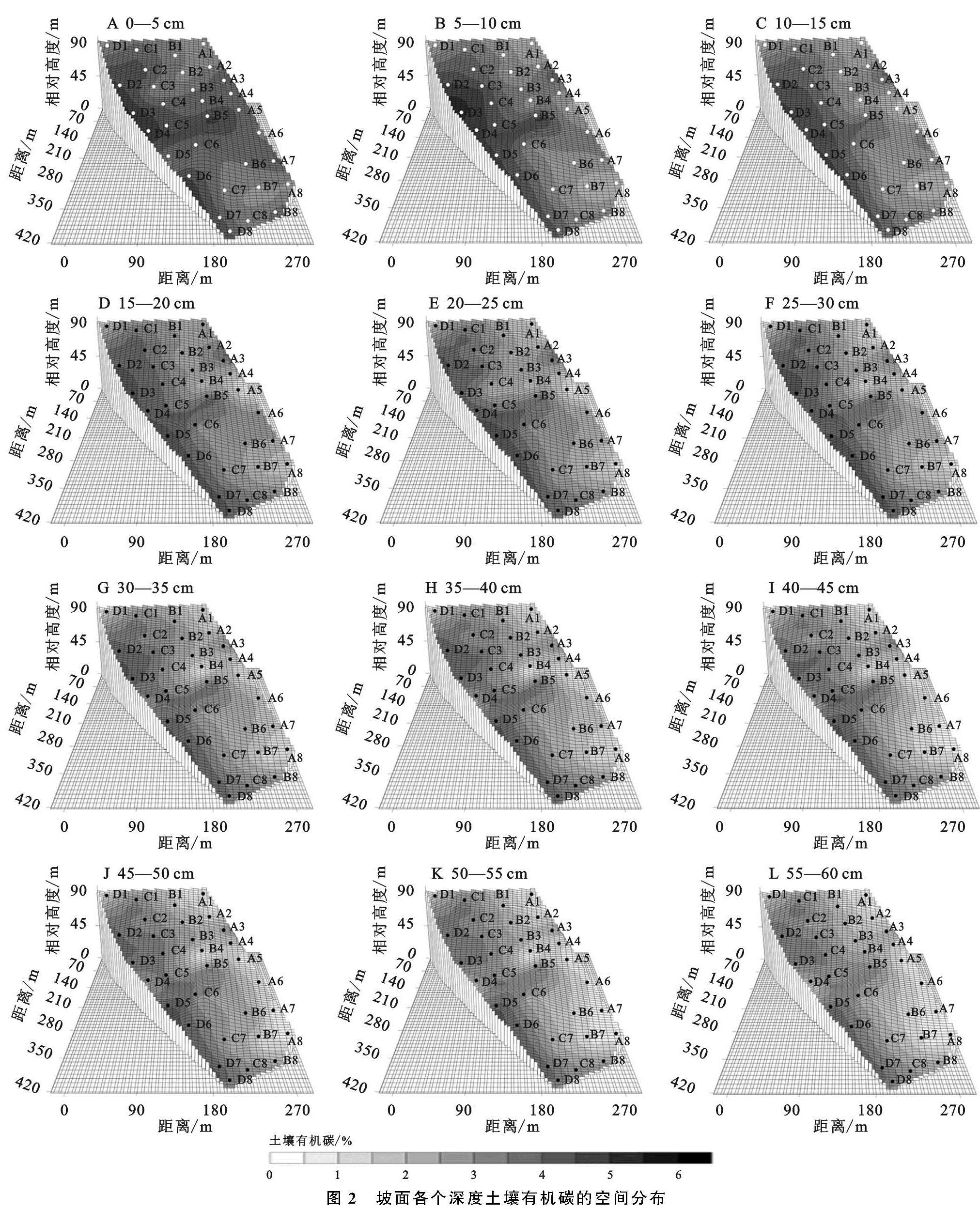
土壤有机碳插值结果显示(图2),各层有机碳含量的空间分布特征较为一致,沿坡形走向呈条带状分布,总体趋势为从凸坡向凹坡逐渐升高。Wiaux等[12]对黄土侵蚀坡面有机碳分布的研究也认为凸形坡肩的有机碳含量比其他地貌类型更低。表层坡中有机碳含量高于坡上和坡下部位。在坡形和坡位的综合作用下,凹坡中下部土壤有机碳含量高,偏凹坡和偏凸坡中部有机碳含量较高,而凸坡在深层坡中上部位高于坡下。表层到深层有机碳含量总体呈降低趋势,表层受人为因素的干扰,减弱了表层各坡形之间的差异,而深层差异相对较大。A3,B5,B8,C1,D5,D6点在对应的坡形中各个深度有机碳含量都较高,A1,A8,B7,C7,D1点在对应坡形的各个深度都较低,A5,B4,C2,D4点从表层到深层有机碳含量降低的比较明显。坡面有机碳的最大值位于5—10 cm凹坡的D3点,最小值位于55—60 cm凸坡的A2点。以上结果表明,微地形中的坡形和坡位是影响坡面土壤有机碳含量空间变异的关键因素。
2.3 土壤有机碳含量随深度变化特征
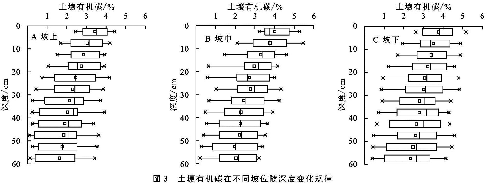
按采样点的海拔将其分为坡上、坡中、坡下3个坡位。有机碳含量在各个坡位均呈现由表层至深层逐渐减小的特点,且坡中有机碳含量随深度减小的速率相对更大(图3)。总体上有机碳含量坡下>坡中>坡上,基本符合有机碳在坡上随土壤侵蚀流失,搬运、堆积在坡中、坡下的一般规律,这与何燕等[24]研究结论相似。坡下和坡中之间没有显著差异,而坡上与坡下、坡中差异显著(p<0.01)。与总体趋势不同,有机碳含量在表层0—10 cm表现为坡中>坡下>坡上。
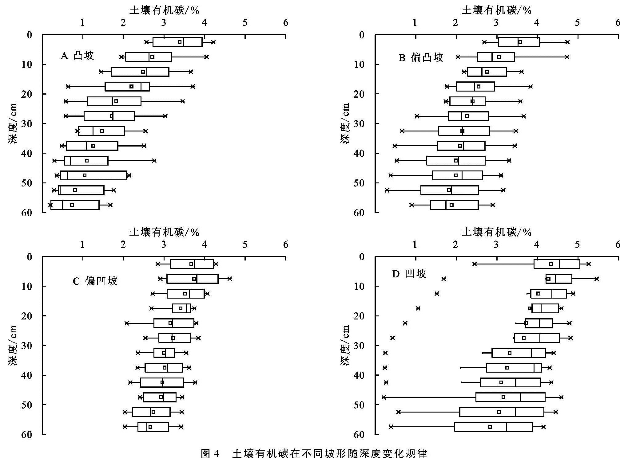
随着土层深度的增加有机碳含量在4个坡形均减小,其中凸坡减小的速率相对最快,偏凸坡和凹坡次之,偏凹坡减小的最慢,且随着深度增加坡形之间的差异越明显(图4)。各深度有机碳含量均呈现凹坡>偏凹坡>偏凸坡>凸坡,凹坡、偏凹坡与其他坡形间差异显著(p<0.01)。杨丹等[8]的研究表明在不同深度土壤有机碳含量与地形的凸凹度有一定的负相关关系。凹坡有一个有机碳含量明显偏小的点(D1),该点位于凹坡顶部,是坡面采样点中海拔最高的点,在各个深度有机碳含量都明显低于凹坡的其他样点。
2.4 土壤有机碳空间变异机制
以上结果表示坡面土壤有机碳空间差异较大,受结构因子的影响,各层均为强空间自相关性,但在一些深度也受人为活动的干扰产生一定的随机差异。研究区为小尺度草地坡面,气候、土地利用条件一致,结构因子主要是地形、土壤性质和植被,随机因子为试验误差、放牧等人类活动。
坡位和坡形是导致坡面有机碳含量空间变异的重要因子,有机碳含量从地势高的排水区向低洼汇水区递增(图3)。土壤在排水区更易受到侵蚀,而土壤侵蚀优先使与细颗粒结合的有机碳在流水及重力作用下迁移流失,并堆积在汇水区[14]。土壤有机碳含量与土壤颗粒大小有密切关系,砂粒含量大的土壤水肥易流失,而粉粒对土壤水分有效性具有正效应,黏粒通过与有机碳结合形成有机—无机复合体对有机碳有保护作用[25]。该坡面土壤机械组成的空间变异研究[21]表明坡上、坡中部位及凸坡砂粒含量较高,黏粒和粉粒主要分布在地势较低的坡下和偏凹坡、凹坡。此外,地势低洼区土壤水分含量高,有利于减缓有机碳的矿化[14]。
土壤有机碳含量与根系生物量分布趋势相似。植物根系死亡后进入土壤碳循环过程,是草原土壤有机碳的重要物质来源[4],其对土壤有机碳储量的贡献远大于地表植被[26]。该坡面地表植被条件较为一致,但根系生物量的差异较为明显[27],极大值多出现在凹坡和凸坡,但凹坡有机碳含量却显著大于凸坡。凹坡优越的水土条件利于植物根系生长,为凹坡有机碳的形成提供了物质基础,而凸坡土壤砾石含量高、土壤粗化严重,冷蒿根系攀附于砾石对土壤侵蚀不利条件做出逆反馈,有机碳含量随土壤侵蚀加剧而进一步减小。根系的垂直分布特征及分解速率对不同深度有机碳含量有直接影响[25]。0—20 cm的有机碳含量显著高于下层,底层仅为表层的55%,该坡面植被根系生物量表层明显大于深层,且微生物活动更强,导致有机碳含量高。例如浅层的A3,A6点、深层的D6点附近根系含量较大,有机碳含量也高。此外,偏凹坡随深度增加有机碳含量减小的速率最缓,这与偏凹坡的根系生物量呈现出相似特征。
表层土壤有机碳含量受人类活动的影响而降低。与其他土层不同,该坡面表层0—10 cm深度坡下有机碳含量小于坡中(图3)。坡底为一级河流阶地,同时有乡间土路穿过,牲畜踩踏、人车通行对坡下表层土壤扰动较大,破坏坡下的植被及土壤结构,降低了有机物质的输入和分解,进一步导致有机碳含量降低,减弱了坡形、坡位的影响程度,王明君等[11]的研究也发现同样的问题。
地形控制着坡面的水热再分配,决定了坡面水土流失的方向和强度,影响土壤性质的空间变异。粉粒和黏粒与有机碳聚合形成胶体对有机碳积累具有正效应,在相同动能条件下比砂粒更易被侵蚀、搬运,土壤有机碳也表现出相应的空间分布特征。植物根系是有机碳积累的重要物质来源,其分割、粘结作用也利于土壤团粒结构的形成,改善土壤结构。植物根系的垂直分布及分解速率差异形成了不同深度有机碳的空间变异。