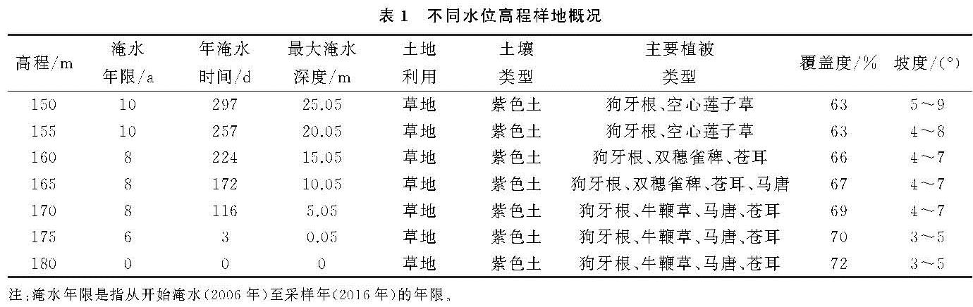
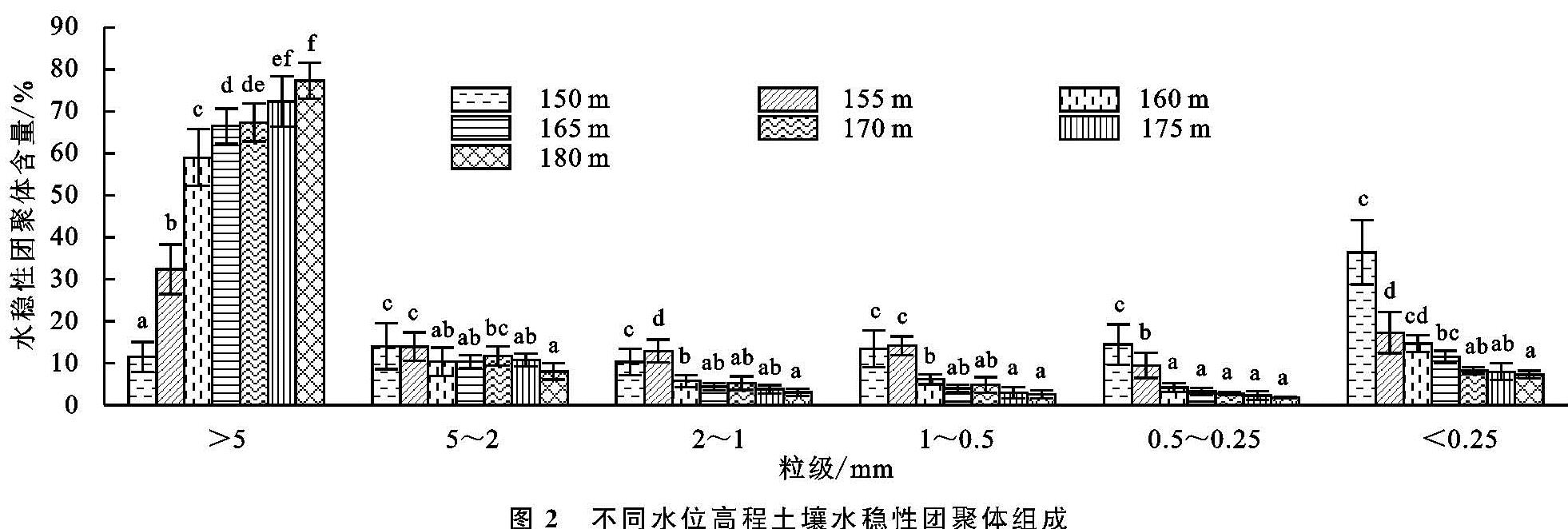
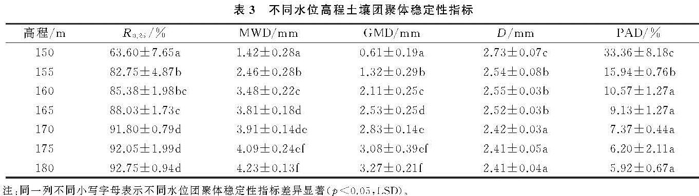
三峡水库消落带水位周期性涨落导致不同水位高程土壤的淹水浸泡时间、淹水深度、水柱压力、干湿交替频率和幅度等具有差异(表1),显著影响了土壤非水稳性和水稳性团聚体组成。本研究发现,与非消落带180 m土壤相比,消落带内>5 mm的非水稳性和水稳性团聚体含量显著降低,其余5个粒级的非水稳性和水稳性团聚体含量显著增加; 随着水位高程的降低,>5 mm的非水稳性团聚体和水稳性团聚体均显著降低,而<0.25 mm的非水稳性团聚体和水稳性团聚体均显著增加。表明三峡水库消落带周期性水位涨落使得部分大粒径团聚体崩解为小粒径团聚体或微团聚体,且随着水位高程降低,变化幅度增大,这可能与消落带水位快速升降引起的团聚体崩解有关。陆铸畴等[16]研究表明三峡库区消落带土壤团聚体的破坏主要是由土壤孔隙中的气泡爆破产生的消散作用引起的。紫色土结构水稳性极差,在淹水过程中,水分迅速进入团聚体内部挤压空气造成团聚体内部压强增大从而发生崩解,随着水位高程的降低,淹水深度和时间增加,水压力增大,干湿交替更加频繁,紫色土软化和泥化程度增大,土壤粘结力降低,促进团聚体水化,增强消散作用,导致大粒径团聚体破碎为小粒径团聚体的含量增加。本研究表明,150 m水稳性团聚体含量变化最为显著,可能是因为150 m处水位较低,除受周期性水位涨落影响外,还受波浪和行船引起的涌浪的影响,土壤结构破坏程度大,淹水过程中团聚体更易崩解。
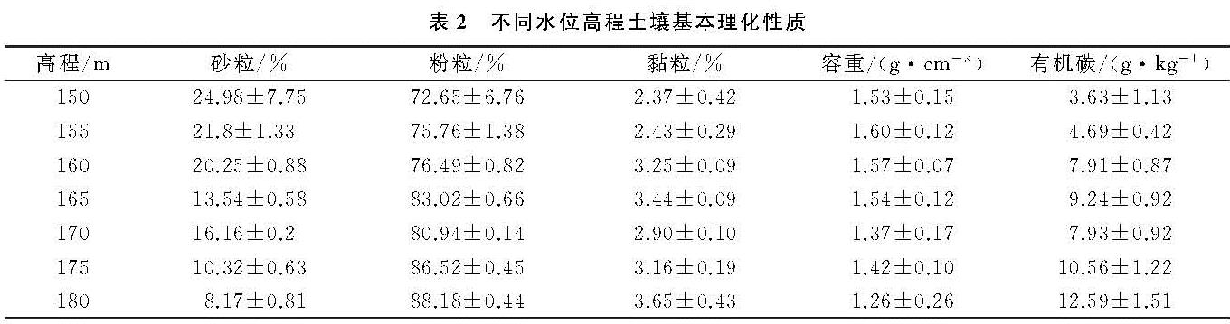
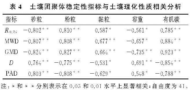
三峡水库消落带水位周期性涨落对土壤团聚体稳定性影响显著。本文研究发现,>0.25 mm水稳性团聚体含量、平均重量直径和几何平均直径均随着水位高程的降低而降低,而分形维数和团聚体破碎率则随着水位高程的降低呈增加的趋势。表明团聚体稳定性随着水位高程的降低显著降低,而陆铸畴等[16]研究结果则表明,消落带中间高程团聚体最稳定,低水位高程团聚体稳定性最差,这种差异可能与研究区的植被组成、有机质含量、土地利用和研究方法等不同有关。干湿交替主要通过影响团聚体孔隙结构和微生物群落活动,进而影响团聚体的胀缩和胶结剂的稳定性,改变团聚体水稳性[6]。本文中团聚体稳定性随着水位高程的降低而显著降低,可能是因为受淹水时间、淹水深度、干湿交替频率和强度的影响,消落带不同水位高程植物生长、动物及微生物活动和土壤性质等发生变化,进而影响土壤团聚体稳定性。随着水位高程的降低,淹水时间和淹水深度增加,植被的生长期变短,植被的多样性和覆盖度降低(表1),植物根系及根系分泌物减少,对土壤团聚体的穿插与缠结作用降低,土壤团聚体更易分散。消落带动物如蚯蚓和蚂蚁等的排泄物和挖掘洞穴等活动可影响团聚体的形成和稳定性,微生物群落活动通过影响团聚体胶结剂的分解和合成,改变土壤团聚体稳定性[6]。三峡水库消落带土壤环境因子如温度、湿度和氧气等随着淹水时间和淹水深度的增加而发生变化,造成消落带土壤动物及微生物活动随着水位高程降低而受到限制,影响土壤团聚体稳定性。土壤理化性质中,有机胶结剂土壤有机质和无机胶结剂土壤黏粒对于团聚体的稳定性具有重要作用。本研究表明消落带土壤团聚体稳定性与土壤黏粒和有机碳之间均具有显著或极显著相关性(表4),但与黏粒相比,团聚体稳定性与有机碳之间的相关性更为显著,主要是因为本研究中土壤黏粒含量极低(表2),对团聚体的胶结作用较弱,该区域主要以有机碳的胶结作用为主。土壤有机质作为一种重要的胶结物质,不仅可以增强团聚体之间的粘结力,而且土壤有机质在团聚体周围形成疏水表面层,可以减缓土壤湿化速率,降低消散作用,提高团聚体稳定性[17]。本文中土壤有机碳随着水位高程的降低显著降低(表2),导致消散作用强度随着水位高程降低而增强,团聚体稳定性降低。本文通过对消落带不同水位高程的团聚体特征进行分析,揭示了消落带水位周期性涨落对团聚体组成和稳定性的影响,今后应加强其影响机制的研究。