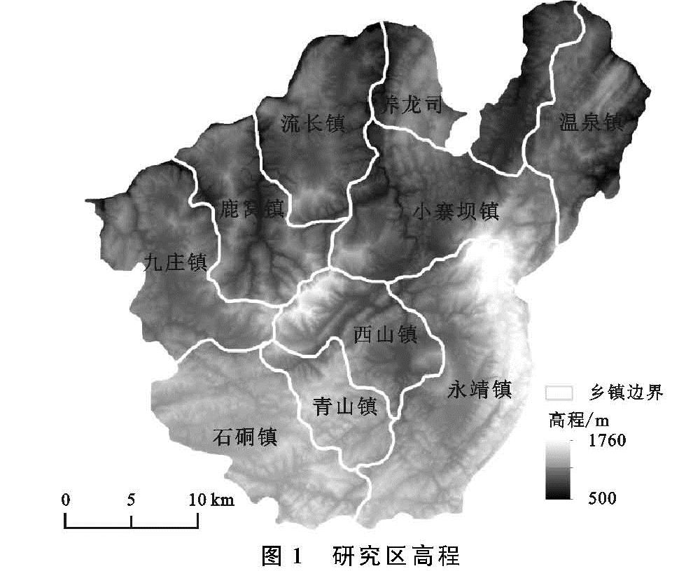
1.3.2 耕地生态风险求取
景观生态风险评价中所涉及的风险源一般包括自然风险源与人为风险源[23]。耕地是人类发展过程中形成的农业景观,根据李景刚等[24]相关研究,其生态风险受外部压力、景观暴露性以及景观稳定性影响,本文中耕地景观的生态风险是根据风险概率及风险损失的乘积,分别对不同石漠化等级耕地进行求取。其中所涉及到的权重赋值[25-26]都是根据熵权法计算得到,具体流程如图2所示。
喀斯特地区耕地除了受到剧烈的人为影响之外,还受到复杂地区的影响,于是分别选取道路、地形、水源、农户施肥量、土地利用比作为喀斯特地区耕地的风险源; 选取景观指数中景观破碎度、景观分离度、景观优势度等参数,计算得到景观自然损失度。结合生态损失指数法[27],计算景观干扰指数Si与景观脆弱度指数Fi综合得到景观生态风险程度。具体计算公式表示为:
CERi=AERPi·NSLIi(1)
式中:CERi为风险区i的综合生态风险; AERPi,NSLIi分别为风险区i的耕地生态风险概率和景观自然损失度。
(1)景观风险概率计算。耕地景观风险概率是农户干扰胁迫因子、土壤污染胁迫与外部距离胁迫之间的综合表征,本文中又将外部胁迫因子划分为道路胁迫因子、地形胁迫因子、水源胁迫因子。计算得出农户干扰因子、土壤污染胁迫因子、道路胁迫因子、水源胁迫因子、地形胁迫因子权重取值为:0.29,0.23,0.16,0.18,0.14。计算公式为:
AERPi=∑5j=1λjPij(2)
式中:AERPi为景观风险概率; λj为风险源的权重; Pij为各风险胁迫; i为风险区; j为风险源种类(农户干扰胁迫、土壤污染胁迫、道路、水源距离胁迫、地形起伏)。
农户干扰因子:耕地景观受到的人类活动影响程度不断加深,农户干扰胁迫是指农民对景观环境施加的胁迫
[28]。由于耕地是一种特殊的人为景观,其面积的大小体现出农户对于环境的影响程度,本文利用土地利用比(耕地面积与土地总面积的比值)作为农户干扰胁迫。
土壤污染胁迫因子:耕地景观最直接和最明显的污染源来自于农药化肥的影响,故利用农户施肥量(农业化肥量与耕地总面积的比值)作为各生态区的土壤污染胁迫。其农药化肥量包括复合肥、磷肥、钾肥使用总量。
外部胁迫因子:外部胁迫包括道路、地形、水源对耕地分布环境造成的胁迫。道路与水源的距离一定程度上与生态服务价值呈反比,其距离越近,生态服务价值降低风险概率越大,即景观生态风险也就越大。相应的,地形起伏越大的地区,其耕地生态服务降低的风险也相对大。
DIS=1/(1+(d/δj))(3)
Sx{1 slope≤5
-0.1slope+1.5 5<slope<15
0 slope≥15(4)
式中:DIS为其距离胁迫; d为距离变量,结合ArcGIS空间分析,计算各耕地类型地块与水源点和道路的距离,并以生态区为单位计算各类型的距离平均值d; δj为距离衰减系数,文章中衰减系数取值500。Sx为坡度胁迫风险概率; slope为斑块坡度,将坡度值赋值到不同耕地地块中,求得不同地块坡度胁迫,按照所占比重情况计算最后生态区的坡度胁迫风险概率值。
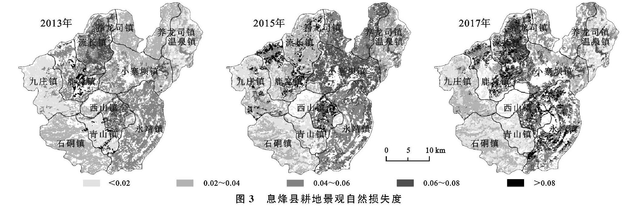
(2)自然损失度计算。自然损失度由景观干扰指数和景观脆弱度指数求得,分别得到每类耕地在不同风险区的自然损失度。
NSLIi=Si·Fi(5)
式中:NSLIi为风险区自然损失度; Si为i风险区的景观干扰度指数; Fi为i风险区的景观脆弱度指数。
① 景观干扰指数。由于不同景观在结构、功能、分布等方面有所差异,其对外界的抗干扰能力也不同,根据景观破碎度指数、景观分离度指数、景观优势度指数所计算得出的景观干扰度指数(Si),可以表征不同景观所代表的生态系统受到的干扰程度。本文中结合息烽县实际情况,并根据不同采样小区的对比,发现以400 m×400 m为采样小区面积,所包含的地类最全面,所以本文以400 m×400 m建立息烽县渔网以作为息烽县采样小区,计算景观优势度等参数。查阅相关资料并结合喀斯特地区地形因素,认为景观破碎度指数相较于景观破碎度和景观分离度更为重要,其次,景观分离度较景观优势度更为重要,则将各自权重分别赋予0.6,0.3,0.1以计算景观干扰指数,具体公式参照谢花林[29]、李谢辉等[30]文章。
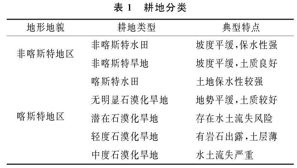
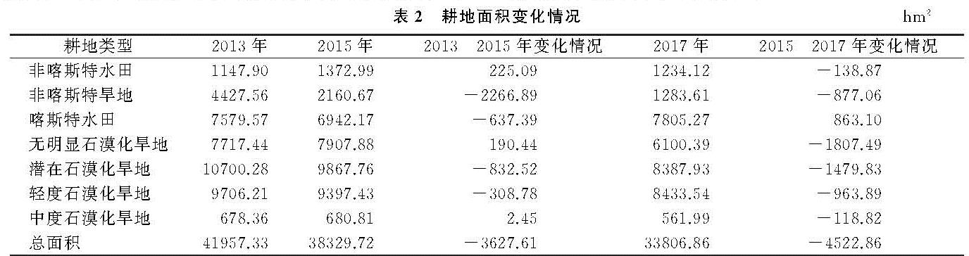
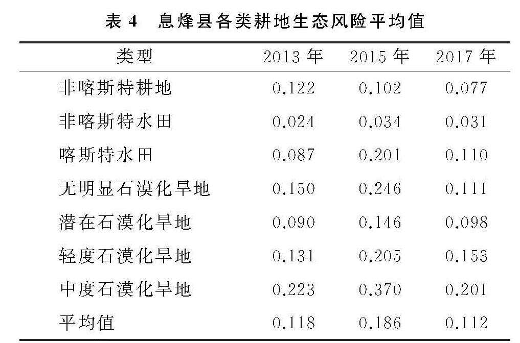
② 景观脆弱度指数。景观脆弱度指数(Fi)是景观脆弱状况的定量化表达,本文按照石漠化分级将耕地分为7种类型。由于石漠化伴随着土壤物理性质变差、土壤养分下降、土地质量退化,随着石漠化程度的加剧,其景观脆弱性也随之加剧[31],因此本文分别对7种类型赋予脆弱度指数:非喀斯特地区水田为1,非喀斯特地区旱地为2,喀斯特地区水田为3,无明显石漠化地区旱地为4,潜在石漠化地区旱地为5,轻度石漠化地区旱地为6,中度石漠化地区旱地为7,并对其进行归一化处理。
1.3.3 灰色关联矩阵计算相关性
为验证耕地生态风险与经济发展存在的相关性,本文选取乡村从业人数、工业增加量、农业机械总动力、农村用电量、城镇人均收入、农村人均收入、第三产业收入、城镇人口、总人口等指标与耕地生态风险进行灰色关联矩阵分析。由于数据之间的量纲不同,计算关联度之前需对数据进行标准化处理,得到景观生态风险变化矩阵与城镇化指标变化矩阵,标准化方法为:
X'ij=(Xij-min(Xij))/(max(Xij)-min(Xij))(6)
式中:X'ij为标准化值; Xij为第i年第j个指标; min(Xij),max(Xij)分别为Xij中的最小值和最大值。
灰色关联分析方法表达式为:
εi(k)=(min min|x0(k)-xi(k)|+ρmax max|x0(k)-xi(k)|)/(|x0(k)-xi(k)|+ρmax max|x0(k)-xi(k)|)(7)
ri=1/n∑nk=1εi(k)(8)
式中:εi(k)为xi列与x0列的第k个元素间的关联系数; ri为关联度; ρ为分辨系数,用以削弱Δ(max)过大而引起的误差,通常取0.5。参数min与max的取值通过对比不同时期指标的绝对差值确定。